VANCOUVER, BC / ACCESS Newswire / December 22, 2025 / Prospect Ridge Resources Corp. (the "Company" or "Prospect Ridge") (CSE:PRR)(OTC:PRRSF)(FRA:OED) is pleased to announce visual observations and portable X-ray fluorescence spectrometer (pXRF) results for the final four holes of a ten hole diamond drill program at the Company's 100% owned Camelot copper-gold project in British Columbia's prolific Cariboo Mining District.
A total of 2,010 m was drilled in 10 holes from eight drill pads over a 21 day drill campaign (see Table 1 for drill collar locations). All drill sites, access roads and trails have now been rehabilitated and all field activities, with the exception of reseeding of some pad locations, have been completed.
Visual core and pXRF results for the first six holes were provided in a news release dated December 4, 2025, whereas this news release summarizes results for the final four holes (CAM25-007 to CAM25-010). These four holes comprise 903 metres of drilling completed from three sites along the northeastern portion of a 1.7 km long prospective geochemical and geophysical trend (Figure 1). The most northeastern hole (CAM25-009) was collared 1,740 m northeast of the first hole (CAM25-001), illustrating the scale of the porphyry potential at Camelot.
Drilling initially targeted historical copper-in-soil anomalies coincident with chargeability highs and moderate magnetic highs, following an alkalic porphyry exploration model where such coincident features could indicate pyrite-chalcopyrite mineralization in association with magnetite-bearing potassic alteration. The target area is covered by till and has never been drill tested until this 2025 program (Figure 2).
Drilling Highlights
Semi-quantitative real-time elemental analysis of drill core with a pXRF, coupled with visual observations, confirm presence of disseminated pyrite and chalcopyrite in holes CAM25-007, -008, 009, and -010.
Mineralized intervals are associated with overprinting alteration and vein assemblages, particularly in hole CAM25-009. These intervals exhibit multiple episodes of moderate to strong porphyry-style alteration and veins, which include moderate to strong K-feldspar, albite, and epidote alteration.
To test as many targets as possible, eight of ten holes were stopped at about 200 m despite the presence of pyrite and chalcopyrite at the bottom of most holes. Hole CAM25-004 was stopped at 102 m and CAM25-10 (which tested a deeper geophysical target) was extended to 301 m. Drill core samples from holes CAM25-007 and CAM25-009 have been sent for "rush" assay.
Visual and pXRF results from the first six holes confirmed a positive correlation between higher pyrite and chalcopyrite values and chargeability highs and led to modifications in the collar location of the final four holes.
Inspection of partially assayed core from historical drill hole LL22-001, which was collared in approximately the same location as CAM25-009 but drilled away from a chargeability high target (azimuth 128o; inclination -70o) revealed that the bottom ~192 m of the hole had only been assayed for three of every fifteen meters of core. Subsequent oxidation of this drill core led to improved identification of previously unrecognized chalcopyrite, leading to the decision to cut and assay the previously unsampled core.
Len Brownlie, Ph.D., CEO of Prospect Ridgenoted "We feel very fortunate that our initial drilling into "blind" targets identified by geophysical data under glacial till has uncovered evidence of an alkalic porphyry that is copper bearing. This is a tremendous technical accomplishment and I would again like to thank Equity Exploration Consultants Ltd., and Dorado Drilling for their quick and efficient execution of this drill program. If the observed association between chargeability highs and elevated copper mineralization is confirmed by assay results then it becomes the primary tool to identify future drill targets at Camelot. We look forward to receiving and publishing gold and copper assay results early in the New Year and then planning a follow-up drill program for Camelot in 2026".
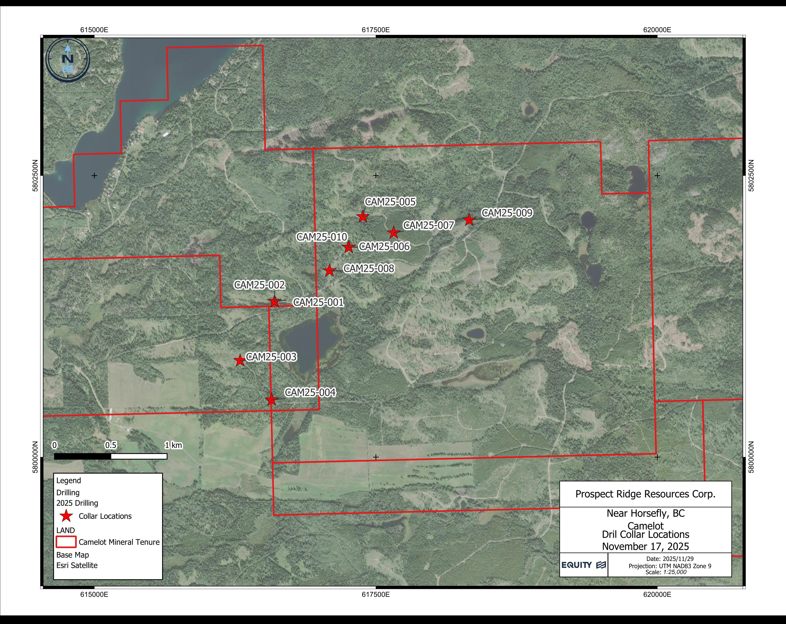 Figure 1: Map showing location of drill hole collars on the Camelot property.
Portable XRF
A pXRF analyzer has been used to aid in the identification of very fine grained and disseminated chalcopyrite in rocks where strong alteration impedes visual confirmation. The pXRF provides reliable copper verification, in this case taken as spot samples from a ~0.5 cm2 area of drill core at 1 m intervals.
Despite their reliability, pXRF analyses of drill core are less representative than wet-chemical assays - as they represent such a small quantity of rock - and in this particular case should be regarded as a qualitative screening tool that complements visual core logging.
Portable XRF analyses have detected the presence of copper in all four holes described here. Copper measurements are shown as histograms in the cross-section for hole CAM25-009 (see drill hole cross-section) and demonstrate continuity and variance in copper grades that are consistent with visual logging (see below).
Accurate copper and gold values will be determined by wet geochemical and fire assay methods, respectively. Samples from holes CAM25-007 and CAM25-009 were submitted to the lab on a "rush" basis so that assays are expected in late December. True widths of mineralization are unknown at this time.
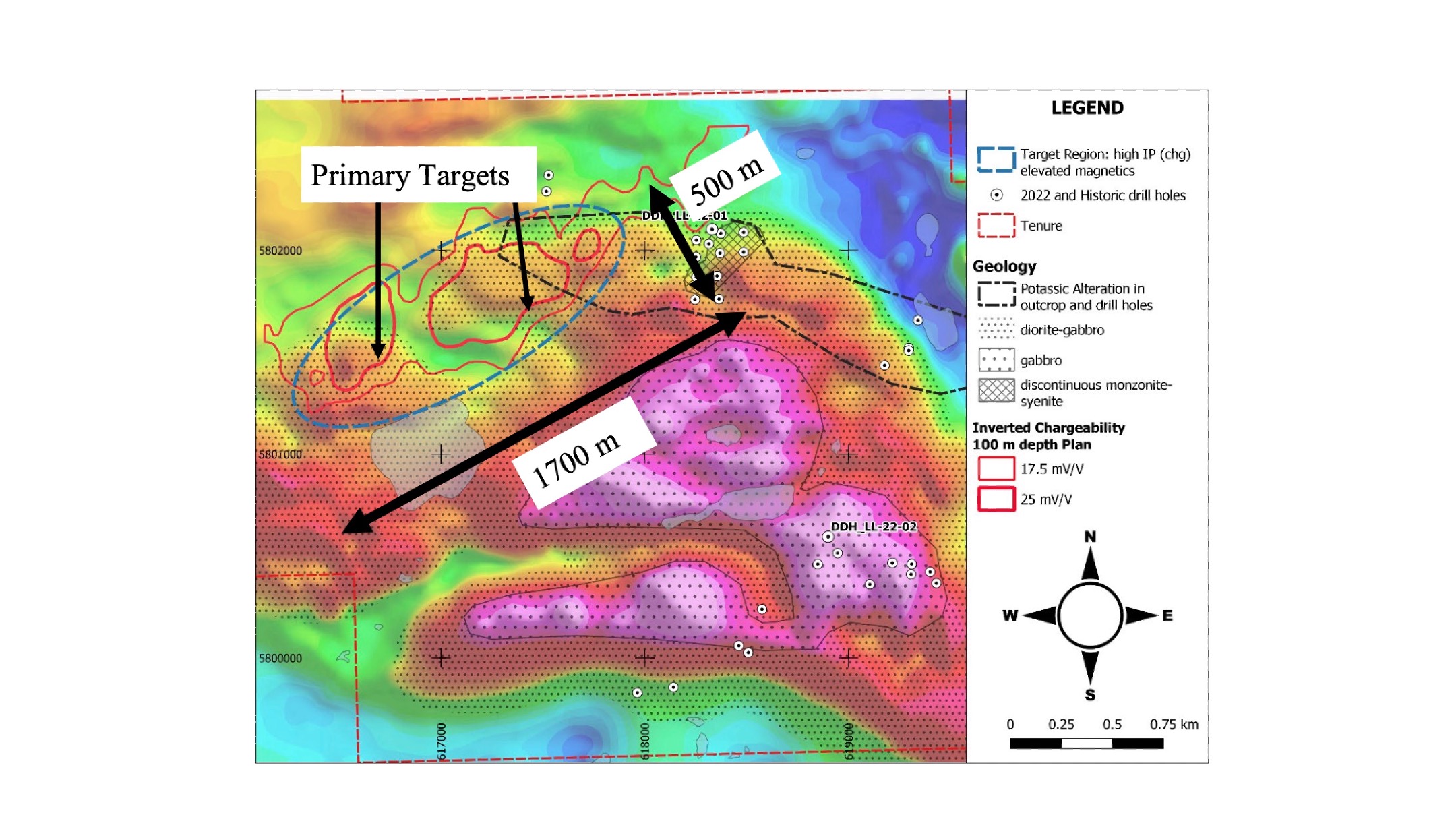 Figure 2: Property geology, soil geochemistry, and IP data compilation over airborne total magnetic intensity (TMI) map (after Baknes, 2023i).
Visual Observations in Drill Core
Photos of selected core intervals from hole CAM25-009 are shown in Figures 3 and 4. These photos illustrate the typical intrusive rock units associated with the presence of pyrite (py) and chalcopyrite (cpy) seen in altered sections of the drill core.
Alpha Target
The Alpha target features a large high chargeability anomaly with isolated magnetic anomalies that suggest pipe like intrusive structures. The chargeability high is underlain by a moderate-low resistivity feature. Four drill holes, collared from three pads, tested the Alpha target (Table 1).
As noted in the December 4 press release, drill hole CAM25-005 intersected mostly weak to moderately pyrite-mineralized diorite with trace to weak disseminated chalcopyrite, and elevated (2-5%) quartz and quartz-carbonate veinlets while drill hole CAM25-006 intersected variably K-feldspar altered andesite, diorite, and monzodiorite, hosting minor amounts of fine disseminated pyrite and 1-4% pyrite veinlets, as well as weak to trace very fine grained chalcopyrite from 140 m depth to the end of hole.
CAM25-008 intersected moderate to strong K-feldspar-biotite-chlorite altered monzodiorite and diorite intruding andesite and hosting 0.5-5% disseminated fine grained pyrite and trace fine grained chalcopyrite.
CAM25-010 intersected weak to moderate K-feldspar-biotite-chlorite altered andesite intruded by narrow (8-25 m) diorite, monzodiorite, and monzonite, hosting 1-5% disseminated pyrite and rare chalcopyrite.
Bravo Target
The Bravo target is a chargeability high anomaly coincident with pipe-like magnetic anomalies.
CAM25-007 intersected moderate K-feldspar-biotite-chlorite-epidote altered monzonite intruding andesite, hosting 1-3% disseminated pyrite with fine grained disseminated chalcopyrite detected through pXRF analysis. Rare quartz vein hosted chalcopyrite was also encountered.
Echo Target
The Echo target is a chargeability high on the shoulder of a moderate magnetic anomaly. Drill hole CAM25-009 was drilled at -60 degrees to the northwest to test the chargeability high anomaly adjacent to a moderate magnetic high at depth and was successfully drilled to the target depth of 201 m.
The target concept for this drill hole was to test a chargeability anomaly that is caused by disseminated pyrite, as earlier drill holes in this campaign found a positive correlation between chalcopyrite and the more abundant pyrite. The significance of the adjacent magnetic anomaly is undetermined - previous drill holes found magnetic anomalies to be caused by different geological features, including magnetite alteration.
The drill hole successfully proved the target concept since visual logs confirmed the highest concentrations of chalcopyrite to coincide with the chargeability anomaly. Real-time semi-quantitative elemental analysis by pXRF measurements substantiate the increased presence of copper in that section.
The drill hole encountered volcanic rocks cut by felsic dikes, both with a moderate (calc-)potassic alteration assemblage of epidote-magnetite-chlorite-K-feldspar and host to quartz veins with albite halos. Both lithologies are mineralized with pyrite and chalcopyrite. The fact that no substantial felsic intrusive was encountered in this drill hole could be because the causative intrusion might still be found at depth or that there simply isn't one, similar to some porphyry-style deposits, like the nearby Mount Polley Mine for example, that lack an obvious causative intrusion and consist solely of ore bodies hosted in country rock.
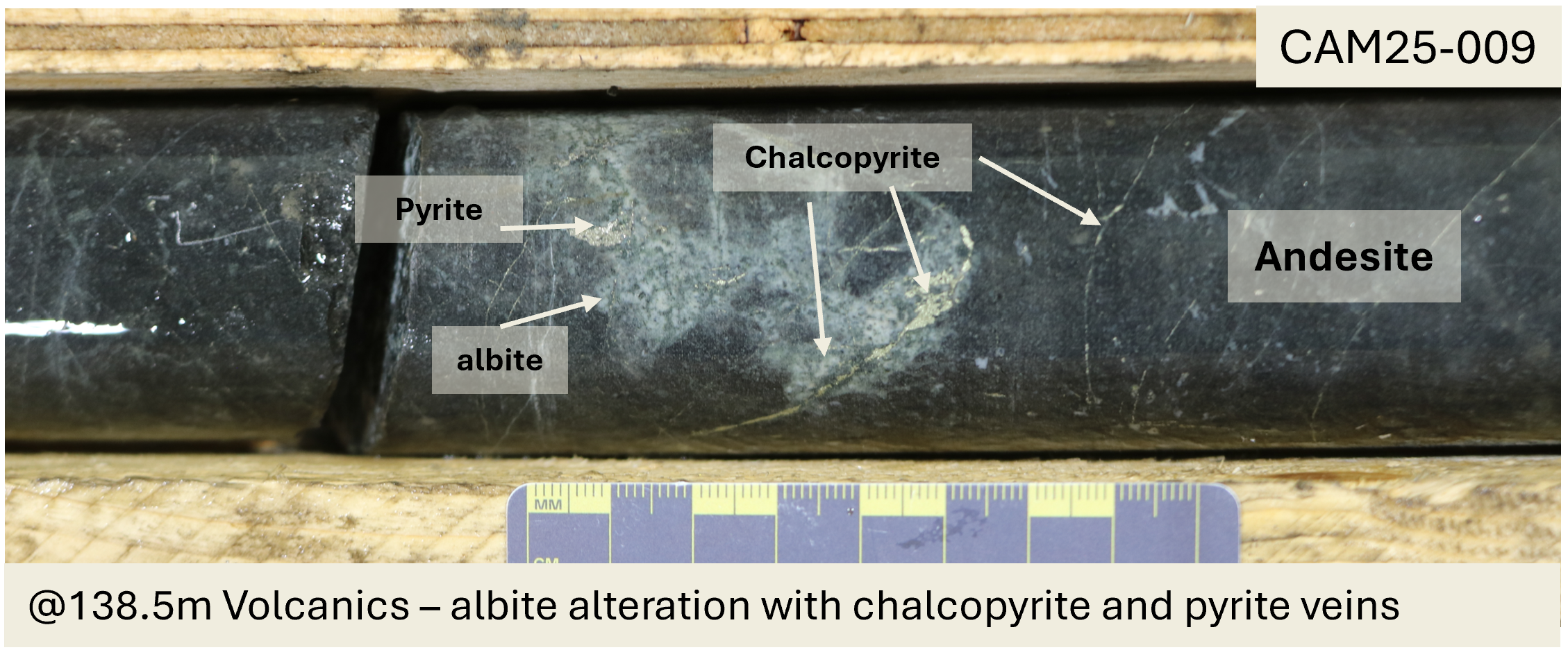
 Figure 3: Photos of chalcopyrite mineralization and alteration within core from hole CAM25-009 at drilled depths of (top) 109.1 m and (bottom) 138.5 m from the top of hole.
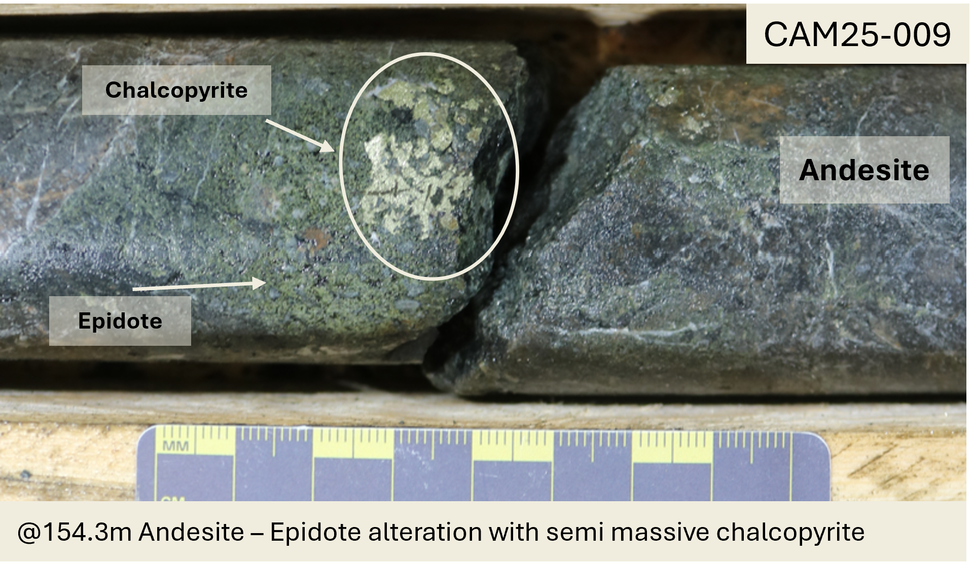
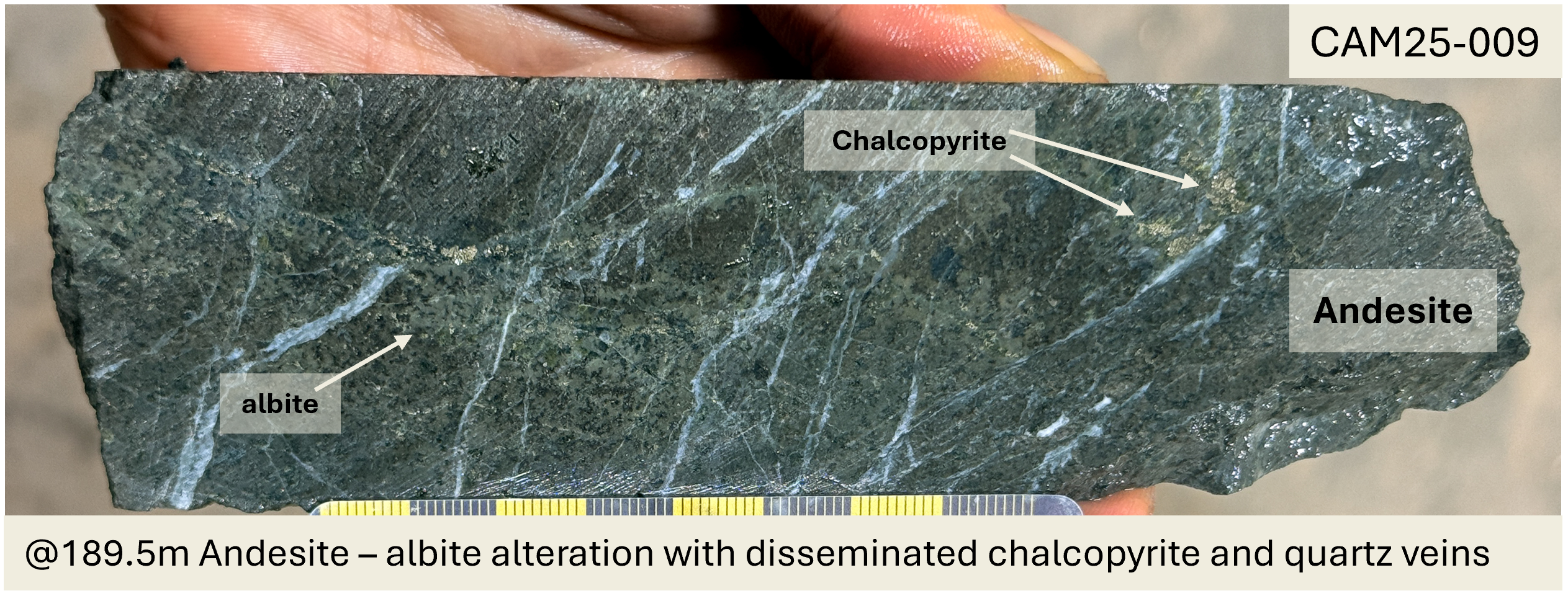 Figure 4: Photos of chalcopyrite mineralization and alteration within core from hole CAM25-009 at drilled depths of (top) 154.3 m and (bottom) 189.5 m respectively.
Drill Hole Cross-Section
A cross section for hole CAM25-009 is shown in Figure 5. Readers are cautioned that copper (Cu) values shown in the figures are based on single pXRF spot analyses measured at 1-meter intervals down the core string. These values should be interpreted as a qualitative indicator of the continuity and variance in copper mineralization but do not provide an accurate quantitative measurement of the copper concentration in the core.
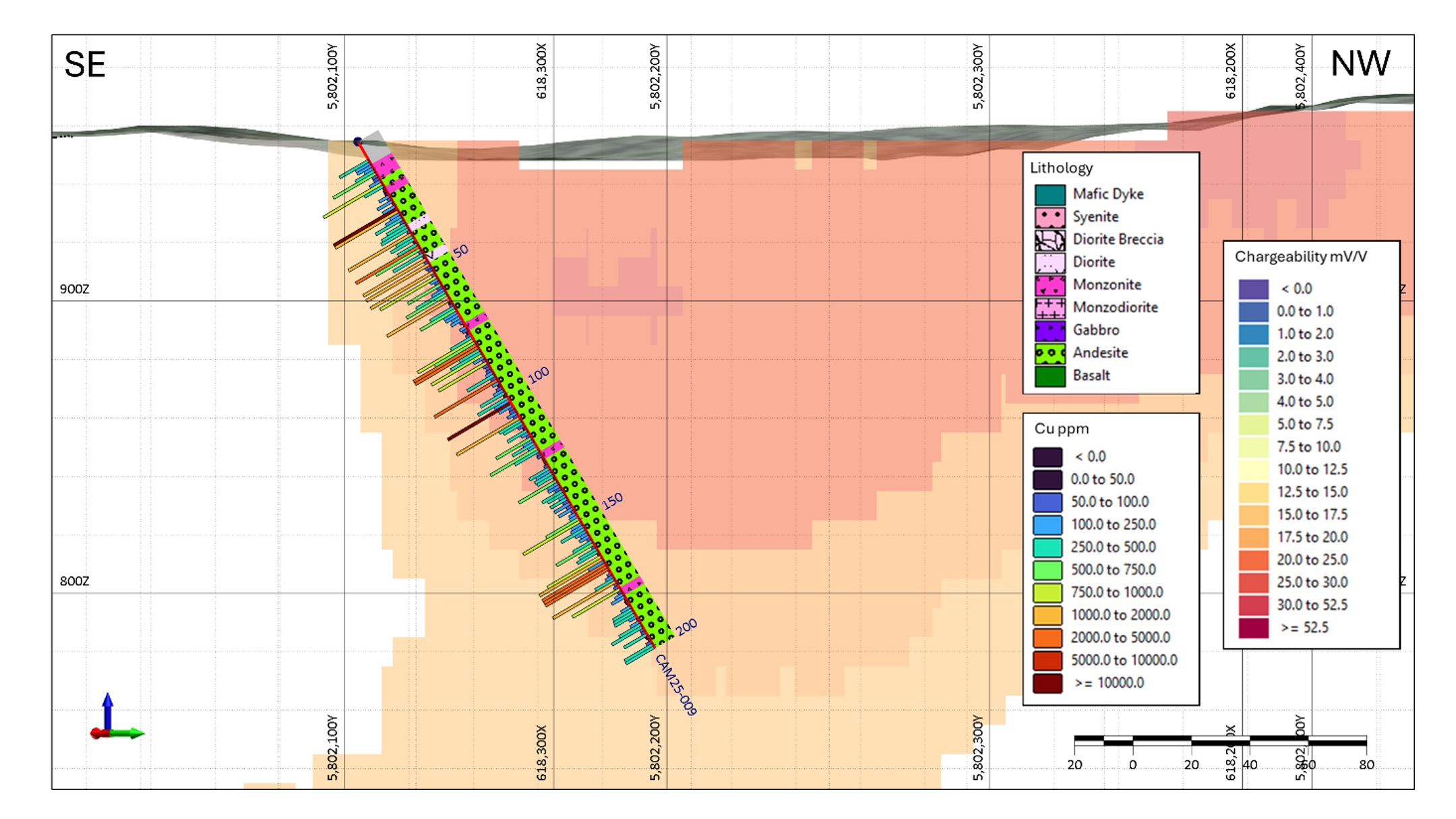 Figure 5: Cross-section of hole CAM25-009 that shows chargeability model, lithology on the right of the drill string, and copper (ppm) measured by pXRF on the left (histogram is capped at 1000 ppm) over a chargeability model from an IP data inversion . Section is 100 m thick and looks towards the southwest.
About the Camelot Property
The 2,646-hectare Camelot property lies approximately 65 km east of Williams Lake, B.C. within the Quesnel Terrane - home to multiple producing copper-gold and copper-molybdenum porphyry deposits, including the nearby Gibraltar and Mount Polley mines (Figure 1). Camelot is located 34 km southeast of Imperial Metal's Mount Polley and 13 km northeast of Vizsla Copper's Woodjam project.
The project area benefits from year-round road access and excellent regional infrastructure. Previous exploration workii,iii has outlined a 1,700 m x 500 m coincident chargeability-magnetic anomaly trending northeast-southwest beneath shallow till cover in an area that has not been previously drilled (Figure 3).
The property is centered on the Lemon Lake stock, a Late Triassic to Early Jurassic multi-phase pluton hosted in volcanic units of the Quesnel Terrane. The approximately 5 km wide pluton was formed by early phases of gabbro cut by younger monzonite, breccias, and late-stage syenitic dikes. Moderate K-feldspar and biotite alteration, as well as local pyrite-chalcopyrite mineralization, are primarily associated with monzonite intrusions. Zones of sericite-pyrite (or phyllic) alteration appear to be rare, consistent with the interpreted alkalic porphyry model assumed for the system.
Drill Hole Locations
The drill program is being conducted from drill pads constructed next to logging roads and fire breaks, with minimal surface disturbance. See Table 1 below for a summary of drill hole orientation and location.
Table 1: Drill hole collar locations and orientations for all 10 of the 2025 drill holes. All coordinates are in UTM NAD83 Zone 10.
Drill Hole ID | Target | Dip
(degrees) | Azimuth
(degrees) | Easting
(UTM)* | Northing
(UTM)* | Elevation
(m) | Total Depth
(m) |
CAM25-001 | Charlie | 340 | -60 | 616607 | 5801367 | 879 | 201 |
CAM25-002 | Charlie/Merlin | 160 | -55 | 616607 | 5801367 | 879 | 201 |
CAM25-003 | Lancelot | 290 | -50 | 616295 | 5800857 | 875 | 201 |
CAM25-004 | Galahad | 175 | -55 | 616574 | 5800508 | 869 | 102 |
CAM25-005 | Alpha | 175 | -50 | 617385 | 5802135 | 960 | 201 |
CAM25-006 | Alpha | 110 | -60 | 617259 | 5801864 | 925 | 201 |
CAM25-007 | Bravo | 45 | -55 | 617660 | 5801979 | 965 | 201 |
CAM25-008 | Alpha (sandworm) | 130 | -70 | 617089 | 5801655 | 875 | 201 |
CAM25-009 | Echo | 333 | -60 | 618350 | 5802109 | 954 | 201 |
CAM25-010 | Alpha | 300 | -75 | 617253 | 5801882 | 925 | 300 |
Land Acknowledgement
Prospect Ridge acknowledges that Camelot is situated within the traditional territories of the Williams Lake Indian Band, Xatsull First Nation, Whispering Pines/Clinton Indian Band, Northern Shuswap Tribal Council, and the Neskonlith Indian Band. The Company is committed to building positive, transparent, and mutually beneficial relationships with Indigenous communities founded on trust, respect, and open communication.
QA/QC (Quality Assurance/Quality Control)
Prospect Ridge's 2025 exploration program is managed by Equity Exploration Consultants Ltd. of Vancouver, B.C. The drill contractor is Dorado Drilling Ltd. of Vernon, B.C.
Core logging was done under the onsite supervision of professional geoscientists registered with EGBC and employed by Equity, a registered firm with EGBC.
Portable XRF analyses were done with an Olympus VANTA on spot samples every 1 m down the drill string. Spots were placed on representative pieces of core to avoid a selection bias of higher-grade samples. Occasional measurements of certified reference materials used for wet chemistry showed that pXRF analyses are accurate. Results were exported directly from the pXRF machine into 3D modelling software.
Qualified Person Statement
All technical information that forms the basis for the written disclosure in this press release, has been approved by Ron Voordouw, Ph.D., P.Geo., Director of Geoscience for Equity Exploration Consultants Ltd., who is an independent consultant to the Company, and a qualified person as defined under the terms of National Instrument 43-101.
About Prospect Ridge Resources Corp.
Prospect Ridge Resources Corp. is a British Columbia-based exploration and development company focused on critical metals and gold. Led by a seasoned management and technical team with over 100 years of combined mineral exploration experience, Prospect Ridge is advancing its north-central B.C. located Golden Horseshoe and Cariboo projects - high-potential copper-gold systems positioned within one of Canada's most under-explored yet geologically endowed mineral belts.
Contact Information
Prospect Ridge Resources Corp.
Mike Iverson - Chairman, Director
Email: mike@miverson.ca
Sources of Technical Information
(i). Baknes, M. J. 2023. Drilling Report on the Lemon Lake Project. B.C. Mines Branch Assessment Report Event No.5993800
(ii). Britton, R., 2021 2021 Geological - hand trenching, airborne Magnetic - VLF survey and petrological reports on the Lemon Lake property B.C. Mines Branch Assessment Report 39604
(iii). Bailey, D. 2012 Lemon Lake property Horsefly Induced Polarization and Magnetometer Survey B.C. Mines Branch Assessment Report 33088.
Neither the Canadian Securities Exchange nor its Regulation Services Provider (as that term is defined in the policies of the Canadian Securities Exchange) accepts responsibility for the adequacy or accuracy of this release.
This release includes certain statements and information ("FLI") that may constitute forward-looking information within the meaning of applicable Canadian securities laws. FLI relates to future events or future performance and reflect the current expectations or beliefs of the Company's management. Anything that is not historical fact is FLI. Generally, FLI can be, without limitation, identified by the use of forward-looking wording such as "plans", "intends", "believes", "expects", "anticipates" or "estimates", and statements or phrases that certain actions, events or results "may", "might", "could", "should" or "would" occur, and similar expressions. FLI is not historical fact, is made as of the date of this news release and includes, without limitation, statements and discussions of future plans, intentions, expectations, estimates and forecasts, and statements as to management's intentions and expectations with respect to, among other things, positive exploration results at the Camelot project. FLI involves numerous risks and uncertainties, and are based on assumptions, and actual results might differ materially from results suggested in any FLI. These risks and uncertainties include, among other things, the availability of financing to continue exploration activities, the availability and cost of qualified exploration personnel and service providers, and that future exploration results at the Camelot project will not be as anticipated. In making any FLI in this news release, the Company has applied several material assumptions, including without limitation, that future exploration results at the Camelot project will be as anticipated. Although management has endeavored to evaluate and use reasonable assumptions and to identify important factors that could cause actual results to differ materially from those contained in FLI, these assumptions may prove incorrect and there may be other factors that cause results not to be as intended, expected, anticipated or estimated. There can be no assurance that FLI will prove to be accurate, and actual results and future events could differ materially from those expressed in FLI. Accordingly, readers should not place undue reliance on FLI, and are further cautioned that reliance on such information may not be appropriate for other purposes. The Company does not undertake to update any FLI expressed or incorporated by reference herein, except in accordance with applicable securities laws. We seek safe harbor.
SOURCE: Prospect Ridge Resources Corp.
View the original press release on ACCESS Newswire

© 2026 Canjex Publishing Ltd. All rights reserved.