Results include 475 ft grading 0.25% CuT and 277 ft grading 0.33% CuT, both from surface
VANCOUVER, BC, Oct. 7, 2026 /CNW/ -- Edge Copper Corporation (TSX: EDCU) ("Edge Copper" or the "Company") reports assay results from eight additional diamond drill holes completed as part of its approximately 54,000-foot (ft) drilling program at the Company's 100%-owned Zonia Copper Project ("Zonia" or the "Project") in Arizona. The Company has now reported results from 53 holes in the current program.
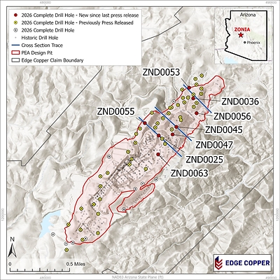
Eight additional holes confirm broad, near-surface oxide copper mineralization across the central and northern portions of Zonia and extend mineralization well below shallow historical drilling. Edge Copper will incorporate the results into its updated geological and resource models and the planned fourth-quarter 2026 Mineral Resource estimate.
Importantly, drilling to date has changed the Company's interpretation of Zonia's potential limits. The western lithologic contact and eastern fault were previously interpreted as possible boundaries to the mineralized system. Current drilling demonstrates that mineralization crosses both features, and neither is now considered a hard boundary.
"The latest drilling is doing more than confirming continuity within the PEA design pit; it is changing our understanding of the limits and scale potential of Zonia," said Gil Clausen, Chair and CEO of Edge Copper. "The western lithologic contact and eastern fault were previously treated as potential boundaries. The data now show mineralized zones extending across both features, so neither should be viewed as a hard limit to the system. These oxide results strengthen the geological model for the fourth quarter 2026 Mineral Resource update, and the forthcoming sulfide results will provide a much fuller view of Zonia's scale potential."
Drill Hole Highlights
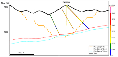
- ZND0045 returned 475 ft grading 0.25% CuT from surface, including 160 ft grading 0.30% total copper (CuT) from 70 ft, 30 ft grading 0.32% CuT from 280 ft and 35 ft grading 0.36% CuT from 380 ft.
- ZND0063 returned 277 ft grading 0.33% CuT from surface.
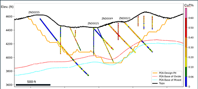
- ZND0055 returned 345 ft grading 0.25% CuT from 480 ft, including 210 ft grading 0.30% CuT from 605 ft, plus a separate 33 ft interval grading 0.19% CuT from 860 ft.
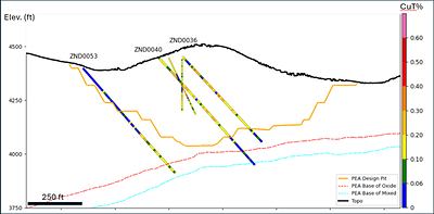
- Additional broad oxide intervals include: 401 ft grading 0.18% CuT in ZND0036, 391 ft grading 0.21% CuT in ZND0025 and 373 ft grading 0.23% CuT in ZND0047, including 31 ft grading 0.40% CuT.
The new drilling reinforces continuity across the central and northern deposit areas, from near surface to depth, while identifying higher-grade zones within a broad mineralized envelope. ZND0045 confirms near-surface oxide copper mineralization in the north-central portion of the PEA design pit. ZND0055 extends oxide mineralization well below shallow historical drilling along the northwest margin. See Figure 1 for drill-hole locations, Figures 2, 3 and 4 for cross-sections, and Appendix A for complete drill-hole details and significant intercepts.
More broadly, the program has materially changed Edge Copper's interpretation of the mineralized system. Earlier models treated the western lithologic contact and eastern fault as potential limits. Current drilling demonstrates that mineralization continues across both features. The geological model is being revised accordingly, increasing the area considered prospective for mineralization and future resource evaluation.
Program Outlook
Edge Copper is integrating the new assays with oriented core, geological logging, high-resolution core scans and sequential copper analyses to refine the geological and resource models. Current work is focused on:
- evaluating the continuity and geometry of the higher-grade intervals in ZND0045 and ZND0063;
- refining the oxide, mixed and sulfide boundaries and updating the geological model to reflect mineralization across the western lithologic contact and eastern fault;
- testing the mineralized system along strike, laterally, down dip and beyond previously interpreted limits;
- advancing metallurgical test work on representative mineralized material; and
- completing the technical work required to support an updated Zonia Mineral Resource estimate in the fourth quarter of 2026.
The Company expects to continue reporting results as assays, QA/QC review and geological interpretation are completed. The next drill-results release is expected to present the sulfide results from the current program and discuss their implications for the geometry and scale potential of the broader Zonia system.
QA/QC
All drill samples were collected under the supervision of the Company's geological staff in accordance with industry-standard quality assurance and quality control ("QA/QC") procedures. Samples are from HQ-diameter core. Core is scanned and logged before being cut; half-core samples are submitted for assay and the remaining material is retained at site for future reference.
The QA/QC program includes certified reference materials, blanks and duplicate samples inserted at regular intervals. Assay samples were collected directly from site by Skyline Assayers and Laboratories ("Skyline") and transported to Skyline's independent, accredited laboratory in Tucson, Arizona for preparation and analysis. Sample preparation included drying, crushing, splitting and pulverizing. Total copper was determined using Skyline's single-element method, consisting of three-acid digestion followed by atomic absorption spectroscopy determination.
Significant intervals were calculated using a 0.10% CuT cut-off. Drill core is oriented where possible. Most holes in the current program were drilled at inclinations of approximately -45 to -58 degrees and oriented toward the southeast; ZND0063 was drilled at -73 degrees toward the northwest. Drill orientations were selected to be broadly orthogonal to the interpreted strike and dip of the mineralized system, associated foliation and major bounding fault structures. Based on the current geological interpretation and drill geometry, the reported intervals are interpreted to represent approximate true thicknesses.
Qualified Person
The scientific and technical information contained in this news release has been approved by Patrick B. Redmond, Ph.D., P.Geo., a consultant to the Company, who is a Qualified Person as defined by National Instrument 43-101 - Standards of Disclosure for Mineral Projects. Dr. Redmond has verified the technical data supporting this news release by reviewing assay data, QA/QC results, drill logs, sampling records and drill hole collar/survey information.
About Edge Copper Corporation
Edge Copper Corporation is a copper-focused exploration and development company advancing its 100%-owned Zonia Copper Project in Arizona. Zonia is a past-producing heap-leach copper operation in Arizona's historic Walnut Grove mining district. With existing infrastructure, a 2026 Preliminary Economic Assessment and significant resource-expansion potential, Zonia is positioned as a U.S. copper development project. Edge Copper is advancing resource definition, metallurgy and technical studies through a disciplined approach to future development. For more information, please visit www.edgecopper.com.
Forward Looking Statements
This news release contains forward-looking information within the meaning of applicable securities laws. Forward-looking information includes, without limitation, statements regarding the Company's current and planned drilling; the interpretation and potential refinement of the structural model, deposit geometry, oxide copper envelope and oxide-sulfide boundary; the potential expansion of the Zonia mineralized system; the use of drilling results to support future Mineral Resource evaluation, potential resource classification changes and mining analysis; metallurgical test work; the anticipated timing, content and interpretation of the planned sulfide-results release; and the anticipated timing of an updated Mineral Resource estimate.
Forward-looking information is based on assumptions that management believes to be reasonable as of the date of this news release, including assumptions regarding assay turnaround times, drill performance, geological continuity, interpretation of drilling and scanning data, laboratory and metallurgical performance, availability of personnel and equipment, copper prices, financing, permitting and regulatory requirements, and the Company's ability to complete planned exploration and technical work.
Forward-looking information is subject to known and unknown risks, uncertainties and other factors that may cause actual results, performance or achievements to differ materially from those expressed or implied, including risks related to exploration and development, uncertainty in geological interpretation and Mineral Resource estimates, metallurgical recovery, commodity prices, financing, permitting, title, environmental matters, availability of personnel and equipment, and general economic and market conditions.
Statements regarding potential resource conversion, expansion, deposit limits or improved geological definition are conceptual and forward-looking and do not constitute a new or updated Mineral Resource estimate. There is no certainty that the current program will result in an expanded Mineral Resource, a change in resource classification or support any revised production profile. Readers are cautioned not to place undue reliance on forward-looking information. Except as required by applicable securities laws, the Company undertakes no obligation to update or revise such information.
PEA cautionary note: The PEA Design Pit shown in the figures is based on the Company's technical report titled National Instrument 43-101 Revised Technical Report 2026 Preliminary Economic Assessment Yavapai County, Arizona, USA, with a report date of April 7, 2026. The PEA is preliminary in nature and includes Inferred Mineral Resources that are considered too speculative geologically to have economic considerations applied to them that would enable them to be categorized as Mineral Reserves. There is no certainty that the PEA will be realized. Mineral Resources that are not Mineral Reserves do not have demonstrated economic viability.
APPENDIX A: Drill Hole Data
Table 1: Drill Hole Details
Hole ID | Easting (ft) | Northing
(ft) | Elevation (ft) | Azimuth (°) | Dip (°) | Total
Depth (ft) |
ZND0025 | 485025 | 1203510 | 4427 | 123 | -48 | 786 |
ZND0036 | 486552 | 1205152 | 4445 | 134 | -47 | 542 |
ZND0045 | 485802 | 1203891 | 4528 | 129 | -47 | 654 |
ZND0047 | 485368 | 1203555 | 4513 | 142 | -48 | 736 |
ZND0053 | 486371 | 1205626 | 4394 | 138 | -47 | 652 |
ZND0055 | 484409 | 1204055 | 4618 | 135 | -52 | 1171 |
ZND0056 | 486699 | 1204497 | 4342 | 145 | -46 | 392 |
ZND0063 | 484999 | 1202670 | 4507 | 315 | -73 | 1951 |
Notes: Coordinates are in Arizona State Plane (EPSG:2223). Total depth is rounded to the nearest foot. Actual hole dips are reported in the table; drill orientations were selected to be broadly orthogonal to interpreted foliation and major bounding fault structures. |
Table 2: Significant Intercept Table
Hole ID | From (ft) | To (ft) | Length (ft) | CuT% |
ZND0025 | 229 | 620 | 391 | 0.21 |
ZND0036 | 54 | 455 | 401 | 0.18 |
ZND0045 | 0 | 475 | 475 | 0.25 |
including | 70 | 230 | 160 | 0.30 |
including | 280 | 310 | 30 | 0.32 |
including | 380 | 415 | 35 | 0.36 |
ZND0047 | 2 | 375 | 373 | 0.23 |
including | 2 | 33 | 31 | 0.40 |
ZND0053 | 406 | 639 | 233 | 0.15 |
ZND0055 | 480 | 825 | 345 | 0.25 |
including | 605 | 815 | 210 | 0.30 |
ZND0055 | 860 | 893 | 33 | 0.19 |
ZND0056 | 0 | 116 | 116 | 0.17 |
ZND0063 | 0 | 277 | 277 | 0.33 |
Notes: From and To values are down-hole depths and are rounded to the nearest foot. Significant intervals were calculated using a 0.10% CuT cut-off. CuT means total copper. Reported intercepts are oxide copper mineralization, although some intervals may include minor mixed oxide-sulfide mineralization. The mixed oxide-sulfide transition zone at Zonia is generally narrow (see Figures 2,3 and 4). For this news release, the interpreted base of oxide mineralization was determined visually by the Company's geological team, assisted by scanning data. Final modelling of the oxide copper boundary is expected to incorporate sequential copper analyses and additional geological modelling in future technical studies. Drill core is oriented where possible. Most holes in the current program were drilled at inclinations of -45 to -58 degrees and oriented toward the southeast; ZND0063 was drilled at -73 degrees toward the northwest. Based on the current geological interpretation and drill geometry, the reported intervals are interpreted to represent approximate true thicknesses. Samples are from HQ-diameter core. Core is scanned and logged before being cut; half-core samples are submitted for assay and the remaining material is retained at site. Each assay batch includes duplicates, standards and blanks to monitor laboratory quality. Assays reported in this news release were completed by Skyline Assayers and Laboratories. |

SOURCE Edge Copper Corporation

 View original content to download multimedia: http://www.newswire.ca/en/releases/archive/October2026/07/c6856.html
For further information regarding Edge Copper: Letitia Wong, President, Telephone: +1 604 307-1128, Email: investor@edgecopper.com