Calgary, Alberta--(Newsfile Corp. - November 17, 2025) - Legacy Gold Mines Ltd. (TSXV: LEGY) (the "Company" or "Legacy Gold") is pleased to report assay results from six (6) additional Reverse Circulation (RC) drill holes from its 2025 surface exploration program on the Baner Property (the "Property"), in Idaho County, Idaho, USA, optioned by the Company. The latest results returned multiple intersections targeting the previously drilled Main Zone on the Property (see Figure 1-Plan View-2025 Baner Drill Results).
A total of 16 RC drill holes for 2,748 m (9,068 ft) were completed in the 2025 exploration program targeting the Orogrande shear structure, and the Company has now reported on eight (8) holes indicating a wide, low-grade, and large near-surface active gold plumbing system. The Company approached this drill program with financial prudency and made the decision to only sample sections where there were quartz veining or low sulphides. As assay results were received and results studied however, the Company has opted to sample all sections of all the holes drilled in this 2025 campaign.
"The initial results received to date of multiple wide intercepts indicating a robust system are encouraging and begin to test our theories and geological understanding of the Property and its full potential," said Mike Sutton, Legacy Gold's VP Exploration. "We have yet to receive results from the two highest priority holes, located in the vicinity of the strongest known mineralization on the Property, as well as the results from the gaps in sampling from the previously reported holes."
Highlights of Drilling:
- LG25-004 intersected 0.59 g/t Au over 71.6 m (235 ft), including 1.83 g/t Au over 1.5 m (5 ft) and 1.22 g/t Au over 1.5 m (5 ft), and 1.15 g/t Au over 18.3 m (60 ft), including 4.39 g/t Au over 1.6 m (5 ft) and 3.16 g/t Au over 1.5 m (5 ft), and ended in mineralization at a vertical depth of 203 m (665 ft); 96m (315 ft) was not sampled including immediately following the 3.16 g/t Au intercept (see Figure 2-Cross Section-LG25-003; 004).
- LG25-002 (previously released) intersected 0.46 g/t Au over 108.2 m (355 ft), including 1.00 g/t Au over 16.8 m (55 ft), 0.55 g/t Au over 24.4 m (80 ft), and 0.43 g/t Au over 44.2 m (145 ft), and ended in mineralization at a vertical depth of 120 m (see press release dated October 16, 2025).
- LG25-005 intersected 0.32 g/t Au over 88.4 m (290 ft), and 0.47 g/t Au over 29.0 m (95 ft), including 2.48 g/t Au over 1.5 m (5 ft) (see Figure 3-Cross Section-LG25-005).
- LG25-003 intersected 0.37 g/t Au over 57.9 m (190 ft), plus 2.8 g/t Au over 9.1 m (30 ft) including 12.95 g/t Au over 1.5 m (5 ft) and ended in mineralization at a vertical depth of 111.3 m (see Figure 2-Cross Section-LG25-003; 004).
- See Assay Results table below for additional intercepts.
2025 Baner Drill Program
The 2025 Baner Drill Program focused on testing for continuity of high-grade, and wide low-grade zones of gold mineralization with a new flatter, east dipping direction. This new interpretation is reflective of all the other deposits in the area, as opposed to the vertical dip assumed by previous operators, where mineralization is controlled by major structures that acted as conduits for gold bearing fluids. This would result in better continuity of mineralization, a far greater potential resource, and any strip ratio in a production scenario would be greatly decreased.
A total of 16 RC holes were completed as part of the 2025 Baner Drill Program, for a total of 2,748 m (9,068 ft) of drilling, targeting the Main Zone along the Orogrande shear structure.
The drill results received to date, although in its early stages, reinforce the theory of a highly prospective mineralized system on the Property. Preliminary results support the new interpretation of flat dipping veins, given the broad zones of mineralization encountered thus far.
Discussion of Results (LG25-003; 004; 005; 007; 008; 009)
As previously reported, the first two (2) drill holes returned multiple gold intersections from the east-west Baner vein system in the southern portion of the north-south Orogrande shear structure (see press release dated October 16, 2025). Drill hole LG25-002 returned 0.46 g/t Au over 108.2 m or 355 ft, including various non-sampled gaps totaling 19.8 m (65 ft) that were given a grade of zero. Three drill holes reported on today, LG25-003; 004; and 005, were drilled 350 m and 450 m north of the first two holes, following the north-south trending Main Zone. These drill holes returned similar, very wide, low-grade intersections indicating a large and active plumbing system. Drill holes LG25-007; 008; and 009 were drilled further to the north, with LG25-008; and 009 designed as short holes to specifically intersect a sub-vertical structure uncovered while developing some of the drill pads.
LG25-003 was designed to follow up on two previous intersections, the first of 20.8 g/t Au over 12.0 m (39.4 ft) including 48.98 g/t Au over 4.5 m (14.8 ft) in hole ICG2018-131 at surface in regolith (and noted poor core recovery). The second target area sits 20 m north of previously intersected 2.27 g/t Au over 11.0 m (36.1 ft) in hole ICG2018-141. LG25-003 intersected 2.8 g/t Au over 9.1 m (30 ft) in the upper zone including 12.95 g/t Au over 1.5 m (5 ft), plus 0.37 g/t Au over 57.9 m (190 ft) in the lower zone, and ended in mineralization at a vertical depth of 111.3 m. Refer to image (Figure 2-Cross Section-LG25-003; 004).
LG25-004 intersected 1.15 g/t Au over 18.3 m (60 ft) including 4.39 g/t Au over 1.5 m (5 ft) and 3.16 g/t Au over 1.5 m (5 ft) in the upper zone. From 33.5 m up to 129.5 m depth was not sampled, but given the results and surrounding intercepts, will look to be sampled along with certain other non-sampled gaps in this program. LG25-004 also intersected 0.59 g/t Au over 71.6 m (235 ft), including 1.83 g/t Au over 1.5 m (5 ft) and 1.22 g/t Au over 1.5 m (5 ft), in the lower zone. LG25-004 ended in mineralization at a vertical depth of 203 m (665 ft). LG25-004 was designed to drill close to a previously reported intersection of 20.8 g/t Au over 12.0 m (39.4 ft) including 49.0 g/t Au over 4.5 m (14.8 ft) in hole ICG2018-131 at surface in highly oxidized rock, where poor core recovery was obtained. , and to intersect two other zones 12 m and 31 m below and south of 0.33 g/t Au over 22.8 m (74.8 ft) (middle zone) and 0.24 g/t Au over 28.5 m (93.5 ft) (lower zone) in hole ICG2018-131. Refer to image (Figure 2-Cross Section-LG25-003; 004).
LG25-005 was designed to drill a 100-metre gap between strong mineralization to the north and 37 metres from weaker mineralization to the south. It intersected 0.32 g/t Au over 88.4 m (290 ft), including 2.63 g/t Au over 1.5 m (5 ft) and 0.98 g/t Au over 1.5 m (5 ft) and 0.90 g/t Au over 1.5 m (5 ft), plus 0.47 g/t Au over 29.0 m (95 ft), including 2.48 g/t Au over 1.5 m (5 ft) and 1.47 g/t Au over 1.5 m (5 ft). Refer to image (Figure 3-Cross Section-LG25-005).
Hole LG25-007 is a steep hole that was designed to intersect multiple intersections in hole ICG-2018-161, located 36 metres to the south of LG25-007 and includes 4.8 g/t over 5.9 m (19.4 ft), 1.5 g/t over 10.2 m (33.5 ft), and 3.7 g/t over 5.3 m (17.4 ft). LG25-007 intersected 13 zones of narrow mineralization with the highest being 2.7 g/t over 1.5 m (5 ft), and 1.16 g/t over 3.0 (10 ft), where there was no sampling for a total of 13.2 m (43.3 ft), between 51.8 m (169.9 ft) and 65.5 m (215.0 ft), and no sampling for a total of 22.9 m (75.1 ft), between 76.2 m (250.0 ft) to 99.1 m (325.1 ft). Refer to image (Figure 4-Cross Section-LG25-007; 008; 009).
LG25-008 and LG25-009 were short holes drilled west to east, specifically to intersect a sub-vertical structure that was uncovered when developing some of the drill pads. The best result was from LG25-008 which intersected 1.57 g/t Au over 3.00 m (10 ft) which could line up with the mineralized structure. Refer to image (Figure 4-Cross Section-LG25-007; 008; 009).
Note 1: These intercepts were drilled by Idaho Champion Gold, see Technical Report (defined below) for additional information.
Table 1: 2025 Baner Drill Program - Assay Results
| Hole ID | From | To | Intercept | From | To | Intercept | Au |
| (m) | (m) | (m) | (ft) | (ft) | (ft) | (g/t) |
| LG25-003 | 0.0 | 1.5 | 1.5 | 0.0 | 5.0 | 5.0 | 0.20 |
| 13.7 | 22.9 | 9.2 | 45.0 | 75.0 | 30.0 | 2.80 |
| incl. | 15.2 | 16.8 | 1.6 | 50.0 | 55.0 | 5.0 | 12.95 |
| 29.0 | 30.5 | 1.6 | 95.0 | 100.0 | 5.0 | 0.35 |
| 35.1 | 38.1 | 3.0 | 115.0 | 125.0 | 10.0 | 0.23 |
| 47.2 | 105.2 | 58.0 | 155.0 | 345.0 | 190.0 | 0.37 |
| 108.2 | 109.7 | 1.5 | 355.0 | 360.0 | 5.0 | 0.27 |
| LG25-004 | 3.0 | 4.6 | 1.6 | 10.0 | 15.0 | 5.0 | 0.26 |
| 6.1 | 9.1 | 3.0 | 20.0 | 30.0 | 10.0 | NS |
| 15.2 | 33.5 | 18.3 | 50.0 | 110.0 | 60.0 | 1.15 |
| incl. | 27.4 | 29.0 | 1.6 | 90.0 | 95.0 | 5.0 | 4.39 |
| incl. | 32.0 | 33.5 | 1.5 | 105.0 | 110.0 | 5.0 | 3.16 |
| 33.5 | 129.5 | 96.0 | 110.0 | 425.0 | 315.0 | NS |
| 131.1 | 202.7 | 71.6 | 430.0 | 665.0 | 235.0 | 0.59 |
| incl. | 172.2 | 173.7 | 1.5 | 565.0 | 570.0 | 5.0 | 1.83 |
| incl. | 178.3 | 179.8 | 1.5 | 585.0 | 590.0 | 5.0 | 1.22 |
| LG25-005 | 4.6 | 33.5 | 28.9 | 15.0 | 110.0 | 95.0 | 0.47 |
| incl. | 15.2 | 16.8 | 1.6 | 50.0 | 55.0 | 5.0 | 1.47 |
| incl. | 24.4 | 25.9 | 1.5 | 80.0 | 85.0 | 5.0 | 2.48 |
| 44.2 | 45.7 | 1.5 | 145.0 | 150.0 | 5.0 | 0.25 |
| 59.4 | 147.8 | 88.4 | 195.0 | 485.0 | 290.0 | 0.32 |
| incl. | 70.1 | 71.6 | 1.5 | 230.0 | 235.0 | 5.0 | 0.90 |
| incl. | 126.5 | 128.0 | 1.5 | 415.0 | 420.0 | 5.0 | 2.63 |
| incl. | 143.3 | 144.8 | 1.5 | 470.0 | 475.0 | 5.0 | 0.98 |
| LG25-007 | 0.0 | 3.1 | 3.1 | 0.0 | 10.0 | 10.0 | NS |
| 4.6 | 6.1 | 1.5 | 15.0 | 20.0 | 5.0 | 0.29 |
| 9.1 | 10.7 | 1.6 | 30.0 | 35.0 | 5.0 | 0.20 |
| 15.2 | 16.8 | 1.6 | 50.0 | 55.0 | 5.0 | 0.27 |
| 22.9 | 24.4 | 1.5 | 75.0 | 80.0 | 5.0 | 1.25 |
| 35.1 | 36.6 | 1.5 | 115.0 | 120.0 | 5.0 | 0.23 |
| 41.1 | 44.2 | 3.1 | 135.0 | 145.0 | 10.0 | 0.29 |
| 50.3 | 51.8 | 1.5 | 165.0 | 170.0 | 5.0 | 2.70 |
| 51.8 | 65.5 | 13.7 | 170.0 | 215.0 | 45.0 | NS |
| 67.1 | 68.6 | 1.5 | 220.0 | 225.0 | 5.0 | 0.49 |
| 76.2 | 99.1 | 22.9 | 250.0 | 325.0 | 75.0 | NS |
| 99.1 | 100.6 | 1.5 | 325.0 | 330.0 | 5.0 | 0.40 |
| 103.6 | 109.7 | 6.1 | 340.0 | 360.0 | 20.0 | NS |
| 109.7 | 112.8 | 3.1 | 360.0 | 370.0 | 10.0 | 1.16 |
| 114.3 | 129.5 | 15.2 | 375.0 | 425.0 | 50.0 | NS |
| 131.1 | 132.6 | 1.5 | 430.0 | 435.0 | 5.0 | 0.59 |
| 135.6 | 137.2 | 1.6 | 445.0 | 450.0 | 5.0 | 0.20 |
| 138.7 | 143.3 | 4.6 | 455.0 | 470.0 | 15.0 | NS |
| 147.8 | 153.9 | 6.1 | 485.0 | 505.0 | 20.0 | 0.23 |
| 157.0 | 158.5 | 1.5 | 515.0 | 520.0 | 5.0 | 0.22 |
| 160.0 | 163.1 | 3.1 | 525.0 | 535.0 | 10.0 | 0.37 |
| 175.3 | 181.4 | 6.1 | 575.0 | 595.0 | 20.0 | NS |
| LG25-008 | 0.0 | 7.6 | 7.6 | 0.0 | 25.0 | 25.0 | NS |
| 12.2 | 15.2 | 3.0 | 40.0 | 50.0 | 10.0 | 1.57 |
| 35.1 | 38.1 | 3.0 | 115.0 | 125.0 | 10.0 | 0.51 |
| 57.9 | 59.4 | 1.5 | 190.0 | 195.0 | 5.0 | 0.27 |
| 62.5 | 71.6 | 9.1 | 205.0 | 235.0 | 30.0 | NS |
| LG25-009 | 0.0 | 29.0 | 29.0 | 0.0 | 95.0 | 95.0 | NS |
| 56.4 | 57.9 | 1.5 | 185.0 | 190.0 | 5.0 | 0.30 |
Notes: NS= not sampled; Composite intersections are calculated using a 0.2 g/t cutoff for gold with 10 m internal dilution. True widths are calculated to 70%-90%. Only visually altered samples were sent for assay; assaying was only for gold.
Table 2: Drill Hole Coordinates
| Hole ID | Azimuth | Dip | Northing | Easting | Total Depth (m) | Total Depth
(ft) |
| LG25-003 | 300 | -45 | 615388 | 5069476 | 111.300 | 365.1 |
| LG25-004 | 252 | -60 | 615384 | 5069487 | 202.700 | 664.9 |
| LG25-005 | 270 | -45 | 615385 | 5069634 | 153.930 | 504.9 |
| LG25-007 | 234 | -85 | 615378 | 5069820 | 181.350 | 594.8 |
| LG25-008 | 65 | -45 | 615355 | 5069809 | 71.630 | 234.9 |
| LG25-009 | 175 | -50 | 615337 | 5069798 | 68.600 | 225.0 |
Geology and Mineralization
The belt of mineralization that traces through the Elk City and Orogrande mining districts is known as the Orogrande Shear Zone ("OSZ"), and is estimated to be between 100-200 m wide, with a general NNE trend. Gold mineralization occurs along this zone in numerous prospects and small historic mines. Most of the mineralization appears to be along Reidel shear structures that cross over between two bounding major north-south structures along the OSZ. In general, higher grade historical mining was undertaken on narrow zones of strong sericite-silica-carbonate alteration and quartz veins. Intrusion-related structurally controlled mineralization has been suggested previously. At the Property, the predominate host rock is quartzite, with some biotite gneiss also present.
Review by Qualified Person
Mr. Mike Sutton, P.Geo., Director and VP of Exploration of the Company, is the Qualified Person, as defined under National Instrument 43-101 - Standards of Disclosure for Mineral Projects, who reviewed and approved scientific and technical disclosure in this press release. The Qualified Person has not reviewed the mineral tenure, nor independently verified the legal status and ownership of the Property or any underlying property agreements.
Drilling and Sampling: Drilling was carried out using a Foremost built tracked MPD1500 RC drilling unit, the rig has jacks and a blade and is capable of working on small pads on steep ground to minimize ground prep. Drilling to final hole depth was completed using 4-inch pipe and a 51/4 inch bit. Holes were cased down to approximately 25 ft with 8-inch steel casing drifted-in using a tricone bit. RC drilling uses a hammer and at depth below groundwater level a tricone bit was sometimes used.
RC drilling was done wet, with water actively pumped down the hole, mixing with pulverised sample, and coming through the cyclone to an 8-compartment rotary fan wet splitter. Each compartment can be shut off giving control of the amount of split material. Rotary splitter was setup with 1:2 split, with the half split going into a calico bag housed in a bucket for an assay sample. The remainder of the sample falls to the ground and runs into the sump. Each assay sample is for a 1.52 m (5 ft) interval. The splitter and cyclone are flushed every 4 samples or upon noticing a change in color. Chips were collected from the splitter reject and put into chip trays for reference.
Bar-coded Calico bags are pre-labelled, and a corresponding sequential from-to depth is pre-recorded in a spreadsheet. Quality control samples are included in the numerical sequence with B, S, or D designations for blanks, standards, and duplicates. The drilling team is responsible for changing the bags and regular company supervision and cross-checks on sample numbers and intervals avoids sample mix-ups. Filled sample bags are laid on the ground in order so a visual check can be easily performed when collecting samples.
Samples are dispatched to the ALS Global prep-lab in Twin Falls, Idaho, USA with final gold assays completed in Reno, Nevada. The lab has ISO/IEC 17025 accreditation. All samples are assayed for gold by Fire Assay, with gravimetric finish. The Company's QA/QC program includes the regular insertion of blanks and standards into the sample shipments. Duplicates were prepared on-site with a riffle splitter. Standards, blanks and duplicates are inserted at approximately one per 15 samples.
About Legacy Gold Mines Ltd.
The Company is a Canadian based gold exploration and development company that is listed on the TSX Venture Exchange under the symbol "LEGY". The Company holds an option to acquire a 100% undivided interest in and to the mineral claims comprising the Property located in Idaho County, Idaho, USA.
Additional information about the Company and the Property is available on SEDAR+ at www.sedarplus.ca under the Company's profile, including a technical report titled "NI 43-101 Technical Report on the Baner Project, Idaho County, Idaho, USA", dated effective August 1, 2024, prepared by Steven A. Osterberg, Ph.D., P.G. (the "Technical Report").
CAUTIONARY STATEMENT REGARDING FORWARD-LOOKING INFORMATION: This press release includes certain "forward-looking statements" under applicable Canadian securities legislation. Forward-looking statements include, but are not limited to, timing and completion of any exploration, drilling and work programs on the Property, estimates of mineralization from drilling, sampling and geophysical surveys, geological information projected from drilling and sampling results and the potential quantities and grades of the target zones, the potential for minerals and/or mineral resources and reserves, and statements regarding the plans, intentions, beliefs, and current expectations of the Property and the Company that may be described herein. Forward-looking statements consist of statements that are not purely historical, including any statements regarding beliefs, plans, expectations or intentions regarding the future. Such information can generally be identified by the use of forwarding-looking wording such as "may", "expect", "estimate", "anticipate", "intend", "believe" and "continue" or the negative thereof or similar variations. Readers are cautioned not to place undue reliance on forward-looking statements, as there can be no assurance that the plans, intentions or expectations upon which they are based will occur.
By their nature, forward-looking statements involve numerous assumptions, known and unknown risks and uncertainties, both general and specific, that contribute to the possibility that the predictions, estimates, forecasts, projections and other forward-looking statements will not occur. These assumptions, risks and uncertainties include, among other things, the state of the economy in general and capital markets in particular, as well as those risk factors discussed in the Filing Statement of the Company dated effective September 19, 2024 or referred to in the Company's annual Management's Discussion and Analysis for the year ended December 31, 2024 and the period ended September 30, 2025 available at www.sedarplus.ca, many of which are beyond the control of the Company. Forward-looking statements contained in this press release are expressly qualified by this cautionary statement.
The forward-looking statements contained in this press release are made as of the date of this press release. Except as required by law, the Company disclaims any intention and assumes no obligation to update or revise any forward-looking statements, whether as a result of new information, future events or otherwise. Additionally, the Company undertakes no obligation to comment on the expectations of, or statements made by, third parties in respect of the matters discussed above.
Neither the TSX Venture Exchange nor its Regulation Service Provider (as that term is defined in the policies of the TSX Venture Exchange) accepts responsibility for the adequacy or accuracy of this release.
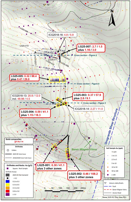
Figure 1: Plan View-2025 Baner Drill Results
To view an enhanced version of this graphic, please visit:
https://images.newsfilecorp.com/files/10544/274790_f6aee674d43f6b0f_002full.jpg
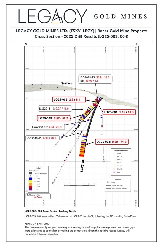
Figure 2: Cross Section (Looking North)- LG25-003; 004
To view an enhanced version of this graphic, please visit:
https://images.newsfilecorp.com/files/10544/274790_f6aee674d43f6b0f_003full.jpg
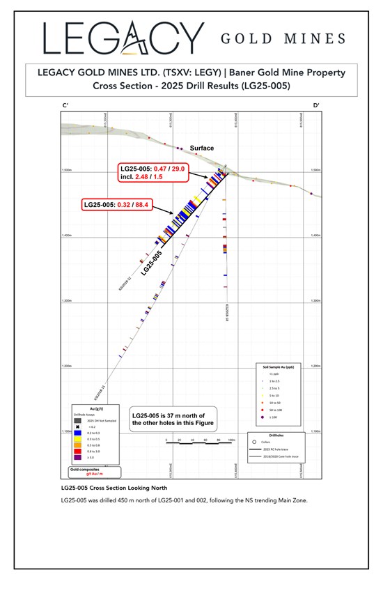
Figure 3: Cross Section (Looking North)- LG25-005
To view an enhanced version of this graphic, please visit:
https://images.newsfilecorp.com/files/10544/274790_f6aee674d43f6b0f_004full.jpg
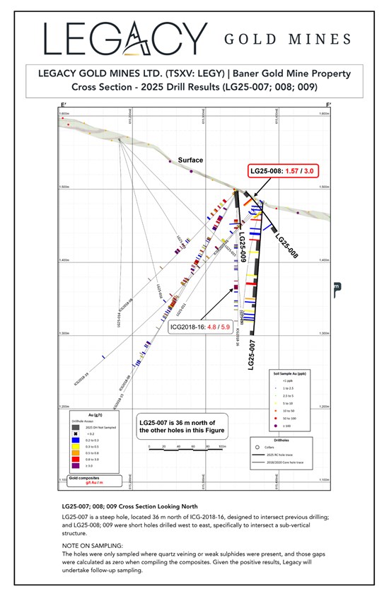
Figure 4: Cross Section (Looking North)- LG25-007; 008; 009
To view an enhanced version of this graphic, please visit:
https://images.newsfilecorp.com/files/10544/274790_f6aee674d43f6b0f_005full.jpg

To view the source version of this press release, please visit https://www.newsfilecorp.com/release/274790

© 2026 Canjex Publishing Ltd. All rights reserved.