Thunder Bay, Ontario--(Newsfile Corp. - July 29, 2026) - Metals Creek Resources Corp. (TSXV: MEK) (OTC Pink: MCREF) (FSE: M1C1) (the "Companies" or "Metals Creek") and Benton Resources Inc. (TSXV: BEX) (the "Companies" or "Benton") are pleased to announce the commencement of two large scale regional soil gas programs (See New Release: June 23, 2026) at Parson's Pond and Smoking Gun Hydrogen-Helium projects. Rudy Willick of Rudiger Re-Chem from Neuanlage, Saskatchewan will oversee execution of these programs. Rudy is a well-known scientist in the Hydrogen-Helium space, having completed significant targeting for such companies as MAXX Power.
The soil sampling program is expected to see the collection of approximately 650 to 750 samples and is expected to take 2 to 3 weeks to finalize the field portion of this program. After all samples are collected, Rudiger Re-Chem will analyze all sample vials for Hydrogen, Helium, Neon, CO2 and C1-C4 Hydrocarbons. All final data and a summary report will be supplied to the companies.
Deer Lake Basin Property
The Smoking Gun Project contains the Mills No.1 drill hole in the Southwest, in addition to the Claybar No. 3 drill hole (Figure 1) to the NE. The Companies are excited about this new acquisition, as recent research from historical data has revealed highly anomalous helium with values up to 8,900 parts per billion (ppb) (see Table 1) in water collected from a historic drill hole (79-67). This hole is located approximately 11.8 km from a drill hole (Mills No. 1) that encountered high pressure gas that flowed for a minimum of 12 months in a basin prospective for uranium-thorium. In addition, several mentions of gas are noted in Claybar No. 3, located 32 km to the NE of drill hole 79-67. These 3 holes potentially indicates an expansive system with favorable geological conditions for the generation and entrapment of gas.
Ref: https://gis.gov.nl.ca/mods/ModsCard.asp?NMINOString?temp=n&NMINOString=012H/03/Btm002
Parson's Pond Property
At Parson's Pond, the Companies large land position covers a faverable large basin (see Figure 2) where research confirmed the presents of gas in several historical drill logs located 14.2 km apart, significant gas hits observed C1 methane gas levels reaching 72%. The area is underlain by thrust faulted rocks of the Humber Arm Supergroup. Drill logs indicate unique sedimentary units composed of shales along with sandstones, containing fragments of serpentine and chrome. Of particular interest is the presence of the mineral glauconite, which, combined with these geological indicators, suggests a highly prospective environment for white hydrogen (natural hydrogen) to form within the basin. The presence of such high concentrations of methane alongside hydrogen indicators suggests a potentially active gas system within the basin. In addition, surface areas have been noted to vent gas within the project boundaries.
(Ref. NALCOR ENERGY – OIL AND GAS INC FINAL WELL REPORT For Nalcor Energy et al SEAMUS #1 https://www.gov.nl.ca/em/files/publications-energy-nalcorseamusfwr.pdf and NALCOR ENERGY – OIL AND GAS INC FINAL WELL REPORT For Nalcor Energy et al Finnegan #1 https://www.gov.nl.ca/em/files/FinniganFWR.pdf).
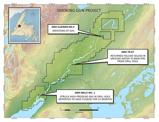
Figure 1: Smoking Gun Project Location Map
To view an enhanced version of this graphic, please visit:
https://images.newsfilecorp.com/files/943/307011_c97ba046b4b3e8e4_002full.jpg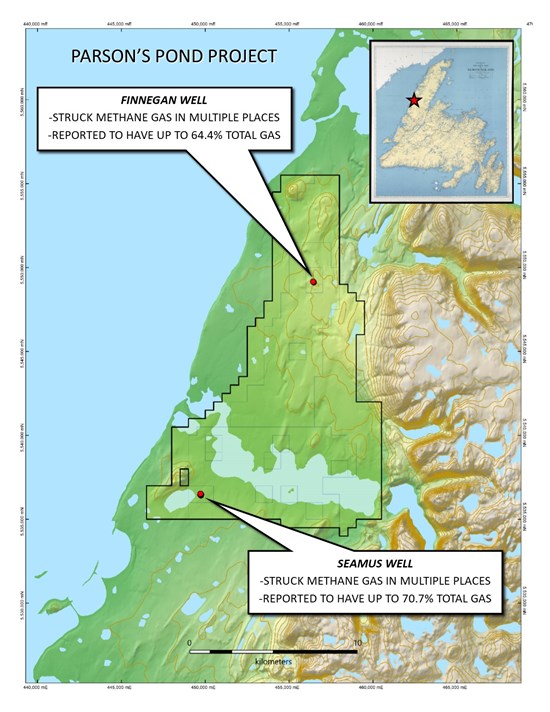
Figure 2: Parson's Pond Project Location Map
To view an enhanced version of this graphic, please visit:
https://images.newsfilecorp.com/files/943/307011_c97ba046b4b3e8e4_003full.jpg
Survey Parameters
The geochemical survey program begins with the preparation of sample vials and replacing the septa in the probes. The vials are evacuated to an absolute pressure of 20 pascals so that a sample extracted by a syringe is not contaminated with residual ambient air. A cordless rotary drill is used to drive a hollow probe of stainless steel to an average depth of about 1 meter to avoid barometric pumping which can affect gas concentrations in soil. Once the probe is purged of ambient air, a 30cc sample is extracted and injected through the septum of a 12cc vial. Other operations at the sampling site are the recording of coordinates by GPS and recording of sample numbers on the box cover. To avoid Hydrogen Artefacts in analysis, Rudiger Re-Chem utilizes a proprietary probe as well as detailed field notes for soil-gas surveys. The samples are shipped to Rudiger Re-Chem's lab in Saskatoon for analysis by a state-of the art Gas Chromatographs.
Hydrogen and Helium Demand
Hydrogen and helium have seen a significant increase in demand, with more expected in the future. Hydrogen is used as a fuel and a chemical building block, it helps create fertilizer for food, refines the gasoline in your car, and is increasingly being used to power clean trucks and ships as well as fuel for rocket propulsion for the launching of satellites. Helium is the world's ultimate cooler; its super-cold properties are essential for keeping MRI machines running and making the computer chips found in your phone and laptop. AI-driven chip manufacturing is the primary growth engine for helium. Helium keeps our most advanced technology and medical equipment functioning.
In the neighboring province of Nova Scotia, companies such as Quebec Innovative Metals Corp are having success in the search for Natural Hydrogen. This success has generated further exploration in similar geological environments to that of the projects mentioned above.
Please note that the presence of gas or methane on these staked projects or gas discovered on adjacent properties does not guarantee the presence of hydrogen or helium. Further studies are required to validate their presence.
About Metals Creek Resources Corp.
Metals Creek Resources Corp. is a junior exploration company incorporated under the laws of the Province of Ontario, is a reporting issuer in Alberta, British Columbia and Ontario, and has its common shares listed for trading on the Exchange under the symbol "MEK". Metals Creek has earned a 50% interest in the Ogden Gold Property including the former Naybob Gold mine, located 6 km south of Timmins, Ontario and has an 8 km strike length of the prolific Porcupine-Destor Fault (P-DF).
Additional information concerning the Company is contained in documents filed by the Company with securities regulators, available under its profile at www.sedarplus.ca.
Neither the TSX Venture Exchange nor its Regulation Services Provider (as that term is defined in the policies of the TSX Venture Exchange) accepts responsibility for the adequacy or accuracy of this release.
To view the source version of this press release, please visit https://www.newsfilecorp.com/release/307011

© 2026 Canjex Publishing Ltd. All rights reserved.