Melbourne, Australia and Vancouver, British Columbia--(Newsfile Corp. - June 30, 2026) - Mithril Silver and Gold Limited (TSXV: MSG) (ASX: MTH) (OTCQB: MTIRF) ("Mithril" or the "Company") is pleased to announce an upgraded Mineral Resource Estimate (MRE) for the Target 1 deposit at its flagship Copalquin Project in Durango State, Mexico.
After approximately 60,000 metres of drilling, 204 drill holes for an overall Target 1 discovery cost of less than US$20 per ounce of gold equivalent (AuEq), Mithril has developed a high quality and predictive geological model that clearly defines the controls on mineralisation, resulting in high resource confidence and continuity.
Unlike a purely geological estimate, the upgraded MRE has been constrained using preliminary mining shapes and incorporates expected mining dilution, providing a more realistic representation of the material that could ultimately form a mine plan. By accounting for practical mining conditions at the resource stage, the estimate provides a stronger foundation for future mine planning, engineering studies and economic evaluation, and represents an important step in de-risking the Target 1 as it advances toward development.
Highlights
- Significant resource upgrade with total constrained and diluted Indicated and Inferred resources of 343 koz gold + 8.479 Moz silver (464 koz AuEq) and 103 koz gold + 3.398 Moz silver (151 koz AuEq), respectively. Indicated totals 3.391 Mt grading 3.15 g/t gold and 77.8 g/t silver (diluted) and Inferred totals 1.436 Mt grading 2.23 g/t gold and 73.6 g/t silver (diluted). See Table 2 for full details
- 196% increase in higher-confidence indicated gold and silver compared to previous MRE.
- 75% of total gold and silver now classified as indicated
- Resource constrained within preliminary underground mining shapes and incorporates expected mining dilution, providing a more realistic basis for future engineering and economic studies
- High confidence resource, remains open along strike and at depth with multiple opportunities for expansion
- Overall Target 1 MRE discovery cost of less than US$20 per ounce AuEq from approximately 60,000 metres of drilling in 204 drill holes
- Geological insights from Target 1 are being applied across multiple high-grade targets within the broader Copalquin epithermal system
The following Table 1 provides the highlighted base case for undiluted mineralisation reporting within the underground mining shapes (mine stope optimiser - MSO) at a cut-off grade of 1.5 g/t AuEq plus sensitivities to gold prices.
The MRE for Target 1 (Table 2) was generated from the highlighted base case in Table 1 assuming bulk underground mining method (long hole open stoping - LHOS) with mining widths averaging approximately 4 metres as presented on a diluted basis in Table 2. The MSO work identified areas where more selective underground mining methods such as cut and fill (higher cost than LHOS) could be utilised to reduce dilution and increase mined grades. The difference between the undiluted grade of 6.85 g/t AuEq (Table 1 Indicated base case) and the diluted grade of 4.26 g/t AuEq (Table 2, Total Indicate Target 1 MRE) reflects this conservative mining dilution assumption whereby lower grade mineralisation surrounding the high grade core would be extracted within geometry of a minable shape adding more tonnes and ounces at a lower average grade. More detailed mining study work will fully assess the mining methods across the Target 1 MRE.
"This resource upgrade is about much more than adding ounces. We now have a resource where three-quarters of the contained metal sits in the higher-confidence Indicated category, constrained within practical underground mining shapes and incorporating expected mining dilution," said John Skeet, Managing Director and CEO. "That gives us a resource that is directly applicable to mine planning rather than simply a geological inventory. Combined with a discovery cost of less than US$20 per gold equivalent ounce and an underlying predictive geological model that continues to identify new mineralisation, we believe Target 1 has become one of the highest-quality pre-development underground gold-silver resources in Mexico."
Webinar - Join Mithril management for live online seminar reviewing the most recent MRE and company update.
Date and Time: Pacific Time June 30, 2026 3:30pm, Aust Eastern Time, July 1, 2026 8:30 am
Where: https://6ix.com/event/mithril-silver-and-gold-copalquin-project-update
Table 1 Gold price sensitivity to constraining shapes, reported at 1.5 g/t AuEq cut-off (constrained and undiluted)
| Au Prices | Classification | Tonnes | Gold | Silver | Gold Eq. | Gold | Silver | Gold Eq. |
| (USD) |
| (kt) | (g/t) | (g/t) | (g/t) | (koz) | (koz) | (koz) |
| 2,700 | Ind | 1,888 | 5.28 | 126.1 | 7.08 | 321 | 7,654 | 430 |
| Inf | 831 | 3.46 | 113.7 | 5.08 | 92 | 3,038 | 136 |
| 3,000 | Ind | 1,941 | 5.18 | 124.2 | 6.96 | 323 | 7,752 | 434 |
| Inf | 863 | 3.39 | 111.7 | 4.98 | 94 | 3,099 | 138 |
| 3,300 | Ind | 1,990 | 5.10 | 122.4 | 6.85 | 326 | 7,832 | 438 |
| Inf | 900 | 3.32 | 109.1 | 4.87 | 96 | 3,155 | 141 |
| 3,500 | Ind | 2,038 | 5.01 | 120.9 | 6.74 | 329 | 7,922 | 442 |
| Inf | 923 | 3.27 | 107.5 | 4.81 | 97 | 3,189 | 143 |
| 4,000 | Ind | 2,074 | 4.96 | 119.7 | 6.67 | 330 | 7,984 | 445 |
| Inf | 949 | 3.23 | 105.9 | 4.74 | 98 | 3,233 | 145 |
Notes to Table 1:
- The Table presents the results of a sensitivity analysis by varying gold prices on AuEq block model values and reports an undiluted tonnage, grade and metal content contained within the mining shapes. The scenarios as presented are not considered statement of mineral resources or reserves, and do not have demonstrated economic viability.
- AuEq calculated using metal prices of USD $3,300/oz Au and $50/oz Ag where AuEq g/t = Au g/t + (Ag g/t x (Au price/Ag price) x (Ag recovery/Au recovery)) with metallurgical recoveries of 96% Au and 91% Ag from metallurgical test work on Target 1 composite samples1. An AuEq cut-off grade of 1.5 g/t was selected after applying 95% mining recovery and 5% dilution factors to the metal price and recovery values.
Table 2 Upgraded Copalquin Target 1 Mineral Resource Estimate (underground mining shape constrained & diluted)
Target 1
Area | Class | Tonnes | Gold | Silver | Gold Eq. | Gold | Silver | Gold Eq. |
|
| (kt) | (g/t) | (g/t) | (g/t) | (koz) | (koz) | (koz) |
| El Refugio | Ind | 2,557 | 3.38 | 73.7 | 4.44 | 278 | 6,061 | 365 |
| Inf | 1,217 | 2.17 | 82.1 | 3.35 | 85 | 3,214 | 131 |
| La Soledad | Ind | 834 | 2.43 | 90.2 | 3.72 | 65 | 2,418 | 100 |
| Inf | 219 | 2.54 | 26.1 | 2.92 | 18 | 184 | 21 |
| Total | Ind | 3,391 | 3.15 | 77.8 | 4.26 | 343 | 8,479 | 464 |
| Inf | 1,436 | 2.23 | 73.6 | 3.28 | 103 | 3,398 | 151 |
Notes to Table 2:
- Numbers may not add due to rounding.
- All dollar values in United States Dollars (USD) unless otherwise noted.
- Mineral resources were prepared in accordance with the CIM Definition Standards (2014) and Estimation of Mineral Resource and Mineral Reserve Best Practice guidelines (2019), which are materially identical to the JORC Code (2012).
- The preparation of the mineral resource estimate was supervised by John Sims, President of Sims Resources LLC, an independent contractor and Qualified Person (QP), and Competent Person (CP), as a Certified Professional Geologist (CPG) member with the American Institute of Professional Geologists (AIPG).
- The effective date of the estimate is June 29, 2026.
- Inferred Mineral Resources have been estimated from geological evidence and drill core sampling and have a lower level of confidence than Measured and Indicated Mineral Resources due distance between sampled drill holes. Mineral resources are not mineral reserves and do not have demonstrated economic viability.
- Constrained and diluted Mineral resources for Copalquin Target 1 are based on underlying metal prices of $3,300/oz Au and $50/oz Ag, unless otherwise noted.
- AuEq g/t = Au g/t + (Ag g/t x (Au price/Ag price) x (Ag recovery/Au recovery)), and is calculated using the underlying metals prices, along with metallurgical recoveries of 96% Au and 91% Ag from metallurgical test work on Target 1 composite samples.2
- Underground Resource estimates are based on economically constrained mining shapes generated using Datamine's Mineable Shape Optimizer (MSO) algorithm and the following optimization parameters:
- Diluted to a minimum 2 m shape width with a 92% mining recovery.
- Metallurgical recoveries of 96% for Au and 91% for Ag, from metallurgical test work on Target 1 composite samples 1 Longhole Open Stope mining with a total Mining+Processing+General and Administration (G&A) cost of $97.00 per tonne of material processed.
- Mineral resources may be materially affected by environmental, permitting, legal, title, taxation, sociopolitical, marketing, or other relevant issues.
Resource Update Details
The Copalquin Target 1 resource model was prepared under the supervision of Sims Resources LLC (Independent QP) in accordance with the CIM Definition Standards (2014) and Estimation of Mineral Resource and Mineral Reserve Best Practice guidelines (2019), which are materially identical to the JORC Code (2012).
The estimate incorporates results from 204 diamond drill holes totaling approximately 60,568 metres, including 127 drill holes totalling approximately 42,861 metres completed since the previous resource estimate. The recent drilling was primarily focused on:
- Increasing drill density within the core of the deposit to improve resource confidence;
- Extending known mineralised shoots along strike and down plunge;
- Testing interpreted extensions of high-grade structures; and
- Improving the geological model through enhanced structural understanding and dyke mapping.
The resource estimate has been prepared as a major de-risking milestone to serve as a valuable stepping stone towards future development of a mineable resource supported by an economic study. Application of the mine stope optimization process to constrain the block model by mining shapes has achieved several goals including the evaluation of realistic minimum mining widths on the deposit, evaluation of the continuity of the mineralisation along potential underground development levels and has provided understanding of a potential extractable grade that incorporates the mineralised dilution envelope surrounding the high grade core of the deposit.
An evaluation of gold price sensitivity on the mining shape constraints, on a diluted basis indicates a narrow band of output scenarios across a wide range of metal prices (Table 3). Evaluating the sensitivity scenarios on an undiluted basis (Table 1) reveals the high-grade core of the deposit that is driving the mining shapes.
With 95% of the undiluted and high grade core of the block model being captured by the mining shape constraints, there is opportunity to drill the remaining 5% of the block model to refine mineralisation boundaries for potential inclusion to future constrained mineral resource estimates.
Table 3 Gold price sensitivity to constraining shapes, reported using all contained blocks (diluted)
| Au Price | Classification | Tonnes | Gold | Silver | Gold Eq. | Gold | Silver | Gold Eq. |
| (USD) |
| (kt) | (g/t) | (g/t) | (g/t) | (koz) | (koz) | (koz) |
| 2,700 | Ind | 2,939 | 3.52 | 85.9 | 4.75 | 333 | 8,114 | 449 |
| Inf | 1,187 | 2.53 | 83.4 | 3.72 | 97 | 3,183 | 142 |
| 3,000 | Ind | 3,130 | 3.35 | 82.3 | 4.53 | 338 | 8,283 | 456 |
| Inf | 1,291 | 2.39 | 79.1 | 3.52 | 99 | 3,285 | 146 |
| 3,300* | Ind | 3,391 | 3.15 | 77.8 | 4.26 | 343 | 8,479 | 464 |
| Inf | 1,436 | 2.23 | 73.6 | 3.28 | 103 | 3,398 | 151 |
| 3,500 | Ind | 3,718 | 2.92 | 72.9 | 3.96 | 349 | 8,711 | 474 |
| Inf | 1,588 | 2.07 | 68.5 | 3.05 | 106 | 3,498 | 156 |
| 4,000 | Ind | 4,149 | 2.67 | 67.2 | 3.63 | 356 | 8,965 | 484 |
| Inf | 1,815 | 1.88 | 62.4 | 2.77 | 110 | 3,640 | 162 |
Notes to Table 3:
- MSO shapes were based on long hole stope configuration with a 2.5 m minimum width, and a USD $97/t operating cost comprised of $60/t incremental mining, $25/t processing, $10/t G&A, and $2/t sustaining. Blocks were evaluated using AuEq value, using variable gold prices according to the sensitivity scenario.
- The scenarios as presented are not considered statement of mineral resources or reserves, and do not have demonstrated economic viability.
Geological Description of Copalquin Target 1
The Copalquin project is targeting low sulfidation epithermal silver-gold mineralisation hosted in volcanic and subvolcanic rocks of Mexico's Sierra Madre Occidental. Mapping and diamond drilling activities have identified widespread quartz veining and stockworks surrounded by haloes of argillic (illite/smectite) alteration. Veins have formed as both low-angle semi-continuous lenses parallel to the contact between granodiorite and andesite and as tabular veins in high-angle normal faults with prominent east-west, and northwest-southeast orientations. Vein and breccia thickness has been observed locally up to 30 metres wide with average widths on the order of 0.5 to 4 metres. Semi-continuous mineralisation has been intersected by drilling along a northeast trending zone from El Gallo to Refugio, Cometa, Los Pinos, Los Reyes, La Montura to Constancia and Santa Cruz, totalling almost 7 kilometres in length. A sub-parallel trend in the southern area from southwest of Apomal (Target 5) to San Manuel and to Las Brujas-El Peru provides additional exploration potential up to 6km.
Drilling at the Target 1 area has been centred on the El Refugio and La Soledad areas. Channel sampling of two small historical mine workings in these areas confirmed high grade gold and silver mineralisation was contained in pillars and mine walls. Drilling activities initiated by Mithril in 2020 confirmed broad mineralisation in these zones.
A geological model for the Target 1 area, including mineralised veins, alteration haloes, non-mineralised host rock, and post-mineral dikes, was developed in Leapfrog Geo using interval selections completed on all core drillholes available. Interval selections consider qualitative logging data, gold and silver assays, and multi-element geochemistry. Surface and underground mapping, trench sampling, and soil samples were also used to validate the interpretation but were not used in estimation. High-grade mineralised domains were modelled using a 1 g/t AuEq cutoff and were restricted to modelled vein solids derived from the lithology model. A variable orientation search strategy was applied to accurately reflect undulations in modelled veins, with search orientations driven by the nearest vein midpoint surface. Post mineral dikes cut and displace mineralised veins in several areas, disrupting vein continuity and gold-silver mineralisation. These post-mineral dikes were assigned a grade of 0.0 g/t for both gold and silver to avoid over-estimation of mineralised material. An average bulk density of 2.56 t/m3 (+/- 0.014) has been applied to the mineralised volumes based on 247 measurements in quartz breccia collected by Mithril geologists.
Block Model Estimation Methodology
Geologic and estimation domains were constructed using Leapfrog Geo v.2026.1.1, including input from geochemical analyses completed in ioGAS v.8.3. Geostatistical evaluations and Exploratory Data Analysis ("EDA"), including topcut selection, declustering, and variography were completed using Snowden Supervisor v.9.2. Resource estimation was prepared using Leapfrog EDGE v.2026.1.1.
A single, non-rotated 2.5x2.5x2.5m block model was prepared for this resource estimate and for use in underground Mineable Shape Optimization. Gold and silver grades from diamond drill core samples were interpolated into the block model using inverse distance cubed ("ID3") estimation techniques. Search ellipse orientation and radii were selected based on variogram models for mineralised estimation domains, with variable search orientation applied according to the nearest vein midpoint surface in the Target 1 mineralised quartz vein and breccia model. Blocks were classified under the categories of "Indicated" and "Inferred" mineral resources, in accordance with the 2014 Canadian Institute of Mining, Metallurgy and Petroleum Standards for Mineral Resources and Mineral Reserves, Definitions and Guidelines, May 2014 (the "CIM Definition Standards"), which are materially identical to those used in the JORC Code (2012). The "Measured" resource category was not used in this estimate because no modern mining has been undertaken at the Project and it is therefore not possible to reconcile the estimate against production or tightly spaced data such as grade control drilling.
Mineral resources ("Mineral Resources") were reported below the most recent light detection and ranging ("LiDAR") topographic surface and are contained within economically constrained stope shapes generated using Datamine's Mineable Shape Optimizer ("MSO"). Historical mine workings were assigned a density of 0.0 g/cm3 to ensure exclusion of mined blocks from the Mineral Resource Estimate.
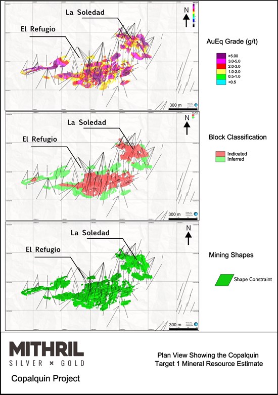
Figure 1: Series of plan view maps of the Mineral Resource Estimate showing: a) AuEq grade (g/t), b) block classification, and c) mining shapes used to constrain the block model
To view an enhanced version of this graphic, please visit:
https://images.newsfilecorp.com/files/11657/303420_f43a72d644e83990_001full.jpg
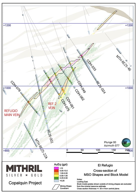
Figure 2: Cross- section view of El Refugio, looking east, showing the mineralised block model and the mining shape constraints used in the Mineral Resource Estimate
To view an enhanced version of this graphic, please visit:
https://images.newsfilecorp.com/files/11657/303420_f43a72d644e83990_002full.jpg
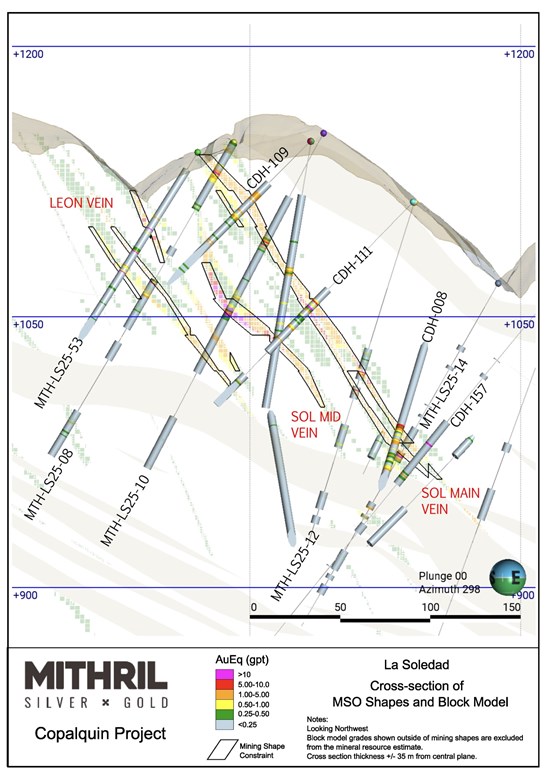
Figure 3: Cross- section view of La Soledad, looking northwest, showing the mineralised block model and the mining shape constraints used in the Mineral Resource Estimate
To view an enhanced version of this graphic, please visit:
https://images.newsfilecorp.com/files/11657/303420_f43a72d644e83990_003full.jpg
Advancing the Copalquin District
Target 1 represents only one of numerous mineralised targets identified within the broader Copalquin District. The Company continues to advance exploration activities across the district, including ongoing drilling at Targets 3 and 5 (Figure 5), where recent results have demonstrated the potential for additional high-grade silver and gold discoveries.
With the updated Target 1 resource now completed, Mithril intends to continue advancing engineering, metallurgical and development studies while pursuing resource growth opportunities across the district.
Two drills are currently active: one following up at Target 5 area and one testing the priority structural targets, with Target 1 westerly step out drilling to follow. Fully funded for further 12,000 metres of drilling for the remainder of 2026 aiming to progress Target 5 to an initial resource, expand Target 1 and progress the district geology model.
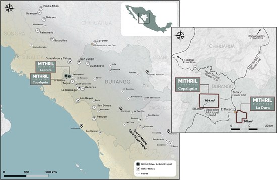
Figure 4: Mithril's Copalquin and La Dura property locations in Durango State, Mexico
To view an enhanced version of this graphic, please visit:
https://images.newsfilecorp.com/files/11657/303420_303420mithrilfigurefour.jpg
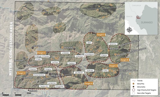
Figure 5: LiDAR identified historic workings across the 70km2 district. Current drilling locations at Target 1, Target 3 and Target 5 with ongoing mapping and sampling plus recently completed aerial magnetic survey (report pending)
To view an enhanced version of this graphic, please visit:
https://images.newsfilecorp.com/files/11657/303420_f43a72d644e83990_006full.jpg
ABOUT THE COPALQUIN SILVER GOLD PROJECT
The Copalquin mining district is located in Durango State, Mexico and covers an entire mining district of 70km2 containing several dozen historic silver and gold mines and workings, ten of which had notable production. The district is within the Sierra Madre Gold Silver Trend which extends north-south along the western side of Mexico and hosts many gold and silver districts.
Multiple mineralisation events, young intrusives thought to be system-driving heat sources, widespread alteration together with extensive surface vein exposures and dozens of historic mine workings, identify the Copalquin mining district as a major epithermal centre for gold and silver mineralisation.
Within 15 months of drilling in the Copalquin District, Mithril delivered a maiden JORC mineral resource estimate (the "2021 MRE", see ASX release 17 November 2021)) at the first of several target areas (Target 1), demonstrating the high-grade gold and silver resource potential for the district. The Upgraded Target 1 Mineral Resource Estimate (effective date June 29, 2026) presented in this release has completely revised and supersedes the 2021 MRE which may no longer be relied upon.
Mithril continues to advance exploration work on the Copalquin project with two active drill rigs, and field programs that are continuously expanding the mapping coverage from approximately 23 square kilometres completed to date of the 70 square kilometres of surfaces area within the concession.
A mining study (conceptual) and metallurgical test work supports the development of the El Refugio-La Soledad resource with conventional underground mining methods indicated as being appropriate and with high silver-gold recovery to produce metal on-site with conventional processing. The average vein width is approximately 4.0 metres.
Mithril is currently exploring in the Copalquin District to expand the resource footprint, to demonstrate its multi-million-ounce gold and silver potential. Mithril has an exclusive option to purchase 100% interest in the Copalquin mining concessions by paying US$10M on or any time before 7 August 2028.
-ENDS-
Released with the authority of the Board.
For further information contact:
The Australian Securities Exchange has not reviewed and does not accept responsibility for the accuracy or adequacy of this release.
Neither TSX Venture Exchange nor its Regulation Services Provider (as that term is defined in policies of the TSX Venture Exchange) accepts responsibility for the adequacy or accuracy of this release.
Competent Persons Statement (JORC), and Qualified Persons (NI 43-101) Statement
The information in this announcement that relates to metallurgical test results, mineral processing and project development and study work has been compiled, reviewed and approved by Mr John Skeet who is Mithril's CEO and Managing Director. Mr Skeet is a Fellow of the Australasian Institute of Mining and Metallurgy. This is a Recognised Professional Organisation (RPO) under the Joint Ore Reserves Committee (JORC) Code and Acceptable Foreign Association under NI 43-101.
Mr Skeet has sufficient experience of relevance to the styles of mineralisation and the types of deposits under consideration, and to the activities undertaken, to qualify as a Competent Person (non-independent) as defined in the 2012 Edition of the Joint Ore Reserves Committee (JORC) Australasian Code for Reporting of Exploration Results, Mineral Resources and Ore Reserves, and as a Qualified Person (non-independent) as defined by NI 43-101. Mr Skeet consents to the inclusion in this report of the matters based on information in the form and context in which it appears. The Australian Securities Exchange has not reviewed and does not accept responsibility for the accuracy or adequacy of this release.
The information in this announcement that relates to sampling techniques, sample data, exploration results and geological interpretation for Mithril's Mexican project, has been compiled, reviewed and approved by Mr James Barr who is Mithril's Vice President - Exploration. Mr Barr is a registered member and Professional Geologist (P.Geo.) of the Engineers and Geoscientists of British Columbia. This is a Recognised Professional Organisation (RPO) under the Joint Ore Reserves Committee (JORC) Code and recognized Canadian Professional Association under NI 43-101.
Mr Barr has sufficient experience of relevance to the styles of mineralisation and the types of deposits under consideration, and to the activities undertaken, to qualify as a Competent Person (non-independent) as defined in the 2012 Edition of the Joint Ore Reserves Committee (JORC) Australasian Code for Reporting of Exploration Results, Mineral Resources and Ore Reserves, and as a Qualified Person (non-independent) as defined by NI 43-101. Mr Barr consents to the inclusion in this report of the matters based on information in the form and context in which it appears.
The information in this announcement that relates to Mineral Resources has been compiled, reviewed and approved by Mr John Sims, a Certified Registered Geologist (CPG) with the American Institute of Professional Geologists (AIPG). This is a Recognised Professional Organisation (RPO) under the Joint Ore Reserves Committee (JORC) Code and Acceptable Foreign Association under NI 43-101.
Mr Sims is acting as the Competent Person (independent), as defined in the 2012 Edition of the Joint Ore Reserves Committee (JORC) Australasian Code for Reporting of Exploration Results, Mineral Resources and Ore Reserves, and as the Qualified Person (independent) as defined by NI 43-101, for the reporting of the Upgraded Copalquin Target 1 Mineral Resource Estimate, with effective date of June 29, 2026. A site visit was carried out by Mr Sims, between 5 May 2025 and 7 May 2025 to observe the drilling, logging, sampling and assay database. Mr Sims has reviewed and approved the contents of this report, and consents to the inclusion in this report of the matters based on information in the form and context in which it appears.
The relevant sections of "JORC Code, 2012 Edition - Table 1" as defined by the Joint Ore Reserves Committee (JORC) Code are incorporated into this Public Report.
A NI 43-101 Technical Report entitled "Technical Report and Upgraded Mineral Resource Estimate for the Copalquin Target 1 Area, Durango, Mexico" will be filed on SEDAR+ within 45 days of this news release.
Sample Analytical Procedures and Quality Assurance/Quality Control:
Drill core logging, sample collection, chain of custody, preparation and assaying of drilling samples from the Copalquin project are done with strict adherence to a Quality Assurance/Quality Control (QA/QC) protocol.
All drill core is logged and sampled by Mithril geologists. Samples lengths are selected to respect important geological contacts, to a minimum length of 0.50m. Drill core is cut longitudinally in half along an oriented drill core line. One half of the core is retained for company record, and the opposing half is sent for laboratory analysis.
All samples are delivered to ALS Minerals for preparation in Chihuahua City, Chihuahua, Mexico for preparation, then internally delivered to ALS Minerals located in North Vancouver, British Columbia, Canada, for analysis and reporting.
Samples are prepared using ALS Minerals Prep-31 crushing (70% passing 2mm), splitting and pulverizing (85% passing 75um, 250g). All samples are submitted for 34 element trace ICP-AES analysis using a four-acid digestion (ME-ICP61), and for 30g gold fire assay with atomic adsorption analysis (Au-AA23). Samples exceeding silver grades of 100 ppm are sent for ore grade analysis (Ag-OG62), and samples with silver grades exceeding 1,500 ppm are sent for fire assay and gravimetric determination (Ag-GRA21). Samples with gold grades exceeding 10 ppm are send for fire assay and gravimetric determination (Au-GRA21). Samples with copper, lead or zinc grades exceeding 10,000 ppm are sent for overlimit analysis using four acid digestion and ICP-AES detection (OG61).
Standards and blanks are inserted at a rate of one per every 25 samples and one per every 40 samples, respectively. Laboratory pulp duplicates are selected by Mithril geologists and requested with each batch of samples.
Analytical certificates are imported directly to the Company's database and reviewed for quality assurance by independent and internal company geologists prior to approved.
JORC Code, 2012 Edition - Table 1
Section 1 Sampling Techniques and Data
| Criteria | JORC Code explanation | Commentary |
| Sampling techniques | - Nature and quality of sampling (e.g. cut channels, random chips, or specific specialised industry standard measurement tools appropriate to the minerals under investigation, such as down hole gamma sondes, or handheld XRF instruments, etc). These examples should not be taken as limiting the broad meaning of sampling.
- Include reference to measures taken to ensure sample representativity and the appropriate calibration of any measurement tools or systems used.
- Aspects of the determination of mineralisation that are Material to the Public Report.
- In cases where 'industry standard' work has been done this would be relatively simple (e.g. 'reverse circulation drilling was used to obtain 1 m samples from which 3 kg was pulverised to produce a 30 g charge for fire assay'). In other cases more explanation may be required, such as where there is coarse gold that has inherent sampling problems. Unusual commodities or mineralisation types (e.g. submarine nodules) may warrant disclosure of detailed information.
| - Drill core samples are cut lengthwise with a diamond saw. Intervals are nominally 1 m but may vary between 0.5 m to 1.5 m based on geologic criteria.
- The same side of the core is always sent to sample (left side of saw).
- Reported intercepts are calculated as either potentially underground mineable (>100m down hole) or as potentially open-pit mineable (near surface).
- Potentially underground mineable intercepts are calculated as length weighted averages of material greater than or equal to 1 g/t AuEQ_70 allowing up to 2m of internal dilution.
- Potentially open-pit mineable intercepts are calculated as length weighted averages of material greater than or equal to 0.25 g/t AuEQ_70 allowing for up to 2m of internal dilution.
- Rock Sawn Channel samples underground and surface are collected with the assistance of a handheld portable saw. The channels are 2.5 to 3cm deep and 6-8 cm wide along continuous lines oriented perpendicular to the mineralised structure. The samples are as representative as possible
- Rock Sawn Channel surface samples were surveyed with a Handheld GPS then permanently mark with an aluminium tag and red colour spray across the strike of the outcrop over 1 metre. Samples are as representative as possible
- Rock Sawn Channel underground samples were located after a compass and tape with the mine working having a surveyed control point at the portal, then permanently marked with an aluminium tag and red colour spray oriented perpendicular to the mineralised structure. Samples are as representative as possible
- Soil sampling has been carried out by locating pre-planned points by handheld GPS and digging to below the first colour-change in the soil (or a maximum of 50 cm). In the arid environment there is a 1 - 10 cm organic horizon and a 10 - 30 cm B horizon above the regolith. Samples are sieved to -80 mesh in the field. Samples are collected on a 20 m x 50 m grid or every 20 m on N-S lines 50 m apart. These samples are considered representative of the medium being sampled and lines are appropriately oriented to the nearly E-W structural trend.
|
| Drilling techniques | - Drill type (e.g. core, reverse circulation, open-hole hammer, rotary air blast, auger, Bangka, sonic, etc) and details (e.g. core diameter, triple or standard tube, depth of diamond tails, face-sampling bit or other type, whether core is oriented and if so, by what method, etc).
| - Drilling is done with MP500 man-portable core rigs capable of drilling HQ size core to depths of 350-400m (depending on ground conditions), reducing to NQ size core for greater depths. Core is recovered in a standard tube.
|
| Drill sample recovery | - Method of recording and assessing core and chip sample recoveries and results assessed.
- Measures taken to maximise sample recovery and ensure representative nature of the samples.
- Whether a relationship exists between sample recovery and grade and whether sample bias may have occurred due to preferential loss/gain of fine/coarse material.
| - Drill recovery is measured based on measured length of core divided by length of drill run.
- Recovery in holes CDH-001 through CDH-025 and holes CDH-032 through CDH-077 was always above 90% in the mineralised zones. Detailed core recovery data are maintained in the project database.
- Holes CDH-026 through CDH-031 had problems with core recovery in highly fractured, clay rich breccia zones.
- There is no adverse relationship between recovery and grade identified to date.
|
| Logging | - Whether core and chip samples have been geologically and geotechnically logged to a level of detail to support appropriate Mineral Resource estimation, mining studies and metallurgical studies.
- Whether logging is qualitative or quantitative in nature. Core (or costean, channel, etc) photography.
- The total length and percentage of the relevant intersections logged.
| - Entire drill holes are logged and sampled by Mithril geologists at the project camp. Logging includes the collection of qualitative data such as host lithology, alteration, mineralogy, and the collection of quantitative data such as oriented structural data, core recovery, and rock quality designation (RQD). Rock properties are measured using magnetic susceptibility, and NIR/SWIR reflectance.
- Data is collected into a centralized database using MX Deposit.
- Drill core is photographed as wet and dry, before sampling and after the core is sampled, and photos are saved in the company database. Rock sawn channel samples are marked, measured and photographed at location
- Soil samples are recorded at location, logged and described
|
| Sub-sampling techniques and sample preparation | - If core, whether cut or sawn and whether quarter, half or all core taken.
- If non-core, whether riffled, tube sampled, rotary split, etc and whether sampled wet or dry.
- For all sample types, the nature, quality and appropriateness of the sample preparation technique.
- Quality control procedures adopted for all sub-sampling stages to maximise representativity of samples.
- Measures taken to ensure that the sampling is representative of the in situ material collected, including for instance results for field duplicate/second-half sampling.
- Whether sample sizes are appropriate to the grain size of the material being sampled.
| - Drill core samples are selected by Mithril's geologists.
- Drill core is cut longitudinally in half along an oriented drill core line. One half of the core is retained for company record, and the opposing half is sent for laboratory analysis. Samples lengths are selected to respect important geological contacts, to a minimum length of 0.50m.
- Samples are prepared using ALS Minerals Prep-31 crushing (70% passing 2mm), splitting and pulverizing (85% passing 75um, 250g).
- Visual review to assure that the cut core is ½ of the core is performed to assure representativity of samples.
- Crushed core duplicates are split/collected by the laboratory and submitted for assay (1 in 30 samples)
- Sample sizes are appropriate to the grain size of the material being sampled.
- Rock sawn channel samples and soil samples are prepared using ALS Minerals Prep-31 crushing, splitting and pulverizing. This is appropriate for the type of deposit being explored.
|
| Quality of assay data and laboratory tests | - The nature, quality and appropriateness of the assaying and laboratory procedures used and whether the technique is considered partial or total.
- For geophysical tools, spectrometers, handheld XRF instruments, etc, the parameters used in determining the analysis including instrument make and model, reading times, calibrations factors applied and their derivation, etc.
- Nature of quality control procedures adopted (e.g. standards, blanks, duplicates, external laboratory checks) and whether acceptable levels of accuracy (i.e. lack of bias) and precision have been established.
| - All samples are submitted for 34 element trace ICP-AES analysis using a four-acid digestion (ME-ICP61), and for 30g gold fire assay with atomic adsorption analysis (Au-AA23).
- Samples exceeding silver grades of 100 ppm are sent for ore grade analysis (Ag-OG62), and samples with silver grades exceeding 1,500 ppm are sent for fire assay and gravimetric determination (Ag-GRA21).
- Samples with gold grades exceeding 10 ppm are send for fire assay and gravimetric determination (Au-GRA21).
- Samples with copper, lead or zinc grades exceeding 10,000 ppm are sent for overlimit analysis using four acid digestion and ICP-AES detection (OG61).
- Standards and blanks are inserted at a rate of one per every 25 samples and one per every 40 samples, respectively. Pulp duplicate sampling is undertaken for 3% of all samples (see above). External laboratory checks will be conducted as sufficient samples are collected. Levels of accuracy (i.e. lack of bias) and precision have not yet been established.
- Certified Reference Materials - Rock Labs and CDN CRMs have been used throughout the project including, low (~2 g/t Au), medium (~9 g/t Au) and high (~18g/t Au and ~40 g/t Au). Results are automatically checked on data import into the BEDROCK database to fall within 2 standard deviations of the expected value.
- Samples with significant amounts of observed visible gold are also assayed by AuSCR21, a screen assay that analyses gold in both the milled pulp and in the residual oversize from pulverization. This has been done for holes CDH-075 and CDH-077.
- Samples are selected in each batch by Mithril geologists for laboratory coarse reject duplicates.
|
| Verification of sampling and assaying | - The verification of significant intersections by either independent or alternative company personnel.
- The use of twinned holes.
- Documentation of primary data, data entry procedures, data verification, data storage (physical and electronic) protocols.
- Discuss any adjustment to assay data.
| - The verification of significant intersections by either independent or alternative company personnel has not been conducted. A re-assay programme of pulp duplicates is currently in progress.
- MTH has drilled one twin hole. Hole CDH-072, reported in the 15/6/2021 announcement, is a twin of holes EC-002 and UC-03. Results are comparable.
- Documentation of primary data, data entry procedures, data verification, data storage (physical and electronic) protocols are maintained in the company's core facility.
- Assay data have not been adjusted other than applying length weighted averages to reported intercepts.
|
| Location of data points | - Accuracy and quality of surveys used to locate drill holes (collar and down-hole surveys), trenches, mine workings and other locations used in Mineral Resource estimation.
- Specification of the grid system used.
- Quality and adequacy of topographic control.
| - Drill collar coordinates are currently located by handheld GPS. Precise survey of hole locations is planned. Downhole surveys of hole deviation are recorded using a Reflex Multishot tool for all holes. A survey measurement is first collected at 15 meters downhole, and then every 50 meters until the end of the hole. Locations for holes have been surveyed with differential GPS to a sub 10 cm precision.
- UTM/UPS WGS 84 zone 13 N
- High quality topographic control from LiDAR imagery and orthophotos covers the entire project area.
|
| Data spacing and distribution | - Data spacing for reporting of Exploration Results.
- Whether the data spacing and distribution is sufficient to establish the degree of geological and grade continuity appropriate for the Mineral Resource and Ore Reserve estimation procedure(s) and classifications applied.
- Whether sample compositing has been applied.
| - Data spacing is appropriate for the reporting of Exploration Results.
- Inferred Mineral Resources are defined within a 70 metre sampling distance, where Indicated Mineral Resources are defined within a 35 metre sample spacing distance.
- Samples are composited to 1 metre for exploratory data analysis and mineral resource estimation.
|
| Orientation of data in relation to geological structure | - Whether the orientation of sampling achieves unbiased sampling of possible structures and the extent to which this is known, considering the deposit type.
- If the relationship between the drilling orientation and the orientation of key mineralised structures is considered to have introduced a sampling bias, this should be assessed and reported if material.
| - Cut lines are marked on the core by the geologists to assure that the orientation of sampling achieves unbiased sampling of possible structures. This is reasonably well observed in the core and is appropriate to the deposit type.
- The relationship between the drilling orientation and the orientation of key mineralised structures is not considered to have introduced a sampling bias.
- Rock sawn channel samples are cut perpendicular to the observed vein orientation wherever possible
|
| Sample security | - The measures taken to ensure sample security.
| - Samples are stored in a secure core storage facility until they are shipped off site by small aircraft and delivered directly to ALS Global sample preparation facility in Chihuahua, Mexico. ALS airfreights the sample pulps to their assaying facility in North Vancouver, BC, Canada.
- All samples are subject to a traceable chain of custody procedure which tracks and enables verification of sampling handling between the project camp and the laboratory
|
| Audits or reviews | - The results of any audits or reviews of sampling techniques and data.
| - A review with spot checks was conducted by AMC in conjunction with the resource estimate published 17 Nov 2021. Results were satisfactory to AMC.
- In conjunction with the Upgraded Mineral Resource Estimate (June 29, 2026), Mr John Sims, , of Sims Resources LLC, conducted a site visit between May 5-7, 2025, at which time he observed drilling, core logging and sample collection activities, including a review of the geological database.
|
Section 2 Reporting of Exploration Results
| Criteria | JORC Code explanation | Commentary |
| Mineral tenement and land tenure status | - Type, reference name/number, location and ownership including agreements or material issues with third parties such as joint ventures, partnerships, overriding royalties, native title interests, historical sites, wilderness or national park and environmental settings.
- The security of the tenure held at the time of reporting along with any known impediments to obtaining a licence to operate in the area.
| |
| | No. | Concession | Concession Title number | Area (Ha) | Location | |
| | 1 | LA SOLEDAD | 52033 | 6 | Tamazula, Durango, Mexico | |
| | 2 | EL COMETA | 164869 | 36 | Tamazula, Durango, Mexico | |
| | 3 | SAN MANUEL | 165451 | 36 | Tamazula, Durango, Mexico | |
| | 4 | COPALQUIN | 178014 | 20 | Tamazula, Durango, Mexico | |
| | 5 | EL SOL | 236130 | 6,000 | Tamazula, Durango and Badiraguato, Sinaloa, México | |
| | 6 | EL CORRAL | 236131 | 907.3243 | Tamazula, Durango and Badiraguato, Sinaloa, México | |
| |
| Exploration done by other parties | - Acknowledgment and appraisal of exploration by other parties.
| - Previous exploration by Bell Coast Capital Corp. and UC Resources was done in the late 1990's and in 2005 - 2007. Work done by these companies is historic and non-JORC compliant. Mithril uses these historic data only as a general guide and will not incorporate work done by these companies in resource modelling.
- Work done by the Mexican government and by IMMSA and will be used for modelling of historic mine workings which are now inaccessible (void model)
|
| Geology | - Deposit type, geological setting and style of mineralisation.
| - Copalquin is a low sulfidation epithermal silver-gold deposit hosted in andesite. This deposit type is common in the Sierra Madre Occidental of Mexico and is characterized by quartz veins and stockworks surrounded by haloes of argillic (illite/smectite) alteration. Veins have formed as both low-angle semi-continuous lenses parallel to the contact between granodiorite and andesite and as tabular veins in high-angle normal faults. Vein and breccia thickness has been observed up to 30 meters wide with average widths on the order of 3 to 5 meters. The overall strike length of the semi-continuous mineralised zone from El Gallo to Refugio, Cometa, Los Pinos, Los Reyes, La Montura to Constancia and Santa Cruz is almost 7 kilometres. The southern area from south west of Apomal to San Manuel and to Las Brujas-El Peru provides additional exploration potential up to 6km.
|
| Drill hole Information | - A summary of all information material to the understanding of the exploration results including a tabulation of the following information for all Material drill holes:
- easting and northing of the drill hole collar
• elevation or RL (Reduced Level - elevation above - sea level in metres) of the drill hole collar
- dip and azimuth of the hole
- down hole length and interception depth
- hole length.
- If the exclusion of this information is justified on the basis that the information is not Material and this exclusion does not detract from the understanding of the report, the Competent Person should clearly explain why this is the case.
| - Exploration Results are not included in the present disclosure.
- Drill hole information has been provided in previous News Release documents.
|
| Data aggregation methods | - In reporting Exploration Results, weighting averaging techniques, maximum and/or minimum grade truncations (e.g. cutting of high grades) and cut-off grades are usually Material and should be stated.
- Where aggregate intercepts incorporate short lengths of high grade results and longer lengths of low grade results, the procedure used for such aggregation should be stated and some typical examples of such aggregations should be shown in detail.
- The assumptions used for any reporting of metal equivalent values should be clearly stated.
| - Potentially underground mineable intercepts are calculated as length weighted averages of material greater than or equal to 1 g/t AuEQ_70 allowing up to 2m of internal dilution.
- Potentially open-pit mineable intercepts are calculated as length weighted averages of material greater than or equal to 0.25 g/t AuEQ_70 allowing for up to 2m of internal dilution.
- No upper cut-off is applied to reporting intercepts.
- Length weighted averaging is used to report intercepts. The example of CDH-002 is shown. The line of zero assays is a standard which was removed from reporting.
|
| | Au
Raw | silver
raw | Length
(m) | Au
*length | silver
*length | | | | | |
| | 7.51 | 678 | 0.5 | 3.755 | 339 | | | | | |
| | 11.85 | 425 | 0.55 | 6.5175 | 233.75 | | | | | |
| | 0 | 0 | 0 | 0 | 0 | | | | | |
| | 0.306 | 16 | 1 | 0.306 | 16 | | | | | |
| | 0.364 | 31.7 | 1 | 0.364 | 31.7 | | | | | |
| | 3.15 | 241 | 0.5 | 1.575 | 120.5 | | | | | |
| | 10.7 | 709 | 0.5 | 5.35 | 354.5 | | | | | |
| | 15.6 | 773 | 0.5 | 7.8 | 386.5 | | | | | |
| | | | | | | From | To | Length | Au
g/t | silver
g/t |
| | | | 4.55 | 25.667 | 1481.9 | 91.95 | 96.5 | 4.55 | 5.64 | 325.7 |
- Constrained and diluted Mineral resources for Copalquin Target 1 are based on underlying metal prices of $3,300/oz Au and $50/oz Ag, unless otherwise noted.
- AuEq g/t = Au g/t + (Ag g/t x (Au price/Ag price) x (Ag recovery/Au recovery)) calculated using the underlying metals prices, along with metallurgical recoveries of 96% Au and 91% Ag from metallurgical test work on Target 1 composite samples. (ASX Announcement 25 February 2022).
|
| Relationship between mineralisation widths and intercept lengths | - These relationships are particularly important in the reporting of Exploration Results.
- If the geometry of the mineralisation with respect to the drill hole angle is known, its nature should be reported.
- If it is not known and only the down hole lengths are reported, there should be a clear statement to this effect (e.g. 'down hole length, true width not known').
| - True widths at Refugio between sections 120 and 1,000 vary according to the hole's dip. Holes drilled at -50 degrees may be considered to have intercept lengths equal to true-widths, Holes drilled at -70 degrees had true widths approximately 92% of the reported intercept lengths and holes drilled at -90 degrees had true widths of 77% of the reported intercept lengths.
- True widths at La Soledad are not fully understood and downhole intercepts to date, are reported.
- At Las Brujas in Target 2, true widths are not yet known since we are still in the early stages of target definition.
- Rock sawn channel samples are cut perpendicular to the observed vein orientation wherever possible
|
| Diagrams | - Appropriate maps and sections (with scales) and tabulations of intercepts should be included for any significant discovery being reported. These should include, but not be limited to a plan view of drill hole collar locations and appropriate sectional views.
| - See figures in announcement
|
| Balanced reporting | - Where comprehensive reporting of all Exploration Results is not practicable, representative reporting of both low and high grades and/or widths should be practiced to avoid misleading reporting of Exploration Results.
| - All exploration results are reported for intercepts greater than or equal to 0.1 g/t gold equivalent (gold plus silver at 70:1 price ratio for gold:silver).
|
| Other substantive exploration data | - Other exploration data, if meaningful and material, should be reported including (but not limited to): geological observations; geophysical survey results; geochemical survey results; bulk samples - size and method of treatment; metallurgical test results; bulk density, groundwater, geotechnical and rock characteristics; potential deleterious or contaminating substances.
| - No additional exploration data are substantive at this time.
- Metallurgical test work on drill core composite made of crushed drill core from the Target 1 drill hole samples has been conducted.
- The samples used for the test work are representative of the material that makes up the majority of the Target 1 Mineral Resource Estimate
- The test work was conducted by SGS laboratory Mexico using standard reagents and test equipment.
- Samples have been selected from drill core produced for Target 1 over the past 2 years. Test work to confirm the previous results will be conducted as well as variability work.
|
| Further work | - The nature and scale of planned further work (e.g. tests for lateral extensions or depth extensions or large-scale step-out drilling).
- Diagrams clearly highlighting the areas of possible extensions, including the main geological interpretations and future drilling areas, provided this information is not commercially sensitive.
| - The Company drilled 148 diamond core holes from July 2020 to July 2022 for 32,712 m. The Company has stated its target to drill up to 45,000m from July 2025 until the second half of 2026 which has been completed.
- The Company has stated it has 12,000 metres of drilling to complete in the second half of 2026.
- Diagrams are included in the announcements and presentations showing the drill target areas within the Copalquin District
|
Section 3 Estimation and Reporting of Mineral Resources
| Criteria | JORC Code explanation | Commentary |
| Database integrity | - Measures taken to ensure that data has not been corrupted by, for example, transcription or keying errors, between its initial collection and its use for Mineral Resource estimation purposes.
- Data validation procedures used.
| - Drillhole data used in the Mineral Resource Estimate were checked for overlapping sample intervals, negative or invalid values, and irregular downhole survey deviation in Leapfrog Geo v.2026.1.1. All errors were assessed and corrected prior to statistical analysis and estimation.
- Standards and blanks are inserted at a rate of one per every 25 samples and one per every 40 samples, respectively. Pulp duplicate sampling is undertaken for 3% of all samples (see above). External laboratory checks will be conducted as sufficient samples are collected. Levels of accuracy (i.e. lack of bias) and precision have not yet been established.
- Certified Reference Materials - Rock Labs and CDN CRMs have been used throughout the project including, low (~2 g/t Au), medium (~9 g/t Au) and high (~18g/t Au and ~40 g/t Au). Results are automatically checked on data import into the BEDROCK database to fall within 2 standard deviations of the expected value.
- Samples with significant amounts of observed visible gold are also assayed by AuSCR21, a screen assay that analyses gold in both the milled pulp and in the residual oversize from pulverization. This has been done for holes CDH-075 and CDH-077.
- Regular comparison between assay data tables and original certificates is completed as assay data are received to ensure consistency between the database and certificates.
- Drillhole collars were checked in 3D to ensure agreement between the LiDAR topography surface and surveyed collar elevation.
- Assays below detection limit were assigned a value equal to half of the detection limit, and unsampled intervals, aside from voids encountered in historical underground workings, were assigned a grade of 0.0001 g/t for both gold and silver prior to estimation.
|
| Site visits | - Comment on any site visits undertaken by the Competent Person and the outcome of those visits.
- If no site visits have been undertaken indicate why this is the case.
| - In conjunction with the Upgraded Mineral Resource Estimate (June 29, 2026), Mr John Sims, of Sims Resources LLC, conducted a site visit between May 5-7, 2025, at which time he observed drilling, core logging and sample collection activities, including a review of the geological database.
|
| Geological interpretation | - Confidence in (or conversely, the uncertainty of ) the geological interpretation of the mineral deposit.
- Nature of the data used and of any assumptions made.
- The effect, if any, of alternative interpretations on Mineral Resource estimation.
- The use of geology in guiding and controlling Mineral Resource estimation.
- The factors affecting continuity both of grade and geology.
| - Lithology solids, including mineralised veins, non-mineralised host rock, and post-mineral dikes, were modelled in Leapfrog Geo using interval selections completed on all core drillholes available. Interval selections consider qualitative logging data, gold and silver assays, and multi-element geochemistry. Surface and underground mapping, trench sampling, and soil samples were also used to validate the interpretation but were not used in estimation.
- High-grade mineralised domains were modelled using a 1 g/t AuEq cutoff and were restricted to modelled vein solids derived from the lithology model.
- A variable orientation search strategy was applied to accurately reflect undulations in modelled veins, with search orientations driven by the nearest vein midpoint surface.
- Post mineral dikes cut and displace mineralised veins in several areas, disrupting vein continuity and gold-silver mineralisation. These post-mineral dikes were assigned a grade of 0.0 g/t for both gold and silver to avoid over-estimation of mineralised material.
|
| Dimensions | - The extent and variability of the Mineral Resource expressed as length (along strike or otherwise), plan width, and depth below surface to the upper and lower limits of the Mineral Resource.
| - The Mineral Resource is hosted within two principal vein corridors - (1) The moderately north-northwest dipping Refugio system, which has an approximate strike x dip extent (from surface) x thickness of 1,200m x 700m x 1-20m and (2) The steeply NNE-dipping Soledad system, which has an approximate strike x dip extent x thickness of 400m x 300m x 1-15m.
|
| Estimation and modelling techniques | - The nature and appropriateness of the estimation technique(s) applied and key assumptions, including treatment of extreme grade values, domaining, interpolation parameters and maximum distance of extrapolation from data points. If a computer assisted estimation method was chosen include a description of computer software and parameters used.
- The availability of check estimates, previous estimates and/or mine production records and whether the Mineral Resource estimate takes appropriate account of such data.
- The assumptions made regarding recovery of by-products.
- Estimation of deleterious elements or other non-grade variables of economic significance (eg sulphur for acid mine drainage characterisation).
- In the case of block model interpolation, the block size in relation to the average sample spacing and the search employed.
- Any assumptions behind modelling of selective mining units.
- Any assumptions about correlation between variables.
- Description of how the geological interpretation was used to control the resource estimates.
- Discussion of basis for using or not using grade cutting or capping.
- The process of validation, the checking process used, the comparison of model data to drill hole data, and use of reconciliation data if available.
| - A single, non-rotated 2.5x2.5x2.5m sub-blocked model was prepared for this Resource Estimate. Up to four divisions of the parent block were accepted to accurately fill veins of variable thickness (minimum sub-block size = 0.625x0.625x0.625m).
- 1.0m composites were generated to reduce variability and ensure consistent support for Resource Estimation, consistent with the median sample length in the drillhole database. Composites do not cross domain boundaries.
- Gold and silver grades were interpolated into the block model using inverse distance cubed (ID3), Nearest Neighbour (NN), and Ordinary Kriging (OK) estimation techniques. The final selected interpolation method is ID3 for both gold and silver. Statistical comparisons show a variance of less than 5% in gold and silver grades between the three methods in most estimation domains.
- Extreme outliers for both gold and silver were evaluated for each estimation domain spatially and using log-histograms, log-probability plots, disintegration analysis, and cumulative metal plots. High-grade restrictions were applied on a domain-by-domain basis, with outlier values capped and restricted to a distance of 1/3 of the first search pass.
- Hard boundaries were applied for all estimation domains, based on contact plots generated for both gold and silver for all contacting domains.
- A three-pass search strategy was applied using the following criteria for each pass - (1) 60x60x10m / 7-12 samples / maximum 3 samples per drillhole; (2) 90x90x15m /4-12 samples / maximum 3 samples per drillhole; (3) 120x120x20m /1-9 samples / maximum 3 samples per drillhole.
- Variable search orientations were applied for all estimation domains, with search orientations controlled by the nearest available vein midpoint surface.
- The final ID3 estimates for gold and silver were validated using statistical comparison (ID3 vs. NN vs. OK), visual validation on cross sections and plan levels, and Swath plots.
- Deleterious elements were not estimated in this Mineral Resource estimate.
|
| Moisture | - Whether the tonnages are estimated on a dry basis or with natural moisture, and the method of determination of the moisture content.
| - All tonnages are estimated on dry basis.
|
| Cut-off parameters | - The basis of the adopted cut-off grade(s) or quality parameters applied.
| - Mineral Resources are reported from within economically constrained Longhole Open Stopes (LHOS) mining shapes generated using Datamine's Mineable Shape Optimizer (MSO). An operating cost of USD$97 tonnes processed was applied. An AuEq grade was basis used to determine block value based on (1) a gold price of US$3,300/oz; (2) a silver price of US$50/oz; (3) gold recovery of 96%; (4) silver recovery of 91%, based on preliminary studies.
|
| Mining factors or assumptions | - Assumptions made regarding possible mining methods, minimum mining dimensions and internal (or, if applicable, external) mining dilution. It is always necessary as part of the process of determining reasonable prospects for eventual economic extraction to consider potential mining methods, but the assumptions made regarding mining methods and parameters when estimating Mineral Resources may not always be rigorous. Where this is the case, this should be reported with an explanation of the basis of the mining assumptions made.
| - Reported gold and silver grades in the Mineral Resource are stope-constrained and include internal dilution. No external dilution was applied.
- Historical workings were flagged to the block model and were assigned a density of 0.0 g/cm3 to exclude mined out material from the stated Mineral Resources.
- LHOS parameters applied in stope optimization include the following - (1) sublevel spacing = 20m; (2) stope slice interval = 5m; (3) minimum mining width = 2m; (4) minimum stope dip = 45 degrees; (5) minimum pillar between adjacent stopes = 0.01m; (6) Indicated and Inferred assurance categories only.
|
| Metallurgical factors or assumptions | - The basis for assumptions or predictions regarding metallurgical amenability. It is always necessary as part of the process of determining reasonable prospects for eventual economic extraction to consider potential metallurgical methods, but the assumptions regarding metallurgical treatment processes and parameters made when reporting Mineral Resources may not always be rigorous. Where this is the case, this should be reported with an explanation of the basis of the metallurgical assumptions made.
| - Metallurgical recoveries of 96% Au and 91% Ag were determined from metallurgical test work on Target 1 composite samples. (ASX Announcement 25 February 2022). The process route for extraction is flotation, intensive cyanide leaching of flotation concentrate and conventional cyanide leaching of the flotation tail. Merrill-Crowe zinc precipitation assumed to recover gold and silver from solutions prior to smelting to produce gold-silver doré bars.
|
| Environmental factors or assumptions | - Assumptions made regarding possible waste and process residue disposal options. It is always necessary as part of the process of determining reasonable prospects for eventual economic extraction to consider the potential environmental impacts of the mining and processing operation. While at this stage the determination of potential environmental impacts, particularly for a greenfields project, may not always be well advanced, the status of early consideration of these potential environmental impacts should be reported. Where these aspects have not been considered this should be reported with an explanation of the environmental assumptions made.
| - The Copalquin project is presently regulated under the Mexican NOM-120 authorisation as a low impact exploration project. As an exploration project, preliminary studies and engagement with SEMARNAT has been initiated, however, an MIA process has not been completed which would include full environmental, permitting, and sociopolitical assessment. The potential future project is not considered to have potential for elevated environment impacts for a modern mining operation.
|
| Bulk density | - Whether assumed or determined. If assumed, the basis for the assumptions. If determined, the method used, whether wet or dry, the frequency of the measurements, the nature, size and representativeness of the samples.
- The bulk density for bulk material must have been measured by methods that adequately account for void spaces (vugs, porosity, etc), moisture and differences between rock and alteration zones within the deposit.
- Discuss assumptions for bulk density estimates used in the evaluation process of the different materials.
| - Bulk density has been measured using wax coated samples using dry mass and displacement methods.
- A total of 1090 samples have been measured across various lithology types. The quartz breccia, which hosts the bulk of mineralisation, has 247 measurements with an average bulk density value of 2.56 (+/- 0.014 margin of error).
- Density values assigned to the block model were derived from the median value reported in each estimation domain group (high-grade, vein, or waste), and range from 2.50 g/cm3 to 2.57 g/cm3. A density of 0.0 g/cm3 was applied to historical workings.
|
| Classification | - The basis for the classification of the Mineral Resources into varying confidence categories.
- Whether appropriate account has been taken of all relevant factors (ie relative confidence in tonnage/grade estimations, reliability of input data, confidence in continuity of geology and metal values, quality, quantity and distribution of the data).
- Whether the result appropriately reflects the Competent Person's view of the deposit.
| - Mineral Resources were classified based on geological continuity and variography analysis of gold and silver in mineralised estimation domains.
- Indicated Mineral Resources were classified based on a drill spacing of 35m or less, and Inferred Resources were classified based on a drill spacing of 35-70m. The Measured category was not used in this estimate because no modern mining has been undertaken at the Project and it is therefore not possible to reconcile the estimate against production or tightly spaced data such as grade control drilling.
- The Competent Person believes that the classification appropriately reflects the continuity of gold and silver mineralisation in this deposit.
|
| Audits or reviews | - The results of any audits or reviews of Mineral Resource estimates.
| - Modelled solids produced by the Company, including quartz veins, high-grade domains, and host lithologies, were reviewed in detail by the Competent Person prior to use in Mineral Resource Estimation.
|
| Discussion of relative accuracy/ confidence | - Where appropriate a statement of the relative accuracy and confidence level in the Mineral Resource estimate using an approach or procedure deemed appropriate by the Competent Person. For example, the application of statistical or geostatistical procedures to quantify the relative accuracy of the resource within stated confidence limits, or, if such an approach is not deemed appropriate, a qualitative discussion of the factors that could affect the relative accuracy and confidence of the estimate.
- The statement should specify whether it relates to global or local estimates, and, if local, state the relevant tonnages, which should be relevant to technical and economic evaluation. Documentation should include assumptions made and the procedures used.
- These statements of relative accuracy and confidence of the estimate should be compared with production data, where available.
| - Production data are not available for this deposit. As such, it was not possible to reconcile the estimate against production records or tightly spaced data such as grade control drilling.
- Statistical validation of the final Inverse Distance cubed (ID3) estimation for gold and silver was completed by comparing to Nearest Neighbour (NN) and Ordinary Kriging (OK) estimates for each individual domain used in the estimation. A variance of less than 5% is observed for most domains when comparing the three estimation methods.
- Accuracy of the estimate may be affected by a variety of factors, including uncertainty in the geological interpretation and uncertainty in the position and size of historical mine workings in cases where workings are unknown or inaccessible.
- Future geotechnical or geometallurgical studies, commodity price changes, and capital and operating cost estimates could also impact revenue and cost inputs used in the Resource Estimate.
-
|
1 See ASX announcement dated 25 February 2022, "Further Excellent Metallurgy Results - Copalquin District, Mexico"
2 See ASX announcement dated 25 February 2022, "Further Excellent Metallurgy Results - Copalquin District, Mexico"

To view the source version of this press release, please visit https://www.newsfilecorp.com/release/303420

© 2026 Canjex Publishing Ltd. All rights reserved.