TORONTO, Sept. 09, 2026 (GLOBE NEWSWIRE) -- Nobel Resources Corp. (TSX – V: NBLC; OTCPK: NBTRF) (the “Company” or “Nobel”) announces the plan for its next phase of drilling at its Cuprita copper project (“Cuprita” or the “Project”) and the initial exploration at the Janett project (“Janett” and together with Cuprita, the “Projects”) (See Figure 1 below).
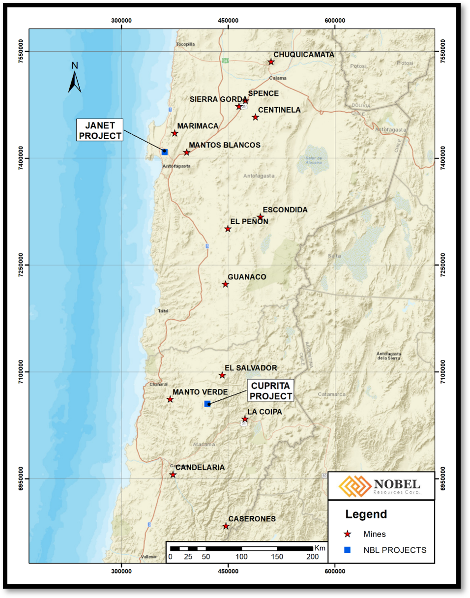
Figure 1. Location of the Cuprita and Janett Projects. Please note that the other deposits located on the map are for reference only and do not correlate with the Cuprita and Janett projects.
At Cuprita, the final geophysical results from the Pole-Dipole induced polarisation (IP) survey completed by Quantec (Please see the Company’s news release dated July 16, 2026) were received. Quantec completed a 3D inversion model that highlighted a large and continuous chargeability anomaly that corresponds with the mapped lithocap and extends the target area to the south and east of the area where exploration has been concentrated to date. The newly identified anomaly, south of the previously known lithocap occurs under shallow overburden cover and represents an extensive untested area for potential mineralization. The total area of corresponding lithocap and IP chargeability anomaly now extends over approximately 1.0 km by 3.0 km along a NNW elongated axis (Figure 2). Exploration by Nobel to date has identified a multiphase intrusive complex, extensive lithocap development, widespread chalcopyrite (+/- bornite) and molybdenite in porphyry-type alteration and mineralization.
Based on the integration of the 3D Inversion model with the geochemical, geological and hyperspectral mineral mapping data, Nobel proposes a Reverse Circulation (“RC”) drilling program at the Cuprita Project, designed to test the highest-priority targets (Figure 3).
3D Geophysical Target:
The Quantec DCIP (Direct Current Induced Polarisation) survey consisted of nine east-west Pole-Dipole profiles spaced 500 meters apart, approximately 2.6 km long each, for a total coverage of approximately 23.4 line-km. 3D inversion modeling of this survey data represents a major improvement in the targeting capability at Cuprita.
At approximately 250 meters below surface, the chargeability model outlines a broad anomalous body measuring approximately 3 km × 1 km, containing two principal higher-chargeability centers exceeding approximately 7 mV/V.
Importantly the dimensions, geometry and orientation of this subsurface response broadly correspond with the lithocap and hydrothermal alteration footprint independently defined through geological mapping and hyperspectral mineral analysis.
The relationship between the two chargeability centers also raises the possibility that they may represent different expressions of a single, larger sulphide-bearing hydrothermal system at depth.
The spatial convergence between chargeability, intrusive geology, hydrothermal alteration, Cu-Mo geochemistry and porphyry-related mineralization provides a compelling framework for systematic drill testing. Particularly given the location of the project within a highly productive copper porphyry producing region in Chile.
According to Vernon Arseneau, CEO and Director of Nobel, “The next phase of drilling at Cuprita aims to intersect the core of the system where economic mineralization is most likely to be located. We are confident that with this program, we will succeed in locating the highest grade mineralization from this exciting recently identified porphyry system.”
Drilling is designed to test target volumes considered capable of hosting a large-scale porphyry copper deposit in excess of 500 million tons of copper mineralization within 500m of the surface. The program is intended to provide a decisive test of Cuprita’s potential to host a major porphyry copper-molybdenum deposit.
An initial program of approximately 3,200 meters of RC drilling is planned (Figures 2 and 3).
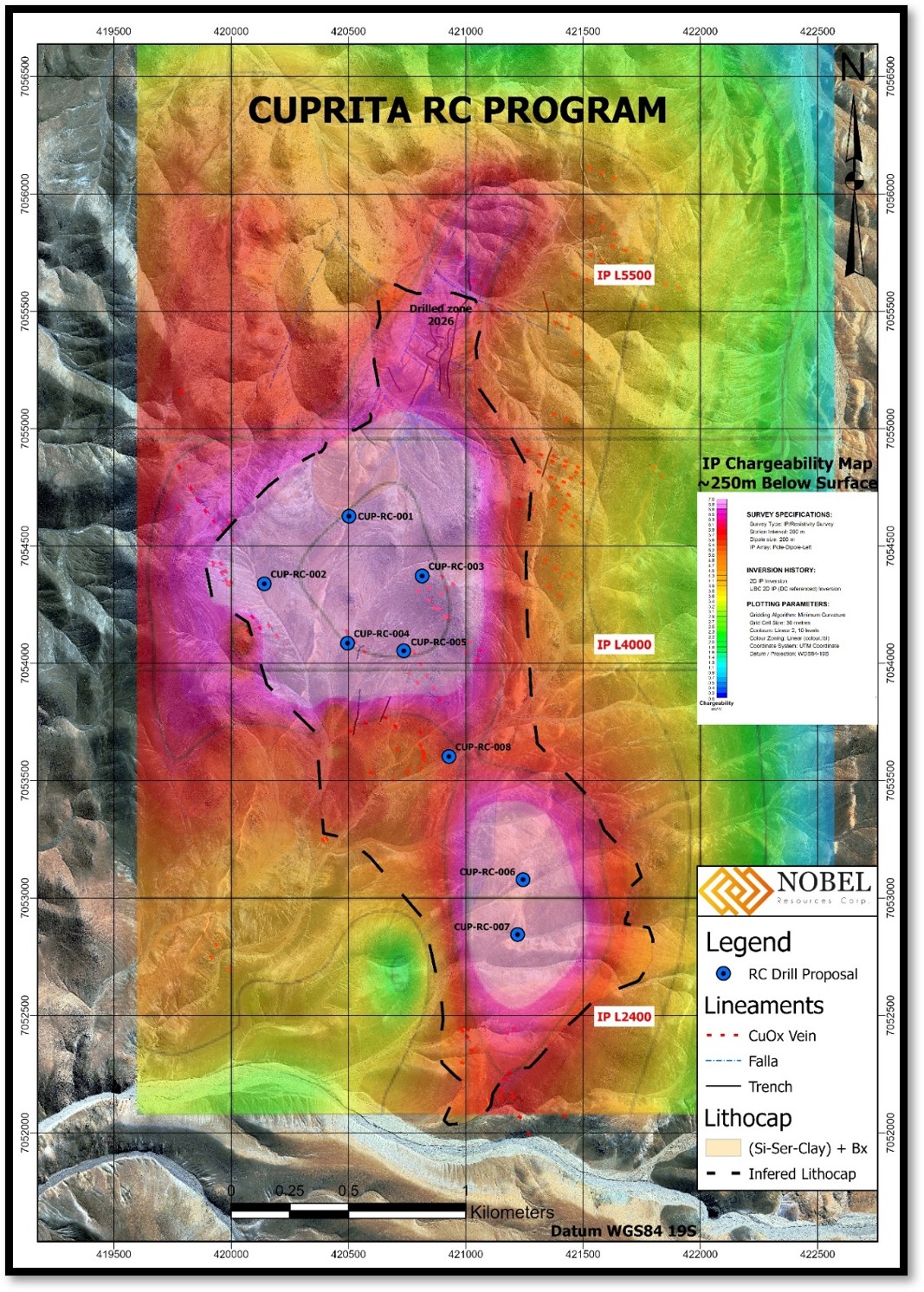
Figure 2: IP Chargeability 3-D Plan Map at 250m below surface (1600MASL) with proposed RC drill holes.
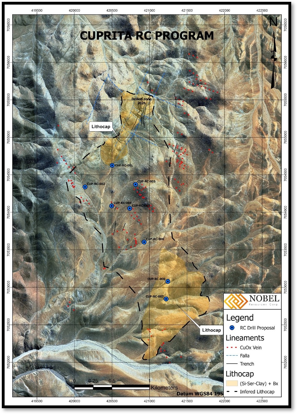
Figure 3: Location of proposed drilling.
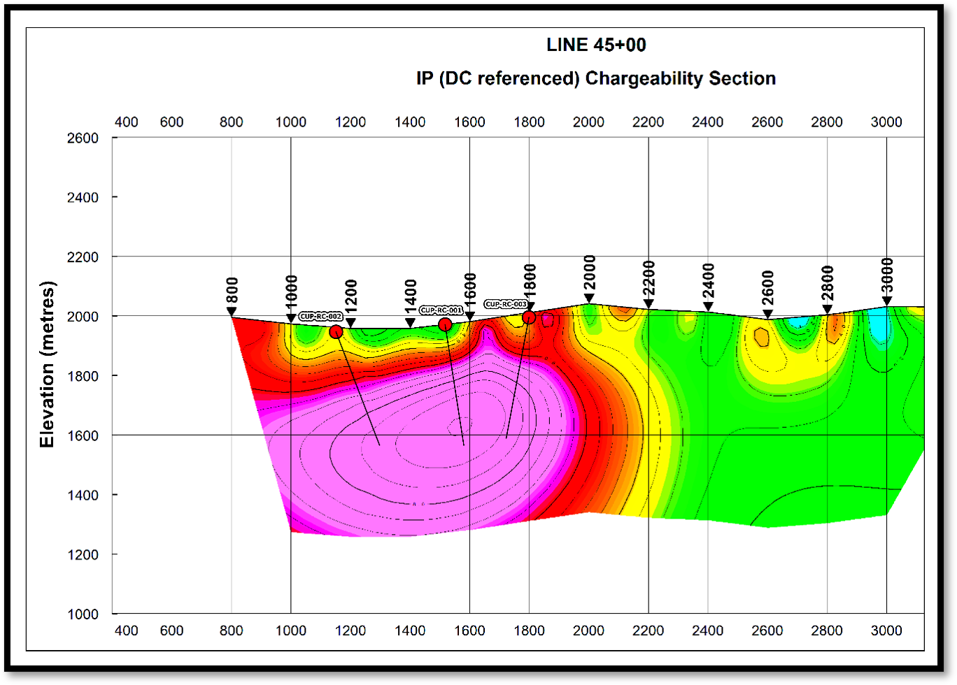
Figure 4
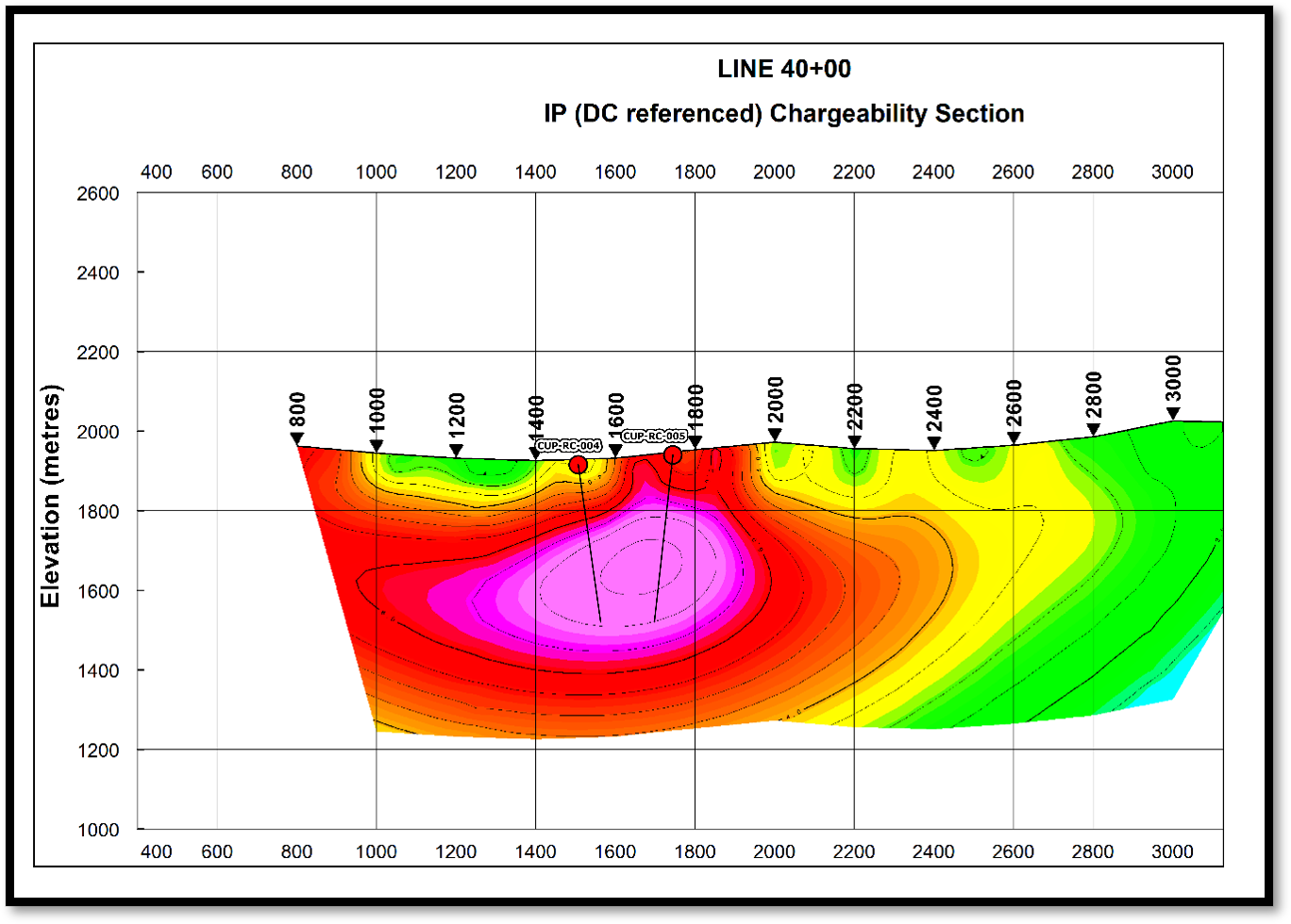
Figure 5
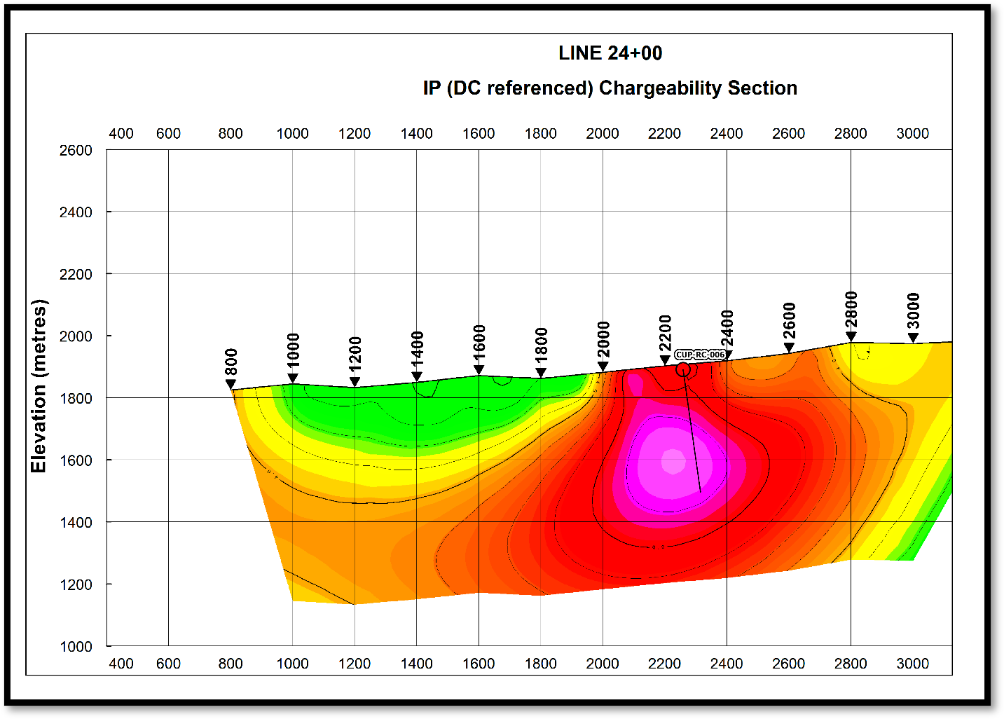
Figure 6
Figures 4, 5 and 6: Selected representative IP chargeability sections showing the proposed RC drill-hole locations. The sections illustrate the spatial relationship between the planned drilling and the principal chargeability features within the 3D anomaly, providing a clear representation of the target volumes to be tested during the proposed drilling campaign.
Janett Project
The Janett project is located close to Antofagasta and is host to manto style mineralization that produced copper for a number of years in recent history.
The past producing Janett deposit is part of the coastal “stratabound copper deposit” metallogenic belt that can be followed for 400 km from Taltal to Tocopilla in northern Chile. Janett is located 16 km NNE of Antofagasta. A key feature of this type of deposit is the genetic link to magmatic hydrothermal fluids and proximity to intrusives.
The Janett Project contains several past producing small-scale mines including the Janett and Michos mines. The Janett mine was a combination of a shallow open pit and underground workings.
Historical sampling done by the vendors of 10 channel samples along 5m widths were taken on the South wall of the Janett open pit. Average grade over the 55 m was 0.79% copper. Copper oxide Mineralization remains open to the North, East, South and West.
The Company is acquiring the exploration permits required to commence the initial field follow up to determine the extent of the mineralized zones there. Initial work will comprise geological mapping, geochemistry and geophysical surveys.
Quality Assurance and Quality Control (QA/QC)
Sampling is conducted in a manner designed to allow appropriate averaging and statistical analysis of the data for exploration evaluation and potential future resource estimation. Industry-standard QA/QC procedures are implemented throughout the sampling and analytical process, including the systematic insertion of certified reference materials, blanks and duplicate samples to monitor laboratory performance and analytical accuracy. Drill core samples are typically collected over intervals ranging from 1 to 2 metres, depending on geological boundaries. Shorter sample intervals are avoided whenever possible to maintain consistency and representativity of the sampled material. Prior to sampling, the drill core is geologically logged and photographed to create a high-resolution photographic record. Core samples are then split along the core axis using an electric rock saw by trained company technicians. One half of the core is sent for analysis while the remaining half is retained on site for reference and verification.
As part of the QA/QC program, one certified reference standard is inserted every 20 core samples. Additionally, one coarse blank, one fine blank and one internal duplicate sample are inserted approximately every 50 core samples to monitor contamination, analytical precision and laboratory performance.
To ensure sample security and compliance with NI 43-101 chain-of-custody standards, samples are placed in sealed rice bags with numbered security tags at the project site. Samples are then transported by company personnel via truck to the analytical laboratory. Custody and transfer of the samples always remain under the responsibility of company personnel. Sample preparation and analytical work are carried out by Andes Analytical Assays, an independent certified laboratory.
Qualified Person
The scientific and technical information in this news release has been reviewed and approved by Mr. David Gower, P.Geo and a qualified person, as defined by National Instrument 43-101 of the Canadian Securities Administrators. Mr. Gower is a consultant of Nobel and is not considered independent of the Company.
About Nobel
Nobel Resources is a Canadian resource company focused on identifying and developing prospective mineral projects. The Company has a team with a strong background of exploration success.
For further information, please contact:
Vern Arseneau
Chief Executive Officer
+1 647-276-0533
Vincent Chen
Investor Relations
vchen@nobel-resources.com
www.nobel-resources.com
Cautionary Note Regarding Forward-looking Information
This press release contains “forward-looking information” within the meaning of applicable Canadian securities legislation. Forward-looking information includes, without limitation, the mineralization and prospectivity of the Cuprita project and the Janett project, the Company’s ability to explore and develop the Projects, the timing and results of the drill program and other surveys, the Company’s ability to obtain adequate financing and the Company’s future plans. Generally, forward-looking information can be identified by the use of forward-looking terminology such as “plans”, “expects” or “does not expect”, “is expected”, “budget”, “scheduled”, “estimates”, “forecasts”, “intends”, “anticipates” or “does not anticipate”, or “believes”, or variations of such words and phrases or state that certain actions, events or results “may”, “could”, “would”, “might” or “will be taken”, “occur” or “be achieved”. Forward- looking information is subject to known and unknown risks, uncertainties and other factors that may cause the actual results, level of activity, performance or achievements of Nobel, as the case may be, to be materially different from those expressed or implied by such forward-looking information, including but not limited to: general business, economic, competitive, geopolitical and social uncertainties; the actual results of current exploration activities; risks associated with operation in foreign jurisdictions; ability to successfully integrate the purchased properties; foreign operations risks; and other risks inherent in the mining industry. Although Nobel has attempted to identify important factors that could cause actual results to differ materially from those contained in forward-looking information, there may be other factors that cause results not to be as anticipated, estimated or intended. There can be no assurance that such information will prove to be accurate, as actual results and future events could differ materially from those anticipated in such statements. Accordingly, readers should not place undue reliance on forward-looking information. Nobel does not undertake to update any forward-looking information, except in accordance with applicable securities laws.
NEITHER TSX VENTURE EXCHANGE NOR ITS REGULATION SERVICES PROVIDER (AS THAT TERM IS DEFINED IN THE POLICIES OF THE TSX VENTURE EXCHANGE) ACCEPTS RESPONSIBILITY FOR THE ADEQUACY OR ACCURACY OF THIS RELEASE.
Photos accompanying this announcement are available at:
https://www.globenewswire.com/NewsRoom/AttachmentNg/9e1eea04-e164-4655-9804-3ed96cdf9c42
https://www.globenewswire.com/NewsRoom/AttachmentNg/66dcbe89-572d-4538-9328-f550b397fce0
https://www.globenewswire.com/NewsRoom/AttachmentNg/fe194752-ee22-435a-9b6a-f2c72a973444
https://www.globenewswire.com/NewsRoom/AttachmentNg/d239e698-c061-45c5-a13a-448972a4963e
https://www.globenewswire.com/NewsRoom/AttachmentNg/e4c71762-6ab9-4589-a181-a99ec7298e14
https://www.globenewswire.com/NewsRoom/AttachmentNg/3e861117-599b-4fb8-8249-9e054592ecfe



Figure 1
Location of the Cuprita and Janett Projects. Please note that the other deposits located on the map are for reference only and do not correlate with the Cuprita and Janett projects.
Figure 2
IP Chargeability 3-D Plan Map at 250m below surface (1600MASL) with proposed RC drill holes.
Figure 3
Location of proposed drilling.
Figure 4
Selected representative IP chargeability sections showing the proposed RC drill-hole locations. The sections illustrate the spatial relationship between the planned drilling and the principal chargeability features within the 3D anomaly, providing a clear representation of the target volumes to be tested during the proposed drilling campaign.
Figure 5
Selected representative IP chargeability sections showing the proposed RC drill-hole locations. The sections illustrate the spatial relationship between the planned drilling and the principal chargeability features within the 3D anomaly, providing a clear representation of the target volumes to be tested during the proposed drilling campaign.
Figure 6
Selected representative IP chargeability sections showing the proposed RC drill-hole locations. The sections illustrate the spatial relationship between the planned drilling and the principal chargeability features within the 3D anomaly, providing a clear representation of the target volumes to be tested during the proposed drilling campaign.
© 2026 Canjex Publishing Ltd. All rights reserved.