(via TheNewswire)
Vancouver, BC – July 15, 2026 – TheNewswire - Stellar AfricaGold Inc. (“Stellar” or the “Company”) (TSXV: SPX, TGAT: 6YP and FSX: 6YP) is pleased to announce that a 10,000-meter auger drill program is now underway at the Stellar-MetalsGrove Joint Venture Zuénoula Gold Project, Cote d’Ivoire.
Highlights
New 200m × 50m infill soil sampling results from the Fifty-Five Prospect have extended Drill Target T1 to a strike length of approximately 3.3km . The program also returned a new peak soil assay of 1,324ppb Au (1.324g/t Au) , further supporting the high prospectivity of the target area.
A 200m X 50m infill soil sampling program is underway across Drill Target T6 within the South East Prospect , and a similar program is scheduled over Drill Target T2 in the northeastern extension of the Fifty-Five Prospect . These programs are designed to further refine drill target geometry and prioritise targets for follow-up auger drilling.
Assay results have been received for 3,372 soil samples , with a further 343 samples pending assay. In parallel, 601 additional soil samples are being collected, while auger drilling comprising 503 holes at the Fifty-Five Prospect and 472 holes at the Central Prospect is underway.
About the Stellar-MetalsGrove Joint Venture Zuénoula Gold Project, Cote d’Ivoire.
The Stellar-MetalsGrove Zuénoula Gold Project is a joint venture exploration project between Stellar’s Ivorian subsidiary Aucrest SARL (“Aucrest”) and MetalsGrove Mining Ltd.’s subsidiary MetalsGrove CDI Pty Ltd (MetalsGrove) to advance Stellar’s 395.78 square kilometer early-stage exploration permit called Zuénoula in Côte d’Ivoire (see Figure 2 below). Pursuant to the joint venture agreement MetalsGrove, the project operator, may earn up to a 50% interest in the Zuénoula Gold Project by incurring US$3,000,000 in exploration expenditures and up to an 80% interest in the Zuénoula Gold Project by incurring a total of US$6,000,000 in exploration expenditures. ( For further details of the Stellar-MetalsGrove Joint Venture Agreement see Stellar news release December 9, 2025.)
Stellar Management Commentary
Stellar President and CEO J. François Lalonde commented:
"The commencement of auger drilling represents an important milestone in the Joint Venture’s systematic exploration strategy at the Zuénoula Permit. Over the past 6 months, the project has been progressively advanced from regional reconnaissance through multiple phases of soil geochemistry, enabling the exploration team to refine its focus to three principal prospects and six drill targets. This disciplined approach is now delivering tangible drill-ready targets for the first phase of subsurface testing.
The continued expansion of drill target T1 to approximately 3.3 kilometres and the identification of a new peak soil assay of 1.324 g/t gold from the prospect area reinforces our confidence in the scale and prospectivity of the Zuénoula gold system. These results demonstrate that ongoing infill soil sampling continues to enhance our understanding of the Zuénoula project and improve the quality of drill targeting.
Importantly, the auger drilling program is expected to provide the first direct assessment of the bedrock potential beneath these extensive surface gold anomalies. Together with additional infill soil sampling planned over the remaining target areas, the results will be used to prioritise follow-up Aircore, Reverse Circulation and diamond drilling later this year. We believe the Zuénoula Permit continues to demonstrate significant potential for gold discoveries as our exploration progresses."
10,000-METER AUGER DRILLING PROGRAM COMMENCED; SIX DRILL TARGET AREAS TO BE TESTED
Stellar is pleased to announce that a 10,000m auger drilling program has commenced at its Zuénoula Permit in Côte d’Ivoire to test six drill target areas defined from multiple gold anomalies identified through the Company’s systematic soil geochemistry programs.
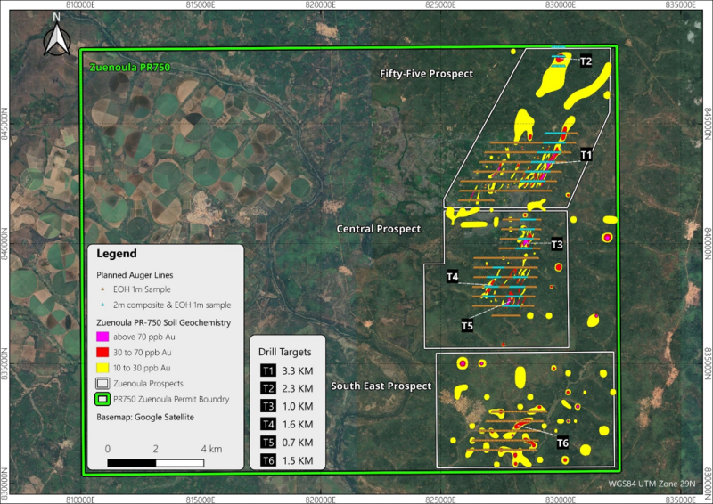
Ongoing interpretation of recently completed infill soil sample results (Table 1) has further enhanced the Joint Venture’s understanding of the Zuénoula Permit, enabling exploration activities to be focused on three principal prospects: Fifty-Five, Central and South East (Figure 1),where increased confidence in the continuity and distribution of gold anomalism has led to the definition of six drill targets , which will be systematically evaluated through the current auger drilling program before advancing to Aircore (AC), Reverse Circulation (RC) and Diamond Drilling (DD) from late 2026.
Click Image To View Full Size
Figure 1. Planned Auger Drill Lines Over Gold Anomalous Contours Across Six Drill Targets within the Fifty-Five, Central and South East Prospects at the Zuénoula Permit.
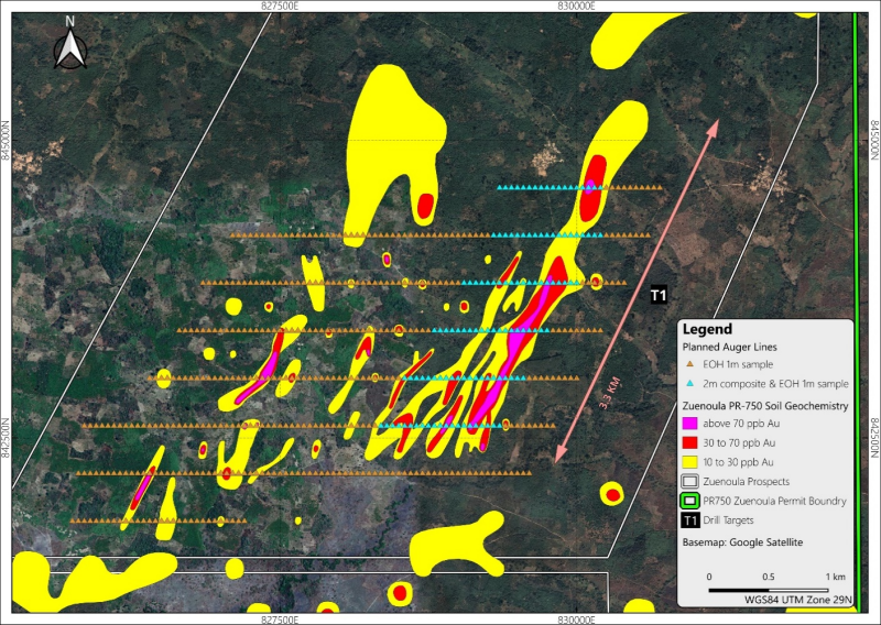
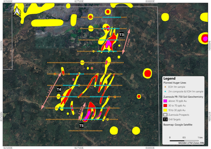
Recent 200m × 50m infill soil sampling has further refined the Company's priority drill targets within the Fifty-Five and Central Prospects . At the Fifty-Five Prospect (Figure 2), the T1 drill target has been extended to approximately 3.3km from 2.0km strike length previously, while a new peak soil assay of 1,324ppb Au (1.324g/t Au) has been identified. At the Central Prospect (Figure 3), the refined T3, T4 and T5 drill targets will be tested with the planned auger drilling program.
Click Image To View Full Size
Figure 2. Planned Auger Drill Lines Over Gold Contours Across the 3.3km-long T1 Drill Target
within the Fifty-Five Prospect, Zuénoula Permit
Click Image To View Full Size
Figure 3. Planned Auger Drill Lines Over Gold Contours Across the T3-T5 Drill Targets
within the Central Prospect, Zuénoula Permit
Auger Drilling Program
The planned 10,000-meter auger drilling program has commenced following successful meetings with local authorities, including mines department and various community representatives. The initial program will focus on the highest-priority gold anomalous clusters identified from systematic soil geochemistry around the areas of Drill Targets T1 and T3–T5 within the Fifty-Five and Central Prospects, providing the first direct assessment of potential bedrock-related gold mineralisation beneath the surface geochemical anomalies. Results from this program will be used to refine subsequent drill targeting and guide follow-up exploration.
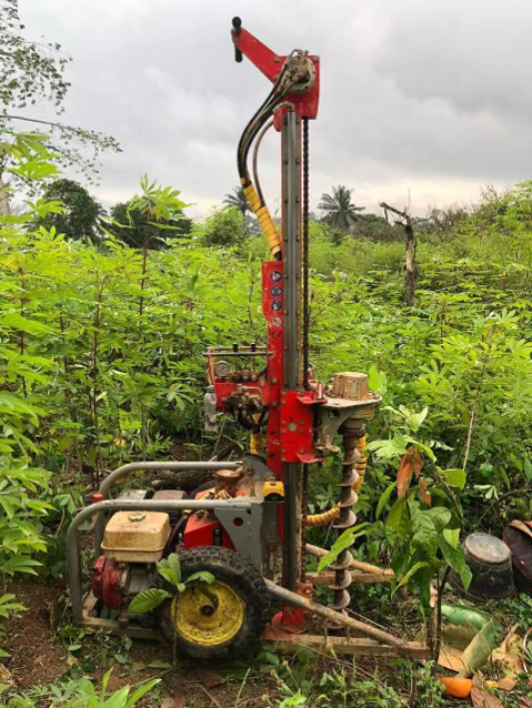
The auger drilling program has been designed to an average depth of approximately five metres, targeting the upper saprolite horizon where residual gold geochemical signatures are expected to be best preserved. Drilling through the complete weathering profile will provide important geological and regolith information while enabling evaluation of the relationship between surface soil anomalies and the potential underlying saprolite-hosted mineralisation.
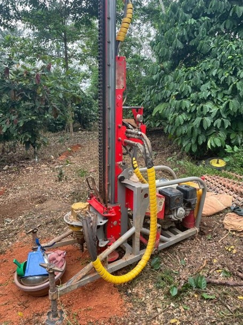
A selective sampling strategy has been adopted to maximise geological information while maintaining analytical efficiency. Holes located within priority drill target areas will be sampled as continuous 2m composite intervals throughout the entire hole, together with an additional bottom-of-hole (BOH) sample collected from the upper saprolite horizon. Outside the priority target areas, only the BOH sample will be collected. This approach is expected to provide a better understanding of vertical gold distribution within the weathering profile and improve interpretation of the relationship between surface geochemical anomalies and potential bedrock mineralisation.
Continuing soil sampling
Infill soil sampling at 200m × 50m spacing will continue to support target refinement across the Zuénoula Permit. The current program is focused on Drill Target T6 within the South East Prospect, with a further campaign planned over Drill Target T2 in the northeastern extension of the Fifty-Five Prospect. These programs are designed to improve anomaly definition, refine drill target geometry and assist in prioritising targets for future auger and follow-up AC, RC, or DD drilling.
Next Phases of Work
The Joint Venture plans the following next phases of exploration programs to advance the identification of new potential drill targets and refine existing potential drill targets for drill testing:
Fifty-Five Prospect NE: 200m x 200m 343 samples (pending assay results)
South East Prospect: 200m x 500m, 601 samples (sampling underway)
Table 1. Zuénoula PR750 – Soil Samples Assays Above 70 ppb Au
WGS-84 UTM Zone 29N
Sample ID | Zone | East | North | Au ppb (FA) |
KN2826 | WGS84_29N | 827401 | 842999 | 1,324 |
KN1566 | WGS84_29N | 829900 | 847800 | 1,242 |
KN2654 | WGS84_29N | 828550 | 843001 | 968 |
KN0551 | WGS84_29N | 827300 | 842600 | 583 |
KN2504 | WGS84_29N | 829350 | 843001 | 575 |
KN2724 | WGS84_29N | 828250 | 843200 | 415 |
KN2110 | WGS84_29N | 828551 | 837800 | 344 |
KN1364 | WGS84_29N | 827303 | 838804 | 297 |
KN2011 | WGS84_29N | 827950 | 839201 | 278 |
KN2399 | WGS84_29N | 827750 | 837400 | 275 |
KN1487 | WGS84_29N | 828499 | 840199 | 272 |
KN0741 | WGS84_29N | 829299 | 842800 | 263 |
KN2341 | WGS84_29N | 828550 | 838200 | 263 |
KN2824 | WGS84_29N | 827350 | 843000 | 250 |
KN2164 | WGS84_29N | 828600 | 840000 | 246 |
KN2249 | WGS84_29N | 828399 | 838402 | 245 |
KN2093 | WGS84_29N | 827999 | 837599 | 238 |
KN2090 | WGS84_29N | 827799 | 837599 | 213 |
KN2547 | WGS84_29N | 830150 | 843800 | 205 |
KN0955 | WGS84_29N | 827102 | 832199 | 200 |
KN2226 | WGS84_29N | 828251 | 838600 | 190 |
KN2754 | WGS84_29N | 829449 | 843399 | 190 |
KN0670 | WGS84_29N | 826299 | 842001 | 189 |
KN2302 | WGS84_29N | 828750 | 839001 | 178 |
KN1930 | WGS84_29N | 828901 | 842600 | 173 |
KN2197 | WGS84_29N | 828549 | 840600 | 155 |
KN0276 | WGS84_29N | 827600 | 835800 | 148 |
KN2736 | WGS84_29N | 829200 | 842401 | 146 |
KN0089 | WGS84_30N | 169324 | 836993 | 144 |
KN1338 | WGS84_29N | 827700 | 837399 | 143 |
KN3242 | WGS84_29N | 828500 | 831800 | 143 |
KN2753 | WGS84_29N | 829549 | 843400 | 139 |
KN3150 | WGS84_29N | 830700 | 833200 | 136 |
KN1901 | WGS84_29N | 827200 | 842600 | 134 |
KN0793 | WGS84_29N | 828697 | 843798 | 131 |
KN1095 | WGS84_29N | 825906 | 834994 | 130 |
KN0768 | WGS84_29N | 827901 | 843399 | 128 |
KN2703 | WGS84_29N | 829450 | 843200 | 126 |
KN2515 | WGS84_29N | 828398 | 844001 | 121 |
KN1257 | WGS84_30N | 169802 | 840202 | 118 |
KN2558 | WGS84_29N | 829251 | 842800 | 111 |
KN2867 | WGS84_29N | 826850 | 842398 | 110 |
KN2167 | WGS84_29N | 828453 | 839997 | 109 |
KN2234 | WGS84_29N | 827951 | 838802 | 109 |
KN2058 | WGS84_29N | 827250 | 837801 | 107 |
KN0802 | WGS84_29N | 829700 | 843601 | 105 |
KN2907 | WGS84_29N | 826400 | 842200 | 103 |
KN2510 | WGS84_29N | 829005 | 843008 | 98 |
KN2091 | WGS84_29N | 827850 | 837599 | 96 |
KN1470 | WGS84_29N | 828499 | 839993 | 95 |
KN2098 | WGS84_29N | 828250 | 837601 | 94 |
KN3326 | WGS84_29N | 828100 | 831201 | 94 |
KN1762 | WGS84_29N | 830100 | 844600 | 92 |
KN2266 | WGS84_29N | 826651 | 839000 | 92 |
KN2628 | WGS84_29N | 829749 | 843799 | 91 |
KN1699 | WGS84_29N | 829100 | 842600 | 90 |
KN2672 | WGS84_29N | 827151 | 842799 | 85 |
KN1423 | WGS84_29N | 827496 | 838597 | 84 |
KN2809 | WGS84_29N | 827450 | 843200 | 84 |
KN0783 | WGS84_29N | 829504 | 843399 | 80 |
KN2030 | WGS84_29N | 828452 | 839399 | 80 |
KN2404 | WGS84_29N | 828050 | 837400 | 80 |
KN0708 | WGS84_29N | 829100 | 842599 | 79 |
KN1112 | WGS84_29N | 826699 | 834999 | 79 |
KN3182 | WGS84_29N | 830301 | 832601 | 78 |
KN0749 | WGS84_29N | 828301 | 843001 | 77 |
KN0045 | WGS84_29N | 828001 | 831999 | 72 |
Qualified Person
The technical information contained in this release has been reviewed and approved by Mr. Lijun Yang, a current member of the Australian Institute of Geoscientists (MAIG) and Managing Director of MetalsGrove Mining Limited. Mr. Yang is independent of Stellar AfricaGold Inc.
Mr. Yang is a Qualified Person under National Instrument 43-101.
About Stellar Africagold Inc.
Stellar AfricaGold Inc. is a Canadian precious metal exploration company focused on precious metals
in North and West Africa, with active programs in Morocco and Côte d’Ivoire. Stellar’s principal exploration projects are its advancing gold discovery at the Tichka Est Gold Project in Morocco, and its
early-stage exploration Zuénoula Gold Project in Côte d’Ivoire which is operated in Joint Venture with MetalsGrove Mining Ltd subsidiary, MetalsGrove CDI Pty Ltd.
The Company is listed on the TSX Venture Exchange symbol TSX.V: SPX, the Tradegate Exchange TGAT: 6YP and the Frankfurt Stock Exchange FSX: 6YP.
The Company maintains its head office in Vancouver, BC and has a country office in Marrakech, Morocco.
QA/QC
JORC Code, 2012 Edition – Table 1
Section 1 - Sampling Techniques and Data
Criteria | JORCCodeExplanation | Commentary |
Sampling Techniques | Nature and quality of sampling (e.g. cut channels, random chips, or specific specialied industry standard measurement tools appropriate to the minerals under investigation, such as downhole gamma sondes, or handheld XRF instruments, etc.) These examples should not be taken as limiting the broad meaning of sampling.
Include reference to measures taken to ensure sample representivity and the appropriate calibration of any measurement tools or systems used.
Aspects of the determination ofmineralisation that are Material to the Public Report.
In cases where ‘industry standard’ work has been done, this would be relatively simple (e.g. ‘reverse circulation drilling was used to obtain 1 m samples from which 3 kg was pulverised to produce a 30 g charge for fire assay’). In other cases, more explanation may be required, such as where there is coarse gold that has inherent sampling problems. Unusual commodities or mineralisation types (e.g. submarine nodules) may warrant disclosure of detailed information.
| All soil samples collected on Zuénoula PR-750 have been analysed for gold by fire assay at Bureau Veritas laboratory in Abidjan, Côte d’Ivoire.
Soil Sampling Stages Stage 1: Initial, permit-wide, broad-spaced soil sampling on 1000m x 1000m grid
Stage 2: Gold anomalous clusters and trends defined by multiple anomalous soil samples (+20ppb Au) are then infilled with soil samples collected on 400m x 400m grid
Stage 3: Coherent gold soil anomalies are then infilled with soil samples collected on 200m x 200m grid
Stage 4: Higher density 200m x 50m soil sampling to sharpen definition of gold soil anomalies
Stage 5: Augering of coherent gold soil anomalies
Stage 6: Drill testing of gold soil and auger anomalies.
SOIL SAMPLING PROCEDURES MGA has contracted the experienced consulting group SEMS Exploration Services (SEMS) to conduct all soil sampling
Up to four sampling crews may be active at any one time
The MGA Exploration Manager was onsite at the start of the field program to instruct the sampling crew on the Standard Sampling Procedure required by MGA
MGA provided SEMS Exploration Services with an Excel table listing the designated sample point locations using WGS-84 UTM zone 29N coordinates
Each soil sample is collected from within 20 metres of the designated sample point, with the actual sample point then recorded
At each sample point: 1) the organic rich soil is brushed away, 2) a 40cm deep hole dug and the sample collected by taking a channel-cut along the bottom 20cm of the hole, 3) 1000g of the minus 2mm sieved fraction of each sample is collected from the sample point, 4) gold is determined by fire assay (LDL 2ppb)
Duplicate samples are collected every 20th sample, certified reference material (CRM) inserted every 20th sample, and blanks inserted every 20th sample.
Samples are stored at the secure SEMS field compound in Zuénoula prior to transport to Bureau Veritas in Abidjan of gold analysis.
|
Drilling Techniques | Drill type (e.g. core, reverse circulation, open-hole hammer, rotary air blast, auger, Bangka, sonic, etc.) and details (e.g. corediameter,tripleorstandard tube,depthofdiamond tails, face-sampling bit or other type, whether core is oriented and if so, by what method, etc).
| |
DrillSample Recovery | Method of recording and assessing core and chip sample recoveries and results assessed.
Measures taken to maximise sample recovery and ensure representative nature of the samples.
Whether a relationship exists between sample recovery and grade,andwhether samplebias may have occurred due to preferential loss/gain of fine/coarsematerial.
| |
Logging | Whether core and chip samples have been geologically and geotechnicallyloggedtolevel of detail to support appropriate Mineral Resource estimation, miningstudiesandmetallurgical studies.
Whether loggingisqualitativeor quantitative in nature. Core (or costean, channel, etc.) photography.
Thetotallengthandpercentage oftherelevantintersections logged.
| Soil samples are comprehensively logged for a range of parameters including colour, soil horizon, sample weight, slope, dominant grain size (clay, silt, sand), general topography, residual or transported, proximity to artisanal workings, other ground disturbances such as field plowing, and general land use (grassland, plantation, crop, etc.).
|
Sub-sampling Techniques and Sample Preparation | Ifcore,whethercutorsawnand whether quarter, half or all core taken.
Ifnon-core,whetherriffled,tube sampled, rotary split, etc. and whether sampled wet or dry.
For all sample types, the nature, quality and appropriateness of the sample preparation technique.
Quality control procedures adopted for all sub-sampling stagestomaximise representivity of samples.
Measures taken to ensure that thesamplingisrepresentativeof the in-situ material collected, including, for instance, results for field duplicate/second-half sampling.
Whethersample sizes are appropriate to the grain size of the material being sampled.
| No sub-sampling of the 1000g soil samples is undertaken prior to the sample arriving at Bureau Veritas laboratory
At Bureau Veritas, the entire 1000g sample is pulped prior to the laboratory taking a 50g split for lead collection fire assay determination of gold concentration.
|
Quality of AssayData and Laboratory Tests | The nature, quality and appropriateness of the assaying andlaboratoryproceduresused and whether the technique is considered partial or total.
Forgeophysical tools, spectrometers, handheld XRF instruments,etc.,theparameters used in determining the analysis, including instrument make and model, reading times, calibrationfactorsapplied,and
theirderivation,etc. Nature of quality control procedures adopted (e.g. standards, blanks, duplicates, externallaboratorychecks)and whether acceptable levels of accuracy (i.e. lack of bias) and precision have been established.
| MGA uses Bureau Veritas, an internationally accredited assay laboratory located in Abidjan, Cote d’Ivoire.
Assay results for all samples presented in the announcement were determined by fire assay (Lab Code: FE450, LDL 2ppb), which is a total gold extraction method for analysis.
The lower detection limit (LDL) of 2ppb is considered appropriate for greenfields, early stage, exploration soil sampling
Fire assay gold is considered one of the most reliable assay techniques for gold analyses.
|
Verification ofSampling and Assaying | The verification of significant intersections by either independent or alternative company personnel.
Theuseoftwinnedholes.
Documentationofprimarydata, data entry procedures, data verification, data storage (physical and electronic) protocols.
Discussanyadjustmentstoassay data.
| FIRE ASSAY ANALYSIS All samples have been analysed for gold by fire assay at Bureau Veritas laboratory in Abidjan, Cote d’Ivoire
The 1000g -2mm sample collected in the field is analysed for gold by fire assay (Lab Code: FE450, LDL 2ppb)
At the laboratory, the 1000g -2mm sample is dried and pulverised to 85% passing 75 microns.
This sample pulp is then mixed with a combination of chemical reagents, which when heated to high temperatures results in the formation of a lead button and slag. The lead button that contains the precious metals (including gold) is cupelled at high temperature. The lead is adsorbed by the cupel leaving behind a bead that contains the precious metals.
The bead is acid digested and analysed by AAS, with a lower detection limit of 2ppb Au
|
Locationof DataPoints | Accuracy and qualityof surveys used to locate drillholes (collar and down-hole surveys), trenches, mine workings and other locations used in Mineral Resource estimation.
Specification of the grid system used.
Quality and adequacy of topographic control.
| A handheld GPS is used to locate the soil data positions, with a +/-5m vertical and horizontal accuracy
Sample locations (UTM WGS-84 zone 29N) and sample descriptions are noted on a standard form in the field and entered on a computer.
GPS measurements of sample positions are sufficiently accurate for exploration targeting gold systems.
|
Data Spacingand Distribution | Data spacing for reporting Exploration Results.
Whether the data spacing and distribution is sufficient to establish the degree of geologicalandgradecontinuity appropriate for the Mineral Resource and Ore Reserve estimation procedure(s) and classifications applied.
Whethersamplecompositing hasbeenapplied.
| A 1,000m x 1,000m offset grid pattern has been adopted for the entire permit area, excluding areas of irrigated sugar cane and villages.
Broad-spaced soil sampling (1000m by 1000m) and low level gold fire assay analysis (LDL 2ppb) is considered an effective technique for identifying and delimiting gold anomalous clusters and trends, which are then followed up with higher density sampling at 400m 400m, 200m x 200m, and in some areas 200m x 50m, as the next phases of sampling ahead of trenching, augering, and drill testing of coherent gold soil anomalies.
|
Orientation of data in relation to geologicalal structure | Whether the orientation of sampling achieves unbiased sampling of possible structures and the extent to which this is known, considering the deposit type.
If the relationship between the drilling orientation and the orientation of key mineralised structures is considered to have introduced a sampling bias, this should be assessed and reported if material.
| |
Sample security | | 1000g of -2mm sieved fraction of soil samples are collected in plastic bags, assigned individual sample numbers and transported to the secure SEMS compound in Zuénoula
Samples have been analysed by fire assay at Bureau Veritas in Côte d’Ivoire and were personally transported to the laboratory by a senior member of the MetalsGrove Abidjan-based exploration team.
|
Auditsor Reviews | | The sampling and assay techniques adopted by MetalsGrove has been effectively used in the Vavoua-Kounahiri district, and more widely in Cte d’Ivoire, to define drill targets and it is considered an effective initial approach for defining gold anomalous lithogeochemical trends.
|
Section 2 - Reporting of Exploration Results
(Criteria listed in the preceding section also apply to this section.)
Criteria | JORCCodeExplanation | Commentary |
Mineral Tenement and Land TenureStatus | Type, reference name/number, location and ownership, including agreements or material issues with third parties such as joint ventures, partnerships, overriding royalties, native title interests, historical sites, wilderness or national park and environmental settings.
The security of the tenure held at the time of reporting, along with any known impediments to obtaining a licence to operate in the area.
| Following the acquisition of the three Gemica joint venture (JV) permits PR-454 (granted), PR-1063 (application) and PR-1102 (application) in Côte d’Ivoire, MetalsGrove entered another JV with TSX-V listing company Stellar AfricaGold Inc. (Stellar) on PR-750 Zuénoula.
Zuénoula PR-750 was granted on 17 April 2024 for an initial four-year period, renewable for two additional three-year periods.
The Zuénoula permit is located with Kounahiri West, Vavoua and Vavoua West permits occupy a combined area of 1,315 km², strategically situated along the Abujar–Napie gold trend within the Oumé–Fetekro Birimian greenstone belt in central west of Côte d’Ivoire, approximately 100 km north of the Abujar gold mine and 160 km south of the Napié gold project.
|
Exploration Done by OtherParties. | | MetalsGrove is not aware of any previous systematic exploration for gold having been conducted within either Zuénoula PR-750, Vavoua PR-454, Vavoua West PR-1102, or Kounahiri West PR-1063
|
Geology | | The Vavoua, Vavoua West, Kounahiri West and Zuénoula permitsare located in the central west of Côte d'Ivoire at the south edge of the West Africa craton. This region is the world’s largest Proterozoic gold-producing region, and Cte d’Ivoire contains 35% of the region’s Birimian Group rocks, which host multiple multi-million-ounce gold ore systems.
The GEMICA JV permits and Stellar JV permit, together cover a combined area of 1,315 km², and are strategically situated along the Abujar–Napié gold trend within the Oumé–Fetekro Birimian greenstone belt, and are located approximately 100 km north of the Abujar gold mine and 160 km south of the Napié gold project.
|
Drillhole Information | A summary of all information material to the understanding of the exploration results, including a tabulation of the following information for all Material drill holes:
easting and northing of the drillhole collar elevation or RL (Reduced Level – elevation above sea level in metres) of the drillhole collar dip and azimuth of the hole
down hole length and interception depth hole length.
| |
Data Aggregation Methods | In reporting Exploration Results, weighting averaging techniques, maximum and/or minimum grade truncations (e.g., cutting of high grades) and cut-off grades are usually Material and should be stated.
Where aggregate intercepts incorporate short lengths of high-grade results and longer lengths of low-grade results, the procedure used for such aggregation should be stated, and some typical examples of such aggregations should be shown in detail.
The assumption used for any reporting of metal equivalent values should be clearly stated.
| |
Relationship Between Mineralisation Widthsand Intercept Lengths | | |
Diagrams | Appropriate maps and sections (with scales) and tabulations of intercepts should be included for any significant discovery being reported. These should include, but not be limited to, a plan view of drillhole collar locations and appropriate sectional views.
| |
Balanced Reporting | Where comprehensive reporting of all Exploration Results is not practicable, representative reporting of both low and high grades and/or widths should be practied, avoiding misleading reporting of Exploration Results.
| |
Other Substantive Exploration Data | Other exploration data, if meaningful and material, should be reported, including (but not limited to): geological observations; geophysical survey results; geochemical survey results; bulk samples – size and method of treatment; metallurgical test results; bulk density, groundwater, geotechnical and rock characteristics; potential deleterious or contaminating substances.
| |
FurtherWork | The nature and scale of planned further work (e.g. tests for lateral extensions, or depth extensions, or large-scale step-out drilling).
Diagrams clearly highlighting the areas of possible extensions, including the main geological interpretations and future drilling areas, provided this information is not commercially sensitive.
| Completion of 200m x 50m sampling for 601 soil samples at South East Prospect area.
Plotting and interpreting the assay results for the 343 soil samples currently being assayed at Bureau Veritas.
uger drilling for 503 holes at Fifty-Five Prospect and 472 holes at Central Prospect.
|
Stellar’s President and CEO J. François Lalonde can be contacted at +1 514-9940654 or by email at lalondejf@stellarafricagold.com . Additional information is available on the Company’s website at www.stellarafricagold.com .
On Behalf of the Board
J. François Lalonde
President & CEO
This news release contains “forward-looking statements” within the meaning of applicable Canadian securities laws, including statements which may not have been based solely on historical facts but rather may be based on the Company’s current expectations about future events and results. Where the Company expresses or implies an expectation or belief as to future events or results, such expectation or belief is expressed in good faith and believed to have a reasonable basis.
Forward-looking statements are based on expectations, estimates and projections as at the date of this news release and are subject to known and unknown risks, uncertainties and other factors that may cause actual results or events to differ materially from those expressed or implied. Such risks and uncertainties include, but are not limited to, exploration risk, mineral resource risk, the Company not achieving the production milestones described herein, changes in business plans or commodity prices, failure to obtain regulatory approvals, geopolitical country risk, and the risk factors described in the Company’s most recent Management’s Discussion and Analysis and Annual Information Form, which are available on SEDAR+ at www.sedarplus.ca .
Forward-looking statements are not guarantees of future performance and should not be unduly relied upon. Except as required by law, the Company undertakes no obligation to update or revise any forward-looking statements contained herein.
Neither the TSX Venture Exchange nor its Regulation Services Provider (as that term is defined in the policies of the TSX Venture Exchange) accepts responsibility for the adequacy or accuracy of this release.
Copyright (c) 2026 TheNewswire - All rights reserved.
© 2026 Canjex Publishing Ltd. All rights reserved.