North Berwick, Scotland--(Newsfile Corp. - February 9, 2026) - WESTERN GOLD EXPLORATION LTD. (TSXV: WGLD) (the "Company") is pleased to announce that it has received and reviewed historic mineral exploration data as part of our Glen Lyon Joint Venture (the "JV") with Acrux Gold Limited to explore for gold, silver, and critical minerals as part of the Caledonian Gold Project in central Scotland (see 25 November 2025 Press Release). Acrux Gold are the new operators of the nearby Cononish gold mine, Scotland's first commercial gold deposit. The data relates to the Lyon area covered by the two Crown Estates Mines Royal Option Agreements (exploration licences) applied for by the JV (the "Lyon license") (see 3 December 2025 Press Release). Additional data from other JV areas will be released as it is reviewed by the Company.
"These historical results validate our team's assessment of the strong potential of the Caledonian Gold Project, to host significant gold mineralization," commented Harry Dobson, Chairman. "Building on our extensive Scottish field experience, the team is now advancing the next phase of work through systematic soil sampling, detailed mapping, and geophysical surveys."
Key highlights of the historic mineral exploration data include:
Multiple high-grade gold-bearing veins identified across the Lyon area.
827 drainage, float, and outcrop samples were collected, including:
Float samples grading up to 136.3 g/t Au.
Outcrop grab samples up to 62.4 g/t Au.*
Visible gold recorded in stream pan concentrates.
Backpack drilling for a total of 87.8m over 10 holes confirms continuity of gold-bearing structures along strike, supporting the potential for a larger mineralised system. Best intercepts include:
1.0m @ 25.5 g/t Au & 2.1m @ 15.3 g/t Au, from surface (Coire a'Ghabhalach prospect)1*
1.0m @ 25.46 g/t Au, from surface (Creag Sheileach prospect)1*
Historic work was concentrated in the western portion of the Lyon licence application, leaving ~150 km² of highly prospective ground underexplored and offering immediate upside potential
*Note: grab samples are selective by nature and may not be representative of the true grade of the mineralisation. Backpack drill samples are best viewed as equivalent to a rock channel sample rather than a drill hole. 1 See the Company's 3 December 2025 Press Release.
Geological Overview
The Lyon licence application is situated within the highly prospective Grampian Terrane, a key segment of the Caledonian mineral belt that stretches from Northern Britain and Ireland to Scandinavia and North America. This district is already proven for gold, hosting deposits such as Cononish, which sits directly along strike to the Lyon area as well as Cavanacaw and the world-class Curraghinalt deposit (Dalradian Resources; Measured, Indicated and Inferred Resources > 6 Moz Au - 43-101 Technical Report for the Curraghinalt Gold Project, Northern Ireland dated June 22, 2018 by SRK Consulting (Canada) Inc.).
The reader is cautioned that mineralisation on adjacent properties is not necessarily indicative of what can or will be found within any projects upon which the JV may be granted exploration licences.
Rock Grab Samples
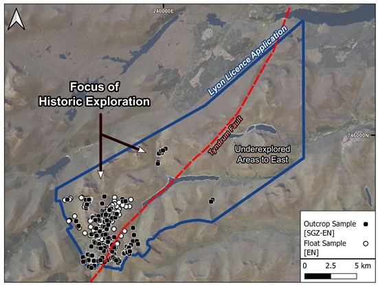
Figure 1. Aerial imagery of the Lyon licence application showing the distribution of historic rock-grab sampling, its relationship to the Tyndrum Fault, and the extensive underexplored ground to the east.
To view an enhanced version of this graphic, please visit:
https://images.newsfilecorp.com/files/9801/283134_e3a32ce6c4e0b9ec_002full.jpg
A total of 445 outcrop and 177 float-boulder rock chip samples were collected by Ennex International ("EN") and Scotgold Resources ("SGZ"), with the most extensive fieldwork being conducted in the western portions of the Lyon licence application (Figure 1 above). Full multi-element data is available for the SGZ outcrop samples (n = 316), with the remaining EN (n = 306) outcrop and float-boulder samples only assayed for gold, silver, copper, zinc and lead. Where descriptions are available, all high-grade gold bearing samples generally describe sheared or brecciated quartz-sulphide veining dominated by pyrite and lesser base-metal sulphides.
Rock grab highlights (Figure 2) include:
All sampled quartz-veins are enriched in gold above background levels.
101 samples graded ≥ 1 g/t Au.
46 samples graded ≥ 10 g/t Au.
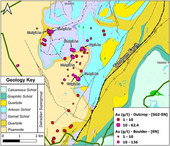
Figure 2. Aerial imagery of the Lyon licence application showing the distribution of historic rock-grab sampling, its relationship to the Tyndrum Fault, and the extensive underexplored ground to the east.
To view an enhanced version of this graphic, please visit:
https://images.newsfilecorp.com/files/9801/283134_e3a32ce6c4e0b9ec_003full.jpg
Drainage Data
A total of 205 drainage samples, including 181 stream sediment ("SS") and 24 panned concentrates ("PC") were collected by SGZ, EN and the British Geological Survey ("BGS") (Figure 3). Full multi-element data is available for the SGZ and BGS samples, with the remaining EN PC samples only assayed for gold.
Drainage highlights (Figure 3) include:
Visible gold recorded in EN PC samples, with 11 samples ≥ 0.1 g/t Au.
c. 10% of SS samples are highly anomalous in gold (≥ 0.1 g/t Au).*
*Note: Ionic Leach (IL) samples excluded from this calculation.
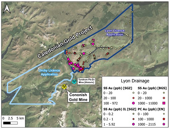
Figure 3. Aerial image of Caledonian Gold Project, including the Orchy & Lyon licence applications, showing the distribution of historic drainage sampling, including both stream sediment and panned concentrate. Note: two sets of SGZ data are differentiated based on analytical technique, with 'IL' standing for ionic leach.
To view an enhanced version of this graphic, please visit:
https://images.newsfilecorp.com/files/9801/283134_e3a32ce6c4e0b9ec_004full.jpg
Key Future Objectives
Boots-on-the-ground exploration is planned to verify historic high-grade outcrops and extend work into the underexplored eastern portion of the licence application, followed by targeted backpack drilling and channel sampling.
Detailed vein mapping and modern structural analysis will be undertaken to refine the understanding of vein morphology and controls on gold mineralisation.
A regional drainage sampling programme will be carried out to confirm historic anomalies and broaden the search area, incorporating PC sampling to provide real-time validation of gold-bearing streams alongside laboratory assays.
Large-scale soil grids will be deployed across areas with confirmed high-grade gold veining to help define the strike extent and continuity of mineralised structures.
Airborne and/or ground-based geophysics-including a potential drone-mounted magnetics survey-will be used to expand known prospects and identify additional targets or concealed anomalies.
Appendix
Table 1. Geospatial data for backpack drilling within the Lyon licence application. Coordinates in British National Grid (BNG). All samples are from surface and true-widths are unknown but expected to be > 70% of the reported interval.
| Prospect | Sample
Type | Au Grade (g/t) | Interval (m) | Easting (m) | Northing (m) |
| Creag Sheileach | Backpack drill | 25.46 | 1.0 | 234784 | 738791 |
| Coire a'Ghabhalach | Backpack drill | 25.5 | 1.0 | 232844 | 739787 |
| Backpack drill | 15.2 | 2.1 | 232889 | 739789 |
Geology
The Lyon area is underlain by the Dalradian Supergroup, a thick package of metasedimentary rocks that were deformed and metamorphosed during the Ordovician Grampian Orogeny. Subsequent late-Caledonian strike-slip tectonism during the Silurian-Devonian created major NE-SW fault corridors and drove emplacement of high-K calc-alkaline intrusions-both key ingredients in forming high-grade gold-silver quartz-sulphide veins throughout the district.
Importantly, age-dating from the Cononish deposit indicates gold mineralisation occurred around 410-406 Ma, coincident with a regional shift to transtensional tectonics, a setting known to enhance fluid flow and vein development. This same fertile geological environment underpins the exploration potential of the Lyon licence application.
About Western Gold Exploration
The Company is a mineral exploration company that is listed on the TSX Venture Exchange under the symbol "WGLD". The Company is focused on the exploration of gold, silver and critical mineral in Scotland.
In November 2025, WGLD formed the Glen Lyon Joint Venture with Acrux Gold Limited to explore for gold, silver, and critical minerals as part of the Caledonian Gold Project in central Scotland. The JV has applied for two Crown Estates Mines Royal Option Agreements (exploration licences) across the Tyndrum Mineral District, specifically the Orchy and Lyon license areas, which form the Caledonian Gold Project. The Company also operates at the Lorne Project, which include both Lagalochan and Ardlochan prospects, and are located in the highly prospective Lorne Porphyry District of the wider Caledonian belt.
For further information, please contact:
Review by Qualified Person, Quality Control and Reports
David Pym (CGeol), a consultant of the Company, is the Qualified Person (as defined by National Instrument 43-101) who supervised, verified and approved the scientific and technical disclosure in this press release on behalf of the Company. The results presented in this press release are historical in nature and assay results have not been checked consistently against assay certificates, nor is there significant QAQC information available. Some of the locations have been field checked and verified, but others haven't. As such the results are considered to represent the exploration potential of the area and are not considered to be representative.
There is no available record of the analytical methods employed by EN during the 1980s for precious or base metals. Data from the BGS was collected as part of the Mineral Reconnaissance Programme and later incorporated into the GBASE database. BGS stream sediment samples were collected from active streams, dried, and sieved to produce a fine fraction of less than 150 µm. Silver and base metals were analysed using Direct Current Optical Emission Spectroscopy (DCOES) with variable detection limits typically in the range of 1-10 ppm, while gold was analysed on a limited basis using fire assay of 30 g dried pulps followed by Atomic Absorption Spectroscopy (AAS).
SGZ conducted two stream sediment programs in the area, the first between 2010 and 2015 and the second from 2018 to 2020, using distinct analytical techniques. All SGZ stream sediment samples were sieved to 150-200 µm prior to laboratory preparation. In the first program, gold was analysed on dried pulps using aqua regia digestion with an ICP-MS finish (Au-TL43, detection limit 0.001 ppm), while silver and base metals were analysed following a four-acid digestion with an ICP-OES finish (ME-MS61). In the second program, samples were analysed using a partial sodium cyanide leach (ionic-leach) with an ICP-MS finish, yielding a gold detection limit of 0.01 ppb.
All SGZ rock-chip samples were grab samples and therefore may not be representative. The backpack drill samples were drilled with a small core rig and are best viewed as equivalent to continuous channel samples. The grab and the backpack drill samples were analysed for gold using fire assay on 30 g pulps with an AAS finish, while silver and base metals were analysed using aqua regia digestion with an ICP-AES finish. All SGZ samples were analysed at ALS Global, Ireland. ALS Geochemistry laboratories operate under a single Global Geochemistry Quality Manual compliant with ISO/IEC 17025:2017 and utilise a global laboratory information management system (LIMS), ensuring high-quality and reproducible results.
CAUTIONARY STATEMENT REGARDING FORWARD-LOOKING STATEMENTS: This news release includes certain "forward-looking statements" under applicable Canadian securities legislation. Forward-looking statements include, but are not limited to, statements with respect to timing and receipt of the Crown Estates Mines Royal Option Agreements (exploration licences) applied for by the JV, timing and completion of any drilling and work programs on the properties of the Company and the proposed properties of the JV, estimates of mineralisation from drilling and sampling, geological information projected from drilling and sample results, potential for minerals and/or mineral resources, and statements regarding the plans, intentions, beliefs, and current expectations of the Company and the JV with respect to the future business activities and operating performance of the Company and the JV that may be described herein. Forward-looking statements consist of statements that are not purely historical, including any statements regarding beliefs, plans, expectations or intentions regarding the future. Such information can generally be identified by the use of forwarding-looking wording such as "may", "expect", "estimate", "anticipate", "intend", "believe" and "continue" or the negative thereof or similar variations. Readers are cautioned not to place undue reliance on forward-looking statements, as there can be no assurance that the plans, intentions or expectations upon which they are based will occur.
By their nature, forward-looking statements involve numerous assumptions, known and unknown risks and uncertainties, both general and specific, that contribute to the possibility that the predictions, estimates, forecasts, projections and other forward-looking statements will not occur. These assumptions, risks and uncertainties include, among other things, the state of the economy in general and capital markets in particular, accuracy of assay results, geological interpretations from drilling results, timing and amount of capital expenditures; performance of available laboratory and other related services, future operating costs, and the historical basis for current estimates of potential quantities and grades of target zones, as well as those risk factors discussed or referred to in the Company's Management's Discussion and Analysis for the year ended December 31, 2024, and the period ended September 30, 2025 available at www.sedarplus.ca, many of which are beyond the control of the Company. Forward-looking statements contained in this press release are expressly qualified by this cautionary statement.
The forward-looking statements contained in this press release are made as of the date of this press release. Except as required by law, the Company disclaims any intention and assumes no obligation to update or revise any forward-looking statements, whether as a result of new information, future events or otherwise. Additionally, the Company undertakes no obligation to comment on the expectations of, or statements made by, third parties in respect of the matters discussed above.
Neither the TSX Venture Exchange nor its Regulation Service Provider (as that term is defined in the policies of the TSX Venture Exchange) accepts responsibility for the adequacy or accuracy of this release.
To view the source version of this press release, please visit https://www.newsfilecorp.com/release/283134

© 2026 Canjex Publishing Ltd. All rights reserved.