(via TheNewswire)
Vancouver, British Columbia - TheNewswire - September 14, 2026: Red Canyon Resources Ltd. (“Red Canyon” or the “Company”) (CSE: REDC | OTCQB: REDRF | Frankfurt: I91) is pleased to announce the completion of its auger drilling and expanded soil geochemistry programs at its 100% owned Osiris Copper-Gold Project (“Osiris”) in central British Columbia.
Company Highlights:
The Company completed 31 truck-mounted auger drill holes testing areas at the Camp, Twin Peaks, Rhino, and Nautilus targets, all under glacial till cover. In most cases, auger drill holes were able to penetrate up to 15 cm into the bedrock and recover chip samples. Importantly, two holes at the northern end of Nautilus drilled into altered hornblende porphyry, one of which intersected quartz veining with pyrite and chalcopyrite.
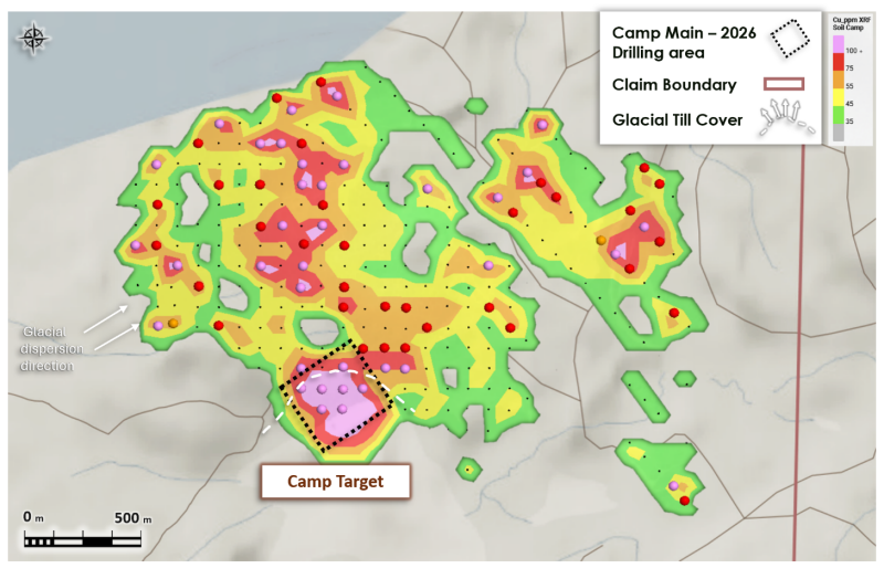
At Camp, 313 additional soil samples were collected to expand the Company’s understanding of the mineral system identified through recent diamond drilling. Preliminary field portable X-ray fluorescence (“pXRF”) analyses outline a NNW-trending zone of anomalous copper and other porphyry-indicator elements extending more than 2.0 km from the recently drilled Camp Main area.
At Nautilus, 407 conventional soil samples were collected over key areas of the 3.5 × 3.5 km complex magnetic feature. Preliminary pXRF field analyses outline a broad, large-scale zone of anomalous copper and other porphyry-indicator elements over several priority areas despite the extensive glacial till cover.
A new area of interest at the northern end of the Nautilus magnetic feature has returned highly anomalous pXRF values in multiple copper porphyry-indicator elements and is now a new priority target for the Company.
The Company has engaged Scott Geophysics to expand the IP survey at Nautilus, including new lines over the northern magnetic features and areas of elevated preliminary geochemistry.
Wendell Zerb, the Chairman and CEO of the Company, commented: “We are very encouraged by the results of our expanded exploration program at Osiris. The recent Camp drilling has confirmed the presence of an altered and copper and gold-bearing porphyry system, and our new geochemistry, combined with the existing geophysical data, indicates that this system continues for more than 2.0 km to the north-northwest. This provides us with a much larger exploration footprint than was previously recognized.
At Nautilus, we are particularly encouraged by the scale of the preliminary pXRF results. Despite significant glacial till cover, our expanded soil program has outlined a broad copper and porphyry-indicator geochemical trend across multiple areas within the 3.5 km by 3.5 km magnetic feature. The northern portion of Nautilus has emerged as a new area of focus, where multiple magnetic features coincide with elevated geochemistry, and auger drilling has now identified altered porphyritic rocks, including chalcopyrite mineralization.
The combination of geochemistry, magnetics, IP and the geological information from our auger drilling is providing an increasingly compelling exploration model at Nautilus. We have therefore expanded the IP survey to the north to further define these targets and determine the priority areas for future drill testing.”
Red Canyon Projects
The Company holds a portfolio of seven 100%-owned 1 projects in British Columbia and the western United States. High-priority projects are Kendal in west-central British Columbia, Inzana (Osiris and Acheron) in central British Columbia, and Scraper Springs in northeast Nevada.
Osiris Project
The Osiris Project forms the central and northern part of the Inzana project area. The Inzana project area is in central British Columbia, approximately 60 km northwest of the district municipality of Fort St. James and 35 km west-southwest of Centerra Gold’s Mount Milligan copper-gold mine. The area has excellent access, provided by primary and secondary forestry roads.
The Osiris Project is located within the early Mesozoic-aged Quesnellia island arc terrane, which hosts several of British Columbia’s largest copper and copper-gold deposits. The project is bounded to the west by the NW-trending Pinchi Fault and includes interpreted NE-SW cross-arc structures that the Company believes may represent important structural pathways for the emplacement of porphyry systems.
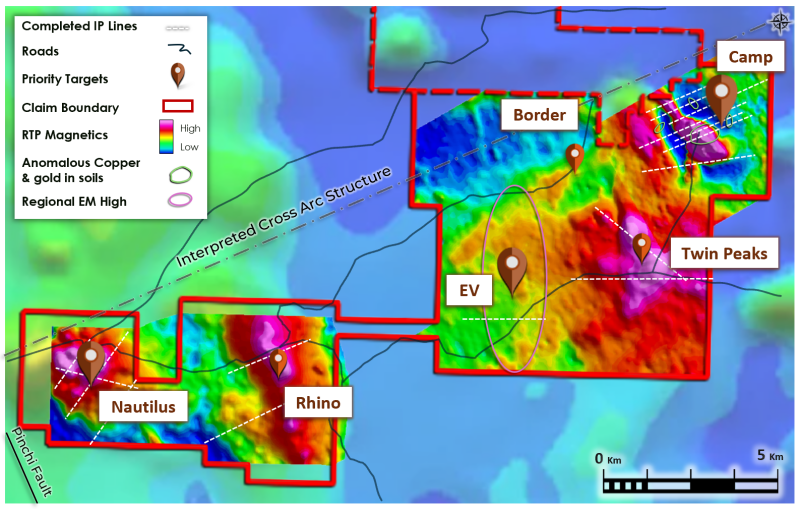
In 2025, Red Canyon contracted Precision Geosurveys to conduct project-wide airborne magnetic and radiometric surveys. Fathom Geophysics completed data filtering and Magnetic Vector Inversion (“MVI”) modelling. This year, Scott Geophysics completed 38 line-km of dipole-dipole IP surveys over several priority target areas.
The Company has identified several priority targets at Osiris, including Camp, Nautilus, EV, Twin Peaks and Rhino.
Click Image To View Full Size
Figure 1: Osiris Project, targets for 2026 fieldwork, completed IP lines and the Camp target location.
Auger Drilling Program
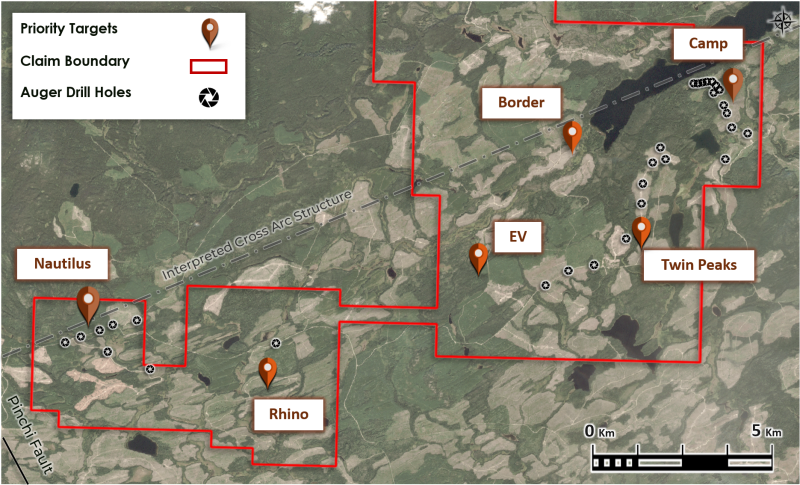
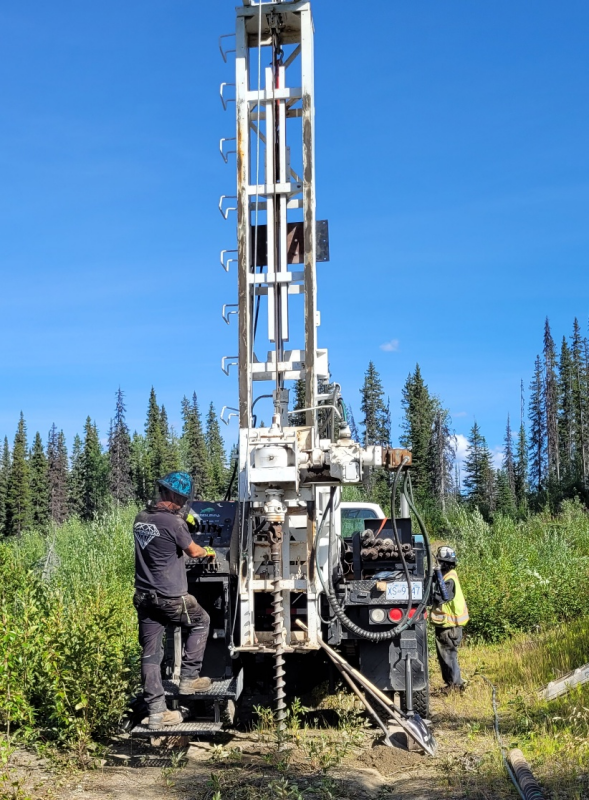
The Company completed 31 truck-mounted auger drill holes across the Camp, Twin Peaks, Rhino and Nautilus target areas. The program was completed by Diamondhead Drilling using a truck-mounted, low-impact, auger drilling system designed to penetrate glacial till and obtain basal till samples and bedrock chip samples.
The program was focused on road-accessible areas where the Company considered the combination of geological, geochemical and geophysical information to warrant additional subsurface investigation. Glacial till thickness varied from approximately 2 - 20 m across the areas tested.
Click Image To View Full Size
Figure 2: Area outlining location of auger drill holes.
At each drill site, approximately 0.5 kg of sample was collected from the base of the till and/or bedrock chips, where encountered. Samples were analyzed in the field using pXRF instrumentation, logged and photographed by Company geologists, and subsequently submitted to an independent laboratory for assay.
The pXRF results discussed in this release are preliminary field analyses and should not be considered equivalent to laboratory assays. Laboratory assays for the auger and soil samples are pending and are expected during Q4 2026.
Two auger holes completed at the northern end of the Nautilus magnetic feature intersected altered hornblende porphyry. One of the holes also intersected quartz veining containing pyrite and chalcopyrite. The identification of altered porphyritic rocks containing chalcopyrite beneath the glacial till provides additional confidence that magnetic and soil geochemical features at northern Nautilus could be associated with a mineralized copper-gold porphyry system.
The auger results are particularly significant because the Nautilus target is covered by significant glacial till, limiting the effectiveness of conventional surface geological sampling. The auger program provided the Company with an opportunity to directly investigate the bedrock beneath this cover and determine the geological character of the magnetic and geochemical anomalies.
Click Image To View Full Size
Figure 3: Photo Auger drilling at Camp north area
Camp Copper-Gold Porphyry Target
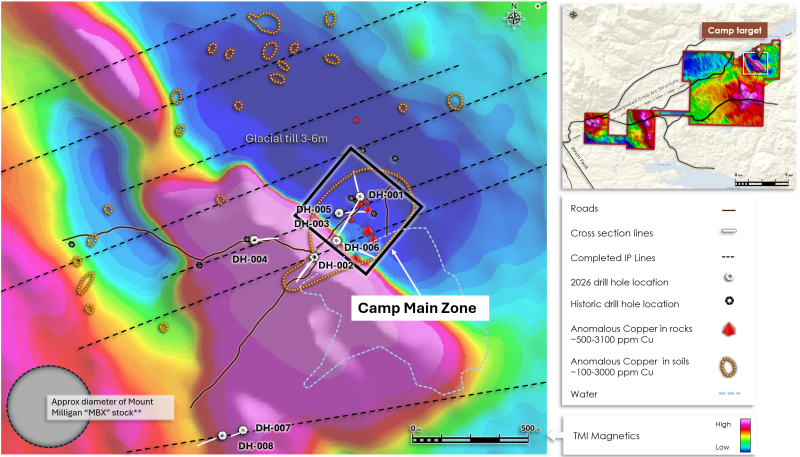
The Camp target is associated with an approximately 2.75 × 2.25 km NNW-trending magnetic feature with a strong central magnetic core surrounded by a larger remanent magnetic halo (Figure 4). Recent diamond drilling indicates that the principal magnetic core is associated with a magnetite-rich pyroxenite intrusive complex interpreted to represent an early phase of an alkalic copper-gold system.
The Company completed eight diamond drill holes totalling 2,079 metres at Camp during the initial 2026 drill program, largely testing the Camp Main area (see Red Canyon News Release dated July 30, 2026). Based on geological observations from drilling, the Company interprets Camp to host an alkalic copper-gold mineral system with geological similarities to alkalic copper-gold systems elsewhere in British Columbia, including the Mount Polley and Mount Milligan systems*.
Diamond drilling intersected variably altered and mineralized porphyritic rocks and multiple alteration assemblages characteristic of alkalic copper-gold systems. Copper mineralization was observed as disseminations and in veinlets and fractures, commonly associated with calc-potassic alteration. Assay results are pending and expected to be completed in early Q4 2026.
Expanded IP coverage at Camp has outlined NNW-trending resistivity and chargeability features extending approximately 2.0 km from the Camp Main Zone. These features occur east of the pyroxenite intrusive complex and are parallel to a NW-trending, east-dipping structure interpreted to potentially represent a long-lived fluid pathway.
Click Image To View Full Size
Figure 4: Camp target with TMI magnetics, 2026 drill hole locations, location reference Camp Main.
The Company completed 313 additional soil samples to expand geochemical coverage around Camp and along the interpreted NNW-trending extension of the mineral system.
Preliminary field pXRF analyses have outlined a trend of anomalous copper and other porphyry-indicator elements extending to the NNW from the recently drilled Camp area. The geochemical trend corresponds with previously identified geophysical and structural features and provides additional support for the Company’s interpretation that the Camp mineral system extends beyond the area tested by the initial drilling (Figure 5).
Click Image To View Full Size
Figure 5: The Camp target highlighting expanded preliminary pXRF analyzed copper anomalous soils.
Nautilus Copper-Gold Target
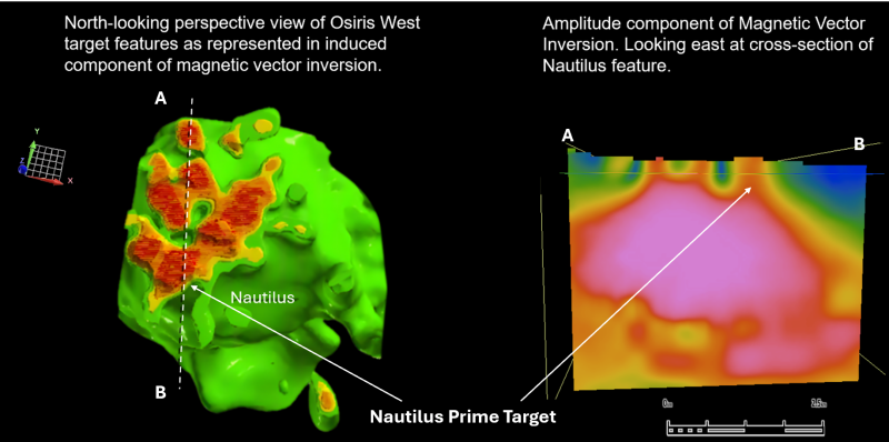
Nautilus is characterized by a complex magnetic feature measuring approximately 3.5 × 3.5 km. Previous MVI modelling identified multiple pipe-like magnetic features interpreted by the Company as possible porphyry intrusions emanating from a larger magnetic body at depth (s ee Red Canyon News Release dated July 30, 2026).
Click Image To View Full Size
Figure 6: Magnetic Vector Inversion model of Nautilus target areas.
Initial IP survey lines completed at Nautilus identified high-priority areas characterized by coincident magnetic highs, high resistivity and moderate to high chargeability. The Company interprets these signatures as potentially representing altered and mineralized porphyry intrusions.
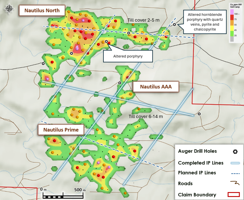
The Company completed 407 soil samples covering key areas across the Nautilus magnetic feature. Sampling was designed to test areas where magnetic, IP and geological interpretations indicated potential for porphyry mineralization.
Click Image To View Full Size
Figure 7: The Nautilus target highlighting preliminary pXRF analyzed copper anomalous soils.
Preliminary field pXRF analyses have outlined a broad zone of anomalous copper and other porphyry-indicator elements across portions of the Nautilus target. The geochemical response is significant given the extensive glacial till cover across the area, which has the potential to mask conventional surface geochemical responses. Based on recent auger drilling, glacial till cover is 2-5 m at the northern extent of Nautilus and increases to as deep at 14 m in the central area of the Nautilus magnetic feature.
A new high-priority target area has been identified at the northern end of the Nautilus magnetic feature (Nautilus North), where preliminary pXRF analyses outline highly anomalous copper porphyry indicator elements that correlate directly with several distinct magnetic anomalies.
Nautilus Expanded IP Survey
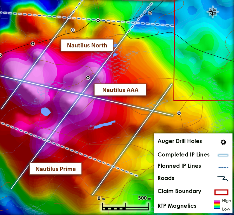
The Company has engaged Scott Geophysics to expand the existing IP survey at Nautilus. The expanded survey will include approximately 6 km of new lines including across the northern magnetic features and a cross line on the Nautilus Prime target. The Survey is scheduled to begin mid-September.
The objective of the expanded IP program is to further define the geometry, continuity and depth extent of the geophysical anomalies and determine priority targets for future diamond drill testing. The Company believes the integration of the magnetic, IP, geochemical and auger drilling results will provide an increasingly robust geological and geophysical framework for evaluating the Nautilus targets.
Click Image To View Full Size
Figure 8: The Nautilus target area highlighting expanded IP lines. Base map RTP airborne Magnetics.
Newly constructed forestry roads and cut blocks have significantly improved access to the Nautilus Prime and AAA target areas, enabling completion of a new soil and till geochemistry program. Active logging is now completed, leaving behind new access routes for exploration programs including diamond drilling. The northern area of Nautilus has excellent road access, and adjacent inactive logging roads available for re-establishing track access.
About Red Canyon Resources
Red Canyon Resources Ltd. (CSE: REDC) is a technically driven, discovery-focused mineral exploration company exploring North America’s top copper jurisdictions. The Company’s core goal is to make impactful copper discoveries and has a portfolio of 100% owned copper and copper-gold porphyry exploration projects.
The Company’s technical team consists of experienced geoscientists with diverse capital market, junior, and major mining company backgrounds and a track record of success.
For more information, please visit the Company's website at www.redcanyonresources.com.
Red Canyon is part of the NewQuest Capital Group which is a discovery-driven investment company that builds value through the incubation and financing of mineral projects and companies. Further information about NewQuest can be found on the company website at www.nqcapitalgroup.com .
1 Red Canyon has two projects subject to option earn in agreements whereby the Company can earn into 100% of the project.
The Canadian Securities Exchange does not accept responsibility for the adequacy or accuracy of this news release.
Qualified Person :
The technical information contained in this update has been reviewed and approved by Wendell Zerb, P. Geol, a “Qualified Person” (“QP”) as defined in National Instrument 43-101 – Standards of Disclosure for Mineral Projects. Mr. Zerb is not independent by reason of being the Chairman, President and CEO of the Company. In presenting examples in this release for comparison including the Mount Polley Mine and the Mount Milligan Mine in British Columbia, the Company in no way implies that future exploration will necessarily result in the discovery of similar economic mineral deposits. *The Qualified Person has not verified the information on the mineral systems at these mines and the information disclosed is not necessarily indicative of mineralization on Red Canyon projects. Portable XRF Analysis: Preliminary geochemical results discussed in this news release include field measurements obtained using a handheld portable X-ray fluorescence (“pXRF”) analyzer. The pXRF data are considered preliminary and are being used as a field screening tool to identify areas of anomalous copper and other porphyry-indicator elements and to assist in guiding ongoing exploration. The pXRF measurements have not been independently verified and should not be considered equivalent to, or a substitute for, laboratory assay results. All samples have been submitted to an independent laboratory for conventional analysis, with results pending.
Qualified Person :
The technical information contained in this update has been reviewed and approved by Wendell Zerb, P. Geol, a “Qualified Person” (“QP”) as defined in National Instrument 43-101 – Standards of Disclosure for Mineral Projects. Mr. Zerb is not independent by reason of being the Chairman, President and CEO of the Company. *The Qualified Person has not verified the information on the mineral systems at these mines and the information disclosed is not necessarily indicative of mineralization on Red Canyon projects. Portable XRF Analysis: Preliminary geochemical results discussed in this news release include field measurements obtained using a handheld portable X-ray fluorescence (“pXRF”) analyzer. The pXRF data are considered preliminary and are being used as a field screening tool to identify areas of anomalous copper and other porphyry-indicator elements and to assist in guiding ongoing exploration. The pXRF measurements have not been independently verified and should not be considered equivalent to, or a substitute for, laboratory assay results. All samples have been submitted to an independent laboratory for conventional analysis, with results pending.
FORWARD-LOOKING STATEMENTS
This news release includes certain forward-looking statements and forward-looking information (collectively, “forward-looking statements”) within the meaning of applicable Canadian securities legislation. All statements, other than statements of historical fact, included herein including, without limitation, statements regarding future capital expenditures, exploration activities and the specifications, targets, results, analyses, interpretations, benefits, costs and timing of them, and the anticipated business plans and timing of future activities of the Company, are forward-looking statements. Although the Company believes that such statements are reasonable, it can give no assurance that such expectations will prove to be correct. Often, but not always, forward looking information can be identified by words such as “pro forma”, “plans”, “expects”, “may”, “should”, “budget”, “scheduled”, “estimates”, “forecasts”, “intends”, “anticipates”, “believes”, “potential” or variations of such words including negative variations thereof, and phrases that refer to certain actions, events or results that may, could, would, might or will occur or be taken or achieved. Forward-looking statements involve known and unknown risks, uncertainties and other factors which may cause the actual results, performance or achievements of the Company to differ materially from any future results, performance or achievements expressed or implied by the forward-looking statements. Such risks and other factors include, among others, risks related to the anticipated business plans and timing of future activities of the Company, including the Company’s exploration plans and the proposed expenditures for exploration work thereon, the ability of the Company to obtain sufficient financing to fund its business activities and plans, the ability of the Company to obtain the required permits, changes in laws, regulations and policies affecting mining operations, the Company’s limited operating history, currency fluctuations, title disputes or claims, environmental issues and liabilities, as well as those factors discussed under the heading “Risk Factors” in the Company’s prospectus dated October 12, 2023 and other filings of the Company with the Canadian Securities Authorities, copies of which can be found under the Company’s profile on the SEDAR+ website at www.sedarplus.ca.
Readers are cautioned not to place undue reliance on forward-looking statements. The Company undertakes no obligation to update any of the forward-looking statements, except as otherwise required by law.

Copyright (c) 2026 TheNewswire - All rights reserved.
© 2026 Canjex Publishing Ltd. All rights reserved.