(via TheNewswire)
The first of three drill rigs has now begun drilling at the Property, following completion of a 468-metre trenching program at the SSD Target
1:5000-scale Anaconda-style mapping is ongoing across the Property and has already significantly expanded the alteration footprint at the SSD Target
Multiple geochemical sampling programs and geophysical surveys are at various stages of completion, with results forthcoming
Vancouver, British Columbia, June 22, 2026 – TheNewswire – Westward Gold Inc. (CSE: WG, OTCQB: WGLIF, FSE: IM50) (“Westward” or the “Company” ) is pleased to provide an update on field activities at the Company’s Toiyabe Hills Property in Lander County, Nevada (“Toiyabe Hills” , or the “Property” ), where drilling has just commenced and numerous additional exploration programs are currently ongoing. Following the recent receipt of a Work Plan Concurrence from the U.S. Bureau of Land Management (“BLM” ), trenching activities were completed at the SSD Target (“SSD” ), one of three zones slated for core and reverse-circulation (“RC” ) drilling in 2026 (see press release dated April 27, 2026, for an in-depth review of SSD) . The Company has just begun drilling at SSD following delivery of a core rig to site, with two RC rigs to follow in the months ahead from National EWP and Legacy Drilling. Additional large-scale programs to be completed this year include 1:5000 surface mapping, geochemical sampling, and multiple geophysical surveys; details and status updates on each are provided below.
2026 Trenching Program (SSD Target)
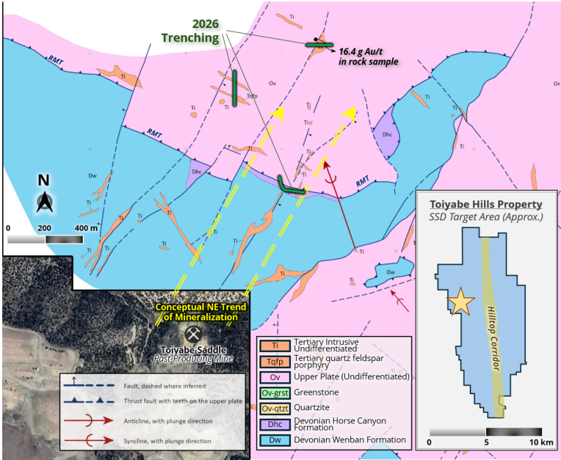
A 468-metre trenching program has just been completed at the SSD Target (see Figures 1 and 2 below), designed to more accurately sample and map structures ahead of drilling; this data will contribute to the final determination of drill hole dips / azimuths from certain planned drill sites. High-grade structures – including the dike containing a 16.4 g Au/t sample – will be projected down-section based on mapped dips and strikes, and drills will be aimed to intersect these structures within favourable carbonate host rocks (notably of the Wenban Formation). These settings typically represent the best potential for significant zones of gold mineralization in Carlin-type systems along the major trends of northern Nevada.
Figure 1: SSD Target – 2026 Trenching Program
Click Image To View Full Size
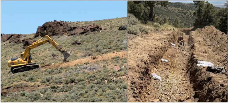
Figure 2: SSD Target – 2026 Trenching Program Photos
Click Image To View Full Size
Surface Mapping Program
The Company’s 1:5000 Anaconda-style surface mapping program has been ongoing since the beginning of the field season, and continues to form a vital part of Westward’s systematic exploration and targeting strategy. This year will see the greatest amount of new coverage ever, with three expert mappers advancing multiple folios concurrently (including recent land expansions to the north and south) – Steve Koehler (Technical Advisor), Robert Edie (VP Exploration), and Tom Chapin (Contractor).
The program has already generated important new findings, notably moving north at the SSD Target and over newly-acquired ground at the southern end of the Property:
The SSD alteration footprint has been expanded to the north and northeast of previous mapping, and surface alteration remains open in those directions.
Three distinct patterns have been verified: i) quartz veins / stockworks and silica replacements increase to the north, especially along north-, east northeast-, northeast-, and northwest-striking faults; ii) hydrothermally-altered lamprophyre and altered quartz porphyry dikes/sills occur in close proximity to one another; and iii) hematite, hematitic clay, and euhedral barite crystals are notable alteration features.
The hematite is significant for two reasons: hematite often implies a higher sulfidation state (not unlike oxide patterns in a porphyry system), and from south to north, limonite is dominant at the past-producing Toiyabe-Saddle open pits, and at the shallow Courtney Zone on the Property. Hematite occurs further to the north, in the vicinity of stronger silicification and altered quartz porphyry and lamprophyre dikes – this area is also closer to the recently-identified Threemile Stock.
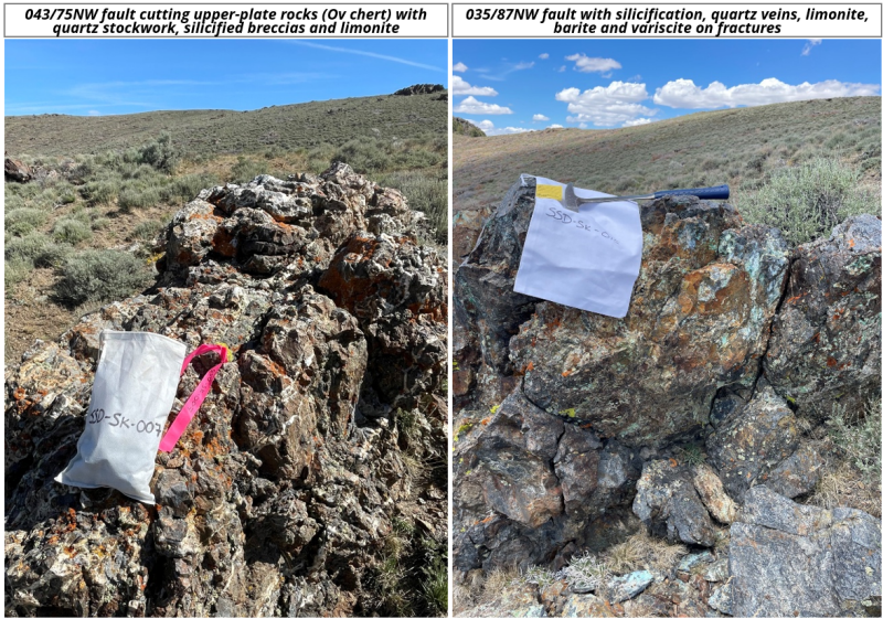
20 hydrothermally-altered outcrop and subcrop samples were collected over a ~0.8-square-kilometre area north and northeast of the northernmost SSD trench.
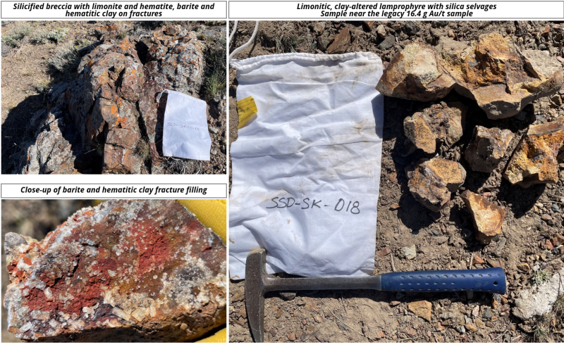
Samples represent an initial characterization of altered upper-plate siliciclastic rocks and/or intrusive material, including quartz-veined/stockworked-limonite-hematite altered fault zones, silicified fault breccias with limonite, hematite, and/or barite, and clay-altered and limonitic lamprophyres (select photos shown in Figures 3 and 4 below).
At the Company’s new southern ground (staked at the end of 2025), a series a northwest-striking altered dike-filled fault corridors have been mapped and samples have been collected.
Figure 3: Select Photos – 2026 Mapping & Sampling (Northern SSD Target Area)
Click Image To View Full Size
Figure 4: Select Photos – 2026 Mapping & Sampling (Northern SSD Target Area)
Click Image To View Full Size
Geochemical Sampling Programs
The Company’s robust 2026 geochemical sampling programs are adding to an already expansive database built over the last several years, and will include the following:
Trenching: rock-chip samples collected at regular intervals with increased frequency around observed areas of interest (collection nearing completion)
Soil Grids: collection of soil samples at 200-metre spacing across the most recently-acquired claims to the north (75% complete) and south (complete, data pending), in addition to a select in-fill grid to improve upon inherited legacy data (collection pending)
Mapping: rock-chip samples collected over the most interesting areas identified during surface mapping (collection ongoing, data pending)
Road-cuts and drill-pad earthwork: rock-chip sampling of exposures created by road and pad construction (collection ongoing, data pending)
Geophysical Surveys
Three significant geophysical surveys are being conducted by the Company in 2026 – forming another pillar of its systematically-gathered baseline exploration data. As in previous years, all results are being interpreted by Mr. Jim Wright of J.L. Wright Geophysics in Spring Creek, NV – a renowned geophysicist with over 40 years of expertise within the Carlin and Cortez Districts of northern Nevada – in coordination with Westward’s team of technical experts. This year’s programs include the following:
Airborne Magnetic Survey: a bolt-on drone magnetic survey designed to cover newly-acquired ground to the north and better define a suspected buried igneous stock identified via a 2025 survey (data acquired and processed, final interpretations pending).
CSAMT (Controlled-Source Audio-Frequency Magnetotellurics) Survey: two lines designed to provide better resolution of structures and stratigraphy at the El Segundo Target slated for Phase I drilling in 2026 (data acquired, processing and interpretations pending).
Gravity Survey: this gravity survey will add coverage over the newly-acquired ground to the north and south and tie into the existing Property-wide dataset (data acquisition expected shortly).
Qualified Person
The technical information contained in this news release was reviewed and approved by Robert Edie, Vice President Exploration of the Company, who is a Qualified Person under National Instrument 43-101 – Standards of Disclosure for Mineral Projects. Mr. Edie is a Certified Professional Geologist (CPG) through the American Institute of Professional Geologists (AIPG).
About Westward Gold
Westward Gold is a mineral exploration company focused on developing the Toiyabe Hills Project located in the Cortez Trend area of Lander County, Nevada, and the Coyote and Rossi Projects located along the Carlin Trend in Elko County, Nevada. From time to time, the Company may also evaluate the acquisition of other mineral exploration assets and opportunities.
For further information contact:
Andrew Nelson
Chief Financial Officer
Westward Gold Inc.
+1 (604) 828-7027
andrew@westwardgold.com
www.westwardgold.com
The Canadian Securities Exchange has neither approved nor disapproved the contents of this news release. The Canadian Securities Exchange does not accept responsibility for the adequacy or accuracy of this news release.
This news release contains or incorporates by reference “forward-looking statements” and “forward-looking information” as defined under applicable Canadian securities legislation. All statements, other than statements of historical fact, which address events, results, outcomes, or developments that the Company expects to occur are, or may be deemed, to be, forward-looking statements. Forward-looking statements are generally, but not always, identified by the use of forward-looking terminology such as "expect", "believe", "anticipate", "intend", "estimate”, “potential”, “on track”, “forecast", "budget", “target”, “outlook”, “continue”, “plan” or variations of such words and phrases and similar expressions or statements that certain actions, events or results “may”, “could”, “would”, “might” or “will” be taken, occur or be achieved or the negative connotation of such terms.
Such statements include, but may not be limited to, information as to strategy, plans or future financial or operating performance, such as the Company’s expansion plans, project timelines, expected drilling targets, and other statements that express management’s expectations or estimates of future plans and performance.
Forward-looking statements or information are subject to a variety of known and unknown risks, uncertainties and other factors that could cause actual events or results to differ from those reflected in the forward-looking statements or information, including, without limitation, the need for additional capital by the Company through financings, and the risk that such funds may not be raised; the speculative nature of exploration and the stages of the Company’s properties; the effect of changes in commodity prices; regulatory risks that development of the Company’s material properties will not be acceptable for social, environmental or other reasons, availability of equipment (including drills) and personnel to carry out work programs, that each stage of work will be completed within expected time frames, that current geological models and interpretations prove correct, the results of ongoing work programs may lead to a change of exploration priorities, and the efforts and abilities of the senior management team. This list is not exhaustive of the factors that may affect any of the Company’s forward-looking statements or information. These and other factors may cause the Company to change its exploration and work programs, not proceed with work programs, or change the timing or order of planned work programs. Additional risk factors and details with respect to risk factors that may affect the Company’s ability to achieve the expectations set forth in the forward-looking statements contained in this news release are set out in the Company’s latest management discussion and analysis under “Risks and Uncertainties”, which is available under the Company’s SEDAR+ profile at www.sedarplus.ca. Although the Company has attempted to identify important factors that could cause actual results to differ materially, there may be other factors that cause results not to be as anticipated, estimated, described or intended. Accordingly, readers should not place undue reliance on forward-looking statements or information. The Company’s forward-looking statements and information are based on the assumptions, beliefs, expectations, and opinions of management as of the date of this press release, and other than as required by applicable securities laws, the Company does not assume any obligation to update forward-looking statements and information if circumstances or management’s assumptions, beliefs, expectations or opinions should change, or changes in any other events affecting such statements or information.
Copyright (c) 2026 TheNewswire - All rights reserved.
© 2026 Canjex Publishing Ltd. All rights reserved.