Regional geochemical soil sampling highlights a large and untested copper anomaly parallel to the Storm trend
Highlights:
New, greater than four-kilometre ("km") long copper anomaly discovered: The regional soil geochemistry program has defined a very strong, high-priority 4.1km by 0.7km copper anomaly, now named the Chevron Prospect.
High-priority target: The geological features of the Chevron Prospect are similar to those that host the known copper deposits in the Storm area - including a similar geochemical signature and structural trend - making Chevron a compelling target for a major new copper discovery.
Squall high-grade copper zone expanded: Assays confirm further high-grade copper sulphides at the Squall Prospect, which show a similar setting and style of mineralization to the Corona Copper Deposit, 1.3Km to the east, including drill hole SR25-012, which intersected:
4.5m @ 1.4% copper ("Cu"), 2.6 grams per tonne (g/t) silver ("Ag") from 158.5 metres ("m"), including:
1.5m @ 3.6% Cu, 5.0 g/t Ag from 158.5m
Copper sulphides intersected in the Tornado area, confirming prospectivity: Widespread copper has been intersected in drilling within the prospective Allen Bay Formation and extensive fault network in the Tornado area, confirming the prospectivity of this high-priority exploration area.
TORONTO, ON / ACCESS Newswire / November 17, 2025 / Aston Bay Holdings Ltd. (TSXV:BAY)(OTCQB:ATBHF) ("Aston Bay" or the "Company") is pleased to provide an update on exploration activities at the Storm Copper Project ("Storm" or the "Project") on Somerset Island, Nunavut. American West Metals Limited ("American West"), the Project operator, is conducting the exploration program. Aston Bay and American West have formed a 20/80 unincorporated joint venture with respect to the Storm Project property, with Aston Bay maintaining a free carried interest until a decision to mine is made upon completion of a bankable feasibility study.
Thomas Ullrich, Chief Executive Officer of Aston Bay,commented:
"We are very excited by this discovery of a new Storm-sized copper anomaly at our Project on Somerset Island. At the main Storm area, a similar copper-in-soil anomaly sits above a significant near-surface copper resource, as well as above several other deeper copper discoveries. The newly identified Chevron area shows similar potential. This four-kilometre trend has seen no significant surface sampling to date, and no geophysics or drilling has ever been conducted. The follow-up exploration will add significant discovery potential to next season's program, in addition to the compelling targets already defined by this year's helicopter-borne Mobile Magnetotelluric geophysical survey.
"The positive results from this season's reverse circulation ("RC") drilling program also continue to demonstrate the prospectivity and expansion potential at the main Storm area.
"These discoveries speak to the still-untapped exploration potential of the Project. It is thrilling to advance the development activities for the Storm resource while adding potential value through discovery each season. "
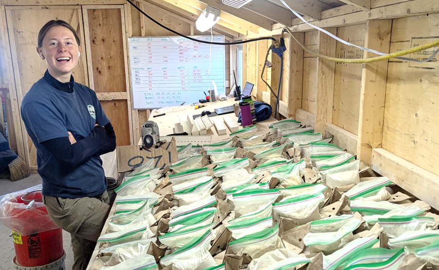
Figure 1: Sample preparation onsite at the Storm Camp, Storm Project, Nunavut.
REGIONAL SOIL SAMPLING IDENTIFIES EXTENSIVE COPPER ANOMALIES
An extensive mapping and soil geochemical sampling program has been completed throughout the project claims. The soil program was designed using new targeting information from the recent project-wide technical review. The soil grids consisted of varying sample spacings and are primarily focused around lithological and structural targets that were previously untested and could be analogous to the known deposit areas at Storm. 1,957 samples were collected over eight survey areas (see Figures 2 through 4).
Along with the strong regional north-south structural trend linking Storm to the past-producing Polaris Lead-Zinc mine, the district-scale mineralization model at the Storm project also suggests that copper (and other base metal) mineralization may be regionally controlled by the large WNW trending faults that cut through the project area, with a similar orientation to that of the main grabens at Storm and Tornado. These features can be recognized across the region, along the trend known as the Aston-Batty line. The Nanisivik Lead-Zinc mine on Baffin Island is interpreted to be located within this trend. Significantly, base metal mineralization at Storm occurs at the intersection of the N-S (Polaris) and WNW (Nanisivik) trends.
The 2025 soil program targeted several of these features, one of which has highlighted a 4.1km by 0.7km copper anomaly (Figure 3). The strength of the new anomaly, now named the Chevron Prospect, is interpreted as highly anomalous based on historic surveys (over 13,000 soil samples), and it is similar to that of the known copper deposits in the Storm area. The anomaly contains a coherent, 2km long core with values exceeding 250 parts per million ("ppm") Cu, showing a strong correlation with other pathfinder elements, including zinc and lead.
While rock and gossan sampling of copper sulphides at surface typically show copper values very close to the presumed source copper mineralization, it is essential to note that the amount of geochemical dispersion of metals within the soil at Storm is limited by the restricted geochemical mobility (due to reactive carbonate rocks), lack of gravitational dispersion (flat surface) and permafrost. Most soil anomalies are much more subtle than rock samples and are located either above or immediately adjacent to the sulphide source and stratigraphic host location.
New exploration claims are now under application east of the Chevron Prospect to cover the prospective ground along strike from the newly defined target area. The project now covers an area of approximately 2,300 square kilometres.
The latest success at the Chevron prospect validates the program-wide target generation work and has discovered another high-priority target for further exploration in the region. The Chevron Prospect has not been covered with geophysics (neither electromagnetics (EM) nor magnetotellurics (MT)) or drilling, and will require focused follow-up exploration. With over 110km of strike length known to host copper mineralization, the discovery of the Chevron area highlights that the project still remains relatively underexplored.
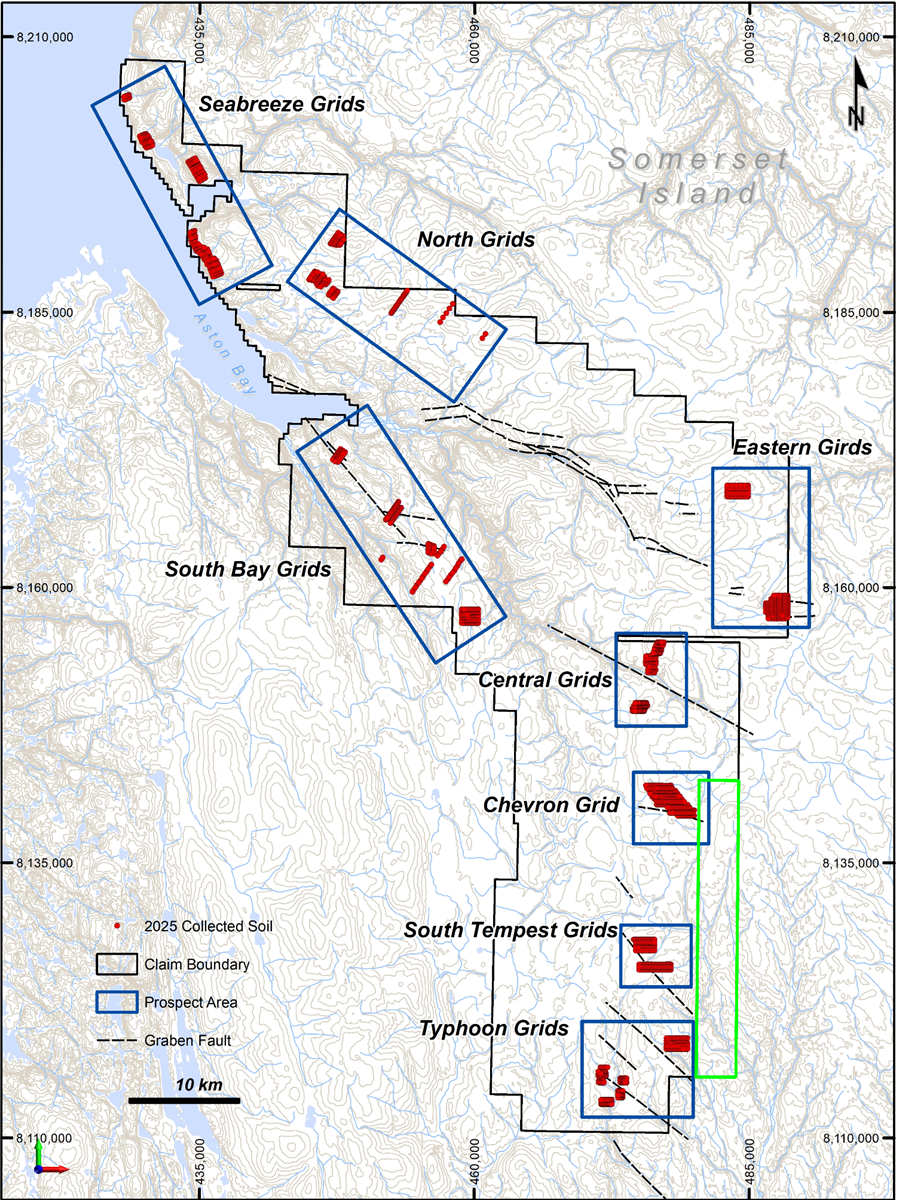
Figure 2: Regional soil sampling program sample locations overlaying regional topographic map. The green polygon shows the additional claim area under application.
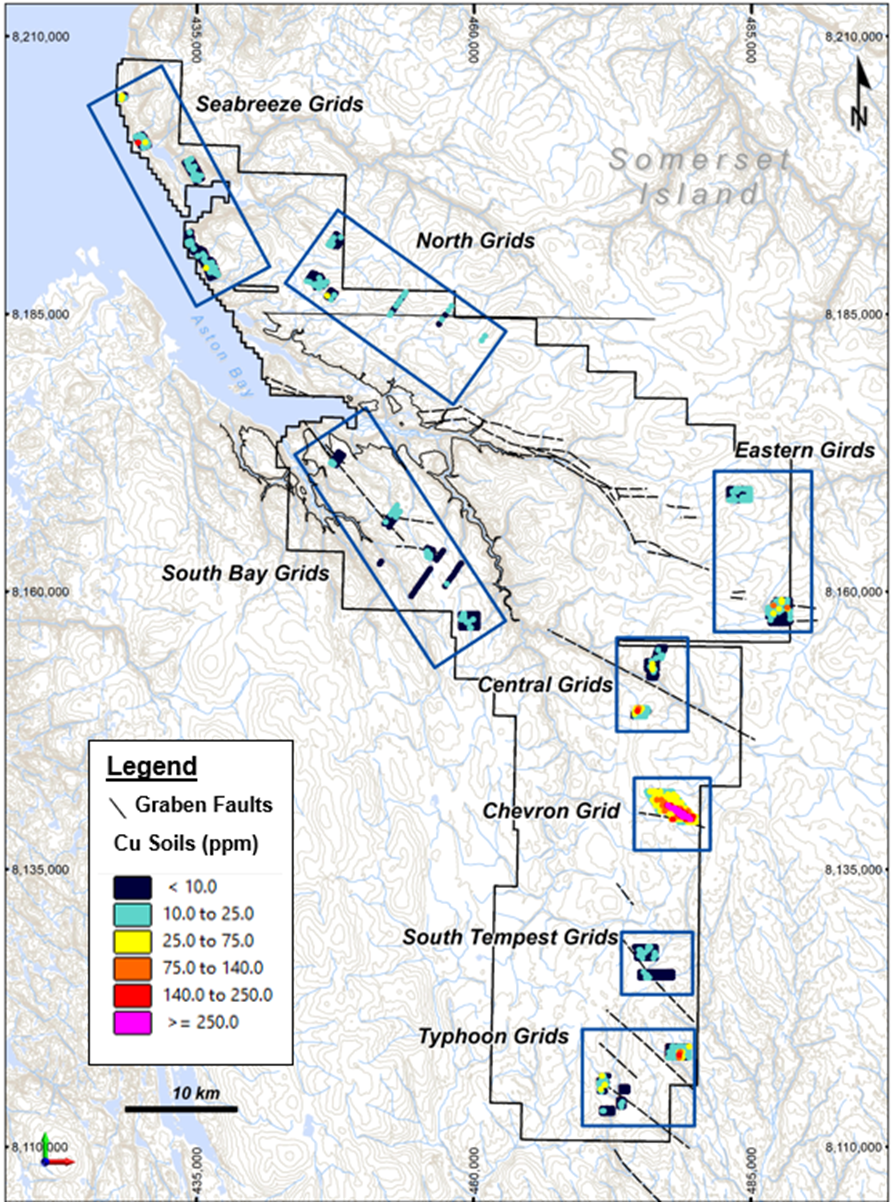
Figure 3: Regional soil sampling program showing maximum copper values, overlaying regional topographic map.
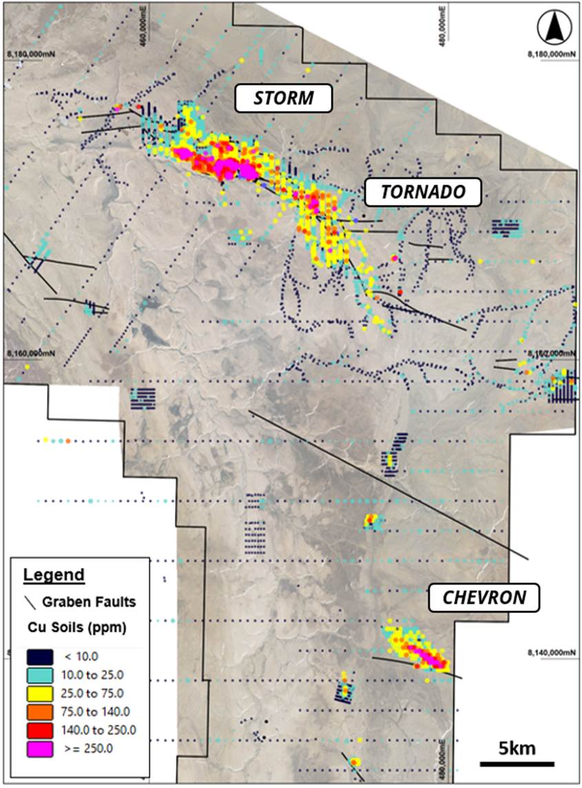
Figure 4: Historical and recent geochemical samples showing maximum copper values of the Storm-Tornado and Chevron areas. The Chevron anomaly shows similar strength and structural orientation to the Storm and Tornado areas.
STORM REVERSE CIRCULATION EXPLORATION DRILLING
Eight drill holes were completed for exploration purposes in the Storm area, including the areas surrounding the known copper deposits. The areas that were tested include the Squall and Hailstorm Prospects, the Gap Prospect, and along strike of the Cyclone Deposit (Figure 5).
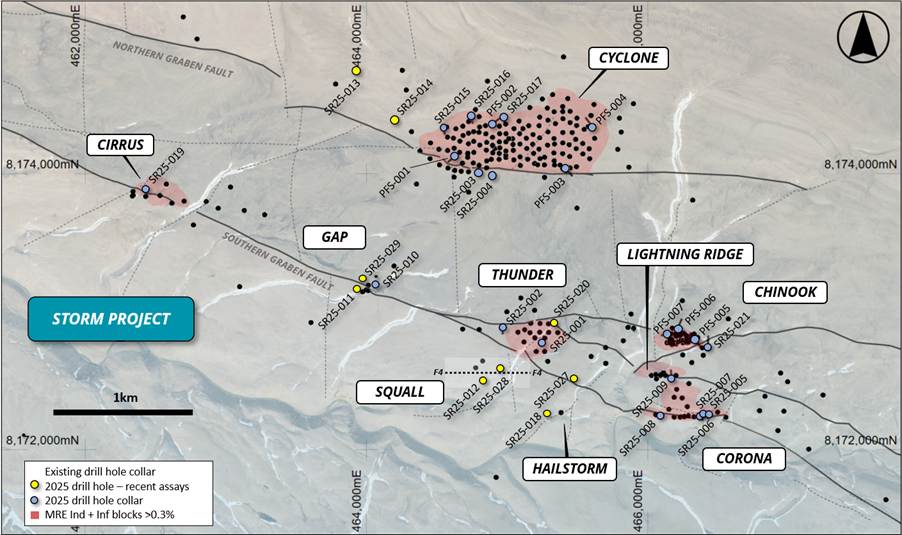
Figure 5: Drill hole location plan of the Storm area showing drilling, known copper deposits, and structural features, overlaying aerial topography.
Squall/Hailstorm
Drill hole SR25-012 was drilled at the Squall prospect to follow up on drill hole SR24-108 from the 2024 drilling program. SR24-108 was drilled to test an Electro-Magnetic (EM) anomaly, and the drill hole terminated in copper mineralization at approximately 181.4m downhole (1.5m at 2.36% Cu, 5.0g/t Ag). Drill hole SR25-012 was designed to follow up on the 2024 discovery and test the true extent of the mineralized interval. The drill hole intersected 4.5m of 1.4 % Cu, 2.6g/t Ag from 158.5m downhole (Figure 6), including 1.5m of 3.5% Cu, 5.0 g/t Ag from 158.5m downhole.
Drill hole SR24-135 is located approximately 60m to the west of Squall and also intersected copper mineralization within the same stratigraphic horizon (1.5m @ 0.5% Cu, 3.0g/t Ag from 163.07m downhole).
Observations from the three drill holes in the Squall area indicate that the stratigraphy is relatively flat-lying, with the mineralization style and thicknesses similar to those of the Corona Deposit, located approximately 1.3km to the southeast. It is interpreted that Squall may represent a faulted, dropped-down extension to the Corona Deposit, and the area in between remains a high priority for further resource definition.
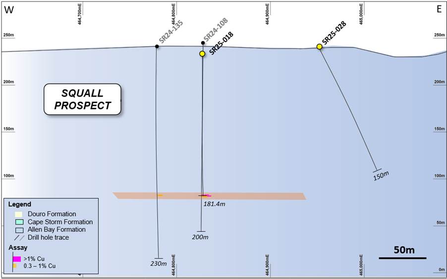
Figure 6: Drill hole long-section of the Squall area (+/- 75m window along 8,172,575N).
The Gap
Drill holes SR25-011 and SR25-029 were aimed at extending the known mineralization at The Gap prospect, where previous drilling had intersected (8m @ 5.3% Cu in drill hole SR24-03).
Drill hole SR25-029 was completed along strike to the west of the known mineralization and intersected 3m @ 0.8%, 1.5g/t Ag Cu from 76.2m.
Broad intervals of anomalous copper were intersected within SR25-011, with no high-grade intervals.
Mineralization remains open at the Gap prospect, both East and West along the Southern Graben Fault, which is the interpreted host of the high-grade mineralization. Further work will involve drilling along the Southern Graben Fault.
Cyclone North West
Drill holes SR25-013 and SR25-014 were completed to the far west of Cyclone and were designed to test conceptual targets and gather stratigraphic information. These drill holes did not encounter any significant copper sulphide mineralization.
TORNADO REVERSE CIRCULATION EXPLORATION DRILLING
The Tornado Graben is interpreted to be a direct analogue to the Central Graben at Storm, which hosts the known copper deposits at the project. Its location, approximately 5km along strike from Storm, large copper in soil anomalies, and identical structural features rank the area highly and are a likely continuation of Storm. Exploration at Tornado during 2025 consisted of five reverse circulation drill holes with the aim of testing below known fault-hosted, surficial copper occurrences and delineating the stratigraphy of the area.
Drill hole SR25-026 was completed at the western end of the Tornado Graben area and to a depth of 199.64m (Figures 7 and 8). The drill hole was planned as a stratigraphic hole that also aimed to test a broad Mobile Magneto-Telluric (MMT) target identified earlier in the 2025 season.
Three distinct, copper-silver mineralized horizons were intersected within SR25-026, including 1.5m @ 0.11% Cu, 3.0g/t Ag from 83.8m, 1.5m @ 0.13% Cu, 1.0g/t Ag from 147.8m, and 1.5m @ 0.13% Cu, 3.0g/t Ag from 167.6m downhole. All copper sulphides were hosted within the Allen Bay Formation and are interpreted to be stratabound. However, it is inconclusive whether the intersections in SR25-026 are related to the MMT anomaly.
The Allen Bay Formation was intercepted at a relatively shallow depth of 112m downhole, making it amenable for further exploration using an RC drill rig in the vicinity of SR25-026.
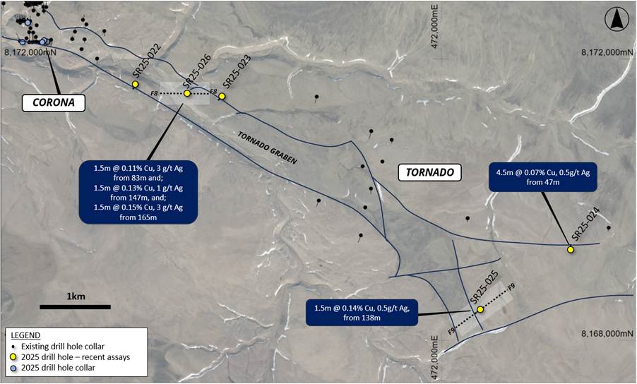
Figure 7: Drill hole location plan of the Tornado area showing drilling, known copper deposits, and structural features, overlaying aerial topography.
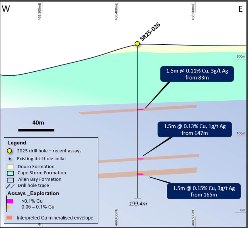
Figure 8: Drill hole section of SR25-026 in the Tornado area.
SR25-025 was designed to follow up on a series of fault-related copper gossans in the far east of the Tornado Prospect. The area was a conceptual target based on the recent field mapping and rock chip sampling.
The drill hole was drilled to a depth of 200m (Figure 9), and it is interpreted to have intercepted the targeted fault and minor copper mineralization at a depth of 71m. The drill hole is interpreted to have intersected the faulted contact between the Cape Storm and the prospective Allen Bay Formation, confirming the potential for further occurrences of copper mineralization on the south-west side of the fault (Figure 7).
The recent drill holes in the Tornado area have built on the geological model and confirmed the highly prospective nature of the area. The large volume of copper at the surface and confirmation of fault-hosted copper sulphide mineralization suggest that the structures may be the plumbing system with the potential to develop a large sediment-hosted copper system at depth. Future diamond drilling will be planned to test these targets.
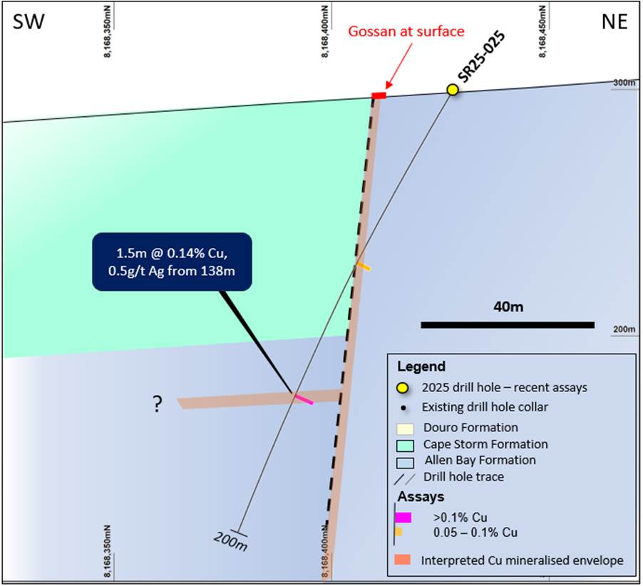
Figure 9: Drill hole section of SR25-025 in the Tornado area.
FORWARD PROGRAM
Detailed work continues on a range of Pre-Feasibility Study (PFS) activities, including metallurgy and process optimization, geotechnical assessment, waste rock and ore geochemical studies, OPEX and CAPEX review, infrastructure, and logistics review.
Work on the updated Mineral Resource Estimation (MRE) for the Storm Project is ongoing.
The environmental reporting is underway for the 2025 field season activities, which include Project-wide flora and fauna surveys, marine studies, water balance and quality studies, fish habitat studies, and geochemical assessment. This work will be combined into the Storm Copper Project Environmental Assessment (EA).
Permitting activities are continuing.
Hole ID | Prospect | From | To | Interval | Cu % | Ag g/t | Zn g/t |
SR25-011 | Gap | 51.8 | 53.3 | 1.5 | 0.13 | 1.0 | 10 |
| | 57.9 | 61.0 | 3.0 | 0.17 | 1.0 | 10 |
| | 67.1 | 70.1 | 3.0 | 0.28 | 27.5 | 15 |
| | 102.1 | 105.2 | 3.0 | 0.17 | 0.8 | 110 |
SR25-012 | Squall | 70.1 | 73.2 | 3.0 | 0.12 | 1.0 | 10 |
| | 76.2 | 77.7 | 1.5 | 0.11 | 0.5 | 100 |
| | 158.5 | 163.1 | 4.6 | 1.36 | 2.7 | 23 |
Incl. | | 158.5 | 160.0 | 1.5 | 3.55 | 5.0 | 50 |
SR25-013 | Tornado | | | | NSI | | |
SR25-014 | Tornado | | | | NSI | | |
SR25-018 | Hailstorm | | | | NSI | | |
SR25-022 | Tornado | | | | NSI | | |
SR25-023 | Tornado | | | | NSI | | |
SR25-024 | Tornado | | | | NSI | | |
SR25-025 | Tornado | 138.7 | 140.2 | 1.5 | 0.14 | 0.5 | 40 |
SR25-026 | Tornado | 83.8 | 85.3 | 1.5 | 0.12 | 3.0 | 40 |
| | 147.8 | 149.4 | 1.5 | 0.13 | 1.0 | 30 |
| | 167.6 | 169.2 | 1.5 | 0.13 | 3.0 | 20 |
SR25-027 | Thunder South | 161.5 | 163.1 | 1.5 | 0.13 | 1.0 | 10 |
SR25-028 | Squall | | | | NSI | | |
SR25-029 | Gap | 50.3 | 51.8 | 1.5 | 0.12 | 7.0 | 10 |
| | 57.9 | 59.4 | 1.5 | 0.22 | 1.0 | 10 |
| | 76.2 | 79.2 | 3.0 | 0.79 | 1.5 | 10 |
| | 96.0 | 97.5 | 1.5 | 0.12 | 1.0 | 10 |
Table 1:Summary of 2025 significant drilling intersections using a 0.1% Cu exploration cut-off grade. The intersections are expressed as downhole widths and are interpreted to be close to true widths. NSI denotes no significant intercept.
Hole ID | Prospect | Easting | Northing | RL | Depth (m) | Azimuth | Dip | Comments |
SR25-001 | Thunder | 465245 | 8172771 | 242 | 165 | 182 | -88 | Resource upgrade |
SR25-002 | Thunder | 464970 | 8172881 | 250 | 125 | 181 | -63 | Resource upgrade |
SR25-003 | Cyclone | 464800 | 8173996 | 291 | 150 | 360 | -75 | Exploration |
SR25-004 | Cyclone | 464900 | 8173977 | 290 | 150 | 360 | -75 | Exploration |
SR25-005 | Corona | 466390 | 8172256 | 235 | 90 | 178 | -56 | Resource upgrade |
SR25-006 | Corona | 466430 | 8172256 | 232 | 90 | 184 | -65 | Resource upgrade |
SR25-007 | Corona | 466370 | 8172241 | 235 | 82 | 175 | -67 | Resource upgrade |
SR25-008 | Corona | 466093 | 8172243 | 225 | 46 | 360 | -65 | Resource upgrade |
SR25-009 | Lightning | 466171 | 8172515 | 242 | 165 | 360 | -60 | Resource upgrade |
SR25-010 | Gap | 464066 | 8173192 | 238 | 150 | 191 | -50 | Exploration |
SR25-011 | Gap | 463938 | 8173162 | 237 | 150 | 170 | -50 | Exploration |
SR25-012 | Squall | 464827 | 8172501 | 233 | 200 | 360 | -65 | Exploration |
SR25-013 | Exploration | 463934 | 8174739 | 281 | 201 | 360 | -76 | Exploration |
SR25-014 | Exploration | 464205 | 8174385 | 281 | 201 | 180 | -70 | Exploration |
SR25-015 | Cyclone | 464553 | 8174330 | 292 | 201 | 180 | -70 | Resource upgrade |
SR25-016 | Cyclone | 464750 | 8174407 | 296 | 192 | 179 | -70 | Resource upgrade |
SR25-017 | Cyclone | 464981 | 8174407 | 300 | 201 | 180 | -70 | Resource upgrade |
SR25-018 | Hailstorm | 465288 | 8172259 | 222 | 168 | 135 | -55 | Exploration |
SR25-019 | Cirrus | 462432 | 8173883 | 211 | 79 | 180 | -70 | Resource upgrade |
SR25-020 | Thunder | 465335 | 8172920 | 248 | 122 | 179 | -73 | Resource upgrade |
SR25-021 | Chinook | 466430 | 8172736 | 251 | 194 | 360 | -60 | Resource upgrade |
SR25-022 | Tornado | 467696 | 8171637 | 217 | 201 | 215 | -60 | Exploration |
SR25-023 | Tornado | 468919 | 8171463 | 232 | 201 | 233 | -60 | Exploration |
SR25-024 | Tornado | 473824 | 8169283 | 331 | 165 | 360 | -60 | Exploration |
SR25-025 | Tornado | 472548 | 8168428 | 300 | 200 | 234 | -61 | Exploration |
SR25-026 | Tornado | 468424 | 8171510 | 219 | 200 | 360 | -90 | Exploration |
SR25-027 | Tornado | 465479 | 8172512 | 241 | 200 | 155 | -70 | Exploration |
SR25-028 | Squall | 464951 | 8172588 | 241 | 150 | 120 | -60 | Exploration |
SR25-029 | Gap | 463979 | 8173237 | 237 | 150 | 208 | -48 | Exploration |
ST25-01 | Cirrus | 465051 | 8174321 | 212 | 191 | 035 | -70 | To be redrilled |
ST25-02 | Cyclone S | 464948 | 8174227 | 286 | 440 | 360 | -75 | Exploration |
ST25-04 | Cirrus D. | 463035 | 8173900 | 230 | 692 | 212 | -70 | Target EM plates |
PFS-001 | Cyclone | 464629 | 8174119 | 293 | 152 | 227.18 | -65.7 | Geotech/Resource |
PFS-002 | Cyclone | 464898 | 8174357 | 299 | 176 | 50 | -60 | Geotech/Resource |
PFS-003 | Cyclone | 465422 | 8174036 | 290 | 155 | 143.11 | -61.5 | Geotech/Resource |
PFS-004 | Cyclone | 465619 | 8174327 | 293 | 212 | 319.8 | -59.8 | Geotech/Resource |
PFS-005 | Chinook | 466339 | 8172795 | 246 | 179 | 140 | -65 | Geotech/Resource |
PFS-006 | Chinook | 466138 | 8172835 | 244 | 125 | 260 | -70 | Geotech/Resource |
PFS-007 | Chinook | 466216 | 8172875 | 251 | 161 | 20 | -60 | Geotech/Resource |
Table 2: 2025 drill program details. Bold rows are results included in this announcement.
Qualified Person
Michael Dufresne, M.Sc., P.Geol., P.Geo., is a Non-Independent Qualified Person as defined by the NI 43-101 Standards of Disclosure for Mineral Projects and has reviewed and approved the scientific and technical information in this press release.
QA/QC Protocols
The analytical work reported herein was performed by ALS Global ("ALS"), Vancouver, Canada. ALS is an ISO-IEC 17025:2017 and ISO 9001:2015 accredited geoanalytical laboratory and is independent of Aston Bay Holdings Ltd., American West Metals Limited, and the QP.
Samples were subject to 33-element geochemistry by four-acid digestion and inductively coupled plasma atomic emission spectroscopy (ICP-AES) to determine concentrations of copper, silver, lead, zinc, and other elements (ALS Method ME-ICP61a).
Aston Bay Holdings Ltd. and American West Metals Limited followed industry standard procedures for the work carried out on the Storm Project, incorporating a quality assurance/quality control (QA/QC) program. Blank, duplicate, and standard samples were inserted into the sample sequence and sent to the laboratory for analysis. No significant QA/QC issues were detected during the review of the data. Aston Bay Holdings Ltd. and American West Metals Limited are not aware of any drilling, sampling, recovery, or other factors that could materially affect the accuracy or reliability of the data referred to herein.
About Aston Bay Holdings
Aston Bay is a publicly traded mineral exploration company exploring for high-grade critical and precious metal deposits in North America. The Company is exploring the Storm Copper Property and Cu-Ag-Zn-Co Epworth Property in Nunavut.
The Company and its joint venture partners, American West Metals Limited and its wholly-owned subsidiary, Tornado Metals Ltd. (collectively, "American West"), have formed a 20/80 unincorporated joint venture in respect of the Storm Project property, which hosts the Storm Copper Project and the Seal Zinc Deposit. Under the unincorporated joint venture, Aston Bay shall have a free carried interest until American West has made a decision to mine upon completion of a bankable feasibility study, meaning American West will be solely responsible for funding the joint venture until such a decision is made. After such a decision, Aston Bay will be diluted in the event it does not elect to contribute its proportionate share, and its interest in the Storm Project property will be converted into a 2% net smelter returns royalty if its interest is diluted to below 10%.
FORWARD-LOOKING STATEMENTS
Statements made in this news release, including those regarding entering into the joint venture and each party's interest in the Project pursuant to the agreement in respect of the joint venture, management objectives, forecasts, estimates, expectations, or predictions of the future may constitute "forward-looking statement", which can be identified by the use of conditional or future tenses or by the use of such verbs as "believe", "expect", "may", "will", "should", "estimate", "anticipate", "project", "plan", and words of similar import, including variations thereof and negative forms. This press release contains forward-looking statements that reflect, as of the date of this press release, Aston Bay's expectations, estimates and projections about its operations, the mining industry and the economic environment in which it operates. Statements in this press release that are not supported by historical fact are forward-looking statements, meaning they involve risk, uncertainty and other factors that could cause actual results to differ materially from those expressed or implied by such forward-looking statements. Although Aston Bay believes that the assumptions inherent in the forward-looking statements are reasonable, undue reliance should not be placed on these statements, which apply only at the time of writing of this press release. Aston Bay disclaims any intention or obligation to update or revise any forward-looking statement, whether as a result of new information, future events or otherwise, except to the extent required by securities legislation.
Neither TSX Venture Exchange nor its regulation services provider (as that term is defined in policies of the TSX Venture Exchange) accepts responsibility for the adequacy or accuracy of this news release.
For more information contact:
Thomas Ullrich, Chief Executive Officer
thomas.ullrich@astonbayholdings.com
(416) 456-3516
Sofia Harquail, IR and Corporate Development
sofia.harquail@astonbayholdings.com
(647) 821-1337
SOURCE: Aston Bay Holdings Ltd.
View the original press release on ACCESS Newswire

© 2026 Canjex Publishing Ltd. All rights reserved.