Vancouver, British Columbia--(Newsfile Corp. - November 24, 2025) - Bayridge Resources Corp. (CSE: BYRG) (OTCQB: BYRRF) (FSE: O0K0) ("Bayridge" or the "Company") is pleased to announce it has signed a Definitive Agreement to acquire a 51% interest in the Baker Lake Uranium Project (the "Project").
Highlights
The Baker Lake Uranium Project is an advanced uranium project located in the Kivalliq Region of Nunavut
located within the same Paleoproterozoic uranium district that hosts ATHA's Angilak and Orano's Kiggavik deposits
- The Project consists of 83 contiguous claims covering 619 km2
- 60 km South from the town of Baker Lake.
- $7 million in modern exploration value already completed
- Strong geological parallels to Angilak uranium camp.
- 2008 TEMPEST® survey defined 30 high-priority uranium targets
- Historical drilling returned multiple significant uranium intercepts
- 20 uranium prospects outlined along 75 km of the Baker Basin unconformity
- Unexplored high-priority drill targets remain along untested EM conductor
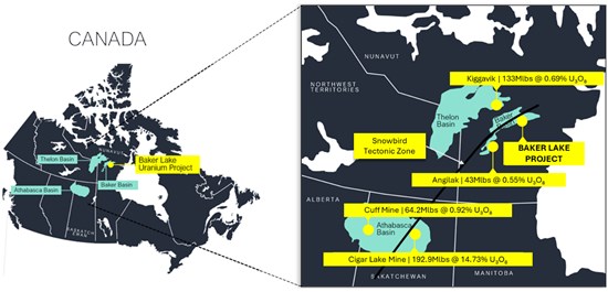
Figure 1: Baker Lake Uranium Project Location
To view an enhanced version of this graphic, please visit:
https://images.newsfilecorp.com/files/10256/275667_9dc12cb0b4272820_001full.jpg
The Project is an advanced-stage exploration opportunity supported by ~5,500 m of modern drilling, 23.5 km² of detailed surface grids, and 7,851 line-km basin-scale airborne geophysics (Figure 2). At 2025 cost equivalencies, this work represents over $7 million in exploration value (Fugro Airborne Surveys, 2008; Pacific Ridge Exploration Ltd., 2006; Pacific Ridge Exploration Ltd., 2007).
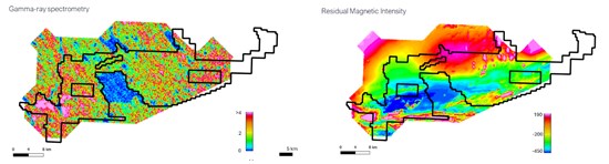
Figure 2. 2008 TEMPEST® Radiometric and EM Survey Coverage
To view an enhanced version of this graphic, please visit:
https://images.newsfilecorp.com/files/10256/275667_9dc12cb0b4272820_002full.jpg
Uranium at Baker Lake is hosted within Kazan Formation sandstones and structurally prepared corridors-features directly comparable to ATHA' and fluid pathways control high-grade mineralization (Latitude Uranium Inc. & Atha Energy Corp., 2023; Miller, 2009).
The 2008 TEMPEST® radiometric and EM survey imaged these same controls at Baker Lake, outlining steep graphitic conductors, major ENE-WSW and NNW fault corridors, a northeast structural splay, and strong uranium radiometric trends. The survey defined 30 priority targets, mapped intrusive contacts, and highlighted multiple cross-cutting structures, most of which remain untested (Figure 3) (Fugro Airborne Surveys, 2008).
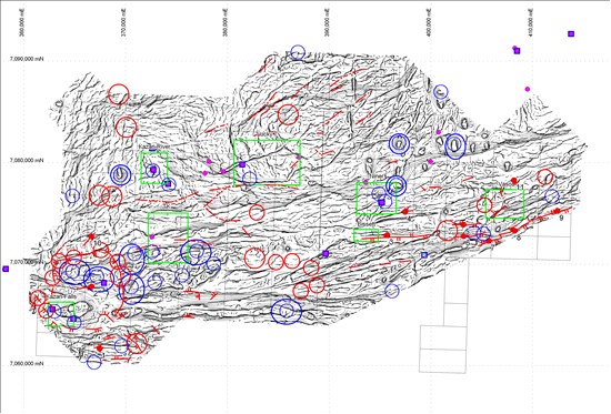
Figure 3. Interpreted 2008 TEMPEST® Structural and Conductivity Model
To view an enhanced version of this graphic, please visit:
https://images.newsfilecorp.com/files/10256/275667_9dc12cb0b4272820_003full.jpg
Exploration over the past five decades has established a robust uranium footprint in the basin. Early work by Pan Ocean (1960s-1976) and Noranda (1978-1984) identified 20 uranium prospects along 75 km of the Baker Basin unconformity. Pacific Ridge (2006-2007) advanced the project with drilling at Lucky 7, KZ, 7-One, and Niner, returning intercepts such as:
- (L7-07-07), 17.3 m of 0.30% U₃O₈
- (L7-07-10), 10.0 m of 0.35% U₃O₈
- (L7-07-06), 15.3 m of 0.20% U₃O₈ including 0.9m of 2.74% U₃O₈
- (KZ 06-02), 11.5 m of 0.31 % U₃O₈ Inc. 5.5 m of 0.56 % U₃O₈
Surface programs also outlined high-grade samples up to 1.83% U₃O₈, along with 23.5 km² of detailed radiometric and mapping grids (Figure 4) (Pacific Ridge Exploration Ltd., 2007).
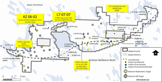
Figure 4. Property Map with 2008 Airborne Radiometric and EM Targets
To view an enhanced version of this graphic, please visit:
https://images.newsfilecorp.com/files/10256/275667_9dc12cb0b4272820_004full.jpg
Terms of the Acquisition
The Company has signed a binding Share Purchase Agreement to acquire 51% of the issued capital of 1461433 B.C. Ltd ("Privco") which is the beneficial owner of 100% of the Baker Lake Uranium Project. As consideration for the acquisition, the Company will issue 5,600,000 common shares in the capital of the Company at a deemed issuance price of $0.25 per share for total consideration of $1,400,000. Upon closing of the transaction the Company will enter into a joint venture agreement with Privco on normal industry terms and conditions with Privco having a free carried interest in the joint venture until completion of a Pre Feasability Study on the Project. The Company will have the right to appoint one director to the board of Privco (currently has one director) and Privco will be entitled to appoint one director to the board of the Company. The Company has a first right of refusal over the remaining 49% of the shares in Privco it does not own after the closing of the acquisition.
The owners of Privco will hold a 43% interest in the Company after the closing of the transaction. Completion of the transaction is subject to customary conditions including but not limited to : receipt of all required consents; and the approval of the transaction by the CSE. The Company will pay a finders fee to unrelated parties in relation to the transaction. No new control blocks will be created upon completion of the transaction.
The closing of the acquisition is subject to customary closing conditions and regulatory approvals, including approval by the Canadian Securities Exchange (CSE).
Mark Richardson P.Geo. and a Consultant and Advisor to the Company, is the Qualified Person under National Instrument 43-101 who has reviewed and approved the technical content of this release.
About Bayridge Resources Corp.
Bayridge Resources Corp. is a green energy company advancing its portfolio of Canadian uranium projects. The 1,337 ha Waterbury East project is located 25 km northeast of the Cigar Lake Mine in the northeastern Athabasca Basin region. Geophysical surveys have identified a 7km long conductivity corridor where mid-2000's drilling highlighted faulted and altered basement rock with local uranium enrichment. Large sections of this corridor remain untested.
Forward-looking information
Certain statements in this news release are forward-looking statements, which reflect the expectations of management regarding the Company's exploration plans at it's potential uranium discovery for the Company's projects. Forward-looking statements consist of statements that are not purely historical, including any statements regarding beliefs, plans, expectations or intentions regarding the future. Such statements are subject to risks and uncertainties that may cause actual results, performance or developments to differ materially from those contained in the statements. No assurance can be given that any of the events anticipated by the forward-looking statements will occur or, if they do occur, what benefits the Company will obtain from them. Except as required by the securities disclosure laws and regulations applicable to the Company, the Company undertakes no obligation to update these forward-looking statements if management's beliefs, estimates or opinions, or other factors, should change.
The CSE has not reviewed, approved, or disapproved the contents of this press release.
Appendix
Drill collar table: 2006 Pacific Ridge Drilling Campaign
| Zone | Hole ID | Northing (UTM) | Easting (UTM) | Length (m) | Azimuth (°) | Dip (°) |
| 694 Zone | 694-06-01 | 7,065,052 | 363,139 | 123.44 | 90 | -45 |
| 694 Zone | 694-06-02 | 7,065,052 | 363,138 | 136.86 | 90 | -75 |
| 694 Zone | 694-06-03 | 7,065,138 | 363,119 | 68.58 | 90 | -45 |
| 694 Zone | 694-06-04 | 7,065,138 | 363,118 | 121.31 | 90 | -70 |
| 694 Zone | 694-06-05 | 7,065,175 | 363,057 | 93.06 | 90 | -55 |
| 694 Zone Subtotal | — | — | — | 543.25 m | — | — |
| KZ Zone | KZ-06-01 | 7,079,071 | 372,753 | 148.57 | 282 | -45 |
| KZ Zone | KZ-06-02 | 7,079,071 | 372,753 | 168.25 | 282 | -70 |
| KZ Zone | KZ-06-03 | 7,079,071 | 372,754 | 55.17 | 180 | -45 |
| KZ Zone | KZ-06-04 | 7,079,065 | 372,768 | 180.87 | 287 | -70 |
| KZ Zone | KZ-06-05 | 7,079,118 | 372,767 | 179.22 | 287 | -75 |
| KZ Zone | KZ-06-06 | 7,079,069 | 372,784 | 317.14 | 282 | -80 |
| KZ Zone Subtotal | — | — | — | 1,049.22 m | — | — |
| Lucky 7 Zone | L7-06-01 | 7,078,202 | 382,264 | 85.59 | 235 | -50 |
| Lucky 7 Zone | L7-06-02 | 7,078,202 | 382,264 | 139.6 | 235 | -66 |
| Lucky 7 Zone | L7-06-03 | 7,078,202 | 382,264 | 158.19 | 235 | -80 |
| Lucky 7 Zone Subtotal | — | — | — | 383.38 m | — | — |
| Total Drilled (2006) | — | — | — | 1,969.50 m | — | — |
Source: Pacific Ridge Exploration Ltd. (2006), Baker Basin 2006 Exploration Report
Drill collar table: 2007 Pacific Ridge Drilling Campaign
| Zone | Hole ID | Northing | Easting | Depth (m) | Azimuth (°) | Dip (°) |
| Lucky 7 | L7-07-04 | 7,078,213 | 382,290 | 237.1 | 237 | -66 |
| Lucky 7 | L7-07-05 | 7,078,227 | 382,317 | 459.6 | 245 | -66 |
| Lucky 7 | L7-07-06 | 7,078,243 | 382,342 | 450.2 | 236 | -66 |
| Lucky 7 | L7-07-07 | 7,078,253 | 382,374 | 736.4 | 236 | -66 |
| Lucky 7 | L7-07-08 | 7,078,172 | 382,316 | 282.5 | 236 | -60 |
| Lucky 7 | L7-07-09 | 7,078,128 | 382,339 | 276.5 | 236 | -60 |
| Lucky 7 | L7-07-10 | 7,078,128 | 382,339 | 378.6 | 236 | -71 |
| Subtotal |
|
|
| 2,820.90 |
|
|
| KZ | KZ-07-07 | 7,079,055 | 372,817 | 306.9 | 282 | -66 |
| KZ | KZ-07-08 | 7,079,055 | 372,817 | 450.4 | 282 | -75 |
| Subtotal |
|
|
| 757.3 |
|
|
| Total |
|
|
| 3,578.20 |
|
|
Source: Pacific Ridge Exploration Ltd. (2007), Baker Basin 2006 Exploration Report
Historic Sampling, QAQC and Analytical Procedures
Pacific Ridge 2006 QA/QC and Analytical Procedures
In 2006, Pacific Ridge collected 209 surface samples and 200 drill core samples from the 694, KZ, and Lucky 7 zones. Samples were sealed, bagged, and shipped by air to Activation Laboratories (ActLabs), Ancaster, Ontario, an ISO-accredited facility. Surface samples weighed 3-5 kg; drill core was split into ~1 m intervals (~2.5 kg). QA/QC included blank Kazan arkose and quarter-core duplicates inserted at ~5% frequency. Core was scanned with an Exploranium GR-135 scintillometer prior to sampling. All samples were crushed and pulverized to -150 mesh and analyzed using Fusion XRF and Delayed Neutron Counting (DNC) for uranium, with select fire assay-AA analysis for gold. Thirteen pulp check samples (~7%) were sent to SRC for independent verification.
Source: Pacific Ridge Exploration Ltd., 2006 Exploration Report, Baker Basin Property.
Pacific Ridge 2007 QA/QC and Analytical Procedures
During the 2006-2007 work programs, 29 surface samples and 526 drill core samples were collected from the Lucky 7, Lucky 7 East, Area 8, and KZ zones. Samples were sealed, packed in rice sacks, and shipped by air to ActLabs, an ISO-registered laboratory. Core was split using a manual splitter into 0.5-1.0 m intervals. QA/QC included quarter-core duplicates inserted every ~20 samples (~4%) and blank Kazan arkose inserted every 10-20 samples (~5%). Core was scanned with an Exploranium GR-135 scintillometer prior to sampling. Samples were crushed to -150 mesh and analyzed by Fusion XRF and DNC for uranium, with select fire assay-AA for gold and silver. Thirty pulp check samples (~6%) were analyzed at SRC, returning results within ~5% of ActLabs values. All intervals represent core lengths; true widths are unknown.
Source: Pacific Ridge Exploration Ltd., 2007 Exploration Report, Baker Basin Property.
References
Latitude Uranium Inc., & Atha Energy Corp. (2023). NI 43-101 technical report on the Angilak Project, Nunavut, Canada (effective date: March 31, 2023). Prepared by: Robert Sim, P.Geo., and William Lewis, P.Geo., Micon International Limited. 293 p.
Fugro Airborne Surveys. (2008). Baker Basin airborne geophysical survey report: TEMPEST® EM, magnetics, and gamma-ray spectrometry for Aurora Energy Resources Inc. Prepared for Aurora Energy Resources Inc.
Pacific Ridge Exploration Ltd. (2007). 2006 exploration report on prospecting, radiometrics and drilling, Baker Basin property, Kivalliq Region, Nunavut (pp. 1-68). Pacific Ridge Exploration Ltd.
Pacific Ridge Exploration Ltd. (2008). 2007 Baker Basin exploration report: Drilling, prospecting, geological mapping, and radiometric surveying, Kivalliq Region, Nunavut (pp. 1-82). Pacific Ridge Exploration Ltd.
Miller, A. R. (1980). The Baker Lake Basin: Stratigraphy, structure and uranium potential of a Paleoproterozoic basin in Nunavut, Canada (Master's thesis). University of Alberta.

To view the source version of this press release, please visit https://www.newsfilecorp.com/release/275667

© 2026 Canjex Publishing Ltd. All rights reserved.