Toronto, Ontario--(Newsfile Corp. - September 9, 2026) - Canuc Resources Corporation (TSXV: CDA) (OTCQB: CNUCF) (WKN: A41V6H) ("Canuc" or the "Company") is pleased to announce the discovery of a new near-surface gold-mineralized zone – the East-West Pit Area Zone 2 ("Zone 2") – at the Company's 100% owned East Sudbury Project ("ESP") located some 20 km east of Sudbury, Ontario. Ten (10) holes drilled into the Zone 2 target area have intersected mineralized breccia, and this new zone has been traced over a strike length of approximately 170 meters.
Ten (10) holes have intersected the target zone
Highlights
New discovery: Zone 2 is a previously unrecognized, north-dipping gold-mineralized breccia zone lying immediately adjacent to the historically mined East-West Pit at the past-producing Scadding Gold Mines and has been traced over approximately 170 metres of strike to date.
Ten (10) holes intersect the zone: To date ten (10) holes drilled into Zone 2 have intersected the targeted chlorite breccia zone, over interpreted true thicknesses of 3 to 15 metres. These holes have been drilled on approximately 25 metre spacings.
Near-surface mineralization: Gold mineralization has been intersected from as shallow as 3.5 metres downhole in SM-26-151.
Supported by surface sampling: five grab samples of pit material collected in 2025 averaged 6.72 g/t Au, ranging from 0.738 to 14.3 g/t Au. Grab samples are selective by nature and may not be representative of the mineralization.
Early confirmation: SM-26-153 returned 20.0 metres grading 1.51 g/t Au, including 5.0 metres of 3.78 g/t Au; SM-26-151 returned 8.0 metres of 1.21 g/t Au, including 1.0 metre of 7.58 g/t Au; SM-26-152 returned 19.9 metres of 0.56 g/t Au, including 1.0 metre of 3.2 g/t Au; and SM-26-160 returned 4.0 metres of 1.28 g/t Au together with 1.0 metre of 4.29 g/t Au.
Full results: four of the ten holes (SM-26-155, SM-26-158, SM-26-159 and SM-26-161) returned only weakly elevated gold values, and SM-26-156 returned 14.0 metres grading 0.102 g/t Au. Readers should review Table 2 for the complete results.
Open to the North: Zone 2 has been tested to vertical depths of only 50 to 75 metres along an east-west trend and remains open to the north. Historical drilling by a previous operator intersected gold mineralization in this setting at vertical depths of approximately 85 and 110 metres. (see below; the reader is cautioned that historical results are treated as an exploration guide only)
More assays pending: four (4) additional holes have been completed at the western end of the pit area, testing mineralization interpreted to be offset along a regional-scale fault. Results are pending.
Toward a maiden resource: the Company intends to include Zone 2 in the first (maiden) mineral resource estimate for ESP, which is currently expected to be released later in 2026. (see "Forward Looking Information" below)
Internally funded: Canuc receives revenue from eight (8) producing natural gas wells at its MidTex Energy Project in West Texas and holds a 4% net smelter royalty on gold production from the Scadding Gold Tailings Project.
Readers are cautioned that mineral exploration is inherently uncertain. The Company has not established any mineral resource or mineral reserve on the ESP property, and there is no certainty that all or any part of the mineralization identified to date will be converted into a mineral resource or that any deposit will be economically viable.
ESP spans 20,078 hectares and is centered approximately 20 kilometers northeast of the Prolific Sudbury Mining District. (Figure 1 – ESP Regional Location map)
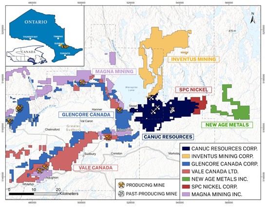
Figure 1 – ESP Regional Location Map
To view an enhanced version of this graphic, please visit:
https://images.newsfilecorp.com/files/2906/313431_e5e7bb668436a8f7_001full.jpg
ESP Fault Structures
ESP encompasses four subparallel fault structures which host historical gold and copper mines, and which are interpreted to be related to mineral systems that can form IOCG and affiliated critical and precious mineral deposits. Mineral prospective zones adjacent to these fault structures are labelled: Timmins Creek Fault Zone, McLaren Lake Fault Zone, Mount Aetna Fault Zone and Washigami Lake Fault Zone respectively (Figure 2 – ESP Fault Structures Map).
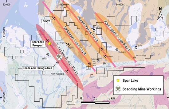
Figure 2 – ESP Fault Structures MAP
To view an enhanced version of this graphic, please visit:
https://images.newsfilecorp.com/files/2906/313431_e5e7bb668436a8f7_002full.jpg
Timmins Creek Fault Zone
Along the ESP property's furthest west fault structure, Timmins Creek Fault, are found the historical mine workings of the Scadding Gold Mines (North Pit, Underground Portal, South Pit and East-West Pit). (Figure 2 above – Scadding Mine Workings, Figure 3 below – Scadding Gold Mines and East-West Pit Area)
The Glade Area 'Exploration' Zones and the Scadding Mine Gold Tailings Impound are located approximately 1 km southwest and south of the historical Scadding Gold Mines (Figure 2 above). Other Au-Co-Cu occurrences occur along this interpreted structure (Timmins Creek Fault) including a strong breccia zone and highly anomalous Co-Au mineralization identified by Canuc in 2025 at Spar Lake (Figure 2 above), 3 km northwest of the Scadding Mine Workings.
East-West Pit Area – Historical Data and New Gold Mineralized Zone (Zone 2)
Canuc has now completed a first phase of drilling on a newly identified zone at the East-West Pit Area, now being referenced as the East-West Pit Area Zone 2 (Figures 3 and 4). Zone 2 is thought to be the down dip projection of mineralization identified by Gulf Minerals in 1973 that led to the historical gold resource estimates for the East-West Pit made by the Watt-McLean group (1979; 1981). This historical gold resource was updated and modified in 1983 for Northgate Exploration Limited (Hill, Goettler and Delaporte, 1983).
The 1983 historical estimate for the East-West Pit was 25,600 short tons grading 0.225 ounces gold per short ton (approximating to 23,224 tonnes grading 7.03 g/t Au). This estimate was classified as open pit "diluted indicated and diluted inferred reserves". The estimate applied a 1:1 waste-to-ore dilution ratio and had a cut-off grade of 0.08 oz/ton (2.74 g/t) Au. Under current definition standards and with appropriate, validated data this mineralized zone would best be considered an Inferred Mineral Resource.
Cautionary note: The historical estimate predates NI 43-101 and uses terminology that is not consistent with current CIM Definition Standards. A Qualified Person has not completed sufficient work to classify the historical estimate as a current mineral resource or mineral reserve, and the Company is not treating the historical estimate as a current mineral resource or mineral reserve. The estimate should not be relied upon as representing mineralization remaining in the ground and may have been materially depleted by historical mining. Canuc considers the historical estimate relevant only as evidence of the location and historical significance of mineralization in the East-West area and as a guide for current exploration. Verification would require reconstruction of the historical pit, confirmation of collar and survey information, direct validation of assays and density data, confirmation drilling, and modern three-dimensional geological and resource modelling.
In 1984, Westfield Minerals (Northgate subsidiary) began test-mining small open pit deposits in the Scadding Mine area while developing the main underground Scadding Mine. This included the East-West Pit where a 100 m long, 5 to 8 m deep open cut was driven into the surface exposure of a 10 m wide mineralized zone. The tonnage extracted from this pit is unknown.
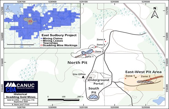
Figure 3 – Scadding Gold Mines and East-West Pit Area
To view an enhanced version of this graphic, please visit:
https://images.newsfilecorp.com/files/2906/313431_e5e7bb668436a8f7_003full.jpg
East-West Pit Area, New Mineralized Gold Zone (Zone 2)
The East-West Pit Area was re-examined by Company geologists in 2025. Five grab samples taken from material from the pit averaged 6.72 g/t Au with values ranging from 0.738 to 14.3 g/t Au. (The reader is cautioned that grab samples are selective by nature and may not be representative of the underlying mineralization or reflect the actual average grade of the mineralized zone.)
The mineralization is contained within intense, small fragment, chlorite breccia with associated sulphides. The zone appears to be developed within a brecciated quartzite unit, hosting mega scale fragments, that overlies a limestone unit dipping steeply (70 to 75 degrees) towards the north.
Ten (10) shallow holes have now been drilled to trace a structure dipping north from an area proximal to, and north northeast of, the pit. These 10 holes were drilled to a depth of approximately 35 m. All holes intersected the targeted breccia zone over true thicknesses of 3 to 15 metres with mineralization similar in appearance to that exposed in the East-West Pit. This new gold zone (East-West Pit Area Zone 2) has been traced over a strike length of approximately 170 m. The Company interprets the intersection of the zone across 10 holes drilled as evidence of a coherent, laterally continuous mineralized structure.
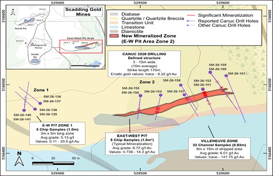
Figure 4 – East-West Pit Area (Zones 1 & 2 Drill Collar Locations)
To view an enhanced version of this graphic, please visit:
https://images.newsfilecorp.com/files/2906/313431_e5e7bb668436a8f7_004full.jpg
Current Drilling East-West Pit Area, Zone 2
Drill holes SM-26-151 through SM-26-161 (drilled July-August, 2026) were completed to test the Zone 2 target which splays from the historically mined East-West Pit. The holes ranged from 48 metres to 107 metres in length. The collar locations are shown in Table 1 – East-West Pit Area – Zone 2 Collar Information.
Table 1 – East-West Pit Area Zone 2 Collar Information
| Drill Hole | NAD 83 Zone 17N | Elevation | Azimuth | Dip | Depth |
| Easting | Northing | (m) | (ᵒ) | (ᵒ) | (m) |
| SM-26-151 | 529576 | 5166494 | 302 | 160 | -45 | 60 |
| SM-26-152 | 529576 | 5166493 | 302 | 161 | -65 | 48 |
| SM-26-153 | 529525 | 5166485 | 308 | 190 | -45 | 52 |
| SM-26-155 | 529500 | 5166484 | 308 | 186 | -47 | 51 |
| SM-26-156 | 529500 | 5166484 | 308 | 185 | -76 | 107 |
| SM-26-157 | 529553 | 5166485 | 305 | 152 | -46.7 | 51 |
| SM-26-158 | 529549 | 5166499 | 305 | 151 | -65.8 | 101 |
| SM-26-159 | 529585 | 5166518 | 300 | 149 | -43 | 87 |
| SM-26-160 | 529585 | 5166518 | 300 | 149 | -60 | 102 |
| SM-26-161 | 529604 | 5166513 | 298 | 161 | -45 | 102 |
East-West Pit Area Zone 2
The holes were drilled on approximate 25 m sections into the East-West Pit Area Zone 2 as part of the initial evaluation of this target. The intersected values are shown in Table 2 – East-West Pit Area – Zone 2 Drill Results.
Table 2 – East West Pit Area – Zone 2 Drill Results
| Drill Hole | Zone | From | To | Intersected Width
(m) | Au |
| (m) | (m) | (g/t) |
| SM-26-151 | E-W Zone 2 | 3.5 | 11.5 | 8 | 1.21 |
| Incl: | 7.5 | 8.5 | 1 | 7.58 |
| SM-26-152 | E-W Zone 2 | 7.6 | 27.5 | 19.9 | 0.56 |
| Incl: | 8.6 | 9.6 | 1 | 3.2 |
| SM-26-153 | E-W Zone 2 | 18.3 | 38.3 | 20 | 1.51 |
| Incl: | 26.3 | 31.3 | 5 | 3.78 |
| SM-26-155 | E-W Zone 2 | weakly elevated gold values |
| SM-26-156 | E-W Zone 2 | 79.5 | 93.5 | 14 | 0.102 |
| SM-26-157 | E-W Zone 2 | 9 | 14.5 | 5.5 | 0.572 |
| SM-26-158 | E-W Zone 2 | weakly elevated gold values |
| SM-26-159 | E-W Zone 2 | weakly elevated gold values |
| SM-26-160 | E-W Zone 2 | 35 | 36 | 1 | 4.29 |
| also | 50 | 54 | 4 | 1.28 |
| Incl: | 52 | 53 | 1 | 3.52 |
| SM-26-161 | E-W Zone 2 | weakly elevated gold values |
The hole locations and related sample information are shown on Figure 4 above – East-West Pit Area (Zones 1 & 2 Drill Collar Locations).
Note to Table 2: widths shown are drilled core lengths. True widths of the mineralized zone are interpreted to be in the range of 3 to 15 metres based on current geological interpretation. Holes reported as returning weakly elevated gold values did not return intervals meeting the grade and width criteria applied to the intersections reported above.
Ten (10) Holes Confirm the New Gold Zone Over 170 Metres of Strike Extent
Ten (10) holes have been drilled to test the zone along strike and at depths of 50 to 75 m. To date this new zone (East-West Pit Area Zone 2) has been defined for a strike length of approximately 170 m. It appears to pinch out to the east and may be offset towards the northwest on the western end of the pit.
The zone is thought to have been intersected by a previous explorer (Trueclaim Exploration Inc.) who intersected a gold zone with 2 lenses of mineralization at vertical depths of 85 and 110 m before entering the underlying limestone unit. The upper intersection of 5.77 m (98 – 103.77 m) assayed 3.95 g/ t Au including 2 m at 7.83 g/t Au; the lower intersection was 10.25 m of 1.38 g/t Au including 0.7 m of 8.2 g/t Au (Trueclaim Assessment Report, 2011). The hole was drilled down dip, so the true thickness of the zone is unknown. (The drill results reported above are historical in nature and are being treated as an exploration guide only.)
Further to these 10 holes, four (4) additional holes have been completed in the western end of the pit area to test mineralization that appears to be offset along an interpreted, regional scale fault system that passes through this area. Complete analytical results from these holes will be reported as soon as assay certificates have been received, the results have passed the Company's QA/QC review, and the technical disclosure has been reviewed by the Company's Qualified Person.
Management Commentary – Advancing Toward a Maiden Mineral Resource Estimate
"These results provide early confirmation for the discovery of a new, north dipping, gold zone (East-West Pit Area Zone 2) in the East-West Pit Area of the historical Scadding Gold Mines," stated Christopher Berlet, President and CEO of Canuc.
"The most significant finding from this work is that the newly identified gold zone appears to be continuous over a considerable strike extent, representing a greater dimension than previously identified for structures at the Scadding Gold Mines. Despite a drilling history involving a number of companies dating back to at least the mid 1970's, Zone 2 sat undetected beside old mine workings in the East-West Pit Area for a period spanning several decades providing support for our thesis that the project area is host to significant unrecognized potential."
"Our revised plan is to continue drilling this newly identified gold zone for as long as we are able to track it, and our objective is now to include this new zone in the ESP property's maiden mineral resource estimate, which we currently expect to release later this year. With four additional holes in the lab and the zone still open to the north, we expect to be able to provide a steady flow of news through the balance of 2026."
Sampling and Quality Assurance / Quality Control
All core samples were logged and split in half using a diamond saw at the Company's secure core logging facility. Split cores were then securely transported directly to the Activation Laboratory preparation laboratory in North Bay, ON and subsequently assayed for Au and multi-element ICP analysis in Actlabs' ISO accredited laboratory in Ancaster, ON. Blind control samples (1 standard, 1 duplicate and 1 blank in each 30 samples submitted) were routinely inserted into the sample stream before shipping. Data verification was completed successfully.
The technical information in this release has been reviewed and approved by Seymour Sears, B.A., B.Sc., P.Geo, a non-independent qualified person as defined by NI 43-101, who is currently managing exploration activity on the ESP Project.
About Canuc Resources Corporation
Canuc Resources Corporation is a junior resource company developing its 100% interest in the East Sudbury Project ("ESP") which spans 20,078 hectares and is centered approximately 20 kilometers northeast of the Prolific Sudbury Mining Camp and near to the extensive infrastructure of the adjacent Sudbury Mining District. ESP encompasses several centers of critical and precious metal mineralization interpreted to be related to a mineral system that can form IOCG and affiliated critical and precious mineral deposits. Included within the Project is the historical Scadding Gold Mine and associated Scadding Gold Tailings Project.
Canuc also holds a 100% interest in the San Javier Silver-Gold Project located in Sonora State, Mexico. The San Javier Silver-Gold Project spans 28 claims covering 1,052 hectares and evidences extensive silver, gold and copper mineralization interpreted to be related to a mineral system that can form silver-dominant IOCG and affiliated deposits.
Canuc generates cash flow from natural gas production at its MidTex Energy Project located in Central West Texas, USA where Canuc has an interest in eight (8) producing natural gas wells and has rights for further in field developments. The Company also receives a 4% Net Smelter Royalty from gold production at the Scadding Gold Tailings Project located on Mining Claim LEA 107735 within the ESP property group.
For further information please refer to the Company website: www.canucresources.ca
Christopher J. Berlet B.A.Sc.(Mining), CFA, CEO & Director of Canuc, is responsible for the content of this press release.
Forward-Looking Information
This news release contains forward-looking information. All information, other than information of historical fact, constitute "forward-looking statements" and includes any information that addresses activities, events or developments that the Corporation believes, expects or anticipates will or may occur in the future including the Corporation's strategy, plans or future financial or operating performance.
When used in this news release, the words "estimate", "project", "anticipate", "expect", "intend", "believe", "hope", "may" and similar expressions, as well as "will", "shall" and other indications of future tense, are intended to identify forward-looking information. The forward-looking information is based on current expectations and applies only as of the date on which they were made. The factors that could cause actual results to differ materially from those indicated in such forward-looking information include, but are not limited to, the ability of the Corporation to fund the exploration expenditures required under the Agreement. Other factors such as uncertainties regarding government regulations could also affect the results. Other risks may be set out in the Corporation's annual financial statements, MD&A and other publicly filed documents.
The Corporation cautions that there can be no assurance that forward-looking information will prove to be accurate, as actual results and future events could differ materially from those anticipated in such information. Accordingly, investors should not place undue reliance on forward-looking information. Except as required by law, the Corporation does not assume any obligation to release publicly any revisions to forward-looking information contained in this press release to reflect events or circumstances after the date hereof.
Neither the TSXV nor its Regulation Services Provider (as that term is defined in the policies of the TSXV) accepts responsibility for the adequacy or accuracy of this news release.

To view the source version of this press release, please visit https://www.newsfilecorp.com/release/313431

© 2026 Canjex Publishing Ltd. All rights reserved.