VANCOUVER, BC / ACCESS Newswire / August 10, 2026 / Gemdale Gold Inc. (TSXV:GEMG)(OTCQB:GDGIF) ("Gemdale" or the "Company") is pleased to announce further drill results from the 2026 drill program at its 100% owned Pontio Gold Project located in western-central Finland. This release reports on the results of 9 holes from the southern (S1 and S2) Sectors of the M2 Trend at Pontio, focussed mainly on the S1 Sector, as part of the 5,009m, 28 diamond drill hole 2026 Phase 1 programme.
Highlights
Intersections from the S1 Sector continue to show wide zones of near surface, bulk tonnage style gold mineralisation, with higher-grade intervals (downhole) as follows:
HOLE PONT091 indicates the possible continuity of mineralisation southwards from Sector S1 through to Sector S2 and infills a gap in drilling of 600m between Sectors S1 and S2, intersecting:
Overall, the results significantly extend the width of the S1 Sector of the M2 Trend. The mineralised diorite porphyry, host to the subcropping gold mineralisation, is now more than 140m in estimated true width on some profiles.
The deposit remains completely open at depth with an average drill depth of less than 100m to date along the 4km of mineralised strike extent.
Toby Strauss, President and CEO comments "We are delighted with this next set of results, from the southern Sectors of the M2 Trend at Pontio. PONT093 returned our best ever intersection in terms of length and grade, including a section of much higher grade mineralisation at grades rarely observed to date at Pontio. These results not only can lift the average grade, but have also substantially increased the thickness of the mineralised porphyry body in the S1 Sector. While we still have a few drill results remaining to report from our H1 2026 program, we also now look forward to the H2 program, starting later in August, which will include further testing in the newly recognised area of the known higher grades as well as continuing to tighten the infill drilling in advance of a maiden Resource Estimate anticipated in early 2027."
Details of the Drilling
The drill results being reported in this press release are all from the southern (S1 and S2) portions of the M2 Trend (Figure 1), which occur over a known strike length of approximately 1.7km. The hosts to mineralisation in the S1 and S2 Sectors are predominantly dioritic porphyries, as opposed to the northern areas of the M2 Trend where the host rocks are predominantly older equigranular diorite dykes. Both the diorites and the dioritic porphyries are mineralised.
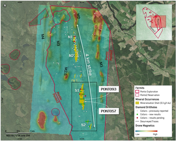 Figure 1 Plan view of the Pontio deposit, showing the location of the recent drilling.
Mineralisation in the Southern Sectors of the M2 Trend
PONT085 was drilled on a profile at the northern end of the S1 Sector (Figure 2). The hole was drilled eastwards into the main body of the S1 porphyry as a scissor hole to holes BELANP024 and PONT023, both of which intersected shallow mineralisation, but due to their short lengths had failed to delineate the western margin of the porphyry body on this profile. PONT085 intersected a number of mineralised zones throughout the length of the drillhole (206.6m). These intersects are summarised in Table 1, but cumulatively the mineralised zones in the porphyry approximate 98m of downhole intersects. This profile (including the previous holes) now has a true thickness of over 120 m.
PONT086 was drilled westwards on a profile 100m south of PONT085, infilling a 200m gap between profiles. PONT086 intersected numerous mineralised zones (Table 1) with cumulative downhole thicknesses of 132m. A scissor hole (PONT096) was also drilled on this profile and the results remain pending. The true thickness of the porphyry intrusion on this profile is in excess of 150m.
PONT087 and PONT093 infilled a 200m gap in the profiles in the central portion of the S1 Sector. Both holes intersected good thicknesses of mineralised porphyry (see Table 1) with PONT087 intersecting 48.89m @ 0.68 g/t Au from 24.70m downhole. PONT093 returned the single best intersection from Pontio to date with 110.00m @ 1.18 g/t Au from 99.08m downhole. This included 3 contiguous samples each over 10 g/t Au, which composited at 5.19m @14.01 g/t Au from 137.90m. This high grade area confirms the observation of visible gold previously reported (see news release dated 28th July, 2026), and is approximately 100m north of the other occurrence of visible gold observed in PONT057 (which included 17.93m at 2.83 g/t Au including 0.97m at 31.1 g/t Au). There is now the intriguing possibility that this area represents a higher grade portion of the mineralisation, which will need to be tested by drilling. A shallower zone was also intersected in PONT093, which takes the true thickness of the mineralised porphyry on this profile to over 145m.
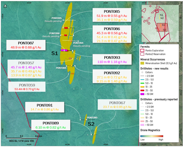 Figure 2 Plan of the S1 and S2 Sectors of the M2 Trend mineralisation at Pontio. Grade thickness (GT) is calculated as gold grade (g/t) x interval thickness (m) and is reported as gram metres (GM).
PONT088 and PONT092 were drilled on a profile 100m south of PONT057 into a narrow portion at the southern end of the S1 porphyry, infilling a gap of 200m between profiles. PONT088 was drilled to test for further porphyries to the west but failed to intersect any porphyry. PONT092 intersected 27.09m @ 0.72 g/t Au from 48.80m plus 9.15m @ 1.46 g/t Au from 92.07m downhole.
Prior to this phase of drilling the southernmost drillhole to intersect the S1 sector mineralisation was PONT059, with an 800m gap southwards to PONT067 and the intersection of the S2 Sector. PONT062 (200m south from PONT059) had intersected weakly mineralised porphyry, although it is unclear if this is the main M2 Trend porphyry. Three holes in this recent phase of drilling were drilled south of S1 (PONT090 and PONT091) and down into S2 (PONT089).
PONT090 and PONT091 were drilled on a profile 200m north of the PONT067 profile. PONT091 intersected 14.73m @ 0.86 g/t Au from 86.43m downhole. This confirms that the gap between S1 and S2 Sectors does contain mineralised porphyry and thus has the potential to host further mineralisation, that potentially connects the two sectors.
PONT089 was drilled beneath PONT067, and intersected 6.10m @ 0.82 g/t Au in mineralised diorite (as opposed to porphyry in PONT067). Further drilling with a scissor hole is needed in this profile to better understand the geology and mineralisation. No holes exist to the south of this profile for 600m, so mineralisation remains open along strike to the south, and this is also a target for future drilling.
The S1 Sector now has a total 19 drillholes along approximately 100m spaced profiles, with most profiles having 2 - 4 drillholes. Not all results from the S1 Sector have been received. The significant intersections from the southern Sectors are shown in Table 1.
Hole | From (m) | To (m) | Length (m) | Au g/t |
PONT085* | 27.49 | 79.44 | 51.95 | 0.55 |
including | 50.02 | 54.06 | 4.04 | 1.53 |
PONT085* | 85.32 | 120.40 | 35.08 | 0.59 |
including | 90.58 | 99.94 | 9.36 | 1.18 |
PONT085* | 183.29 | 194.58 | 11.29 | 0.48 |
PONT086* | 19.43 | 20.63 | 1.20 | 4.77 |
PONT086* | 45.19 | 58.69 | 13.50 | 0.57 |
PONT086* | 89.55 | 110.94 | 21.39 | 0.47 |
PONT086* | 120.31 | 165.62 | 45.31 | 0.56 |
including | 142.01 | 145.15 | 3.14 | 1.83 |
PONT086* | 173.91 | 225.32 | 51.41 | 0.41 |
PONT087* | 24.70 | 73.59 | 48.89 | 0.68 |
including | 70.21 | 72.40 | 2.19 | 2.81 |
PONT089* | 29.61 | 35.71 | 6.10 | 0.82 |
PONT091* | 86.43 | 101.16 | 14.73 | 0.86 |
including | 92.41 | 94.38 | 1.97 | 3.61 |
PONT092* | 48.80 | 75.89 | 27.09 | 0.72 |
including | 57.10 | 63.16 | 6.06 | 1.30 |
PONT092* | 92.07 | 101.22 | 9.15 | 1.46 |
including | 97.11 | 101.22 | 4.11 | 2.52 |
PONT093* | 81.94 | 91.04 | 9.10 | 0.93 |
PONT093* | 99.08 | 209.08 | 110.00 | 1.18 |
including | 137.90 | 143.09 | 5.19 | 14.01 |
BELANP024 | 17.37 | 98.26 | 80.89 | 0.48 |
PONT020 | 9.95 | 45.65 | 35.70 | 0.47 |
PONT021 | 10.12 | 38.10 | 27.98 | 0.65 |
PONT022 | 42.40 | 83.25 | 40.85 | 0.68 |
including | 77.81 | 82.11 | 4.30 | 2.83 |
PONT023 | 5.60 | 39.65 | 34.05 | 0.50 |
PONT023 | 53.68 | 73.00 | 19.32 | 0.64 |
PONT057 | 5.40 | 19.30 | 13.90 | 0.87 |
including | 7.52 | 9.70 | 2.18 | 2.79 |
PONT057 | 25.61 | 71.28 | 45.67 | 1.40 |
including | 39.60 | 57.53 | 17.93 | 2.83 |
PONT057 | 76.19 | 111.93 | 35.74 | 0.49 |
PONT059 | 44.52 | 97.91 | 53.39 | 0.70 |
including | 47.68 | 52.03 | 4.35 | 1.22 |
including | 63.42 | 65.69 | 2.27 | 3.32 |
PONT067 | 7.50 | 31.16 | 23.66 | 0.95 |
including | 8.30 | 25.21 | 16.91 | 1.17 |
Table 1 Significant drill intersections from the southern Sectors of the M2 Trend. Intersection lengths are downhole lengths, Bulk intersections are reported at a cutoff grade of 0.3 g/t gold with 10m internal dilution. True widths are estimated as 65-85% of downhole intersect length. Drillhole locations listed in Appendix. Holes not included in Table 1 intersected no significant gold mineralisation greater than the cutoff or a grade thickness greater than 5. Newly reported drillholes marked with an asterisk.
Discussion on Results
The S1 Sector has now largely been drilled on 100m profiles (Figure 3), and the drilling has been successful in extending and widening the mineralisation in the S1 Sector, as well as potentially raising the average grade of this part of the deposit, bringing it in line with bulk grades seen in the N1 and N2 Sectors of the M2 Trend. The S1 Sector has been considerably widened by this phase of drilling (with 3 holes remaining to receive results), with true thicknesses of mineralised porphyry now well into the 120 - 150m range.
The extension of the mineralisation south of the S1 Sector is also very interesting, and although drilling in this area remains sparse, the results continue to support the idea that further mineralisation may be found in this 800m gap between S1 and S2 Sectors. Furthermore, the additional intersection in the S2 Sector suggests that mineralisation continues, with the southward strike extension remaining open.
All drilling in the southern Sectors, as with the N1 and N2 Sectors, remains relatively shallow and, given the general steep dipping nature of the host rocks, mineralisation remains open to depth.
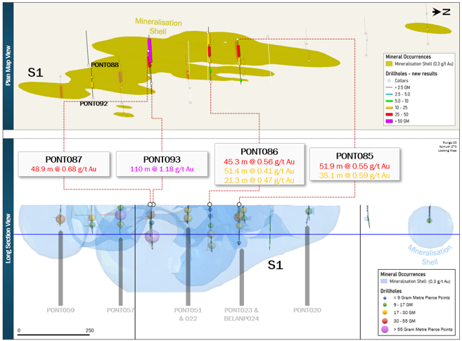 Figure 3 Long Section of southern (S1 and S2) Sectors showing the 0.3 g/t Au mineralisation shell and the pierce points of the drillhole intercepts which are colored and sized according to grade*thickness in gram metres
About Pontio
The Pontio Gold Project lies in western-central Finland, in an historical mining district featuring extremely good infrastructure, including paved roads, power and rail lines within a few kilometres. A highly skilled labour force and a high level of local services are available, including port access, smelters and refineries. Despite a long history of base metals mining gold exploration in the area is still in its infancy; Pontio was only discovered in 2011 when the area's first gold mine (Laiva, some 45 km to the NW) was being commissioned.
Gold mineralisation has so far been outlined by drilling over a 4km strike length along the M2 Trend (Figure 1); mineralisation subcrops just beneath the surface, covered by a thin layer of soil, sand and gravel, and extends to at least 150m vertical and ranges from 20->150m in estimated true thickness. Gold mineralisation is mainly hosted in subvertical diorite and diorite porphyry dykes intruding gneissic metasediments that occur along a NNW trending mineralised corridor.
The M2 Trend is one of a number of identified potential gold bearing structures with the others, such as the M1, M2.5 and M3 Trends yet to have significant exploration along their lengths. The M2 Trend mineralisation can be subdivided into several zones or Sectors labelled N1, N2, S1 and S2.
Gold mineralisation is typically fine-grained and associated with disseminated chalcopyrite and pyrrhotite in generally weakly sheared and variably potassic altered intrusive rocks. Alteration is in the form of biotite amphibole and potassium felspar. Unusually for the area there is no particular association with quartz veining and arsenopyrite mineralisation. Rarely, molybdenum is noted with quartz veining. Mineralisation postdates peak metamorphism and is intimately associated with the late intrusive diorite porphyries which are younger than the diorite dykes. The deposit is enigmatic in style but has affinities with the roots of a deep level porphyry system or a disseminated orogenic style of gold mineralisation.
Drilling, Core Sampling and QA/QC Protocols
The drill programme was contracted to Nivalan Timantikairaus Oy ("NTKOY"). Drilling was completed with an Atlas Copco CS1000 rig drilling HQ3 sized core. The drill programme started in January 2026 and was completed in May 2026.
Drill core is logged and sampled in a secure core storage facility located in Ylivieska, Finland. Core samples from the program are cut in half, using a diamond cutting saw, and are sent to ALS Minerals, Outokumpu, an international accredited mineral analysis laboratory, for sample prep and analysis. All samples are analysed for gold using Fire Assay-AA techniques (method Au-AA23) and multi-element analysis (method ME-MS61). As part of Gemdale's quality assurance/quality control program (QA/QC), certified gold reference standards are routinely inserted into the sample stream every 20th sample (5%). The Qualified Person has reviewed the results of the QA/QC programme and confirms that no significant QAQC issues were noted with the results reported herein.
Qualified Person and NI 43-101 Disclosure
Dr. Toby Strauss (CGeol.; EurGeol.), Director, President and CEO of the Company, is the Qualified Person as defined by National Instrument 43-101. Dr Strauss has verified the data supporting this news release. Verification includes checking the reported assays in the Company database against the issued laboratory assay certificates. Additional verification has included checking the location and orientation of the drill collars in the Company database against historic maps and reports. Dr Strauss is responsible for the accuracy of technical information contained in this news release. Dr Strauss has reviewed and approved the technical and scientific content of this news release.
More About Gemdale Gold
Gemdale Gold Inc. owns a portfolio of highly prospective exploration licenses in Finland, and is focused on making significant new gold and critical metal discoveries on these properties. The Company has been active in Finland since 2018. The Company's 100% owned projects include:
Pontio Gold Project (western-central Finland): Historical and recent drilling has outlined near-surface gold mineralisation along a multi-kilometre trend that remains open along strike and at depth. The Company started an infill and extension drill programme in February, 2026, and, based on this programme, plans to deliver a maiden mineral resource estimate in early 2027.
Isoneva (western-central Finland): Exploration stage gold project located proximal to extensive boulder train anomalies. The property is subject to an option agreement (the "Isoneva Option") with Nordique Resources Inc. ("Nordique") pursuant to which Nordique may earn a 100% interest by, among other things, funding exploration expenditures over a three-year period and making additional financial commitments to the Company. For more information on the Isoneva Option, please see the Company's final long form prospectus dated January 30, 2026 under the heading "Business of the Corporation - January 1, 2025 to the date hereof".
Lapland Projects (northern Finland): A group of exploration permits and applications located within a recognised gold and base-metal exploration region, in proximity to several recent regional discoveries, including Rupert Resources' Ikkari gold project.
Nuotti (western-central Finland): Copper-nickel-platinum-palladium exploration license where limited historical government drilling indicates the presence of near-surface copper-PGM mineralisation.
Savo / Rantasalmi (southeastern Finland): Exploration license application area containing a historical NI 43-101 Inferred resource estimate prepared by a prior operator of 3.23 million tonnes grading 2.7 g/t gold for approximately 276,000 ounces of gold.
In November 2018, Rupert Resources Ltd, released an NI 43-101 Mineral Resource Estimate completed by Brian Wolfe (Qualified Person) of International Resource Solution Pty Ltd. The NI 43-101 Technical Report was filed by Rupert Resources Ltd on SEDAR on 9th November, 2018. No new data subsequent to an earlier 2011 estimate was included in this study. This study used Multiple Indicator Kriging (MIK) for the estimation of grade into the block model. This study assumed a combined open pit and underground mining operation, recoveries of 85-90% and a gold price of EUR 1,200/oz (current gold price ~ EUR 4240/oz). The use of MIK as an estimation method, along with the requirements of a greater degree of confidence in the geological continuity for underground mining, were given as the reasons for the assigned lower resource category of Inferred Resources compared to the 2011 Resource Estimate. The Resource Estimate was reported at a cut-off grade of 1.5 g/t Au.
Osikonmäki Mineral Resource Estimate for Rupert Resources Ltd, 9 Nov 2018 |
Year | Cut-off Au g/t | Classification | Tonnes | Au (g/t) | Au oz |
2018 | 1.5 | Inferred | 3,230,000 | 2.7 | 276,000 |
The Company is not aware of any further drilling or sampling being conducted on the property since this historical estimate was completed. Gemdale Gold Inc is not treating this historical estimate as a current resource estimate. Neither Gemdale Gold Inc nor a suitable Qualified Person, has done sufficient work to classify the historical estimate as a current Mineral Resource Estimate. The company believes this historical estimate is relevant and reliable in providing insight into the potential mineral resources for the project based on historical drilling completed to date, as it was completed by a Qualified Person in accordance with NI 43-101. Gemdale Gold believes that further drilling is not required to verify or upgrade these historical resources to a current Mineral Resource Estimate, but that it is necessary for a Qualified Person to review the assumptions and methodology used for the estimation.
Additional disclosure, including the Company's financial statements, technical reports, news releases and other information, can be obtained at https://gemdalegold.com/ or on SEDAR+ at https://www.sedarplus.ca/home/#.
ON BEHALF OF GEMDALE GOLD INC
"Dr. Toby Strauss"
President & CEO
For Further Information Please Contact:
Website: www.gemdalegold.com
Cautionary Note on Forward-Looking Statements
Neither the TSX Venture Exchange nor its Regulation Services Provider (as that term is defined in the policies of the TSX Venture Exchange) accepts responsibility for the adequacy or accuracy of this release.
This news release contains certain "forward-looking statements" and "forward-looking information" within the meaning of applicable Canadian securities legislation (collectively, "forward-looking information"). Forward-looking information includes, but is not limited to, statements regarding the Company's exploration and development plans, in particular the ongoing drill program on the Pontio Gold Project, other anticipated drill programs, potential mineralisation, resource estimates, future financing plans, use of proceeds, regulatory approvals, market conditions and the Company's future business objectives. Forward-looking information is generally identified by the use of words such as "plans," "expects," "is expected," "budget," "scheduled," "estimates," "forecasts," "intends," "anticipates," "believes," or variations of such words and phrases, or statements that certain actions, events or results "may," "could," "would," "might" or "will" occur or be achieved.
Forward-looking information is based on a number of assumptions that management believes to be reasonable at the time such statements are made, including, without limitation, assumptions regarding the availability of capital, the receipt of required regulatory approvals, the continuation of favourable market conditions, the accuracy of historical and technical data, and the Company's ability to execute its exploration and development plans as currently contemplated. However, forward looking information is subject to known and unknown risks, uncertainties and other factors that may cause actual results, level of activity, performance or achievements of the Company to differ materially from those expressed or implied by such forward-looking information. Such factors include, without limitation, risks related to exploration and development activities, commodity price fluctuations, availability of financing, regulatory approvals, environmental and permitting risks, operational risks, and general economic and market conditions.
Accordingly, readers should not place undue reliance on forward-looking information. Although the Company believes the assumptions and factors used in preparing the forward-looking information are reasonable, undue reliance should not be placed on such information and no assurance can be given that such events will occur in the disclosed time frames or at all. The Company does not undertake to update any forward-looking information except in accordance with applicable securities laws.
ANNEXURE 1: Location of Pontio Drillholes
Hole | Easting | Northing | Elevation | Length_m | Azimuth | Dip | Drill_Completed |
BELANP001 | 403262 | 7120134 | 84.9 | 89.3 | 268.7 | -45 | 22/09/2011 |
BELANP002 | 402932 | 7120148 | 83.4 | 44.35 | 95.8 | -45 | 26/09/2011 |
BELANP003 | 403014 | 7120160 | 85.9 | 102.65 | 273.8 | -45 | 28/09/2011 |
BELANP004 | 403292 | 7120338 | 82.1 | 76.75 | 275.1 | -45 | 29/09/2011 |
BELANP005 | 403245 | 7120353 | 82.0 | 79.9 | 279.1 | -45 | 30/09/2011 |
BELANP006 | 403311 | 7120528 | 81.3 | 80.55 | 277.7 | -45 | 05/10/2011 |
BELANP007 | 403011 | 7121003 | 81.0 | 77.35 | 272.9 | -45 | 06/10/2011 |
BELANP008 | 402187 | 7120992 | 82.0 | 98.6 | 92.6 | -45 | 12/10/2011 |
BELANP009 | 402184 | 7120992 | 81.9 | 83.22 | 273.1 | -45 | 15/10/2011 |
BELANP010 | 402255 | 7120702 | 82.9 | 90.05 | 277.0 | -45 | 18/10/2011 |
BELANP011 | 402191 | 7119943 | 85.1 | 85.85 | 267.8 | -45 | 22/10/2011 |
BELANP012 | 402226 | 7119940 | 85.5 | 119.45 | 271.3 | -45 | 22/05/2012 |
BELANP013 | 402231 | 7119992 | 86.9 | 90.65 | 271.2 | -45 | 23/05/2012 |
BELANP014 | 402223 | 7119894 | 85.7 | 83.25 | 273.0 | -45 | 24/05/2012 |
BELANP015 | 402221 | 7120038 | 85.3 | 89.15 | 269.2 | -45 | 25/05/2012 |
BELANP016 | 403032 | 7121002 | 80.7 | 76.45 | 267.0 | -45 | 27/05/2012 |
BELANP017 | 402264 | 7119935 | 86.2 | 139.9 | 271.5 | -45 | 10/01/2013 |
BELANP018 | 402249 | 7120040 | 85.5 | 128.2 | 272.2 | -45 | 13/01/2013 |
BELANP019 | 402159 | 7119941 | 84.1 | 98.2 | 270.6 | -45 | 16/01/2013 |
BELANP020 | 402225 | 7120179 | 86.9 | 122.1 | 271.0 | -45 | 18/01/2013 |
BELANP021 | 402242 | 7119781 | 86.9 | 119.15 | 263.6 | -45 | 20/01/2013 |
BELANP022 | 402254 | 7119627 | 93.0 | 89.45 | 270.2 | -45 | 21/01/2013 |
BELANP023 | 402220 | 7118484 | 97.9 | 55.55 | 273.2 | -45 | 25/01/2013 |
BELANP024 | 402523 | 7117845 | 99.0 | 104.4 | 268.2 | -45 | 27/01/2013 |
BELANP025 | 402327 | 7119529 | 89.2 | 42.9 | 273.4 | -45 | 22/01/2013 |
BELANP026 | 402291 | 7119631 | 90.4 | 101.45 | 268.3 | -45 | 01/02/2013 |
BELANP027 | 402201 | 7119832 | 85.6 | 70.25 | 269.4 | -45 | 30/01/2013 |
BELANP028 | 402193 | 7120231 | 83.2 | 95.45 | 269.2 | -45 | 03/02/2013 |
PONT001 | 402259 | 7120037 | 86.5 | 113.75 | 278.6 | -70 | 25/07/2019 |
PONT002 | 402243 | 7119892 | 87.8 | 190.7 | 272.0 | -65 | 29/07/2019 |
PONT003 | 402245 | 7119442 | 90.7 | 95.5 | 273.5 | -45 | 31/07/2019 |
PONT004 | 402295 | 7119442 | 90.1 | 77.42 | 281.9 | -45 | 01/08/2019 |
PONT005 | 402279 | 7119259 | 91.9 | 80.5 | 286.9 | -45 | 06/08/2019 |
PONT006 | 402326 | 7119267 | 90.6 | 83.4 | 285.4 | -45 | 07/08/2019 |
PONT007 | 402324 | 7119071 | 91.5 | 130 | 275.8 | -45 | 13/08/2019 |
PONT008 | 402271 | 7119072 | 92.2 | 80.5 | 265.0 | -45 | 14/08/2019 |
PONT009 | 402349 | 7118862 | 92.8 | 95 | 291.9 | -45 | 15/08/2019 |
PONT010 | 402401 | 7118871 | 91.9 | 89.5 | 260.6 | -45 | 19/08/2019 |
PONT011 | 402433 | 7118671 | 94.7 | 83.8 | 289.2 | -45 | 20/08/2019 |
PONT012 | 402478 | 7118669 | 93.5 | 82.2 | 269.9 | -45 | 21/08/2019 |
PONT013 | 402516 | 7118479 | 94.5 | 80.8 | 271.6 | -45 | 22/08/2019 |
PONT014 | 402466 | 7118482 | 97.1 | 77.9 | 270.3 | -45 | 26/08/2019 |
PONT015 | 402416 | 7118483 | 99.2 | 75 | 270.0 | -45 | 27/08/2019 |
PONT016 | 402324 | 7118480 | 100.7 | 152.3 | 270.4 | -45 | 29/08/2019 |
PONT017 | 402463 | 7118275 | 99.3 | 77.6 | 270.6 | -45 | 02/09/2019 |
PONT018 | 402535 | 7118272 | 99.9 | 110.9 | 277.0 | -45 | 03/09/2019 |
PONT019 | 402481 | 7118077 | 99.1 | 74 | 272.8 | -45 | 04/09/2019 |
PONT020 | 402536 | 7118081 | 98.4 | 92.7 | 261.6 | -45 | 05/09/2019 |
PONT021 | 402542 | 7117676 | 100.2 | 86.5 | 266.1 | -45 | 10/09/2019 |
PONT022 | 402593 | 7117678 | 99.9 | 89.6 | 266.7 | -45 | 11/09/2019 |
PONT023 | 402567 | 7117859 | 99.9 | 86.1 | 275.6 | -45 | 12/09/2019 |
PONT024 | 402352 | 7119269 | 89.8 | 170.9 | 270.4 | -55 | 14/01/2020 |
PONT025 | 402306 | 7119348 | 90.7 | 76.5 | 271.0 | -45 | 15/01/2020 |
PONT026 | 402200 | 7119351 | 90.5 | 179.3 | 90.2 | -55 | 20/01/2020 |
PONT027 | 402321 | 7119438 | 90.1 | 146.5 | 269.3 | -55 | 22/01/2020 |
PONT028 | 402217 | 7119549 | 91.1 | 80.5 | 89.2 | -45 | 24/01/2020 |
PONT029 | 402182 | 7119548 | 90.7 | 147.2 | 83.6 | -55 | 29/01/2020 |
PONT030 | 402179 | 7119647 | 92.5 | 149.8 | 95.5 | -55 | 31/01/2020 |
PONT031 | 402214 | 7119749 | 89.7 | 80.6 | 88.5 | -45 | 01/02/2020 |
PONT032 | 402180 | 7119744 | 89.9 | 146.5 | 90.1 | -55 | 04/02/2020 |
PONT033 | 402214 | 7119835 | 87.1 | 91.3 | 102.4 | -45 | 05/02/2020 |
PONT034 | 402080 | 7119944 | 85.3 | 223.1 | 100.5 | -55 | 10/02/2020 |
PONT035 | 402256 | 7118849 | 92.7 | 58.8 | 93.7 | -45 | 28/04/2020 |
PONT036 | 402220 | 7118850 | 92.0 | 55.7 | 90.3 | -45 | 29/04/2020 |
PONT037 | 402343 | 7119151 | 90.2 | 88.6 | 269.7 | -45 | 04/05/2020 |
PONT038 | 402305 | 7119550 | 91.3 | 162 | 271.2 | -55 | 07/05/2020 |
PONT039 | 402099 | 7120351 | 84.6 | 113.8 | 89.9 | -45 | 12/05/2020 |
PONT040 | 402107 | 7120450 | 83.6 | 121.3 | 90.0 | -45 | 18/05/2020 |
PONT041 | 401935 | 7120248 | 85.1 | 56.1 | 90.5 | -45 | 19/05/2020 |
PONT042 | 401843 | 7120144 | 86.1 | 50.3 | 89.9 | -45 | 20/05/2020 |
PONT043 | 401828 | 7120250 | 87.8 | 64.5 | 89.5 | -45 | 21/05/2020 |
PONT044 | 401910 | 7120450 | 85.1 | 64.5 | 89.8 | -45 | 27/05/2020 |
PONT045 | 401807 | 7120446 | 84.1 | 53.1 | 90.0 | -45 | 26/05/2020 |
PONT046 | 401568 | 7120449 | 86.6 | 49.6 | 90.7 | -45 | 28/05/2020 |
PONT047 | 401388 | 7120448 | 88.6 | 68.1 | 89.6 | -45 | 02/06/2020 |
PONT048 | 401415 | 7120251 | 87.0 | 58.8 | 90.1 | -45 | 09/06/2020 |
PONT049 | 401261 | 7120448 | 90.1 | 87.9 | 91.4 | -45 | 03/06/2020 |
PONT050 | 401206 | 7120250 | 91.8 | 61.6 | 90.1 | -45 | 04/06/2020 |
PONT051 | 401236 | 7120144 | 92.8 | 57.4 | 270.1 | -45 | 08/06/2020 |
PONT052 | 402258 | 7119991 | 87.7 | 158 | 270.2 | -55 | 18/06/2020 |
PONT053 | 402350 | 7119351 | 89.5 | 172.76 | 271.4 | -45 | 09/04/2021 |
PONT054 | 402204 | 7119253 | 92.9 | 223.64 | 91.7 | -55 | 13/04/2021 |
PONT055 | 402287 | 7119938 | 88.7 | 250.3 | 271.3 | -50 | 19/04/2021 |
PONT056 | 402667 | 7117452 | 101.4 | 68 | 270.3 | -45 | 21/04/2021 |
PONT057 | 402571 | 7117451 | 100.8 | 145.9 | 270.0 | -45 | 23/04/2021 |
PONT058 | 402623 | 7117449 | 101.8 | 146.7 | 269.8 | -45 | 28/04/2021 |
PONT059 | 402517 | 7117253 | 101.5 | 106.4 | 91.3 | -45 | 30/04/2021 |
PONT060 | 402479 | 7118851 | 91.6 | 145.7 | 273.9 | -50 | 05/05/2021 |
PONT061 | 402685 | 7117050 | 101.1 | 78.75 | 90.0 | -45 | 19/10/2023 |
PONT062 | 402585 | 7117050 | 101.5 | 92.7 | 90.0 | -45 | 24/10/2023 |
PONT063 | 402415 | 7116858 | 104.1 | 60.9 | 90.0 | -45 | 27/10/2023 |
PONT064 | 402385 | 7116858 | 103.6 | 49.9 | 90.0 | -45 | 30/10/2023 |
PONT065 | 402550 | 7116160 | 107.2 | 87.88 | 90.0 | -45 | 02/11/2023 |
PONT066 | 402765 | 7116450 | 103.8 | 73.9 | 90.0 | -45 | 06/11/2023 |
PONT067 | 402845 | 7116450 | 103.4 | 75.7 | 90.0 | -45 | 08/11/2023 |
PONT068 | 402820 | 7115850 | 107.4 | 75.64 | 90.0 | -45 | 11/11/2023 |
PONT069 | 402170 | 7118950 | 93.3 | 79.23 | 90.0 | -45 | 15/11/2023 |
PONT070 | 401880 | 7120650 | 84.7 | 107.7 | 270.0 | -45 | 22/11/2023 |
PONT071 | 402222 | 7120101 | 85.1 | 103.8 | 270.0 | -45 | 30/01/2026 |
PONT072 | 402199 | 7120100 | 85.0 | 86 | 270.0 | -45 | 01/02/2026 |
PONT073 | 402277 | 7119705 | 89.8 | 203.2 | 270.0 | -45 | 06/02/2026 |
PONT074 | 402275 | 7119599 | 92.3 | 203.3 | 270.0 | -45 | 10/02/2026 |
PONT075 | 402124 | 7119595 | 90.5 | 200.4 | 90.0 | -45 | 14/02/2026 |
PONT076 | 402297 | 7119495 | 90.7 | 101.7 | 270.0 | -45 | 16/02/2026 |
PONT077 | 402298 | 7119495 | 90.5 | 152.8 | 270.0 | -60 | 19/02/2026 |
PONT078 | 402438 | 7119481 | 88.9 | 86.5 | 270.0 | -45 | 22/02/2026 |
PONT079 | 402309 | 7119398 | 90.1 | 225.15 | 270.0 | -45 | 25/02/2026 |
PONT080 | 402330 | 7119392 | 89.7 | 89.8 | 270.0 | -55 | 27/02/2026 |
PONT080B | 402326 | 7119392 | 89.8 | 299.8 | 270.0 | -55 | 05/03/2026 |
PONT081 | 402330 | 7119300 | 90.4 | 203.7 | 270.0 | -45 | 08/03/2026 |
PONT082 | 402348 | 7119300 | 89.8 | 251.9 | 270.0 | -60 | 12/03/2026 |
PONT083 | 402443 | 7119297 | 89.3 | 77 | 270.0 | -45 | 17/03/2026 |
PONT084 | 402351 | 7119249 | 89.9 | 164.06 | 150.0 | -45 | 16/03/2026 |
PONT085 | 402445 | 7117850 | 100.8 | 206.6 | 90.0 | -45 | 20/03/2026 |
PONT086 | 402579 | 7117749 | 99.9 | 254.6 | 270.0 | -45 | 24/03/2026 |
PONT087 | 402458 | 7117551 | 102.4 | 200.7 | 90.0 | -45 | 27/03/2026 |
PONT088 | 402488 | 7117350 | 101.8 | 164.8 | 270.0 | -45 | 30/03/2026 |
PONT089 | 402811 | 7116452 | 103.7 | 110.7 | 90.0 | -55 | 01/04/2026 |
PONT090 | 402751 | 7116648 | 103.2 | 152.7 | 90.0 | -45 | 08/04/2026 |
PONT091 | 402668 | 7116647 | 104.4 | 149.8 | 90.0 | -45 | 10/04/2026 |
PONT092 | 402598 | 7117355 | 100.6 | 140.8 | 270.0 | -45 | 12/04/2026 |
PONT093 | 402567 | 7117554 | 100.2 | 227.32 | 270.0 | -45 | 15/04/2026 |
PONT094 | 402641 | 7117676 | 99.8 | 281.7 | 270.0 | -45 | 19/04/2026 |
PONT095 | 402445 | 7117950 | 99.7 | 224.8 | 90.0 | -45 | 23/04/2026 |
PONT096 | 402413 | 7117753 | 101.1 | 221.7 | 90.0 | -45 | 26/04/2026 |
PONT097 | 402217 | 7120075 | 85.2 | 104.65 | 260.0 | -45 | 29/04/2026 |
PONT098 | 402198 | 7119871 | 86.0 | 119.9 | 270.0 | -45 | 01/05/2026 |
R336 | 401607 | 7116611 | 100.0 | 70.7 | 270.0 | -40 | 31/12/1987 |
R337 | 401018 | 7116639 | 100.0 | 120.3 | 270.0 | -40 | 31/12/1987 |
R338 | 400749 | 7116652 | 100.0 | 125.8 | 90.0 | -40 | 31/12/1987 |
R460 | 401490 | 7118569 | 93.0 | 60.2 | 90.0 | -45 | 31/12/2001 |
R461 | 401505 | 7119008 | 93.0 | 62 | 90.0 | -45 | 31/12/2001 |
R462 | 401505 | 7119008 | 93.0 | 80 | 90.0 | -60 | 31/12/2001 |
R463 | 401358 | 7119015 | 89.0 | 60 | 90.0 | -45 | 31/12/2001 |
R464 | 401560 | 7119006 | 94.0 | 89.3 | 270.0 | -50 | 31/12/2001 |
R465 | 401558 | 7118966 | 94.0 | 98.1 | 270.0 | -55 | 31/12/2001 |
R466 | 401558 | 7118966 | 94.0 | 81 | 90.0 | -45 | 31/12/2001 |
SOURCE: Gemdale Gold Inc.
View the original press release on ACCESS Newswire

© 2026 Canjex Publishing Ltd. All rights reserved.