Medford, Wisconsin--(Newsfile Corp. - July 22, 2026) - GreenLight Metals Inc. (TSXV: GRL) (OTCQB: GRLMF) ("GreenLight" or the "Company") is pleased to report assay results from drill holes B26-009, B26-009W and B26-011 at its Bend copper-gold volcanogenic massive sulfide ("VMS") Project in Taylor County, Wisconsin. The results extend mineralization down-dip from the Company's 2025 and earlier 2026 drilling and further define broad, gold-bearing sulfide mineralization in the footwall crystal tuff on section A-A' and copper-rich massive to semi-massive sulfide mineralization on section B-B'.
Eight Phase 2 drill holes, including the B26-009W wedge branch, have been completed or are in progress across three sections on the Company's leased forty-acre Soo Line mineral parcel. Assay results for B26-012 are pending, and drilling is continuing in B26-013. Results will be reported following receipt and validation of the assays.
Highlights
Phase 2 Program Ongoing: The initial approximately 4,000-metre portion of the permitted 7,000-metre program is nearing completion. Subject to results and operating conditions, GreenLight plans an additional approximately 2,000 metres of drilling to continue testing the deposit along its interpreted 45°-50° eastward plunge.
B26-009: approximately 75-metre down-dip step-out from B26-007. The hole was terminated within the mineralized interval due to drill mechanical issues.
42.12m1 grading 0.11% Cu, 1.31 g/t Au, 2.52 g/t Ag and 59.92 g/t Te (1.50% CuEq) from 415.00m.
Including 15.40m1 grading 0.12% Cu, 2.06 g/t Au, 2.98 g/t Ag and 111.12 g/t Te (2.31% CuEq) from 416.00m.
B26-009W: wedge branch from B26-009 completed through the full mineralized interval.
52.18m1 grading 0.08% Cu, 1.12 g/t Au, 1.86 g/t Ag and 50.02 g/t Te (1.28% CuEq) from 423.34m.
Including 10.82m1 grading 0.11% Cu, 2.49 g/t Au, 2.65 g/t Ag and 103.21 g/t Te (2.75% CuEq) from 423.34m.
B26-011: down-dip extension below B25-006.
18.75m1 grading 0.53% Cu, 0.93 g/t Au, 5.81 g/t Ag and 118.76 g/t Te (1.52% CuEq) from 423.40m.
Including 10.07m1 grading 0.96% Cu, 1.09 g/t Au, 9.98 g/t Ag and 191.35 g/t Te (2.12% CuEq) from 423.40m.
Including 4.39m1 grading 1.27% Cu, 1.65 g/t Au, 15.99 g/t Ag and 235.12 g/t Te (3.06% CuEq) from 429.08m.
Ongoing Work: B26-012 intersected a broad sulfide-bearing interval in the footwall crystal tuff and assays are pending. Drilling in B26-013 is continuing to test the copper-rich VMS horizon along strike and down-plunge.
Matt Filgate, President & CEO, commented: "These results come just days after Bend was posted to the U.S. Federal Permitting Dashboard as a FAST-41 Transparency Project, making this an important week for the project. B26-009W returned a 52.18-metre drilled interval of broad gold-bearing mineralization approximately 75 metres down-dip of B26-007, while B26-011 returned a higher-copper interval below B25-006. Together, these results improve our understanding of the relationship between the gold-bearing footwall zone and the copper-rich massive sulfide horizon. With assays pending and drilling continuing, our priority is to follow the system along its interpreted eastward plunge and test its depth and strike extent."
Phase 2 Drilling Results and Geological Context
The Phase 2 program is testing the Bend deposit across three drill sections spanning approximately 200 metres of strike, with the objective of expanding mineralization at depth and along the interpreted 45°-50° eastward plunge. All drilling is being conducted on the Company's leased forty-acre Soo Line mineral parcel. The program is designed to follow mineralized intervals encountered at depth and refine the geological model for the Bend system.
Stratigraphy across the drill area is consistent, with a sequence of rhyolite to dacite flows overlying interlayered fine-ash to lapilli tuffs. Immediately overlying the semi-massive to massive sulfide horizon are laminated exhalative cherty tuffs and argillites ("hanging-wall sediments"). The mineralized horizon is underlain by a thick quartz-crystal ("quartz-eye") tuff with bedding-parallel pyrite mineralization and pervasive chlorite alteration, followed by a fine-grained chlorite-sericite tuff that marks the unmineralized footwall contact.
B26-009 and B26-009W returned broad gold-bearing intervals within pyritic, variably mineralized footwall crystal tuff, while B26-011 returned higher copper grades within massive to semi-massive sulfides. The results support an evolving geological model that includes both copper-rich massive sulfide lenses and a broader gold-bearing footwall zone.
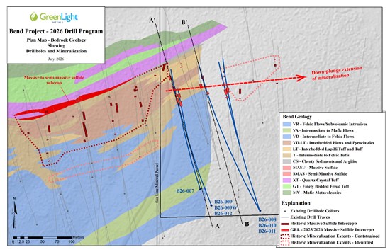
Figure 1: 2026 Drill Program Plan Map
To view an enhanced version of this graphic, please visit:
https://images.newsfilecorp.com/files/7506/306018_e1e40b20f40beaa2_001full.jpg
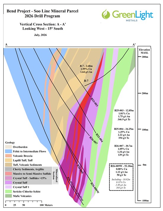
Figure 2: Generalized Geologic Cross Section A-A'
To view an enhanced version of this graphic, please visit:
https://images.newsfilecorp.com/files/7506/306018_e1e40b20f40beaa2_002full.jpg
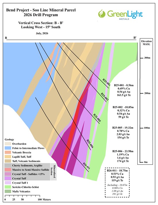
Figure 3: Generalized Geologic Cross Section B-B'
To view an enhanced version of this graphic, please visit:
https://images.newsfilecorp.com/files/7506/306018_e1e40b20f40beaa2_003full.jpg
Table 1: Summary of Significant Intercepts - Holes B26-009, B26-009W and B26-011
| DDH | From
(m) | To
(m) | Interval
(m) | Cu
(%) | Au
(g/t) | Ag
(g/t) | Te
(g/t) | CuEq
(%) |
| B26-009 | 415.00 | 457.12 | 42.12 | 0.11 | 1.31 | 2.52 | 59.92 | 1.50 |
| Including | 416.00 | 431.40 | 15.40 | 0.12 | 2.06 | 2.98 | 111.12 | 2.31 |
| B26-009W | 423.34 | 475.52 | 52.18 | 0.08 | 1.12 | 1.86 | 50.02 | 1.28 |
| Including | 423.34 | 434.16 | 10.82 | 0.11 | 2.49 | 2.65 | 103.21 | 2.75 |
| B26-011 | 423.40 | 442.15 | 18.75 | 0.53 | 0.93 | 5.81 | 118.76 | 1.52 |
| Including | 423.40 | 433.47 | 10.07 | 0.96 | 1.09 | 9.98 | 191.35 | 2.12 |
| Including | 429.08 | 433.47 | 4.39 | 1.27 | 1.65 | 15.99 | 235.12 | 3.06 |
1 Composite grades are calculated on a length-weighted basis and reported as drilled thicknesses. True thicknesses are estimated to be approximately 75%-85% of drilled thickness.
2 Copper Equivalent ("CuEq") is reported to express the aggregate in-situ value of copper, gold and silver as a percentage copper grade. CuEq incorporates assumed metallurgical recoveries and is not a proxy for, nor evidence of, economic value. Tellurium ("Te") is reported separately and is not included in CuEq.
CuEq (%) = ((Cu grade (%) / 100 × 0.9 (recovery) × 2204.6 × US$4.50) + (Au grade (g/t) × 0.9 (recovery) / 31.1035 × US$3,600) + (Ag grade (g/t) × 0.9 (recovery) / 31.1035 × US$40)) / (2204.6 × 0.01 × US$4.50).
Assumptions: metal prices of US$4.50/lb Cu, US$3,600/oz Au and US$40/oz Ag; recoveries of 90% for Cu, Au and Ag based on the Company's preliminary assessment of analogous VMS deposits. No allowances have been made for smelting or refining charges, penalties, deleterious elements or payability factors. No metallurgical test work has been completed at Bend; actual recoveries and payabilities are unknown and may differ materially.
Hole Details
- B26-009: Designed to undercut B26-007 (30.70m grading 1.05% Cu and 1.34 g/t Au). The mineralized interval is approximately 75 metres down-dip from B26-007. The hole was terminated within the mineralized interval due to mechanical issues with the drill rig.
- B26-009W: A wedge was set at approximately 299m in B26-009 to re-drill the mineralized section and advance through the full mineralized zone. The B26-009 and B26-009W traces remained less than approximately six metres apart through the mineralized interval.
- B26-011: Designed to undercut B25-006 (23.98m grading 1.19% Cu and 1.60 g/t Au) and test the down-plunge continuation of the copper-rich massive to semi-massive sulfide horizon.
Next Steps
- Pending Assays: Assay results for B26-012 are pending. Results for B26-013 will be reported following completion, sampling, receipt and validation.
- Drilling Ongoing: Two diamond core rigs continue to test the Soo Line mineral parcel, with current drilling focused on the projected 45°-50° eastward plunge and extensions of the copper-rich VMS horizon.
Table 2: Drill Collar Information
| Hole ID | Northing | Easting | Elevation | Azimuth | Dip | Total Depth |
| (m) | (m) | (masl) | (m) |
| B26-007 | 5018525 | 688500 | 415 | 344 | 65 | 391.972787 |
| B26-008 | 5018488 | 688602 | 412.13 | 343 | 67 | 538.581583 |
| B26-009 | 5018496 | 688519 | 414.27862 | 343 | 68 | 459.028785 |
| B26-009W | 5018496 | 688519 | 414.2782 | 345 | 59 | 520.598383 |
| B26-010 | 5018488 | 688602 | 412.13 | 343 | 63 | 522.122383 |
| B26-011 | 5018488 | 688602 | 412.12 | 333 | 64 | 523.036783 |
| B26-012 | 5018496 | 688519 | 414.2782 | 343 | 74 | 569.061582 |
| B26-013 | 5018496 | 688715 | 406.40435 | 344 | 57 | 264 (in progress) |
| B26-014 | 5018572 | 688597 | 410.12584 | 342 | 60 | 413.918387 |
Coordinates in NAD83 UTM Zone 15N. Final survey data pending.
About the Bend Project
The Bend VMS Project is an advanced exploration-stage copper-gold project in Taylor County, Wisconsin. A 1992 historical estimate outlined approximately 4.0 million tonnes grading 1.74% Cu, 2.44 g/t Au and 11.56 g/t Ag3. GreenLight's 2025 drilling included B25-004, which returned 34.25m grading 1.35% Cu, 2.22 g/t Au, 15.62 g/t Ag and 193.22 g/t Te.
3 Historical estimate. Primary source: E.K. Lehmann and Associates, Inc. (1992), Report of the geology and ore reserves of the Bend copper-gold deposit, Taylor County, Wisconsin, prepared for the Jump River Joint Venture. The estimate was prepared from approximately 33 diamond drill holes using polygonal and cross-sectional methods; no cut-off grade was stated. The estimate does not comply with CIM Definition Standards required by NI 43-101 and has no comparable current mineral resource classification. A Qualified Person has not completed sufficient work to classify the estimate as current, and the Company is not treating it as a current mineral resource. Significant data compilation, re-drilling, re-sampling and verification would be required before any current classification. Investors should not rely on the historical estimate.
Sample Preparation and QA/QC
A strict chain of custody was maintained from core collection through delivery to ALS Global's ("ALS") independent laboratory in Twin Falls, Idaho. NQ-size drill core (47.6mm diameter) was delivered to GreenLight's core facility in Medford, Wisconsin, where it was logged and sampled by Company geologists. Core was cut lengthwise using an electric saw; one half was placed in sealed sample bags for analysis and the remaining half was retained. Certified reference materials and blanks were inserted into the sample stream and together represented approximately 10% of submitted samples. Samples were shipped by ground courier directly to ALS.
Samples were prepared using ALS method PREP-31Y: crushing to 70% passing 2mm, rotary splitting of a 250g sub-sample and pulverizing the split to 85% passing 75µm. Gold was analyzed using ALS method Au-ICP21, a 30g fire assay with an ICP-AES finish and an upper detection limit of 10 ppm Au. Samples exceeding the upper limit were re-analyzed using a gravimetric finish. Multi-element analysis was completed using ALS method ME-MS61, a 0.25g four-acid digestion with ICP-MS/ICP-AES determination for 48 elements. Samples returning more than 1% Cu were re-analyzed using ALS method Cu-OG46, a 0.4g aqua-regia digestion with an ICP finish and an upper detection limit of 50% Cu.
Qualified Person Statement
The technical information in this news release has been prepared in accordance with Canadian regulatory requirements as set out in National Instrument 43-101 - Standards of Disclosure for Mineral Projects and reviewed and approved by Thomas Quigley, MSc, CPG-11962, Exploration Director of the Company, a Qualified Person as defined by NI 43-101.
About GreenLight Metals Inc.
GreenLight is a Wisconsin-focused exploration company advancing copper-gold and gold projects across the Penokean Volcanic Belt (one of North America's most prospective VMS districts) and the Kalium Canyon epithermal gold project in Nevada's Walker Lane, which is subject to a binding term sheet for a proposed staged earn-in and joint venture with Barrick Mining Corporation. In Wisconsin, GreenLight's portfolio includes the Bend copper-gold deposit, the Reef high-grade gold project, and the Lobo and Lobo East massive sulfide targets. GreenLight's flagship Bend Project is posted on the U.S. Federal Permitting Dashboard as a FAST-41 Transparency Project, providing a public framework for tracking applicable federal review and authorization milestones and coordinated support through the Permitting Council. Guided by a team with deep roots in the state, GreenLight is building a modern minerals company for Wisconsin, by Wisconsin, committed to responsible exploration, transparent engagement, and creating durable local opportunities as it helps supply the critical metals that power the energy transition.
Neither TSX Venture Exchange nor its Regulation Services Provider (as that term is defined in the policies of the TSX Venture Exchange) accepts responsibility for the adequacy or accuracy of this news release.
Cautionary Statement Regarding Forward-Looking Information
This news release contains forward-looking statements and forward-looking information within the meaning of applicable securities laws (collectively, "forward-looking statements"). All statements in this news release, other than statements of historical fact, are forward-looking statements and are based on the opinions and estimates of management as of the date hereof.
Forward-looking statements in this news release include statements regarding the timing for receipt and reporting of assay results from B26-012 and B26-013; the interpretation and significance of assay results, visual observations, geological relationships and mineralized intervals; the continuity, extension and open nature of mineralization; the planning, timing, scope and objectives of ongoing and future drilling, including the use of two drill rigs and any additional approximately 2,000 metres of drilling; the Company's ability to obtain and maintain required permits and approvals; and the advancement and potential of the Bend Project.
Forward-looking statements are based on assumptions management believes are reasonable as of the date hereof, including assumptions regarding laboratory turnaround times, the Company's ability to execute planned work safely and on schedule, the availability of equipment, contractors and personnel, access to the property, financing availability, and prevailing commodity prices and market conditions. Forward-looking statements are inherently subject to known and unknown risks, uncertainties and other factors that may cause actual events or results to differ materially, including delays or unexpected results from assays; differences between visual estimates and assay results; inaccuracies in geological models; changes in project parameters, plans or budgets; cost escalation; availability of drill rigs, contractors and supplies; adverse weather; operational, health, safety and environmental risks; title, access and permitting risks; stakeholder, community or Indigenous engagement risks; regulatory changes; and fluctuations in commodity prices and currency exchange rates. Additional risks are described in the Company's public disclosure documents filed on SEDAR+.
Readers are cautioned not to place undue reliance on forward-looking statements. The Company disclaims any intention or obligation to update or revise forward-looking statements except as required by applicable law.
To view the source version of this press release, please visit https://www.newsfilecorp.com/release/306018

© 2026 Canjex Publishing Ltd. All rights reserved.