Toronto, Ontario--(Newsfile Corp. - October 21, 2026) - Lavras Gold Corp. (TSXV: LGC) (OTCQX: LGCFF) ("Lavras Gold" or the "Company") announces that it has approved a fourth diamond drill rig to begin initial drill testing of the newly identified Cerrito North target at its Lavras do Sul Project ("LDS Project" or the "Project") in Rio Grande do Sul, Brazil. The Company also remains on track to submit its Fazenda-Butia LP application by the end of December 2026. Located approximately two kilometres north-northwest of the Cerrito deposit and on the northern continuation of the Caneleira trend, Cerrito North extends the Company's systematic testing of this district-scale corridor.
"Cerrito North is a key result of this year's broader geological work and warrants prompt drill testing," said Federico Velásquez, President and Chief Executive Officer of Lavras Gold. "Located on the northern continuation of the Caneleira trend, approximately two kilometres north-northwest of the Cerrito deposit, it reinforces the district-scale opportunity we are testing. Its large gold and multi-element soil anomaly, favourable geology, structural and geophysical characteristics, historical workings and rock samples returning up to 6.52 g/t gold provide a compelling case for drilling."
"Approving a fourth rig puts our commitment to the full potential of Lavras do Sul into action. Three rigs remain focused on expanding Caneleira's mineralized footprint to support potential additions to our resource inventory, while the fourth is dedicated to testing targets across the broader district. These complementary priorities advance our strategy: grow the resource base to support our development ambitions and systematically test the discovery potential of our landholdings."
"Submitting the Fazenda-Butia LP application by year-end remains a key priority, and we remain committed to that deadline. The Fundação Estadual de Proteção Ambiental (FEPAM), the environmental authority of the State of Rio Grande do Sul, has granted an extension of the Terms of Reference. This shows our good standing and reaffirms we are fit for purpose to accomplish our commitment to submit the LP application by end of year."
"Cerrito North combines a 1.6-kilometre gold-in-soil anomaly with the geochemical and geophysical indicators we use to identify new drill targets," commented Jonathan Hill, Director and Interim Vice President of Exploration. "The anomaly carries the same tungsten-molybdenum-antimony association we see over the mineralized corridors at Caneleira and Cerrito and coincides with a magnetic low of the kind that has consistently guided us to altered ground across the district. Rock samples collected at historical workings returned 4.49 grams per tonne gold within the anomaly and 6.52 grams per tonne gold approximately 900 metres east of it, providing further evidence of gold mineralization in the wider target area."
"Twenty-two shallow test holes are the right first step. At this stage, we want to determine whether the surface geochemistry is underlain by mineralized bedrock, not define continuity. Our structural work has identified two clear orientations to test, and the results will directly inform the ranking of targets for 2027," added Jonathan Hill.
Highlights:
Fourth diamond drill rig approved. Three rigs will continue developing the consolidated Caneleira system, while one rig will advance regional targets, beginning with Cerrito North. The additional capacity allows systematic testing of targets generated by the district-scale geochemical framework announced on October 13, 2026, without reducing the pace of drilling at Caneleira.
The Company has approved a first pass diamond drilling programme of 2,000 metres ("m") in 22 holes at Cerrito North. Holes are planned at 70m to 150m depth and are laid out to test the two structural domains identified at the target in their respective orientations.
Cerrito North lies approximately two kilometres ("km") north-northwest of the Cerrito deposit, which hosts Indicated mineral resource estimate of 8.3 million tonnes ("Mt") grading 0.70 grams per tonne ("g/t") Au containing 188,000 ounces ("oz") of Au and an Inferred mineral resource estimate of 13.2Mt grading 0.69 g/t Au containing 293,000 oz Au, and sits on the northern continuation of the Caneleira trend, as described in the Company's news release dated October 13, 2026.
The target pipeline now being drilled originates from the specialist technical workshop held in April 2026 (see news release date May 12, 2026), at which the Company committed to integrating over 20 years of legacy data into a unified district-scale model and to expanding the integration of geochemical, geophysical and spectral datasets. Cerrito North is the first target to be drill tested under that approach.
Integrated targeting and vectoring. Target generation and drill planning now combine multi-element soil and drill core geochemistry, airborne magnetics and gamma-ray spectrometry, and spectral geology in a single district-scale model, used both to rank new targets and to vector within the known deposits. A LiDAR topographic survey has been flown over the Project and the data are in final processing, after which they will be incorporated into the same model.
Multiple converging indicators. Within the target outline, 368 soil samples analyzed by fire assay define a gold anomaly approximately 1,600m long by 400m wide above a 100 ppb Au threshold. The anomaly coincides with favourable geophysical and structural features, historical workings and rock samples returning up to 6.52 g/t Au, including 4.49 g/t Au from an historical excavation within the anomaly. Results include:
53 samples above 100 ppb Au, 15 samples above 500 ppb Au and eight samples above 1,000 ppb Au, to a maximum of 4,030 ppb Au; and
a 95th percentile of 263 ppb Au against a median of 10 ppb.
Compared with the remainder of the Project analyzed by the same laboratory and the same analytical method, samples above 100 ppb Au are approximately 4.5 times more frequent at Cerrito North, samples above 500 ppb approximately eight times more frequent, and samples above 1,000 ppb approximately 12 times more frequent.
Geochemical signature. The Au anomaly is accompanied by elevated tungsten, molybdenum and antimony - median values of approximately 3.9, 2.3 and 2.1 times the Project background respectively, on a method-matched basis - together with weaker arsenic and silver. This is the same W-Mo-Sb-As association interpreted in the October 13, 2026 news release as marking late, structurally confined corridors where the granodiorite-related and potassium-rich granite-related systems overlap.
Geophysics. The target coincides with a magnetic low in the tilt derivative of the Company's magnetic data. Destruction of magnetite is a recognized component of the alteration associated with gold mineralization at the LDS Project, and magnetic lows have been the most consistent geophysical vector to mineralized zones across the district.
Rock sampling and historical workings. Twelve rock samples collected across the target area returned up to 6.52 g/t Au, with three samples above 1 g/t Au. At the western end of the gold-in-soil anomaly, a sample taken from a historical excavation returned 4.49 g/t gold. The highest sample, 900m east of the anomaly, returned 6.52 g/t gold together with >100 g/t silver, 3,792 ppm lead and 573 ppm zinc - the Au-Pb-Zn-Ag association described in the October 13, 2026 news release. Rock samples are selective by nature and are not necessarily representative of the mineralization present on the property.
Soil and rock geochemical results are exploration indicators only and do not establish the extent or continuity of underlying mineralization. They are not mineral resources, and there is no certainty that the drilling described in this release will intersect gold mineralization or result in the definition of a mineral resource.
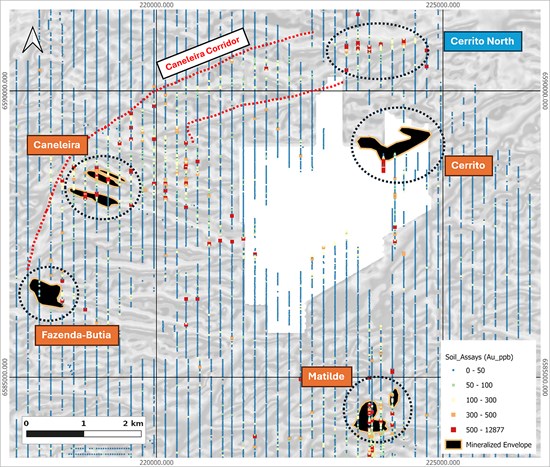
Figure 1 - Gold-in-soil geochemistry across the Lavras do Sul Project, showing the Cerrito North target on the northern continuation of the Caneleira corridor and approximately 2km north-northwest of the Cerrito deposit. Drill-defined mineralized envelopes are outlined at Fazenda-Butia, Caneleira, Cerrito and Matilde. Soil values are gold in parts per billion and combine results from more than one laboratory and analytical method, as reported. Background is the tilt derivative of the Company's airborne magnetic data in greyscale. Grid WGS 84 / UTM zone 22S; grid lines are spaced 5km apart. White areas are gaps in the background raster and do not indicate an absence of soil sampling.
To view an enhanced version of this graphic, please visit:
https://images.newsfilecorp.com/files/10429/320093_fcc46cbbb44b3a41_002full.jpg
The Cerrito North Target
Cerrito North is located in the northeastern part of the Lavras do Sul intrusive complex, approximately 2km north-northwest of the Cerrito Mineral Resource and on the northern continuation of the trend linking Fazenda-Butia, Caneleira and Cerrito. Independent re-processing and statistical levelling of the Company's soil geochemical database, reported on October 13, 2026, identified Cerrito North as the first new target to emerge from the district-scale framework.
Local Geology and Structure
The target area is underlain by monzogranite, one of the intrusive phases of the Lavras do Sul complex. Alteration mapped and sampled at surface is dominated by sericite with variable silica, accompanied by hematite and fine disseminated pyrite. Boxwork after sulphides is widespread in the weathered exposures and quartz veining is locally developed as stockwork. Galena occurs locally within the altered rock, consistent with the elevated lead returned by rock sampling, and fluorite has been tentatively identified in the field at the eastern end of the 100 ppb Au-in-soil contour.
Field structural measurements indicate two distinct structural domains across the target. In the western domain the dominant fabric is subvertical with a strike of 120° to 130°, interpreted to dip steeply towards 030° to 040°. In the eastern domain the fabric strikes 070° to 080°, coincident with the orientation of the magnetic low described below. The first pass drilling has been laid out to test both domains in their respective orientations.
Cerrito North remains an early-stage exploration target. No mineral resource has been estimated at Cerrito North, and drilling is required to determine whether the surface geochemical and geological indicators correspond to underlying gold mineralization.
Soil Geochemistry
Within the Cerrito North target outline, 368 soil samples were collected on the Company's regional grid and analysed by SGS GEOSOL using 30-gram fire assay combining an atomic absorption (AAS) finish, with a further 42 elements by multi-acid digestion and an ICP-OES/ICP-MS finish.
The October 13, 2026 news release referred to 1,212 samples covering the wider Cerrito North area - 186 analyzed by aqua regia digestion with an ICP finish and 1,026 by fire assay with an AAS finish. The values reported here relate only to the samples that fall within the target outline and were analyzed by fire assay, so that Au values are compared on a single analytical method.
Gold values range from below detection to 4,030 ppb, with a median of 10 ppb, a 90th percentile of 150 ppb and a 95th percentile of 263 ppb.
Fifty-three samples returned more than 100 ppb Au. These define a coherent anomaly of approximately 1,600m long by 400m wide.
The eight highest values, all above 1,000 ppb Au, are clustered over approximately 1,400m of strike in the western and central parts of the anomaly.
Comparisons of element tenor between Cerrito North and the remainder of the Project have been made only between samples analyzed by the same laboratory and digestion, because the Project database combines aqua regia and multi-acid results that are not directly comparable for many elements.
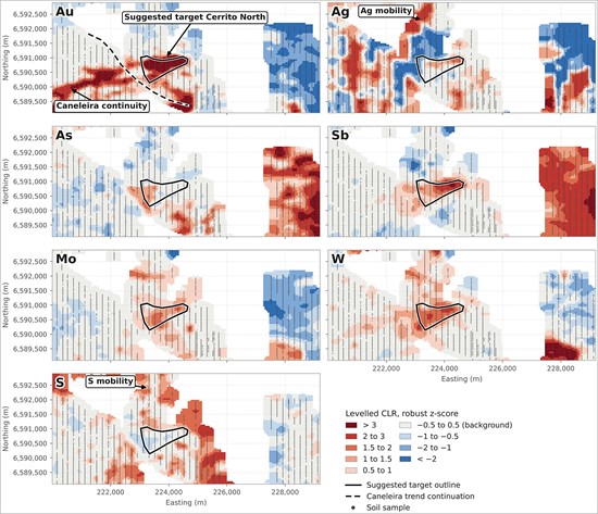
Figure 2 - Levelled multielement soil residuals over the Cerrito North area for gold, silver, arsenic, antimony, molybdenum, tungsten and sulphur, shown as robust z-scores of centred log-ratio values, with the suggested target outline and the interpreted continuation of the Caneleira trend. Values are levelled compositional residuals and are not absolute concentrations. The levelling of the residualized values in this area requires recalibration, and the outline shown is conceptual. The target outline measures approximately 1,600m long by 400m wide.
To view an enhanced version of this graphic, please visit:
https://images.newsfilecorp.com/files/10429/320093_fcc46cbbb44b3a41_003full.jpg
Geophysical Signature
The Cerrito North target coincides with a magnetic low defined in the tilt derivative of the Company's magnetic data. Destruction of magnetite accompanies the hydrothermal alteration associated with gold mineralization at the LDS Project, and magnetic lows have proved the most consistent geophysical vector to mineralized zones across the district, including at the Company's more advanced targets. The magnetic low is elongate at approximately 070° to 080°, the same orientation as the structural fabric measured in the eastern part of the target.
Rock Sampling
Twelve rock samples were collected from outcrops, road cuts, drainage exposures and the walls of historical excavations across the Cerrito North target area between May and June 2026. Gold values range from below detection to 6.52 g/t Au, with three samples above 1 g/t Au and six above 0.1 g/t Au. Sample locations and values are shown in Figure 3 and set out in Table 1.
Two samples were collected at the western end of the gold-in-soil anomaly and returned 4.49 g/t and 0.11 g/t Au. The 4.49 g/t Au sample is silicified granite carrying fine pyrite and hematite, taken from a historical excavation within the anomaly.
A further two samples, from the wall of a separate historical trench approximately 100m east of the anomaly, returned <0.02 g/t and 0.02 g/t Au. Both are monzogranite altered to sericite and hematite with boxwork after sulphides.
Seven samples were collected between approximately 500m and 900m east of the anomaly, where altered monzogranite with sericite and silica alteration, boxwork after sulphides and local quartz stockwork veining returned up to 6.52 g/t Au. The 6.52 g/t Au sample was taken at a historical adit developed on the structure (Figure 5). One further sample, approximately 400m south of the anomaly, returned <0.02 g/t Au.
The highest gold value, sample 23464, also returned silver above the upper reporting limit of the method (>100 g/t), together with 3,792 ppm lead, 573 ppm zinc, 180 ppm copper, 397 ppm molybdenum and 3.4% sulphur. No over-limit silver re-assay has been completed and the true silver value may be higher. This is the Au-Pb-Zn-Ag association described in the October 13, 2026 news release as characteristic of the potassium-rich granite-related system.
Rock samples are selective by nature and the values reported are not necessarily representative of the mineralization present on the property.
Table 1. Rock sample results, Cerrito North
| Sample | Easting | Northing | Description | Au (g/t) | Ag (g/t) | Pb (ppm) | As (ppm) |
| 23451 | 223,481 | 6,589,889 | Altered saprolite/rock, road cut | <0.02 | 0.07 | 34 | 8 |
| 23452 | 223,339 | 6,590,639 | Altered granite, sericite + pyrite | 0.11 | 0.12 | 9 | 24 |
| 23453 | 223,191 | 6,590,782 | Silicified granite, fine pyrite + hematite | 4.49 | 0.91 | 20 | 8 |
| 23456 | 224,790 | 6,590,363 | Monzogranite, sericite-hematite, boxwork; wall of historical trench | <0.02 | <0.02 | 49 | 97 |
| 23457 | 224,791 | 6,590,364 | Monzogranite, sericite-hematite, boxwork; wall of historical trench | 0.02 | <0.02 | 7 | 51 |
| 23458 | 225,222 | 6,590,177 | Monzogranite, silica-sericite, fine pyrite | 1.70 | 3.56 | 218 | 615 |
| 23459 | 225,222 | 6,590,189 | Monzogranite, silica-sericite, quartz stockwork | 0.15 | 1.54 | 10 | 32 |
| 23460 | 225,292 | 6,590,219 | Monzogranite, silica-sericite, boxwork | 0.25 | 3.77 | 59 | 157 |
| 23461 | 225,371 | 6,590,249 | Monzogranite, silica-sericite, boxwork | 0.02 | 0.13 | 11 | 95 |
| 23462 | 225,641 | 6,590,172 | Monzogranite, sericite-silica, disseminated pyrite; drainage | 0.07 | 2.01 | 9 | 97 |
| 23463 | 225,606 | 6,590,038 | Altered rock, sericite-silica, disseminated pyrite; road cut | 0.02 | 1.78 | 56 | 248 |
| 23464 | 225,605 | 6,590,142 | Altered rock, sericite-silica, disseminated pyrite; adit | 6.52 | >100 | 3,792 | 143 |
| Coordinates in WGS 84 / UTM zone 22S. Samples analysed by SGS GEOSOL Laboratórios Ltda. under certificates GY2603141 and GY2603863. Gold by fire assay on a 30 gram charge with an atomic absorption finish; silver and the remaining elements by multi-acid digestion with an ICP-OES/ICP-MS finish. "<" denotes a value below the lower detection limit of the method; ">" denotes a value above the upper detection limit. See the QA/QC section. |
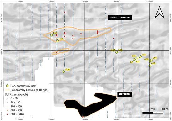
Figure 3 - Cerrito North work map showing the twelve rock sample locations with their gold values in g/t, the 100 ppb gold-in-soil contour that defines the target, individual soil sample values, and the drill-defined mineralized envelope at the Cerrito Mineral Resource approximately 2km to the south-southeast. Grid WGS 84 / UTM zone 22S. Background is the tilt derivative of the Company's airborne magnetic data in greyscale.
To view an enhanced version of this graphic, please visit:
https://images.newsfilecorp.com/files/10429/320093_fcc46cbbb44b3a41_004full.jpg
Planned Drilling
The approved programme comprises 2,000m of diamond drilling in 22 holes - 15 holes of 70m, two of 100m and five of 150m. The program is a first pass test of the target: its objective is to establish whether the gold-in-soil anomaly is underlain by mineralized bedrock at shallow depth, rather than to define continuity or to support the estimation of mineral resources. Planned collars are shown in Figure 4 and listed in Table 2.
Coverage. Collars are distributed over approximately 1,100m of strike along the Au-in-soil anomaly, between 223,218mE and 224,348mE, with the closest-spaced holes over the western part of the anomaly, where the highest Au-in-soil values and the 4.49 g/t rock sample occur.
Orientation and depth. All holes are planned at a dip of -60°. Eighteen holes are oriented at an azimuth of 170°, designed to cut the 070° to 080° structures of the eastern domain at a high angle, and four holes in the western part of the target are oriented at 220° to cut the 120° to 130° structures of the western domain. Planned depths of 70m to 150m are set to test the interpreted structures beneath the weathered profile.
Sequencing. The Cerrito North first pass programme forms part of the approximately 25,000m diamond drilling programme announced in the September 14, 2026 news release and does not represent additional metreage. The fourth rig provides the capacity to drill it in parallel, so that near-term drilling at the consolidated Caneleira Target continues at its planned pace.
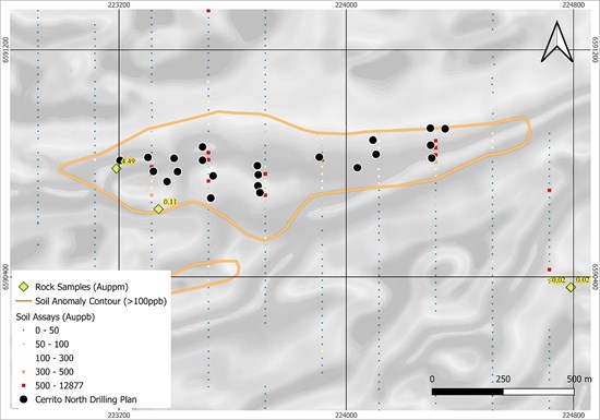
Figure 4 - Planned first pass drill programme at Cerrito North, showing the collar positions over the 100 ppb gold-in-soil contour, individual soil sample values and the rock sample locations. Collar positions are indicative and subject to confirmation in the field. Grid WGS 84 / UTM zone 22S. Background is the tilt derivative of the Company's airborne magnetic data in greyscale.
To view an enhanced version of this graphic, please visit:
https://images.newsfilecorp.com/files/10429/320093_fcc46cbbb44b3a41_005full.jpg
Table 2. Planned drill hole locations, Cerrito North
| Drill Hole | Easting | Northing | Elevation (m) | Azimuth (°) | Dip (°) | Planned Depth (m) |
| 26CRN001 | 223,302 | 6,590,821 | 378 | 170 | -60 | 70 |
| 26CRN002 | 223,687 | 6,590,792 | 359 | 170 | -60 | 70 |
| 26CRN003 | 223,321 | 6,590,772 | 385 | 170 | -60 | 70 |
| 26CRN004 | 223,690 | 6,590,760 | 365 | 170 | -60 | 70 |
| 26CRN005 | 223,406 | 6,590,771 | 388 | 170 | -60 | 70 |
| 26CRN006 | 223,689 | 6,590,721 | 362 | 170 | -60 | 70 |
| 26CRN007 | 223,394 | 6,590,818 | 372 | 170 | -60 | 70 |
| 26CRN008 | 223,696 | 6,590,697 | 364 | 170 | -60 | 150 |
| 26CRN009 | 223,369 | 6,590,736 | 373 | 220 | -60 | 70 |
| 26CRN010 | 223,905 | 6,590,822 | 370 | 170 | -60 | 70 |
| 26CRN011 | 223,494 | 6,590,858 | 368 | 170 | -60 | 70 |
| 26CRN012 | 223,523 | 6,590,678 | 369 | 220 | -60 | 150 |
| 26CRN013 | 223,494 | 6,590,811 | 370 | 170 | -60 | 70 |
| 26CRN014 | 224,297 | 6,590,864 | 360 | 170 | -60 | 150 |
| 26CRN015 | 224,094 | 6,590,882 | 366 | 170 | -60 | 150 |
| 26CRN016 | 224,296 | 6,590,924 | 359 | 170 | -60 | 150 |
| 26CRN017 | 224,105 | 6,590,832 | 361 | 170 | -60 | 70 |
| 26CRN018 | 224,348 | 6,590,922 | 350 | 170 | -60 | 100 |
| 26CRN019 | 224,039 | 6,590,785 | 365 | 170 | -60 | 70 |
| 26CRN020 | 223,520 | 6,590,739 | 373 | 220 | -60 | 70 |
| 26CRN021 | 224,310 | 6,590,770 | 346 | 170 | -60 | 100 |
| 26CRN022 | 223,218 | 6,590,796 | 393 | 220 | -60 | 70 |
| Coordinates in WGS 84 / UTM zone 22S. Collar positions, azimuths, dips and planned depths are as currently designed and are subject to confirmation in the field; actual collars may differ. |
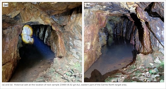
Figure 5 - (a) and (b) Historical adit developed on the structure sampled by rock sample 23464, which returned 6.52 g/t Au, >100 g/t silver, 3,792 ppm lead and 573 ppm zinc, in the eastern part of the Cerrito North target area. Iron-stained, sericite-silica altered monzogranite is exposed in the walls and back of the adit.
To view an enhanced version of this graphic, please visit:
https://images.newsfilecorp.com/files/10429/320093_fcc46cbbb44b3a41_006full.jpg
Relationship to the Cerrito Deposit
The Cerrito Deposit lies approximately 2km to the south-southeast of the Cerrito North target. Cerrito hosts an Indicated mineral resource estimate of 8.3Mt grading 0.70 g/t Au containing 188,000 oz Au and an Inferred mineral resource estimate of 13.2Mt grading 0.69 g/t Au containing 293,000 oz Au, reported at a Au cut-off grade of 0.30 g/t, as set out in the technical report referenced below.
The presence of mineral resources at the Cerrito Deposit is not indicative of mineralization at Cerrito North. No mineral resource has been estimated at Cerrito North and the geological and structural relationship between the two areas has not yet been established.
Four Rigs, Two Complementary Priorities
The fourth rig expands the Company's exploration capacity without changing its resource-development priorities. Three rigs remain focused on the consolidated Caneleira target, where drilling is designed to expand the known mineralized footprint and delineate additional mineral resources, with an emphasis on shallow, higher-grade mineralization that could potentially contribute to the Fazenda-Butia development project, subject to further resource definition and technical and economic studies. The fourth rig will test regional targets, beginning with Cerrito North, in parallel with that work.
Fazenda-Butia LP Application
As announced on September 14, 2026, Lavras Gold completed the Environmental Impact Assessment (EIA) field studies - the most critical and time-intensive component of the Environmental Impact permit application (LP) for the Fazenda-Butia Project.
The Company is pleased to report that on October 8, 2026, the Fundação Estadual de Proteção Ambiental (FEPAM), the environmental authority of the State of Rio Grande do Sul, granted a renewal of the Terms of Reference (DTREIA 25/2026, Proceso No. 8705-05 67/26.3) for the Fazenda-Butia EIA and LP Application, extending their validity by two years to October 7, 2028. While this renewal provides additional flexibility, the Company remains on track to submit its LP application by the end of December 2026.
By maintaining three rigs at Caneleira, adding dedicated drilling at Cerrito North and progressing the Fazenda-Butia LP application, the Company intends to advance resource growth, test new exploration opportunities and move its development objectives forward in parallel.
Integrated Targeting and Vectoring
Targets are now generated, ranked and drill planned from a single integrated dataset rather than from any one survey in isolation. The Company combines:
Geochemistry - levelled multielement soil and drill core data, used to define the district-scale corridor and the overlap zones that are the Company's principal targeting criterion, and to vector within known deposits using the Au-Cu-Bi-Ag and Au-Pb-Zn-As associations and their W-Mo-Sb-As overprint.
Geophysics - airborne magnetics, in which magnetic lows produced by magnetite destruction during hydrothermal alteration are a key indicator of mineralized systems, and gamma-ray spectrometry, which independently expresses the contact between the internal and external geochemical halos.
Spectral geology - identification of phengite, chlorite and other phyllosilicate alteration minerals central to the mineral system, allowing alteration intensity and mineral chemistry to be discriminated and the pathways that controlled gold-bearing fluids to be mapped.
LiDAR topography - a LiDAR survey has been flown over the Project and the data are in final processing. Once delivered, it is expected to define the subtle topographic lows that accompany the softer, more erodible phyllosilicate alteration associated with gold, and to improve the mapping of surface structures.
Together, these datasets support the generation and ranking of regional targets such as Cerrito North and improve three-dimensional vectoring within known deposits, including the plunging structural geometries identified at the specialist workshop.
Ongoing and Planned Work
Drilling continues at the consolidated Caneleira Target under the approximately 25,000m programme announced on September 14, 2026, while the Cerrito North first pass programme proceeds in parallel.
Recalibration of the levelling of the Cerrito North soil dataset is in progress.
An infill soil programme is planned over the priority overlap corridors identified by the October 13, 2026 interpretation, and the geochemical framework will be used to sequence further targets for drill testing through 2027.
Assay results from the first pass programme will be reported as they are received and interpreted.
Exploration elsewhere on the Project continues under the programmes described in the September 14 and October 13, 2026 news releases.
Qualified Person
Jonathan Hill, Director and Interim Vice President of Exploration for Lavras Gold Corp., is the "Qualified Person" as defined under National Instrument 43-101, Standards of Disclosure for Mineral Projects, and has reviewed and approved the technical information contained in this release.
QA/QC
Quality Assurance & Quality Control: Sample handling, preparation, and analysis are monitored through the implementation of formal chain-of-custody procedures and quality assurance/quality control programs designed to follow industry best practices.
Soil samples referred to in this release were collected from the B soil horizon on lines spaced 200 metres apart with samples at 25 metre intervals, tightening to a 50 by 50 metre grid in infill areas, with waterlogged ground avoided. The samples covering the Cerrito North target were submitted to SGS GEOSOL Laboratórios S.A. of Vespasiano, Minas Gerais State, Brazil, a laboratory accredited to ISO/IEC 17025:2017. Samples are dried, disaggregated and screened to 80 mesh, with the retained and passing fractions weighed, and 300g of the passing fraction is pulverized to 95% passing 150 mesh; gold is determined by 30g fire assay with an AAS finish and a further 42 elements by multi-acid digestion with an ICP-OES/ICP-MS finish. Certified reference materials and blanks are inserted into the soil sample stream at approximately 2% of samples submitted to SGS. Results are evaluated for accuracy, precision and contamination.
Rock samples reported in Table 1 were collected from outcrop, road cuts, drainage exposures, the wall of a historical trench and a historical adit, and were submitted to SGS GEOSOL Laboratórios Ltda. of Vespasiano, Minas Gerais State, Brazil, a laboratory independent of the Company and accredited to ISO/IEC 17025:2017, under certificates GY2603141 and GY2603863. Samples were crushed to 75% passing 3mm and a 250g split was pulverized to 95% passing 150 mesh. Gold was determined by fire assay on a 30 gram charge with an atomic absorption finish, reported to a lower detection limit of 0.02 g/t. A further 42 elements, including silver, lead, zinc, copper and molybdenum, were determined by multi-acid digestion (hydrochloric, nitric, hydrofluoric and perchloric acids) with an ICP-OES/ICP-MS finish; this digestion is partial for some refractory minerals and certain elements may be under-reported. Silver by this method is reported over the range 0.02 to 100 g/t. Sample 23464 returned silver above that upper limit and is reported as >100 g/t; no over-limit re-assay has been completed and the true silver value may be higher.
Soil geochemical sampling is a surface exploration technique. Soil anomalies reflect the dispersion of elements in the weathering environment and may be displaced from, or unrelated to, bedrock mineralization. Gold dispersion at the LDS Project is further affected by seasonal water table movement, which can concentrate gold at preferential horizons within the soil profile. Soil results are used by the Company as a targeting tool and are not used in the estimation of mineral resources, and are therefore not a substitute for drilling.
About the LDS Project
The LDS Project is centred on the town of Lavras do Sul in Rio Grande do Sul, Brazil. It is approximately 320 kilometres, or a 4.5-hour drive, from the state capital of Porto Alegre. The Company, through its subsidiary, holds, directly or indirectly, contractual interests over 31 mineral rights covering approximately 20,300 hectares.
The LDS intrusive complex is a multiphase intrusive centre surrounded by coeval volcanic rocks to the east. Geologically, LDS lies in the far south of the Neoproterozoic Mantiqueira Province, a 2,700-kilometre-long belt of tectonically and magmatically accreted terrains stretching as far south as the coastline of central Uruguay and north into southern Bahia State in Brazil. The most advanced targets are the Fazenda-Butia and Cerrito gold deposits. Fazenda-Butia hosts Measured mineral resources of 4.6 million tonnes grading 0.88 g/t gold containing 132,000 ounces of gold and Indicated mineral resources of 8.3 million tonnes grading 0.92 g/t gold containing 246,000 ounces of gold (total Measured and Indicated mineral resources of 12.9 million tonnes grading 0.91 g/t gold containing 377,000 ounces of gold) and Inferred mineral resources of 3.7 million tonnes grading 0.97 g/t gold containing 115,000 ounces of gold. Cerrito hosts Indicated mineral resources of 8.3 million tonnes grading 0.70 g/t gold containing 188,000 ounces of gold and Inferred mineral resources of 13.2 million tonnes grading 0.69 g/t gold containing 293,000 ounces of gold. Mineral resources are reported at a gold cut-off grade of 0.30 g/t and are set out in the technical reports 1 and 2 referenced below. Numbers may not sum due to rounding. Mineral resources are not mineral reserves and do not have demonstrated economic viability. No mineral resources have been estimated at Caneleira, Cerrito North or Matilde.
1. NI 43-101 Technical Report Mineral Resource for the Butiá Gold Prospect, Rio Grande do Sul, Brasil. Prepared by VMG Consultoria e Soluções Ltda., effective date January 25, 2022, amended report date November 15, 2024.
2. NI 43-101 Technical Report Mineral Resource for the Cerrito Gold Prospect, Rio Grande do Sul, Brasil. Prepared by VMG Consultoria e Soluções Ltda., effective date May 31, 2022, amended report date November 15, 2024. These reports are available on the Company's website and at www.sedarplus.ca under Lavras Gold's issuer profile.
About Lavras Gold Corp.
Lavras Gold Corp. is a Canadian exploration company focused on realizing the potential of its LDS Project situated in a highly prospective gold district in southern Brazil. The LDS Project is located near the town of Lavras do Sul in Rio Grande do Sul State, Brazil, and is primarily an intrusive-hosted gold system of possible alkaline affinity. More than 24 gold prospects centred on historic gold workings have been identified on the LDS Project properties, which span approximately 20,300 hectares. For more information on Lavras Gold visit www.lavrasgold.com.
On Behalf of Lavras Gold Corp.
"Federico Velásquez"
Disclaimer: Neither TSX Venture Exchange nor its Regulation Services Provider (as that term is defined in the policies of the TSX Venture Exchange) accepts responsibility for the adequacy or accuracy of this release.
Forward-looking statements: This news release includes certain "forward-looking information" within the meaning of Canadian securities legislation and "forward-looking statements" within the meaning of the United States Private Securities Litigation Reform Act of 1995 (collectively "forward-looking statements"). Forward-looking information in this news release includes, but is not limited to: statements regarding the mobilization, timing, capacity and expected contribution of a fourth diamond drill rig; the allocation of three rigs to the consolidated Caneleira system and one rig to regional targets; the Company's integration of geochemical, geophysical, spectral and LiDAR datasets and the expectation that this integration will improve target generation, ranking and three-dimensional vectoring and the Company's ability to accelerate drill testing across the district as a result; the commencement, scope, sequencing, metreage, hole count, depth and duration of the planned first pass drilling programme at Cerrito North and its relationship to the approximately 25,000m programme announced on September 14, 2026; the continuation of drilling at the consolidated Caneleira Target at its planned pace; the planned infill soil programme and the sequencing of further targets for drill testing through 2027; the interpretation of the soil, rock and geophysical data over Cerrito North, including the extent, continuity and significance of the gold-in-soil anomaly and of its pathfinder signature; the expectation that the target warrants drill testing and the objectives of that drilling; the interpreted geological and structural relationship between Cerrito North and the Cerrito Mineral Resource; the planned recalibration of the levelling of the Cerrito North soil dataset; the timing and receipt of assay results; the completion of the EIA technical reports and the submission of the Preliminary Environmental License application by December 2026 and its scope; and the continuation of drilling at the Caneleira Target.
Forward-looking statements are often, but not always, identified by the use of words such as "seek", "anticipate", "believe", "plan", "estimate", "forecast", "expect", "potential", "project", "target", "schedule", "budget" and "intend" and statements that an event or result "may", "will", "should", "could" or "might" occur or be achieved and other similar expressions and includes the negatives thereof. All statements other than statements of historical fact included in this release are forward-looking statements that involve various risks and uncertainties. Forward-looking information is based on management's current expectations and assumptions, including assumptions regarding the reliability and comparability of geochemical data generated by different laboratories and analytical methods, the validity of the statistical levelling applied to that data, exploration results, geological continuity, the availability of drill rigs, personnel and equipment, field and weather conditions, laboratory turnaround times, regulatory approvals, financing, commodity prices and the Company's ability to execute its exploration and development plans.
Actual results may differ materially as a result of exploration risk, the possibility that drilling does not intersect mineralization or does not confirm current geological or geochemical interpretations, the risk that soil geochemical, geophysical and rock sample results do not reflect the presence of economically recoverable mineralization, changes in project parameters as plans continue to be refined, results of future mineral resource estimates and technical studies, availability and cost of capital, changes in commodity prices, delays in laboratory results or regulatory approvals, title risks, environmental risks and other risks described in the Company's continuous disclosure filings. Although the Company has attempted to identify important factors that could cause actual actions, events or results to differ from those described in forward-looking statements, there may be other factors that cause such actions, events or results to differ materially from those anticipated. There can be no assurance that forward-looking statements will prove to be accurate and accordingly readers are cautioned not to place undue reliance on forward-looking statements. Except as required by applicable securities laws, the Company undertakes no obligation to update such information.

To view the source version of this press release, please visit https://www.newsfilecorp.com/release/320093

© 2026 Canjex Publishing Ltd. All rights reserved.