Vancouver, British Columbia--(Newsfile Corp. - August 25, 2026) - NRED Intelligent Mining Inc. (CSE: NRED) (OTCQB: NREDF) ("NRED" or the "Company") is pleased to report results of an integrated review of shallow airborne resistivity data and 926 classified soil samples from the Wilmac Copper-Gold Project (the "Project"), located in British Columbia's Quesnel porphyry belt, approximately 10 kilometres west of Hudbay Minerals Inc.'s producing Copper Mountain Mine.
The review strengthens NRED's working model suggesting that younger Princeton Group rocks may cover and obscure the older Nicola Group and intrusive rocks considered more favourable for exploration. The 40 kilohertz ("40 kHz") airborne apparent-resistivity data identify a broad, more conductive eastern domain interpreted to be influenced by Princeton Group cover, while the soil classifications provide much shallower, local-scale information that helps refine the transition toward more resistive basement ground.
"This analysis provides us with a clearer picture of where prospective basement rock may be exposed and where it may be hidden beneath younger cover," said Brian Goss, Chief Executive Officer of NRED Intelligent Mining Inc. "The airborne data provide the property-scale view, while the soils add local detail. Together, they give us a stronger framework for mapping, follow-up, and future drill targeting."
Key Results
926 soil samples were compared with the property-scale 40 kHz airborne resistivity dataset;
A 211 ohm-metre empirical screening division, representing the 30th percentile of the property-scale 40 kHz data, was used to distinguish relatively conductive from relatively resistive responses;
SED and QUAT soil groups returned median apparent resistivities of 288 and 311 ohm-metres respectively, with approximately 33% and 27% of sites below the 211 ohm-metre screening division;
The REG group, interpreted to retain a stronger Nicola-derived component, returned a higher median apparent resistivity of 383 ohm-metres, with only 11% of sites below the screening division; and
A detailed 2.5 by 1.8-kilometre North Lamont comparison containing 96 classified soil samples shows the expected broad relationship between cover-influenced soils, the conductive eastern domain, and the transition toward more resistive ground.
40 kHz Data Define a Broad Cover-Screening Pattern
The 40 kHz data are part of the 2008 Fugro RESOLVE helicopter survey (Rockel 2009; Saleken 2009) and principally reflect shallow electrical properties. Across the Project, lower apparent resistivity forms a coherent eastern domain that broadly corresponds with younger Princeton Group cover, while more resistive responses are more common over Nicola Group and intrusive ground to the west (Fig. 1).
For this review, 211 ohm-metres was selected as an empirical screening division. Values at or below this level are relatively conductive and potentially cover-influenced; values above it are relatively resistive and potentially more basement-influenced. The threshold is specific to the Wilmac dataset and is not a universal geological cutoff or a direct definition of the unconformity.
The contrast is expected to be strongest where Princeton Group rocks are thick and conductive enough to influence the airborne measurement. Thin, discontinuous, dry, or relatively resistive cover may produce a basement-like response. Conversely, conductive Quaternary material, clay, groundwater or conductive Nicola Group rocks may also produce low resistivity. The interpretation is therefore a cover-screening model, not a direct geological map.
926 Soil Samples Add Shallow, Local-Scale Control
NRED's 2025 review classified 926 soil samples into eight geochemical groups. Unlike the airborne system, which averages a broader shallow volume, each soil sample records material at a specific near-surface location. Lamont Ridge B-horizon soils were generally collected 15 to 30 centimetres below surface. This means soil chemistry can preserve useful local information even where remaining Princeton Group cover is too thin to dominate the airborne response.
The strongest relationship appears at the scale of broader soil groups and domains. SED and QUAT, which show weaker local bedrock control, returned median 40 kHz apparent resistivities of 288 and 311 ohm-metres, respectively. Approximately 33% of SED and 27% of QUAT sites occur below the 211 ohm-metre screening division. In comparison, REG, interpreted to retain a stronger Nicola-derived component, returned a median of 383 ohm-metres, with only 11% of sites below the division.
Other soil groups are consistent with the same broad framework. BVOL occurs farther inside the resistive domain, while AVOL, CUVOL and PXGB cluster closer to the regional geophysical transition. The PRGP classification remains provisional because its chemistry may reflect an organic-rich soil horizon rather than Princeton Group provenance. The results support a broad cover-versus-basement framework but do not make individual soil classes direct bedrock maps.
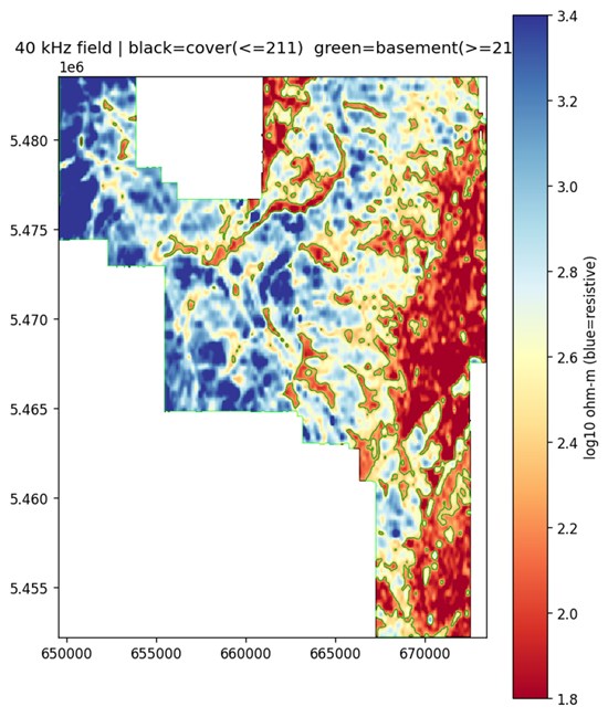
Figure 1 - Property-scale 40 kHz apparent resistivity. Blue areas are more resistive and red areas are more conductive. Green outlines distinguish values at or above the empirical 211 ohm-metre screening division. The outlines approximate the Nicola/Princeton Group transition for screening purposes and do not define geological boundaries.
To view an enhanced version of this graphic, please visit:
https://images.newsfilecorp.com/files/9977/311375_92ff4e8974c9783e_002full.jpg
North Lamont Example Shows the Relationship
A 2.5 by 1.8-kilometre North Lamont window was selected because both datasets have sufficient coverage for a useful comparison. The window contains 96 classified soil samples. AVOL, CUVOL and PXGB, which regionally cluster near the interpreted cover margin, follow the local resistivity transition, while SED and QUAT extend into the more conductive eastern portion of the window.
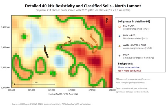
Figure 2 - North Lamont comparison of the 40 kHz apparent-resistivity field and 96 classified soil samples. SED and QUAT are grouped as cover- or transport-influenced; BVOL and REG as Nicola-associated; AVOL, CUVOL and PXGB as cover-margin classes; and PRGP as an ambiguous organic-rich class. The window illustrates the relationship where both datasets have useful coverage and is not presented as a blind validation test.
To view an enhanced version of this graphic, please visit:
https://images.newsfilecorp.com/files/9977/311375_92ff4e8974c9783e_003full.jpg
Why the Datasets Do Not Match Point-for-Point
The airborne survey and soil sampling measure different physical volumes and operate at different spatial resolutions. The 40 kHz system averages a broader shallow electrical response and requires sufficient thickness and conductivity contrast to recognize cover. A soil sample represents a much smaller and shallower location and may be affected by residual weathering, transported material, soil horizon and drainage.
The resistivity data were interpolated to a 60-metre grid from airborne survey lines, while soils were collected along field traverses and roads rather than a continuous grid. Local mismatches are therefore expected. The important result is the broader agreement in the position and character of the conductive cover domain, the resistive basement domain and the transition between them.
Interpretation and Next Steps
NRED considers the combined interpretation partially supported. The data support the use of 40 kHz apparent resistivity as a property-scale screen for areas where Princeton Group cover is sufficiently developed to generate a conductive response, with soil classification providing complementary shallow control. The data do not yet establish the exact unconformity position, cover thickness or bedrock identity at every location.
The Company plans to test the model using pre-selected field transects across the interpreted transition, incorporating geological mapping, shallow pits or auger holes, documented soil horizons and, where practical, ground conductivity or resistivity measurements. The 211 ohm-metre screening division will be tested against field observations rather than adjusted to fit them.
The refined cover model will be used to condition other exploration datasets. Geochemical, radiometric or magnetic responses occurring on interpreted Princeton Group ground will require geological evidence that they are developed in, or sourced from, underlying Nicola Group or intrusive rocks before being advanced. Neither the 40 kHz response nor any soil class identifies mineralization or predicts copper grade.
References
Rockel, E.R. (2009). Report on a Fugro Airborne Geophysical Survey, Tulameen Project, Assessment Report 31,585C, prepared for Goldcliff Resource Corporation by Interprex Resources Ltd., dated November 20, 2009, 60 p.
Saleken, L. (2009). Exploration Report on the Tulameen Project Property, Princeton Area, Similkameen Mining Division, British Columbia, Assessment Report 30899 for Goldcliff Resource Corporation, dated February 19, 2009, 254 p.
Qualified Person
The scientific and technical information in this news release, including the geological interpretations described herein, has been reviewed and approved by Rick Walker, P.Geo., a Qualified Person as defined by National Instrument 43-101 ("NI 43-101"). Mr. Walker is not independent of the Company within the meaning of NI 43-101. The interpretations described above are conceptual and rely in part on historical, third-party data that the Company has not independently verified. No mineral resources or mineral reserves have been identified on the Project.
About NRED Intelligent Mining Inc.
NRED Intelligent Mining Inc. (CSE: NRED) (OTCQB: NREDF) is a mineral exploration company focused on the identification, acquisition, exploration and development of copper-gold porphyry projects in British Columbia, leveraging an artificial intelligence-enhanced geospatial technology platform that it developed to identify and evaluate prospective mineral properties. The Company's optioned Wilmac copper-gold project comprises 16,078 hectares located within the Quesnel porphyry belt in the Similkameen Mining Division, southwest of Princeton and approximately 10 kilometres west of Hudbay Minerals Inc.'s producing Copper Mountain Mine.
Readers are cautioned that the discussion of mineralization, alteration or grades on adjacent, similar or analogous properties, including the Copper Mountain Mine, is not necessarily indicative of the mineralization or potential of the Wilmac Copper-Gold Project. The Company has no interest in, or right to acquire any interest in, any such properties.
FORWARD-LOOKING INFORMATION
This news release contains "forward-looking information" within the meaning of applicable Canadian securities legislation. Forward-looking information includes, but is not limited to, statements regarding: the interpretation of geological, geochemical and geophysical data, which were used to identify future exploration targets on the Wilmac Project; the inference that the combination of airborne survey resistivity data and soil sample results, as interpreted, suggest that the Wilmac Project may potentially host mineralized copper zones; the completion of additional analysis of past results and the completion of anticipated exploration on the Wilmac Project in the future, including exploration to test the Company's revised property model; and the Company's intention and ability to satisfy the cash payment, share issuance, and exploration expenditure milestones required to exercise the option agreements respecting the Wilmac Project.
Forward-looking information is based on a number of assumptions that, while considered reasonable by the Company at the date of this news release, are inherently subject to significant business, economic and competitive uncertainties and contingencies. Such assumptions include, without limitation: the accuracy of current geological interpretations, including the identified anomalies and structural corridors described in this news release; the accuracy and completeness of the third-party historical data on which the interpretation rests; the availability of adequate funding to complete the proposed exploration; the ability of the Company's geophysical contractors and geological consultants to complete contemplated exploration on schedule; favourable weather, terrain and field conditions; access to the Project area; the availability of qualified personnel; the receipt of all necessary permits and authorizations for planned exploration; and the continued cooperation of the optionors under the terms of the relevant option agreements.
Forward-looking information is subject to known and unknown risks, uncertainties and other factors that may cause actual results, performance or achievements to differ materially from those expressed or implied by such forward-looking information. Important risk factors include, but are not limited to: the possibility that the interpretations described are not ultimately accurate; additional exploration and drilling do not support the interpretation described; the continued availability of capital and financing; the ability to satisfy option earn-in requirements on the timelines contemplated; risks inherent in mineral exploration; adverse weather or terrain conditions; tenure grant, renewal and permitting outcomes, including under British Columbia's revised mineral tenure system; Indigenous and community consultation requirements; changes in applicable laws and regulations; the ability to retain key personnel and contractors; litigation; failure of counterparties to perform their contractual obligations; and general economic, market or business conditions. Readers are cautioned not to place undue reliance on forward-looking information. The Company undertakes no obligation to update or revise any forward-looking information, except as required by applicable securities laws.
Neither the CSE nor its Market Regulator (as that term is defined in CSE policies) accepts responsibility for the adequacy or accuracy of this news release.

To view the source version of this press release, please visit https://www.newsfilecorp.com/release/311375

© 2026 Canjex Publishing Ltd. All rights reserved.