VANCOUVER, British Columbia, July 30, 2026 (GLOBE NEWSWIRE) -- Oroco Resource Corp. (TSX-V: OCO; OTC: ORRCF) (“Oroco” or the “Company”) is pleased to report preliminary results from reconnaissance rock-chip sampling and geological mapping at the Vainilla Project in northern Sinaloa, Mexico, including one selective sample from the El Platano breccia pipe that returned 7.57% copper. The Company has also completed a high-resolution drone magnetometry survey over the property.
Highlights
- Mapping and sampling have advanced the definition of three principal mineralized areas: El Platano, Mazomique and Cristina.
- One selective rock-chip sample from a historical working at El Platano returned 7.57% copper; the sample is not representative of the overall grade or continuity of mineralization.
- El Platano is interpreted as a mineralized breccia body hosting copper-iron oxides, secondary copper minerals, precious metal anomalies, quartz-tourmaline brecciation within a broad propylitic alteration halo in andesitic volcanics.
- Mapping surrounding Mazomique has identified magnetite-pyrite-chalcopyrite mineralization and copper oxides associated within exo-skarns exposed in previous mining operations.
- At Cristina, a structurally controlled breccia is host to anomalous gold, silver, copper and lead.
- A property-wide, high-resolution drone magnetic survey has been completed to assist in defining structural, intrusive, porphyry and skarn-related exploration targets.
The geological program identified structurally controlled veining, skarn hosted copper mineralization and brecciation, hydrothermal alteration and polymetallic mineralization across the property. At El Platano, copper mineralization is exposed in surface outcrops and historical artisanal mine workings within an alteration feature presently mapped over approximately 600 metres by up to 250 metres. These dimensions describe the mapped alteration and do not imply continuous mineralization.
“While our primary focus remains the advancement of Santo Tomás, the preliminary results at Vainilla support further systematic evaluation of this property,” said Oroco CEO Charles Cryer. “The combination of a selective high-grade copper sample at El Platano, widespread alteration and several distinct mineralized prospects provide a basis for disciplined target development. The proximity to Santo Tomás may also offer logistical benefits if future exploration is successful.”
Vainilla Project Progress
The 2,973.7-hectare Vainilla concession lies approximately eight kilometres east of Choix and approximately 17 kilometres south of the South Zone of Oroco’s Santo Tomás Project, within the Santo Tomás cluster of the belt of Laramide orogenic-association porphyry intrusions (Figure 1). The Company holds an option to acquire a 100% interest in the Vainilla concession, subject to final approval by the TSX Venture Exchange.
Note that the Company does not hold rights or title to the La Alicia, El Rosario and Cuauhtemoc concessions (total area of 78.75 ha) internal to the Vainilla concession. Sampling at the La Alicia concession were taken with the consent of the concession holder.
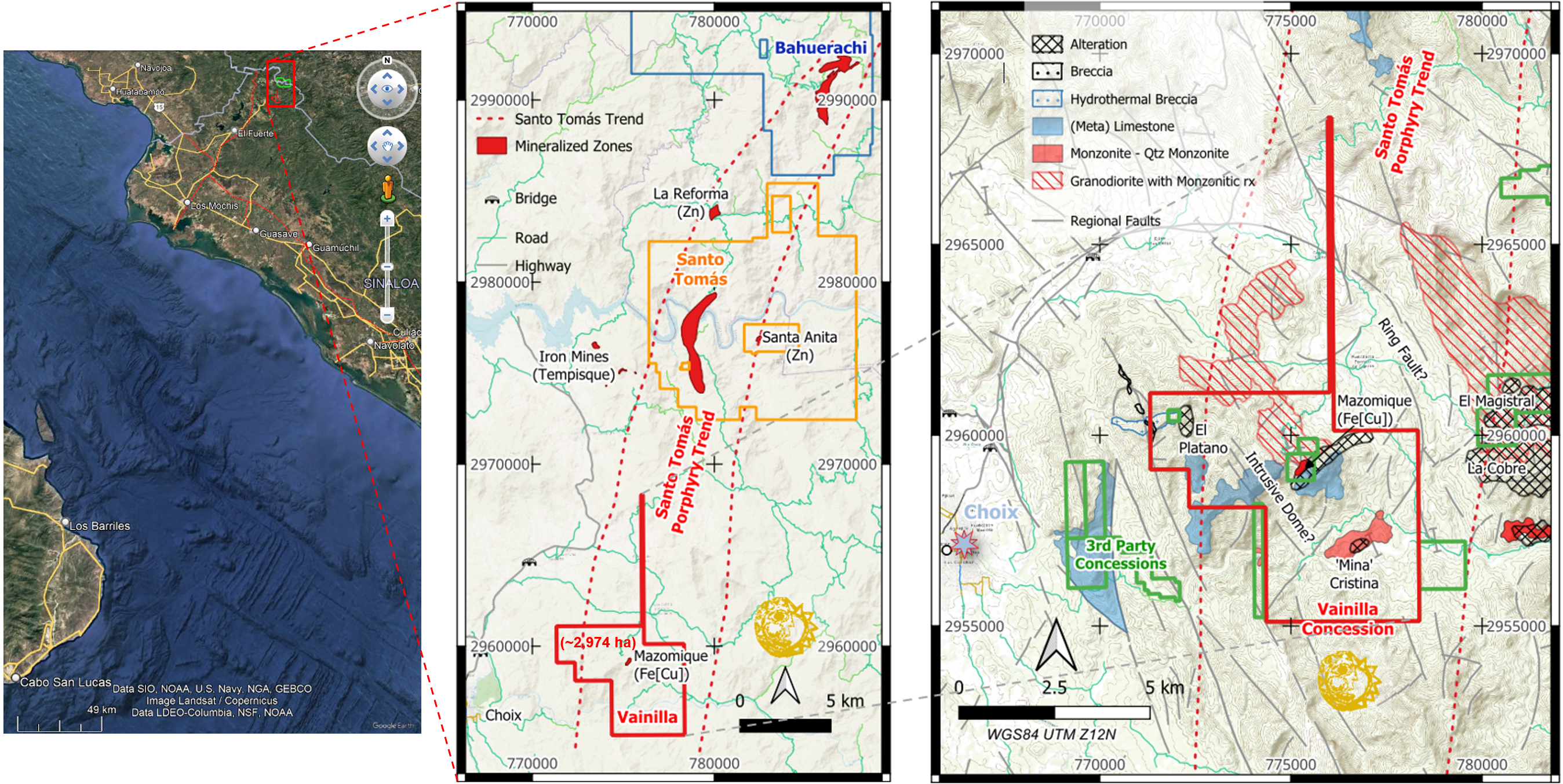
Figure 1: Location of the Vainilla concession, northern Sinaloa (left); its location relative to the Santo Tomás and Bahuerachi porphyry copper occurrences and concessions (centre) and relative to Choix (right).
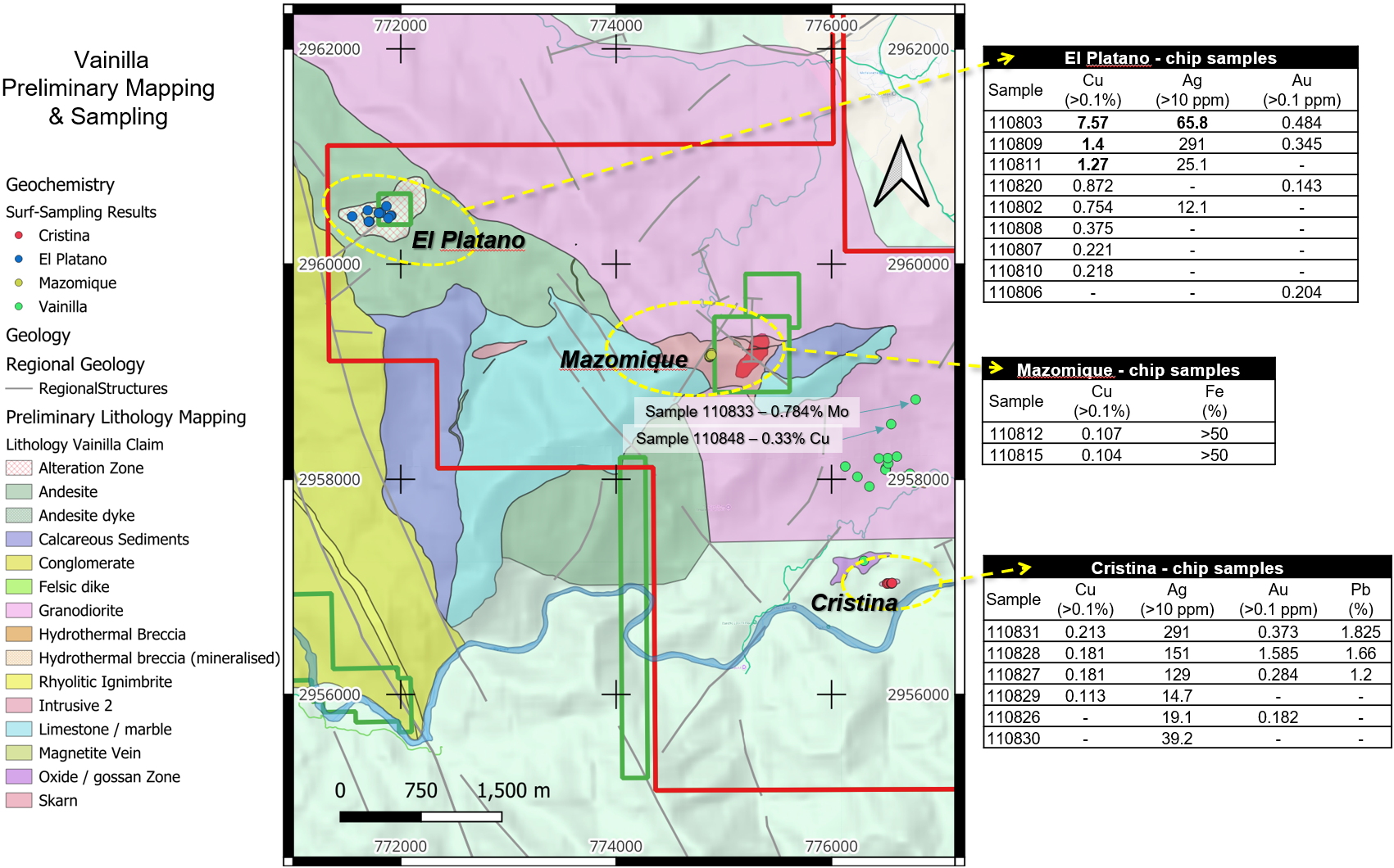
Figure 2: Preliminary geological mapping and sampling on the Vainilla concession showing results for selected samples based upon threshold assays for Cu, Au, Ag and Pb. The displayed samples are selective and are not representative of the overall grade or continuity of mineralization. The sampling program was designed to identify areas that may warrant further work and was not designed to establish average grades, widths or a mineral resource.
Copper and local gold and silver values occur at El Platano. Additional mapping, sampling and geophysical interpretation are required to assess the extent, distribution and geological controls of mineralization before drill targets can be finalized.
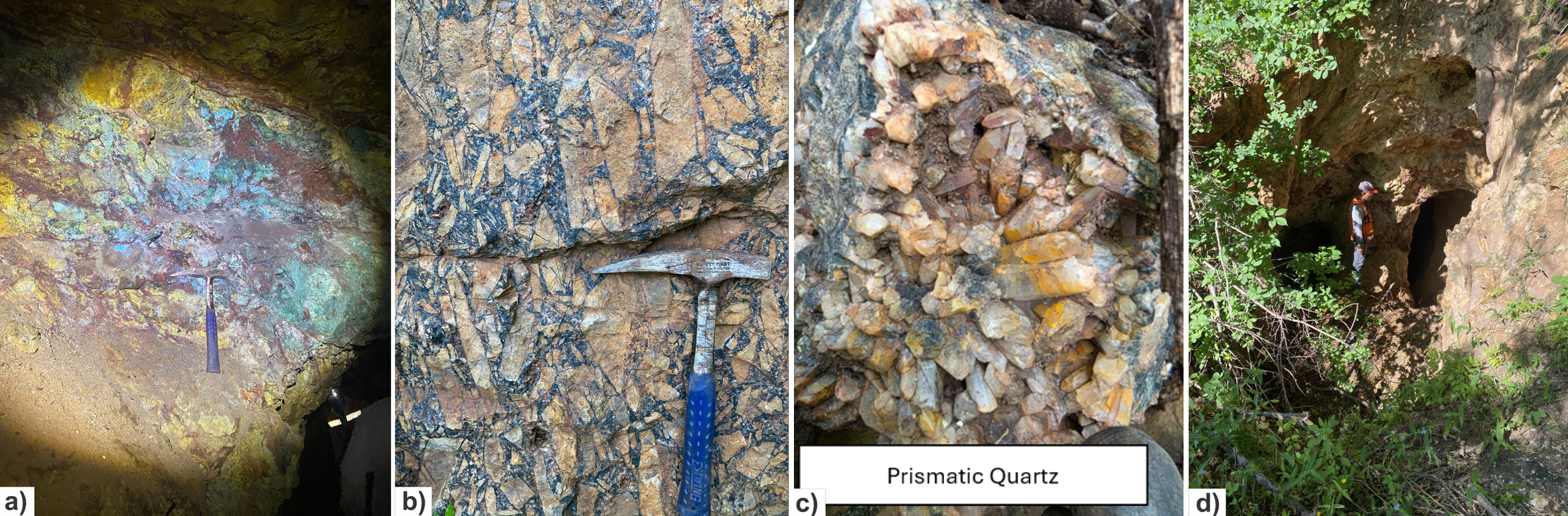
Figure 3: a) Mineralized zone of the El Platano breccia with high content of Cu-Fe oxides (sample 110803); b) Unmineralized breccia with jigsaw/mosaic texture cemented by quartz-tourmaline, El Platano; c) Prismatic quartz at the El Platano breccia pipe; and d) Adit access at Cristina.
At Mazomique, chalcopyrite occurs with pyrite and magnetite in veins of replacement-style mineralization. The significance and extent of this mineralization remain to be determined through further fieldwork and integration with the drone magnetic data.
Copper and molybdenum values were returned from selective samples of intrusive breccia east-southeast of Mazomique and warrant follow-up mapping and sampling.
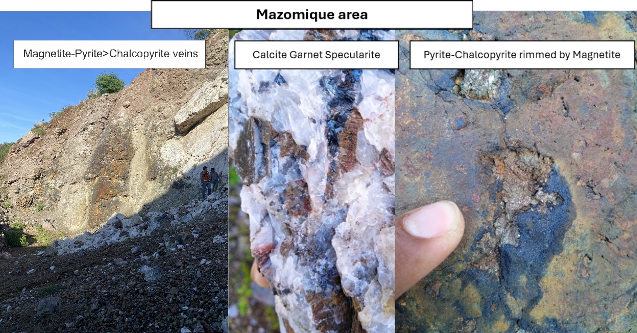
Figure 4: Field photographs from Mazomique prospect. The left photograph, looking north-northwest, shows magnetite-sulfide-oxide replacement-style mineralization; the darker magnetite-bearing exposure is approximately 35 metres high.
Drone Magnetic Survey
The drone survey covered approximately 3,114 hectares and comprised approximately 707-line kilometres, including 390 survey lines spaced 100 metres apart, and 35 tie lines (Figure 5). The data were processed to generate total magnetic intensity, reduced-to-pole and derivative products, together with preliminary three-dimensional magnetic susceptibility and magnetic-vector inversion models.
Preliminary interpretation identifies a complex northwest-trending structural and intrusive framework and three principal areas of interest with magnetic characteristics that may be consistent porphyry and skarn systems. These interpretations are preliminary and require integration with geological mapping, geochemistry and field verification.
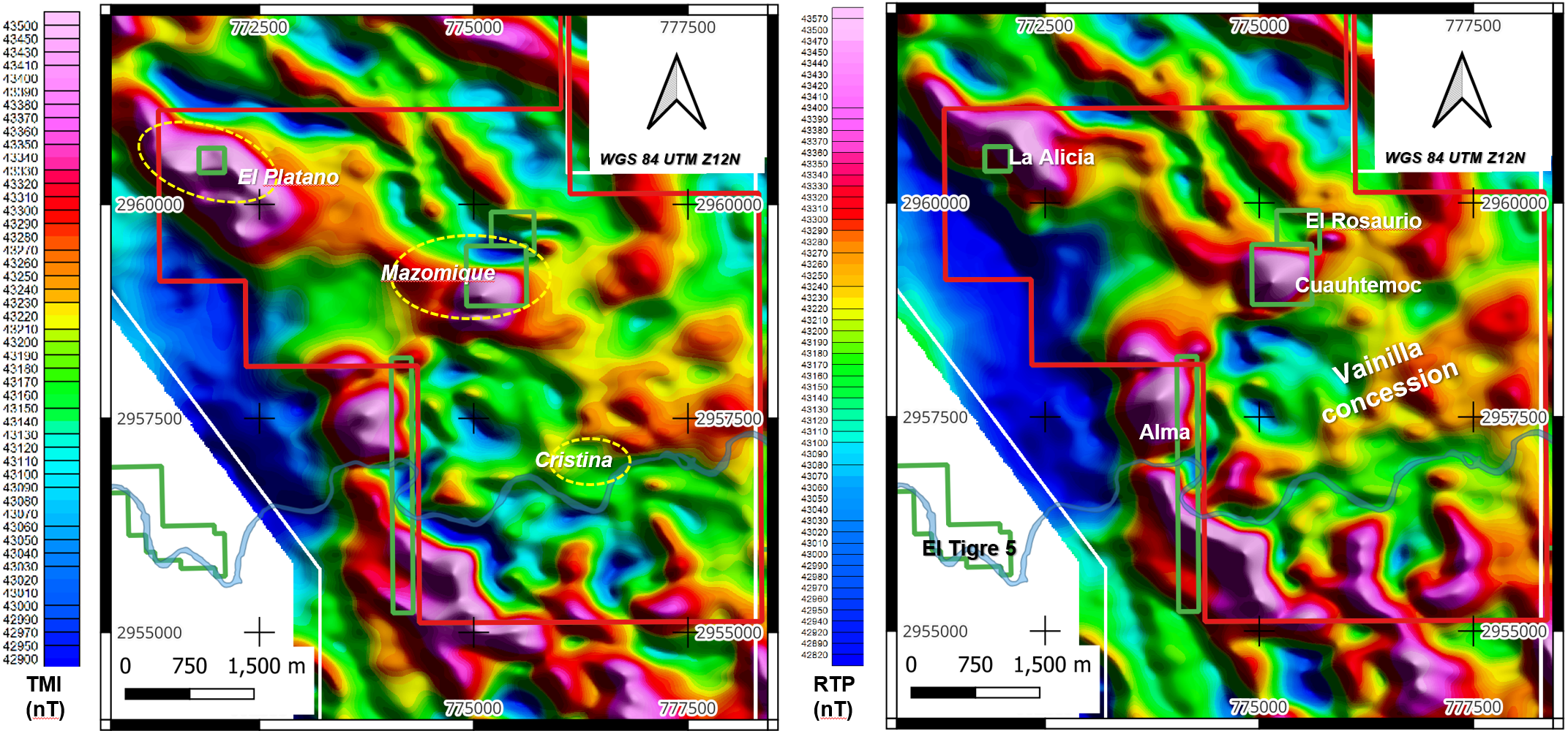
Figure 5: Airborne drone magnetometry results displaying levelled Total Magnetic Intensity (TMI, left pane) and Reduced to Pole TMI (RTP, right pane): coverage extends across the Vainilla Concession; images include the location of inset concessions and of the principal sampled prospects.
Next Steps
Oroco is integrating the magnetic results with its geological and geochemical database to prioritize follow-up mapping and sampling. The Company will also assess prospective structural intersections, intrusive contacts and magnetic anomaly margins as potential targets for further geophysical work and future drilling. Applications for drilling permits have been initiated, anticipating further positive results from more detailed mapping sampling and geophysical surveys.
Quality Assurance / Quality Control
Blank and low-grade copper standards (as utilized in the Santo Tomás resource drilling programs) with known low-grade gold and silver values were inserted into the sample consignment sent to ALS in Hermosillo. Higher grade copper and silver values returned are reliant upon laboratory standards for QA/QC and are to be treated as indicative exploration results and not as standards-controlled assays.
Qualified Person
Andrew Ware, RM-SME, a Qualified Person as defined in NI 43-101 — Standards of Disclosure for Mineral Projects, and a senior consulting geoscientist to the Company, has reviewed and approved the technical disclosures in this news release. The Company adheres to CIM Best Practices Guidelines in conducting, documenting, and reporting exploration activities.
About Santo Tomás
Oroco controls the Santo Tomás project, an advanced-stage porphyry copper project in Choix, Sinaloa, Mexico. Oroco holds a net 87.0% interest in the 1,173-hectare Core Concessions and an 80% interest in surrounding concessions at Santo Tomás. The Project was tested by historical drilling from 1968 to 1994 and by Oroco's Phase 1 program, which totaled 48,481 metres in 76 diamond drill holes and supported the revised Mineral Resource Estimate (“MRE”) and updated Preliminary Economic Assessment (“PEA”) filed in August 2024.
The August 2024 MRE, prepared by SRK Consulting (U.S.), Inc., outlined an Indicated Resource of 540.6 Mt at 0.33% Cu, 0.008% Mo, 0.028ppm Au and 2.1 ppm Ag and an Inferred Resource of 530.3 Mt at 0.31% Cu, 0.007% Mo, 0.023ppm Au and 1.9ppm Ag. The updated PEA, prepared by Ausenco Engineering USA South Inc., contemplates a staged open-pit operation ramping from 60,000 t/d in Year 1 to 120,000 t/d by Year 8 over a 22.6-year life of mine, generating an after-tax NPV₈% of US$1.48 billion and an after-tax IRR of 22.2%. Both studies are available at www.orocoresourcecorp.com and on SEDAR+ at www.sedarplus.ca.
The PEA is preliminary in nature, includes Inferred Mineral Resources that are considered too speculative geologically to have the economic considerations applied to them that would enable them to be categorized as Mineral Reserves, and there is no certainty that the results of the Preliminary Economic Assessment will be realized. Mineral Resources that are not Mineral Reserves do not have demonstrated economic viability. Market conditions, metal prices, costs, exchange rates, financing conditions, permitting requirements and other assumptions may have changed since the August 15, 2024 effective date.
About Oroco Resource Corp.
Oroco Resource Corp. is a Vancouver-based mineral exploration and development company advancing the Santo Tomás copper project in Sinaloa, Mexico.
For further information:
Charles (Charlie) Cryer, CEO
Oroco Resource Corp.
Tel: 604-688-6200 | info@orocoresourcecorp.com | www.orocoresourcecorp.com
Cautionary Note Regarding Forward-Looking Information
This news release contains forward-looking information within the meaning of applicable Canadian securities legislation, including statements regarding: the interpretation and significance of preliminary geological mapping, reconnaissance sampling and drone magnetic survey results at the Vainilla Project; the potential for Vainilla to host a cluster of porphyry-related, breccia and skarn mineralized centres; the possible extent, continuity and geological controls of mineralization at El Platano, Mazomique and Cristina; the potential significance of magnetic anomalies and intrusive and structural features; the integration of geological, geochemical and geophysical data; and the Company’s plans to undertake follow-up mapping, sampling, geophysical work, target development and future drilling.
Forward-looking information is based on management’s current expectations and assumptions, including assumptions regarding the accuracy and completeness of geological, geochemical, assay and geophysical data; the validity of preliminary geological and geophysical interpretations; the relationship, if any, between surface mineralization, magnetic responses and mineralization at depth; continued access to the property; the availability of personnel, contractors, laboratories and equipment; the Company’s ability to obtain any required permits and authorizations and to fund and complete planned exploration activities; and commodity prices and general market conditions.
Forward-looking information is subject to known and unknown risks, uncertainties and other factors that may cause actual results to differ materially from those expressed or implied, including the selective and non-representative nature of the reconnaissance rock samples; sampling, analytical and QA/QC uncertainty; the possibility that mineralization and magnetic anomalies are discontinuous, limited in extent or do not persist at depth; the possibility that preliminary interpretations may change with additional data; the risk that follow-up work may not identify drill-ready targets or result in the discovery or definition of a mineral resource; title, access, regulatory, permitting, environmental and community risks; contractor and laboratory availability; financing risk; commodity-price fluctuations; and general economic and political conditions. There has been insufficient exploration to define a mineral resource at the Vainilla Project, and it is uncertain whether further exploration will result in the definition of a mineral resource.
Readers are cautioned not to place undue reliance on forward-looking information. The Company does not undertake to update forward-looking information, except as required by applicable securities law.
Neither the TSX Venture Exchange nor its Regulation Services Provider accepts responsibility for the adequacy or accuracy of this news release.
Photos accompanying this announcement are available at:
https://www.globenewswire.com/NewsRoom/AttachmentNg/8d83377d-2696-4562-86e3-03566b4b5286
https://www.globenewswire.com/NewsRoom/AttachmentNg/34c7d157-6f87-4f1d-b4ba-d2b1f6802e7d
https://www.globenewswire.com/NewsRoom/AttachmentNg/dc76cf0b-5b67-4b4e-8e87-835be060724b
https://www.globenewswire.com/NewsRoom/AttachmentNg/e46e9c30-92b4-4d38-93d2-0c17bbe62683
https://www.globenewswire.com/NewsRoom/AttachmentNg/71243dd9-fd84-4140-b782-2192adb26945



Figure 1
Location of the Vainilla concession, northern Sinaloa (left pane); and in relation to the Santo Tomás and Bahuerachi porphyry copper occurrences and concessions (central pane). The locations of the El Platano, Mazomique and Cristina prospects are shown (right pane) in relation to Choix: note that the inset concessions which partially encompass the Mazomique Mine are not currently under option to Oroco.
Figure 2
Preliminary geological mapping and sampling on the Vainilla concession showing results for selected samples based upon threshold assays for Cu, Au, Ag and Pb.
Figure 3
a) Mineralized zone of the of El Platano breccia with high content of Cu-Fe oxides (sample 110803). b) Unmineralized breccia with jigsaw/mosaic texture cemented by quartz-tourmaline, El Platano. c) Prismatic quartz at the El Platano breccia pipe. d) Adit access at the Cristina prospect.
Figure 4
Field photographs from Mazomique prospect. Note the magnetite-sulfide-oxide replacement bodies in the left photograph (view looking NNW). Approximate height of darker magnetite skarn is 35 meters.
Figure 5
Airborne drone magnetometry results displaying levelled Total Magnetic Intensity (TMI, left pane) and Reduced to Pole TMI (RTP, right pane): coverage extends across the Vainilla Concession; images include the location of inset concessions and of the principal sampled prospects.
© 2026 Canjex Publishing Ltd. All rights reserved.