Toronto, Ontario--(Newsfile Corp. - June 16, 2026) - Powermax Minerals Inc. (CSE: PMAX) (OTCQB: PWMXF) (FSE: T23) (the "Company" or "Powermax") is pleased to announce the commencement of high-resolution helicopter-borne geophysical surveys and field exploration programs at its Pinard and Hopkins rare earth element ("REE") properties, located in Ontario.
The airborne surveys are being completed by Geo Data Solutions GDS Inc. ("GDS") and are designed to collect high-resolution magnetic, radiometric spectrometric and VLF-EM data over the Pinard and Hopkins properties. The surveys are intended to assist the Company in defining geological structures, lithological contacts, alteration patterns, radiometric anomalies and potential exploration targets prospective for REE mineralization.
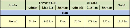
At the Pinard REE Property, the planned airborne survey comprises approximately 1,319 line-kilometres, including approximately 1,145 line-kilometres of traverse lines and 174 line-kilometres of tie lines. The traverse lines are planned at a nominal spacing of 50 metres, with tie lines at approximately 350 metres spacing.
Table 1: Pinard REE Property Survey Details
To view an enhanced version of this graphic, please visit:
https://images.newsfilecorp.com/files/11633/301516_26259814e4e66bf2_001full.jpg
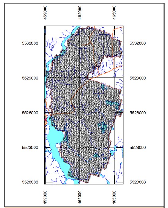
Figure 1: Planned Airborne Geophysical Survey Orientation - Pinard REE Property
(Source: Geo Data Solutions GDS Inc. survey specifications prepared for Powermax Minerals Inc.)
To view an enhanced version of this graphic, please visit:
https://images.newsfilecorp.com/files/11633/301516_26259814e4e66bf2_002full.jpg
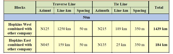
At the Hopkins REE Property, the planned airborne survey comprises approximately 1,623 line-kilometres, including approximately 1,409 line-kilometres of traverse lines and 214 line-kilometres of tie lines across the Hopkins West and Hopkins East survey blocks. Traverse lines are planned at a nominal spacing of 50 metres, with tie lines at approximately 350 metres spacing.
Table 2: Hopkins REE Property Survey Details
To view an enhanced version of this graphic, please visit:
https://images.newsfilecorp.com/files/11633/301516_26259814e4e66bf2_003full.jpg
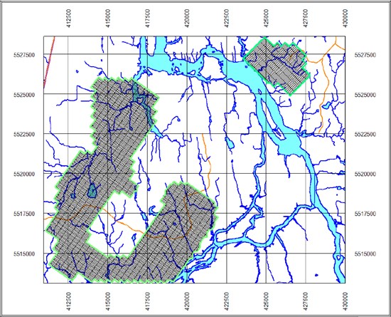
Figure 2: Planned Airborne Geophysical Survey Orientation - Hopkins REE Property
(Source: Geo Data Solutions GDS Inc. survey specifications prepared for Powermax Minerals Inc.)
To view an enhanced version of this graphic, please visit:
https://images.newsfilecorp.com/files/11633/301516_26259814e4e66bf2_004full.jpg
The airborne surveys are being flown using an Astar 350D helicopter or equivalent aircraft equipped with magnetic, radiometric spectrometric and VLF-EM systems. The surveys will be flown using GPS navigation and a planned 3D drape flight surface, subject to terrain, weather and aviation safety requirements. GDS will complete field quality-control monitoring during the surveys, including checks of flight-path positioning, aircraft altitude and speed, magnetic diurnal variations, radiometric system performance and VLF-EM signal quality.
The airborne survey data has not yet been fully processed or interpreted, and no exploration targets have been confirmed from the current program at this time. Results from the airborne surveys and field programs will be integrated with available geological information to prioritize areas for follow-up exploration.
In conjunction with the airborne geophysical programs, Powermax has also commenced field prospecting, geological mapping and sampling work at both the Pinard and Hopkins properties. The field programs are designed to follow up prospective geological trends, assess areas of radiometric and magnetic interest, identify favourable host rocks and structures, conduct radiometric surveys using handheld scintillometer, and collect rock, soil and other samples where warranted. Results from the airborne surveys and field programs will be integrated to prioritize targets for follow-up exploration.
"The commencement of airborne geophysics and field exploration at Pinard and Hopkins represents an important step in advancing our Ontario REE portfolio," said Paul Gorman, Chief Executive Officer of Powermax Minerals Inc. "The combination of high-resolution magnetic, radiometric and VLF-EM data with prospecting, mapping and sampling will provide Powermax with a strong technical foundation to refine targets and guide the next phase of exploration."
The Company expects to provide further updates as the airborne surveys and field programs progress and as data compilation, interpretation and analytical results become available.
Qualified Person
Afzaal Pirzada, P.Geo., a Director of the Company and a "Qualified Person" as defined by National Instrument 43-101, reviewed and approved the scientific and technical information disclosed in this press release.
About Powermax Minerals Inc.
Powermax Minerals Inc. is a Canadian mineral exploration company focused on advancing rare earth element projects. The Company holds options to acquire the Cameron REE Property in British Columbia and the Atikokan, Pinard and Hopkins REE properties in Ontario, and owns a 100% interest in the Ogden Bear Lodge REE project in Crook County, Wyoming.
Forward-Looking Statements
This news release contains forward-looking statements and forward-looking information within the meaning of applicable Canadian securities laws. Forward-looking statements include, but are not limited to, statements regarding the commencement, timing and completion of airborne geophysical surveys and field exploration programs; the expected benefits of the surveys and fieldwork; the ability of the Company to identify or prioritize exploration targets; and future exploration plans at the Pinard and Hopkins properties. The airborne survey data has not yet been fully processed or interpreted, and no exploration targets have been confirmed from the current survey program at this time.
Forward-looking statements are based on the Company's current expectations, estimates, forecasts and assumptions, and are subject to known and unknown risks, uncertainties and other factors that may cause actual results or events to differ materially from those expressed or implied by such forward-looking statements. These risks include, but are not limited to, exploration risks, weather and logistical risks, contractor availability, aviation safety considerations, permitting and regulatory matters, commodity market conditions, financing risks, and general economic conditions.
Readers are cautioned not to place undue reliance on forward-looking statements. The Company undertakes no obligation to update or revise any forward-looking statements except as required by applicable securities laws.

To view the source version of this press release, please visit https://www.newsfilecorp.com/release/301516

© 2026 Canjex Publishing Ltd. All rights reserved.