Vancouver, British Columbia--(Newsfile Corp. - September 16, 2026) - Spark Energy Minerals Inc. (CSE: SPRK) (OTC Pink: SPARF) (FSE: 8PC) ("Spark" or the "Company") announces that reconnaissance exploration focused on tungsten has commenced at its Seridó Project in Rio Grande do Norte, Brazil (the "Project"): twelve exploration permits covering 21,492.74 hectares (about 215 km²) in the district that has supplied most of Brazil's tungsten since the Second World War. Geologists are mapping the marble and calc-silicate horizons that host scheelite, the district's tungsten ore mineral, and sampling rock and stream sediment across five regional target areas (Figure 1). The Arapaima Project in Minas Gerais, which includes the Cruzeta and Boa Vista gallium and rare earth element discoveries, remains the Company's principal focus.
"Tungsten has become a strategic metal, and the world is looking for supply outside China," said Dr. Fernando Tallarico, Chief Executive Officer of Spark Energy Minerals Inc. "The Seridó district of Rio Grande do Norte has produced scheelite for more than eighty years and hosts the largest scheelite mine in South America. Spark secured 21,500 hectares on the rocks that host those mines before tungsten prices took off, and our geologists are now in the field. Tungsten adds a third critical mineral to Spark's portfolio, alongside gallium and rare earths at Arapaima, in a district with a proven record."
Highlights
Tungsten market context. About 60% of the metal goes into cemented carbides, the hard material in cutting, drilling, mining, and construction tools; the rest goes into specialty steels, turbine and armor alloys, electrical components, and chemicals. China mined roughly 79% of the world's supply in 2025 and has required export licenses since February 2025; prices rose about sixfold between January 2025 and April 2026, the largest increase among the selected critical minerals assessed by the International Energy Agency. (Source: IEA, Global Critical Minerals Outlook 2026, executive summary and pp. 22-23: https://iea.blob.core.windows.net/assets/19c60aa0-ee07-4a20-a138-33c967ac5008/GlobalCriticalMineralsOutlook2026.pdf). The United States has not mined tungsten since 2015.
Project location and exploration history. The Seridó has produced tungsten since the Second World War from scheelite in skarns. Spark's five regional target areas, granted in 2023 and 2024, sit beside the district's mines and cover the same rocks that host them (Figure 1). Prospectors found the district's mines at the surface; Spark's program is, to the Company's knowledge, the first systematic exploration of the Company's permits in the district using modern methods.
Regional public geochemical data. The highest of 1,888 government stream-sediment samples, 122.3 ppm tungsten, lies 1.6 km from the boundary of permit 848.204/2023, with scheelite in the panned concentrate at the same station (Figure 2); the densest anomaly field in the district lies immediately south-east of the permits (Figure 1). No earlier tungsten exploration is recorded on the permits themselves.
Work under way. Mapping, stream-sediment sampling and rock-chip sampling, with full QA/QC, over five corridor-scale targets defined from the regional airborne survey; samples will be analyzed for gold and bismuth as well as tungsten. First results are expected before year-end.
Gold and bismuth in the same district. Aura Minerals' Borborema Mine, 18 km from the Lagoa permits, declared commercial gold production in September 2025 on reserves of about 1.5 million ounces; the Bonfim Mine at Lajes, 28 km from the northern permits, is a gold-tungsten-bismuth skarn mine. Like tungsten, gold and bismuth are at multi-year highs.
Mineralization and the technical information reported for neighbouring properties are not necessarily indicative of mineralization on the Company's Seridó Project. The Company has no interest in those neighbouring properties.
Scheelite: Ore Mineralogy and Field Identification
Scheelite, calcium tungstate (CaWO₄), is 63.9% tungsten by weight (80.5% WO₃) and dense (specific gravity 5.9-6.1), which is why it concentrates by gravity. In daylight it is pale and easily overlooked; under short-wave ultraviolet light (254 nm) it fluoresces bright blue-white — yellow-white where molybdenum substitutes for tungsten. No other ore mineral in the district offers that test, so every rock and float sample is examined under an ultraviolet lamp at the field base, and scheelite is identified on the spot.
Reconnaissance Program
Fieldwork began in September 2026 to test whether the host horizons on the permits carry tungsten: mapping of the marble and calc-silicate horizons, their granite contacts and the northeast-trending structures that control the district's ore bodies; stream-sediment sampling around every target area; and rock-chip sampling of any scheelite occurrence, with full QA/QC and multi-element analysis, including gold and bismuth, at an accredited laboratory. Traverses follow five corridor-scale targets defined from the regional airborne magnetic and radiometric survey: two in the Bodó target area and one each in Lagoa, Acari and Cruzeta. Ground geophysics will follow on any target confirmed in the field, ahead of drill planning.
The Seridó Tungsten District
Second World War demand for tungsten opened the Brejuí Mine, near Currais Novos, in 1943. Brejuí is the largest scheelite mine in South America: it was worked without interruption until November 1997 — at full scale into the 1980s, then cut back under Chinese competition — restarted in 2006 on tailings and small-scale mining, and in 2025 produced about 15 t of scheelite concentrate a month. With Barra Verde, Boca de Laje, and Zangarelhas, it forms one ore body reported to have accounted for about 70% of the district's approximately 55,000 t of concentrate production between 1942 and 1982 (Table 1). The district is producing again: the state's tungsten exports rose 356% in the first half of 2026, at an average price four times that of the previous year. The Seridó is Brazil's tungsten province, and the permits sit on its host rocks beside the mines that define it. Table 1 sets out what public sources report for each mine.
Gold and Bismuth in the District
Borborema, an open pit east of Currais Novos, reports probable reserves of 40.7 Mt at 1.13 g/t gold — about 1.5 million ounces — for about 65,000 ounces a year over a 20-year mine life, with the ore body open along strike and at depth; Bonfim, at Lajes, is registered for gold, tungsten and bismuth ores (Table 1). Gold has traded above US$4,300 per ounce through early September 2026, about a fifth higher than a year earlier. Bismuth, used in pharmaceuticals, lead-free solders, alloys and pigments and about 88% refined in China, has been under Chinese export licensing since February 2025 and trades near US$67 per kilogram, about five times its 2023 level. The Company has not identified any gold or bismuth mineralization on its permits.
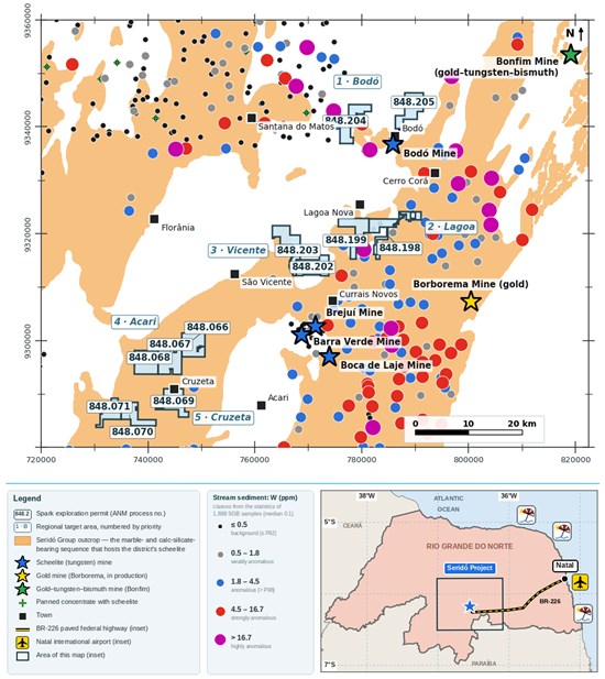
Figure 1. Seridó Project: Spark's twelve exploration permits (blue; ANM SIGMINE cadastral polygons, labelled by process number) in five regional target areas numbered by priority, the district's mines (stars at approximate locations: blue, scheelite; yellow, gold; green, gold-tungsten-bismuth), the mapped outcrop of the Seridó Group (orange; SGB-CPRM ARIM, extended east of 812,000 E from the SGB-CPRM 2022 simplified map), SGB-CPRM stream-sediment samples classified by the statistics of the 1,888 compiled analyses (see legend; stations on the Currais Novos sheet are classified from the SGB-CPRM 2023 map and carry no analytical values) and scheelite-bearing panned concentrates (green crosses). Inset: Rio Grande do Norte; Natal, the state capital, lies about 150 km east of the Project (180 km by the paved BR-226); its international airport has direct flights to Lisbon, Buenos Aires and Montevideo and connections to North America and across Brazil, and paved highways join the towns of the Project area. Mineralization at the mines (Table 1) is not necessarily indicative of mineralization on the Company's permits. Grid: UTM SIRGAS 2000 zone 24S (meters).
To view an enhanced version of this graphic, please visit:
https://images.newsfilecorp.com/files/10093/314437_21486aecd4d468d9_001full.jpg
Mine (municipality)
commodity | Operator | Status | Reported tonnage, grade and production | Source |
Brejuí
(Currais Novos)
tungsten | Mineração Tomaz Salustino S/A | Largest scheelite mine in South America. Opened in 1943; scaled down from the 1980s; closed in November 1997; producing again since 2006, about 15 t of concentrate a month in 2025 | One ore body with Barra Verde, Boca de Laje and Zangarelhas: about 70% of the district's 1942-1982 output of 55,000 t of concentrate at about 70% WO₃, from ore averaging 0.7-1% WO₃; 39% of Rio Grande do Norte's WO₃ reserves in 2009 (1,738 t contained), mostly at Brejuí | Maranhão et al. in CETEM 2009; DNPM 2009; Tribuna do Norte 2006, 2025 |
| Barra Verde (Currais Novos) tungsten | Mineração Barra Verde; assignee Mineração Currais Novos (Largo); lessee Acauan (2013) | Past hard-rock producer; tailings reprocessed by Largo 2011-2012 | Tailings, with Boca de Laje: 3.46 Mt indicated at 0.120% WO₃ + 0.81 Mt inferred at 0.093% (0.06% cut-off; 2010 PEA) | Largo 2010; ANM 2014 |
| Boca de Laje (Currais Novos) tungsten | Mineração Boca de Laje; lessee Acauan (2013) | Past hard-rock producer; tailings reprocessed with Barra Verde | Included with Barra Verde | Largo 2010; ANM 2014 |
| Zangarelhas (Currais Novos) tungsten | —
| Past producer; same ore body as Brejuí | Included in the Brejuí figures | CETEM 2009 |
| Bodó (Bodó) tungsten | Bodó Mineração, lessee of Metais do Seridó; restart advanced by Pure Tungsten Ltd. | Mined since the 1940s; producing in 2013; feed grade 1.44% WO₃ in 2016-2017 | 61% of Rio Grande do Norte's WO₃ reserves in 2009 (2,718 t contained) | DNPM 2009; ANM 2014; Pure Tungsten |
| Borborema (Currais Novos) gold | Aura Minerals Inc. | Open pit; commercial production declared September 2025; 26 km east of Currais Novos on BR-226 | Probable reserves 40.7 Mt at 1.13 g/t Au for about 1.48 Moz (S-K 1300, February 2026); about 65 koz a year over a 20-year mine life; ore body open along strike and down-dip | Aura 2025, 2026 |
Bonfim I and II (Lajes)
gold, tungsten, bismuth | Mineradora Nosso Senhor do Bonfim; permit registered for gold, tungsten and bismuth ores | Producing from a gold-tungsten-bismuth skarn (2013) | Reported targets of more than 0.3 Mt at 0.5-9% WO₃ (mean 4.8%) with gold; 20-30 t of WO₃ per month in 2013 | CPRM 2016; ANM 2014; ANM process 848.016/2016 |
| All scheelite mines, Rio Grande do Norte. | —
| —
| Reserves of 25,400 t of contained tungsten at 0.04-2.4% WO₃ (2013); 451 t of concentrate at 72% WO₃ produced in 2007, mostly from Brejuí and Bodó | ANM 2014; DNPM 2008 |
Table 1. Mines of the Seridó district as reported in public sources. The figures are historical and were reported by third parties or government agencies under Brazilian reporting categories, which are not CIM categories, except the Largo 2010 and Aura 2026 estimates, prepared under NI 43-101 and S-K 1300 respectively for those companies; the Company's Qualified Persons have verified none; none is treated as a current mineral resource or reserve, and none is necessarily indicative of mineralization on the Company's permits.
Land Position and Geological Setting
The twelve permits form five regional target areas — Bodó, Lagoa, Vicente, Acari and Cruzeta, in that order of priority — across the municipalities of Cerro Corá, Santana do Matos, Currais Novos, Acari, Cruzeta and Caicó (Table 2), and are held by Spark Energy Minerais do Brasil Ltda., the Company's wholly-owned subsidiary.
| ANM process | Regional target area (priority) | Municipality | Area (ha) | | Nearest scheelite mine (approx. distance from permit boundary) |
|---|
| 848.204/2023 | Bodó (1) | Santana do Matos | 1,828.28 | | Bodó ≈ 3 km |
| 848.205/2023 | Bodó (1) | Cerro Corá | 1,941.00 | | Bodó ≈ 3 km |
| 848.198/2023 | Lagoa (2) | Currais Novos | 1,881.52 | | Bodó ≈ 13 km; Brejuí ≈ 14 km |
| 848.199/2023 | Lagoa (2) | Currais Novos | 1,711.42 | | Bodó ≈ 13 km; Brejuí ≈ 14 km |
| 848.202/2023 | Vicente (3) | Currais Novos | 1,920.72 | | Brejuí ≈ 10 km |
| 848.203/2023 | Vicente (3) | Currais Novos | 1,975.80 | | Brejuí ≈ 10 km |
| 848.066/2023 | Acari (4) | Acari | 1,895.60 | | Barra Verde ≈ 18 km |
| 848.067/2023 | Acari (4) | Cruzeta | 1,957.83 | | Barra Verde ≈ 18 km |
| 848.068/2023 | Acari (4) | Cruzeta | 1,957.79 | | Barra Verde ≈ 18 km |
| 848.069/2023 | Cruzeta (5) | Cruzeta | 1,737.11 | | Barra Verde ≈ 24 km |
| 848.070/2023 | Cruzeta (5) | Cruzeta | 1,529.21 | | Barra Verde ≈ 24 km |
| 848.071/2023 | Cruzeta (5) | Caicó | 1,156.46 | | Barra Verde ≈ 24 km |
| Total | 12 permits
5 target areas |
| 21,492.74 | | ≈ 215 km² |
Table 2. Seridó Project exploration permits. Areas and municipalities as registered in the ANM cadastre; the regional target areas are the Company's working names, numbered by exploration priority (1 = highest). Distances are from the nearest boundary of the target area's cadastral polygons to the approximate mine location in the Company's GIS, rounded to the kilometer.
The Seridó Group, which carries the marble and calc-silicate horizons that host all of the district's scheelite, crops out in northeast-trending belts (Figure 1). Acari lies entirely within the outcrop, and Cruzeta lies within the outcrop for about 60% of its area; Lagoa and Vicente straddle the contact with the basement, where the district's skarns occur; Bodó lies on basement 3 km from the Bodó Mine. Based on host rock, structure, proximity to the mines, and the public record, the Company's Qualified Persons consider all five target areas highly prospective for skarn-hosted scheelite. Prospectivity is not mineralization: no mineralization has yet been identified on the permits, and the program is designed to test for it.
Public Geochemical Data and Anomaly Thresholds
The Company compiled the Geological Survey of Brazil (Serviço Geológico do Brasil, "SGB-CPRM") stream-sediment and panned-concentrate surveys on seven 1:100,000 sheets, the SGB-CPRM 2023 district-wide stream-sediment map, the SGB-CPRM regional airborne survey (Project 1092), and SGB-CPRM geological mapping. Of the 1,888 stream-sediment samples, 57% are below the 0.1 ppm detection limit, and the median is 0.1 ppm; the 92nd, 98th, and 99th percentiles are 0.5, 1.8, and 4.5 ppm. The Company therefore classifies values up to 0.5 ppm as background, 0.5-1.8 ppm as weakly anomalous, 1.8-4.5 ppm as anomalous (21 samples), 4.5-16.7 ppm as strongly anomalous (12 samples), and above 16.7 ppm as highly anomalous (8 samples) — the same intervals SGB-CPRM used on its 2023 district map, which places the sheets not yet compiled on the same scale (Figure 1). Scheelite is recorded in 301 of the 1,595 SGB-CPRM panned concentrates. Table 3 summarizes the public data around each regional target area.
| Regional target area (priority) | Public stream-sediment stations within 5 km of the permit boundary | Of which anomalous or higher
(> 1.8 ppm W) | Highest tungsten value within 5 km | Nearest station to the permit boundary |
| 1 Bodó | 16 | 4 | 122.3
(compiled analysis) | inside the permits |
| 2 Lagoa | 21 | 13 | 16.7-26 ppm class
(SGB map) | inside the permits |
| 3 Vicente | 5 | 3 | 4.5-16.7 ppm class
(SGB map) | 2.3 km |
| 4 Acari | 1 | 1 | 1.8-4.5 ppm class
(SGB map) | 3.2 km |
| 5 Cruzeta | 2 | 2 | 1.8-4.5 ppm class
(SGB map) | 1.9 km |
Table 3. Public stream-sediment stations within a 5 km radius of the outer boundary of each regional target area's permits, listed by priority, counting both the SGB-CPRM samples with compiled analytical values and the stations of the SGB-CPRM 2023 district map, which carry a class but no value. "Anomalous or higher" means above 1.8 ppm tungsten, the 98th percentile of the compiled data. Where the highest station within 5 km has no compiled value, its class on the SGB-CPRM map is given. "Inside the permits" means that at least one station falls within a permit; no station with a compiled value does. Distances are measured from the nearest permit boundary of the target area.
Bodó — first priority. The 122.3 ppm sample (station 4212-DC-S-0503), the highest tungsten value of the 1,888 compiled analyses, lies 1.6 km west-north-west of the boundary of permit 848.204/2023, with scheelite in its panned concentrate; three further strongly or highly anomalous samples (24.9 and 19.7 ppm at one station, 22.1 and 13.4 ppm) lie within 15 km to the west and north-west. The nearest public sample to any permit, 0.6 km from the same boundary, returned 2.7 ppm. South-east of the permit, on the Currais Novos sheet, the SGB-CPRM 2023 map shows a station in its 16.7-26 ppm class 3.3 km from the boundary and 4 km west of the Bodó Mine, and one in its 4.5-16.7 ppm class 1.8 km from the boundary; their analytical values are not yet compiled (Figure 2). Based on these results, the Bodó target area, and permit 848.204/2023 within it, is the Company's first priority.
Lagoa — second priority. Permits 848.198/2023 and 848.199/2023 sit on the contact of the Seridó Group with the basement, where the SGB-CPRM district map shows 21 stations within 5 km of the permits, 13 of them anomalous or higher — the densest anomaly field beside any Company permit — including one in the 16.7-26 ppm class 1.3 km from permit 848.199/2023, in the belt that continues south to the Brejuí and Barra Verde Mines 14 km away (Figure 1). The analytical data for the Currais Novos sheet are being compiled. Based on the density and continuity of these anomalies, Lagoa is the Company's second priority; Vicente, Acari, and Cruzeta follow in that order.
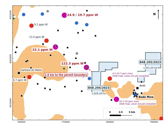
Figure 2. Bodó regional target area (first priority): permits 848.204/2023 and 848.205/2023 (blue) with the SGB-CPRM stream-sediment samples of the Açu sheet, classified and coloured as in Figure 1; strongly and highly anomalous samples (red and magenta) are labeled with their tungsten values. The two stations south-east of permit 848.204/2023 belong to the Currais Novos sheet and are labeled with their class on the SGB-CPRM 2023 map; their analytical values have not yet been compiled. The 122.3 ppm sample, the highest of the 1,888 compiled analyses, lies 1.6 km west-north-west of the boundary of permit 848.204/2023, and scheelite was recorded in the panned concentrate at the same station (green cross). Seridó Group outcrop in orange; Bodó Mine and towns as in Figure 1. Grid: UTM SIRGAS 2000 zone 24S (meters).
To view an enhanced version of this graphic, please visit:
https://images.newsfilecorp.com/files/10093/314437_21486aecd4d468d9_002full.jpg
Project Naming
The district is known as both the Seridó and, after its main town, the Currais Novos tungsten district; the Company uses Seridó throughout, and the permits it previously called the Currais Novos Project are now the Seridó Project. It is unrelated to Largo Inc.'s Currais Novos Tungsten Project, the Barra Verde and Boca de Laje tailings, in which the Company has no interest.
Data Sources and Verification
The geochemical data in this release were collected and analyzed by SGB-CPRM under its Seridó Mineral Province programs and published as open data; the airborne data were acquired for SGB-CPRM under Project 1092; mine information is from SGB-CPRM publications, ANM and DNPM mineral summaries and the ANM cadastre, Largo Inc., Aura Minerals Inc. and Pure Tungsten Ltd. disclosure, and other public records; commodity figures are from the U.S. Geological Survey, the International Energy Agency and published market prices as of early September 2026. Permit outlines are the cadastral polygons of the ANM SIGMINE register, whose computed areas agree with the registered areas within 0.2%. The Seridó Group outline in Figure 1 is the SGB-CPRM ARIM Seridó outcrop as compiled in the Company's GIS, extended east of 812,000 E from the SGB-CPRM 2022 simplified geological map of the Borborema Pegmatite Province; the Currais Novos-sheet stream-sediment stations and their classes are reproduced from the SGB-CPRM 2023 map and are positioned to about 200 m; below-detection values (57% of samples) are treated as 0.1 ppm; mine locations are approximate. The Company's Qualified Persons have reviewed the compilation for internal consistency — coordinates, units, duplicate stations, the point-in-polygon test of every public station against the cadastral polygons and the reconciliation of permit areas to the ANM register — and consider the public datasets adequate for the purpose of this disclosure. They have not independently verified the underlying historical samples, analyses or survey data. Mapping and sampling under the Company's reconnaissance program are underway, but no samples have yet been submitted to the laboratory and no assay results from that program are available as of the date of this release. Most of the public sampling data relate to locations outside the Company's permits, with exceptions identified in Table 3. These historical samples were collected by SGB-CPRM, not by Spark, and are not necessarily indicative of mineralization on the Project.
Cautionary Statement Regarding Historical Mines and Neighboring Properties
The Brejuí, Barra Verde, Bodó, Boca de Laje, Borborema and Bonfim Mines, and the Currais Novos Tungsten Project of Largo Inc. are held by third parties in which the Company has no interest. Mineralization on neighboring properties is not necessarily indicative of mineralization on the Company's permits. The reserve, resource, tailings, grade and production figures quoted for those mines in Table 1 are historical, were reported by third parties or government agencies, have not been verified by the Company's Qualified Persons, and are not being treated by the Company as current mineral resources or mineral reserves.
Exploration-Stage Property; No Mineral Resource or Economic Analysis
The Seridó Project is an exploration-stage property. The Company has not identified tungsten, gold or bismuth mineralization on the permits. The Company has not estimated any mineral resource or mineral reserve for the Project, and it has not completed a preliminary economic assessment, pre-feasibility study, feasibility study, or other economic analysis. The reconnaissance program may not identify mineralization, and any mineralization identified may not prove economically or technically viable to extract. The target areas described in this release derive from regional geophysical interpretation. Reconnaissance mapping and sampling are underway, but no assay results are available and the target areas have not been tested by drilling; references to prospectivity reflect the Company's current geological interpretation only.
Qualified Persons
The scientific and technical information in this news release has been reviewed and approved by Jonathan Victor Hill, BSc (Hons), FAusIMM, VP Exploration, Country Manager & Director of the Company, and Dr. Fernando Tallarico, P.Geo., FSEG, Chief Executive Officer & Chairman of the Company, each a Qualified Person as defined by National Instrument 43-101 — Standards of Disclosure for Mineral Projects. Neither Qualified Person is independent of the Company.
About Spark Energy Minerals Inc.
Spark Energy Minerals Inc. is a Canadian critical minerals exploration company whose principal asset, the Arapaima Project, comprises approximately 91,900 hectares across several municipalities in the Lithium Valley region of Minas Gerais, Brazil. The Company has made gallium and rare earth element discoveries at Cruzeta and, more recently, at Boa Vista, where mineralization is hosted in ionic adsorption clays developed over the Caladão Granite. Lithium-bearing pegmatites are a secondary target on the property. The Company also holds the Seridó Project, comprising twelve exploration permits totaling 21,492.74 hectares in the Seridó tungsten district of Rio Grande do Norte, where tungsten-focused reconnaissance exploration is underway.
Forward-Looking Statements
This news release contains "forward-looking statements" and "forward-looking information" (collectively, "forward-looking information") within the meaning of applicable Canadian securities laws, including National Instrument 51-102 Continuous Disclosure Obligations, and the United States Private Securities Litigation Reform Act of 1995. Forward-looking information includes, without limitation, statements regarding: the Company's exploration strategy and objectives for the Seridó Project, including its objective of establishing whether the Project can become a source of tungsten for supply chains outside China; the scope, timing, methods, budget, permitting and results of the reconnaissance program and any subsequent geophysical surveys, sampling or drilling; the interpretation and significance of public-domain geochemical, geophysical, geological and historical mining data, including statements about host rocks, lithological control, dispersion patterns, target areas, the ranking of the regional target areas and the prospectivity of the permits; the timing of first results and of the compilation of further public data; the potential for gold and bismuth in the district or on the permits; the availability of additional public data, personnel, contractors and laboratories; the Company's title to the permits, including the registration of permit assignments, the extension of exploration terms and the addition of substances to the permits; the renaming of the Project; tungsten, gold and bismuth market conditions, prices, demand, export controls and critical-mineral policies; the potential for discovery of tungsten or other mineralization on the Project; the advancement of the Arapaima Project; the availability of financing; and the Company's plans, objectives, expectations and strategies. Forward-looking information is identified by words such as "may," "could," "would," "will," "expect," "anticipate," "believe," "intend," "plan," "estimate," "project," "potential," "target," "objective," "prospective," "priority," or similar expressions, including negative and grammatical variations of them.
Forward-looking information is based on assumptions management considers reasonable as of the date of this news release, including assumptions regarding: the accuracy, completeness and reliability of public-domain data published by SGB-CPRM, the ANM, the U.S. Geological Survey, the International Energy Agency, other public bodies and third-party companies, none of which the Company has independently verified; the validity and good standing of the permits and the Company's ability to satisfy their work, reporting and fee obligations and to obtain any required amendments, extensions and registrations from the ANM in a timely manner; geological interpretations derived from regional, low-resolution data; the availability of personnel, contractors, laboratories and field access, including seasonal conditions; commodity prices and market and trade conditions, including critical-mineral export-control and trade policy in China and elsewhere; foreign exchange rates; the availability of financing on acceptable terms; and the ability to obtain and maintain tenure, environmental and other permits, community support and regulatory approvals in Brazil.
Forward-looking information is subject to known and unknown risks, uncertainties and other factors that may cause actual results, performance or achievements to differ materially from those expressed or implied, including, without limitation: the inherently preliminary and uncertain nature of mineral exploration; the risk that public-domain data are inaccurate, incomplete, of mixed vintage or method, or not representative of the Company's permits, and that regional data collected outside the permits do not indicate mineralization on them; the risk that the stream-sediment anomalies referred to in this release are sourced from ground outside the Company's permits; the risk that the target areas and host horizons do not carry tungsten, gold or bismuth mineralization, or that any mineralization identified is too small, too low in grade or too deep to be economic; the risk that airborne geophysical data cannot resolve, and ground surveys do not confirm, scheelite-bearing bodies; the risk that the Company's plans, timing or budget for the field program change or are not financed; the risk that amendments, extensions or registrations affecting the permits are delayed, refused or approved on conditions, that the Company fails to meet permit obligations, or that permits expire, are reduced or are challenged; competition for exploration ground, personnel and services in the district, including from larger and better-financed companies; the absence of any mineral resource or mineral reserve estimate and the risk that no economically viable deposit is ever defined; the risk that no metallurgical recovery of tungsten, gold or bismuth is demonstrated; volatility in tungsten, gold, bismuth and other commodity prices and in critical-mineral trade and export-control policy, including the risk that prices fall if export controls are relaxed or new supply enters the market; foreign exchange, inflation and cost risk; financing, dilution and liquidity risk; and title, permitting, regulatory, environmental, social, community, health and safety, and political risks associated with operating in Brazil. This list is not exhaustive. Additional risk factors are described in the Company's management's discussion and analysis and other continuous disclosure documents filed under its profile on SEDAR+ at www.sedarplus.ca.
Statements regarding exploration results, mineralization, prospectivity and geological interpretations are not, and must not be construed as, statements regarding the existence of any mineral resource, mineral reserve or commercially mineable deposit. There can be no assurance that any exploration program will result in a mineral discovery or that any mineralization identified will be developed into a commercially viable deposit. Readers are cautioned not to place undue reliance on forward-looking information. The forward-looking information in this news release is made as of the date hereof, and the Company does not undertake any obligation to update or revise it, whether as a result of new information, future events or otherwise, except as required by applicable securities laws.
Cautionary Note to United States Investors
This news release uses the terms "mineral resource", "indicated mineral resource", "inferred mineral resource", "mineral reserve" and "probable mineral reserve" in describing properties held by third parties. Where those figures were prepared under National Instrument 43-101 and the CIM Definition Standards, they are defined differently from, and may not be comparable to, the definitions adopted by the United States Securities and Exchange Commission in subpart 1300 of Regulation S-K; where they were prepared under subpart 1300, they are the third party's figures under that regime. Inferred mineral resources have a great amount of uncertainty as to their existence and economic and legal feasibility, and it cannot be assumed that all or any part of an inferred mineral resource will ever be upgraded to a higher category. No mineral resource or mineral reserve of any category has been estimated on the Company's properties. United States investors are cautioned not to assume that any part of the third-party figures quoted in this news release is economically or legally mineable.
This news release includes information obtained from public sources, including SGB-CPRM, the ANM, the U.S. Geological Survey, the International Energy Agency, published market prices and Rio Grande do Norte state trade statistics, and information regarding mineral properties and mines held by third parties, including Largo Inc., Aura Minerals Inc. and Pure Tungsten Ltd. The Company believes these sources to be reliable but has not independently verified the information and makes no representation as to its accuracy or completeness.
Neither the Canadian Securities Exchange nor its Market Regulator (as that term is defined in the policies of the Canadian Securities Exchange) accepts responsibility for the adequacy or accuracy of this release.

To view the source version of this press release, please visit https://www.newsfilecorp.com/release/314437

© 2026 Canjex Publishing Ltd. All rights reserved.