Vancouver, British Columbia--(Newsfile Corp. - September 10, 2026) - Toogood Gold Corp. (TSXV: TGC) (OTCQB: TGGCF) (FSE: D3P) ("Toogood" or the "Company") announces the definition of two priority, multi-kilometre drill-target corridors, the Widowmaker and Pacifico trends, following completion of 1:5,000-scale geological mapping at its Table Mountain Gold-Silver Project ("Table Mountain" or the "Project") in Lincoln County, Nevada.
Highlights
- Phase 1 mapping completed: Detailed 1:5,000-scale mapping has refined the volcanic stratigraphy, hydrothermal alteration, structural framework and epithermal veining across the Project;
- Widowmaker trend defined over more than 5 km: A major arcuate structural corridor extending through the core of the epithermal system and hosting a metre-scale epithermal vein intermittently exposed over more than 1 km, with associated float extending along a trend of more than 2 km;
- Pacifico trend defined over more than 5 km: A subparallel arcuate structural corridor located approximately 500 m east of Widowmaker and comprising multiple prospective faults hosting epithermal veins;
- Multiple priority drill targets identified: Kilometre-scale bends, stepovers, jogs and structural intersections define high-priority areas for drill testing;
- Evidence of boiling and system preservation: Vein and silica textures indicate widespread boiling and suggest that the prospective gold-silver interval may be preserved at depth;
- Exploration advancing: Field acquisition for UAV magnetics and ground gravity, together with soil and rock sampling, has been completed, with a 15 line-kilometre CSAMT survey scheduled for September; and
- Drill permitting initiated: Notice of Intent ("NOI") work is underway in support of the Company's planned maiden drill program.
Management Commentary
"We are increasingly encouraged by the structural architecture emerging at Table Mountain," stated Lee Hess, VP of Exploration. "Our work continues to define a large, well-preserved epithermal system characterized by laterally extensive, interconnected structural corridors that we believe provided important pathways for hydrothermal fluid flow. The scale and continuity of these structures, together with the intensity of alteration observed across the property, highlight the potential for a significant mineralizing system at depth. From a structural geology perspective, Table Mountain has many of the characteristics we look for when evaluating large-scale, low-sulphidation epithermal gold-silver systems, and we are excited to advance these corridors toward drill testing."
"Completion of Phase 1 mapping has significantly advanced our understanding of Table Mountain and established Widowmaker and Pacifico as the Project's two highest-priority drill-target corridors," stated Colin Smith, CEO and Director. "Both trends combine complex fault architecture, multiple epithermal veins and widespread evidence of boiling within a well-preserved epithermal system. With drill permitting underway, we are integrating the pending analytical and geophysical results to refine targets and advance Table Mountain toward its maiden drill program."
Geological and Structural Mapping
The Company has completed 1:5,000-scale geological and structural mapping across Table Mountain. The program refined the volcanic stratigraphy and distribution of hydrothermal alteration, epithermal veins, hydrothermal breccias and major structures across the Project (Figure 1).
Table Mountain is comprised predominantly of well-preserved, generally sub-horizontal Early Miocene poorly welded rhyolitic tuffs, intensely welded flows and intrusive rocks overlying older Oligocene rocks of the Indian Peak Caldera Complex. A fluvial, volcano-fanglomerate unit gradationally overlies the explosive tuff sequence and may record breaching of a caldera lake and a rapid change in the paleo-water table. The sub-horizontal stratigraphy suggests that the epithermal system has experienced limited post-mineral fault displacement and block rotation. Local offsets are observed in the southern Project area, where major northeast-trending structural corridors down-drop the volcanic sequence toward the southeast.
Epithermal quartz veins, hydrothermal breccias, chalcedonic blankets and recrystallized opaline silica occur along structures and lithological contacts throughout Table Mountain. These features occur within a coherent, approximately 4 km by 2 km hydrothermal alteration footprint previously defined by hyperspectral surveying.
Mapping identified two principal subparallel, arcuate structural corridors, Widowmaker and Pacifico, which together comprise more than 10 km of cumulative prospective strike. A hydrothermal breccia unit, mapped over approximately 2 km of strike, is spatially bounded by the two corridors (Figure 1; unit Tsbx). The rhyolitic protolith is pervasively silicified and brecciated, contains widespread lattice quartz textures, and is locally crosscut by chalcedonic veins. Together, these features record multiple phases of hydrothermal fluid flow, brecciation and silica sealing (Figure 3).
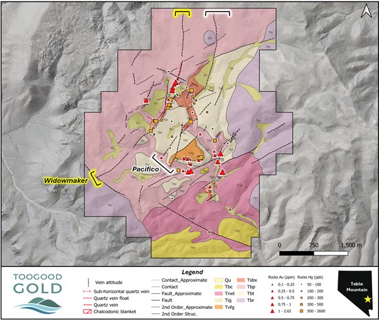
Figure 1: 1:5,000-scale geological and structural map of Table Mountain showing faults, volcanic stratigraphy, epithermal veins, and 2025 Orogen rock-sample gold and mercury values.
To view an enhanced version of this graphic, please visit:
https://images.newsfilecorp.com/files/11439/313777_008f137634e908ec_002full.jpg
Widowmaker Trend
Widowmaker is an arcuate structural corridor extending for more than 5 km through the core of the epithermal system. A metre-scale epithermal quartz vein, dipping 75° to 85° west-northwest, is intermittently exposed over more than 1 km. Vein float indicates a potential strike extent of more than 2 km. Mapping also identified additional banded quartz veins, pervasive silicification and hydrothermal brecciation along the corridor (Figure 2).
Multiple flexures, jogs and structural intersections occur along Widowmaker, including an approximately 3 to 4 m wide northwest-trending quartz vein intersecting the southwestern portion of the corridor (Figure 2, Photo 6). These areas of structural complexity may have enhanced permeability and represent priority targets for drill testing.
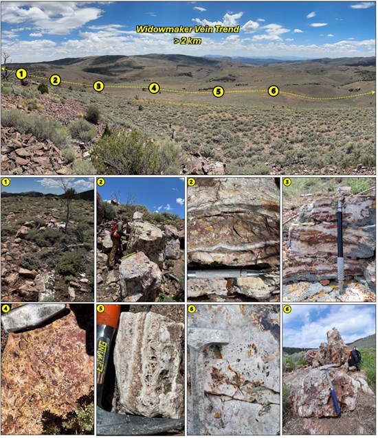
Figure 2: Panoramic view and representative field photographs along the Widowmaker trend, showing vein outcrop and float (1 to 3), pervasively silicified tuff (4), lattice and crustiform-colloform vein textures (5), and a 3 to 4 m wide crosscutting quartz vein defining a priority structural intersection target (6).
To view an enhanced version of this graphic, please visit:
https://images.newsfilecorp.com/files/11439/313777_008f137634e908ec_003full.jpg
Pacifico Trend
Pacifico is a subparallel arcuate structural corridor located approximately 500 m east of Widowmaker (Figure 1). The corridor comprises more than 5 km of cumulative mapped fault trace and hosts multiple structurally controlled, banded epithermal quartz veins. Pervasive silicification and localized steam-heated alteration occur along the corridor.
The spatial association of veining, alteration, hydrothermal breccias, structural complexity and historical gold and mercury anomalies defines multiple priority areas for CSAMT coverage and continued drill-target refinement.
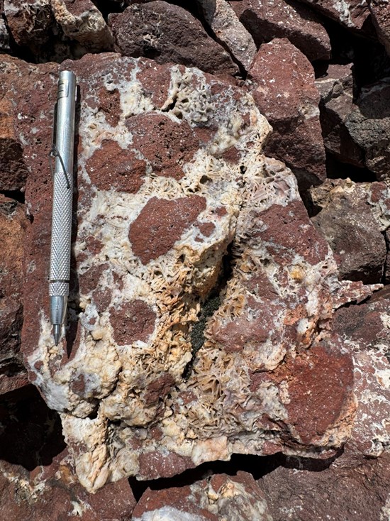
Figure 3: Hydrothermal breccia (unit Tsbx) comprising silicified rhyolitic clasts within a quartz-rich matrix containing abundant lattice-bladed quartz textures, recording repeated brecciation and silica sealing.
To view an enhanced version of this graphic, please visit:
https://images.newsfilecorp.com/files/11439/313777_008f137634e908ec_004full.jpg
Next Steps
Toogood's near-term work program at Table Mountain will include approximately 15 line-kilometres of controlled-source audio-frequency magnetotelluric ("CSAMT") surveying by Zonge International across priority target areas along the Widowmaker and Pacifico corridors (Figure 4).
CSAMT is designed to image subsurface electrical-resistivity contrasts potentially associated with major structures, silicification, alteration and hydrothermal fluid pathways. The survey will help evaluate the geometry and continuity of mapped structures and alteration beneath areas of limited exposure, providing an additional dataset for refining priority drill targets.
The Company will also receive, compile and interpret all pending soil and rock assay results and final processed ground-gravity and UAV-magnetic products. These datasets will be integrated with the completed geological mapping and LiDAR to rank and refine priority drill targets and develop drill sections across the Table Mountain epithermal system.
In parallel, SWCA Environmental Consultants has been engaged to advance the NOI process for the Company's planned maiden drill program.
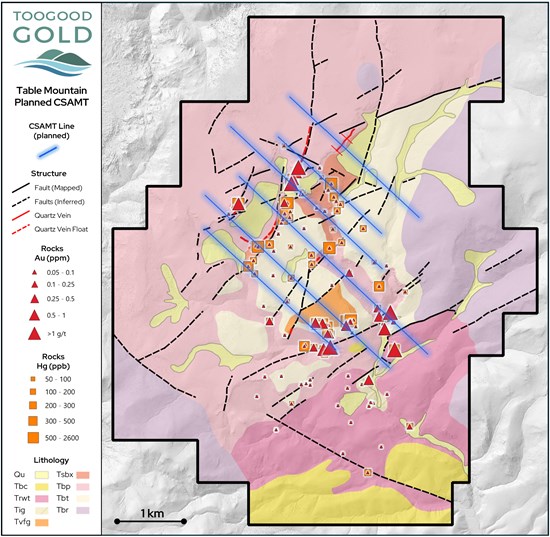
Figure 4: Planned CSAMT survey lines (blue), comprising approximately 15 line-kilometres across priority vein-bearing structures and 2025 Orogen rock-sample gold and mercury anomalies along the Widowmaker and Pacifico corridors.
To view an enhanced version of this graphic, please visit:
https://images.newsfilecorp.com/files/11439/313777_008f137634e908ec_005full.jpg
Historical Rock Sampling and Analytical Methods
The rock-sample gold and mercury values shown in Figures 1 and 4 are from first-pass reconnaissance sampling completed by Orogen Royalties in 2025 and were previously disclosed by the Company on March 2, 2026. Samples were selective or grab in nature and are not necessarily representative of overall grade or true width. Samples were analyzed by ALS Geochemistry using Au-ICP21 (30-gram fire assay with ICP-AES finish) and multi-element methods Hg-MS42 and ME-MS61. Sample preparation was completed at ALS Reno, with analyses completed at ALS Vancouver. Orogen's reconnaissance program did not include the insertion of certified reference materials, blanks or field duplicates; accordingly, the results should be considered preliminary. The Company is independently verifying these results through its 2026 rock-sampling program, for which assays remain pending.
Qualified Person
Colin Smith, M.Sc., P.Geo., a Qualified Person under National Instrument 43-101, has reviewed and approved the technical information contained in this news release. Mr. Smith is not independent of the Company, as he serves as its CEO and Director and owns securities of the Company.
About Toogood Gold Corp.
Toogood Gold Corp. is a Canadian exploration company focused on the discovery and advancement of high-grade gold systems in tier-one mining jurisdictions. The Company has two core areas of focus: the Table Mountain Project in Nevada, where the Company has an option to earn a 100% interest in a large, undrilled low-sulphidation epithermal system with extensive surface alteration and multiple mineralized vein exposures; and the district-scale Toogood Gold Project in Newfoundland, where the Company has an option to earn a 100% interest in a 164 km² land package covering a highly underexplored gold district with multiple target areas and demonstrated gold prospectivity.
Additional information about Toogood Gold Corp. can be found at www.sedarplus.ca.
Forward-Looking Information
This press release contains "forward-looking information" within the meaning of applicable Canadian securities legislation. Generally, forward looking information can be identified by the use of forward looking terminology such as "plans", "expects" or "does not expect", "is expected", "budget", "scheduled", "estimates", "forecasts", "intends", "anticipates" or "does not anticipate", or "believes", or variations of such words and phrases or state that certain acts, events or results "may", "could", "would", "might" or "will be taken", "occur" or "be achieved".
Forward-looking statements or information are subject to a variety of known and unknown risks, uncertainties and other factors that could cause actual events or results to differ from those reflected in the forward-looking statements or information, including, without limitation, the need for additional capital by the Company through financings, and the risk that such funds may not be raised; the speculative nature of exploration and the stages of the Company's properties; the effect of changes in commodity prices; regulatory risks that development of the Company's material properties will not be acceptable for social, environmental or other reasons; availability of equipment (including drills) and personnel to carry out work programs; and that each stage of work will be completed within expected time frames. This list is not exhaustive of the factors that may affect any of the Company's forward-looking statements or information. Although the Company has attempted to identify important factors that could cause actual results to differ materially, there may be other factors that cause results not to be as anticipated, estimated, described or intended. Accordingly, readers should not place undue reliance on forward-looking statements or information.
The Company's forward-looking statements and information are based on the assumptions, beliefs, expectations and opinions of management as of the date of this news release, and other than as required by applicable securities laws, the Company does not assume any obligation to update forward-looking statements and information if circumstances or management's assumptions, beliefs, expectations or opinions should change, or changes in any other events affecting such statements or information.
Neither TSX Venture Exchange nor its Regulation Services Provider (as that term is defined in the policies of TSX Venture Exchange) accepts responsibility for the adequacy or accuracy of this release.

To view the source version of this press release, please visit https://www.newsfilecorp.com/release/313777

© 2026 Canjex Publishing Ltd. All rights reserved.