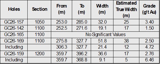
Vancouver, British Columbia--(Newsfile Corp. - July 14, 2026) - West Point Gold Corp. (TSXV: WPG) (OTCQX: WPGCF) (FSE: LRA0) ("West Point Gold" or the "Company") is pleased to announce the results from five drill holes within the high-grade Northeast ("NE") Tyro zone at its flagship Gold Chain Project in Arizona. Hole GC26-169 was a reverse circulation ("RC") hole that intersected 51.9 metres ("m") of 2.5 grams per tonne ("g/t") gold ("Au") from 276m, including 21.4m at 4.72 g/t. This intercept has an estimated true width ("TW") of 38m. These holes continue to extend the zone at NE Tyro down-dip where it remains open to depth and to the northeast towards the prospective Frisco Graben target.
The Company is reporting assay results for five drill holes (1,542m), GC26-142, GC26-157, GC26-159, GC26-165 and GC26-169. Results from 14 holes representing 4,378m of the recently completed 21,079m program are still pending. All results from Tyro Main and NE Tyro are expected to contribute to the Company's upcoming maiden resource estimate to be released later in 2026.
Highlights:
- Hole GC26-169 (Line 1100) intersected 51.9m at 2.5 g/t Au, including 21.4m at 4.72 g/t Au beginning approximately 300m below surface;
- Hole GC26-157 (Line 1050) cut 32.0m at 3.4 g/t Au about 60m below GC25-085 (29m at 5.24 g/t Au);
- Hole GC26-159 (Line 1200) intersected 36.5m at 2.79 g/t Au, including 9.1m at 6.46 g/t Au within the NE Tyro vein at about 350m below surface;
- Results from all three sections (L1050, L1100 and L1200) indicate that the NE Tyro vein is well developed up to 350m below the surface;
- NE Tyro remains open to depth and to the northeast towards the Frisco Graben.
"Drilling at NE Tyro continues to demonstrate consistent grades and widths. This set of results also confirms consistent mineralization in multiple sections and bodes well for the pending maiden resource. As we move towards the Frisco Graben, we have been able to define the gold zone in areas with little to no surface expression. Drilling continues to validate the depth potential in this area, as we have demonstrated gold mineralization vertically over 300m at NE Tyro, supporting our view that NE Tyro remains open at depth. We remain on track to deliver the maiden resource at Tyro later this year," stated Derek Macpherson, President and CEO.
Table 1: Drill Results
To view an enhanced version of this graphic, please visit:
https://images.newsfilecorp.com/files/5717/305058_3a615bcd2477d9f7_002full.jpg
Note: All widths shown are downhole; true widths are shown above and graphically presented in Figures 3 -5.
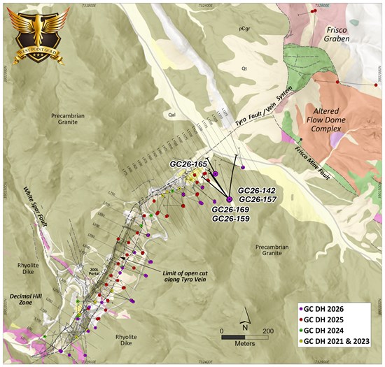
Figure 1. Plan view of the Main Tyro vein showing geology and drilling conducted in 2021, 2023, 2024, 2025, and 2026. Note the location of Hole Nos. GC26-157 (L1050), GC26-142, GC26-165, GC26-169 (L1100), and GC26-159 (L1200).
To view an enhanced version of this graphic, please visit:
https://images.newsfilecorp.com/files/5717/305058_3a615bcd2477d9f7_003full.jpg
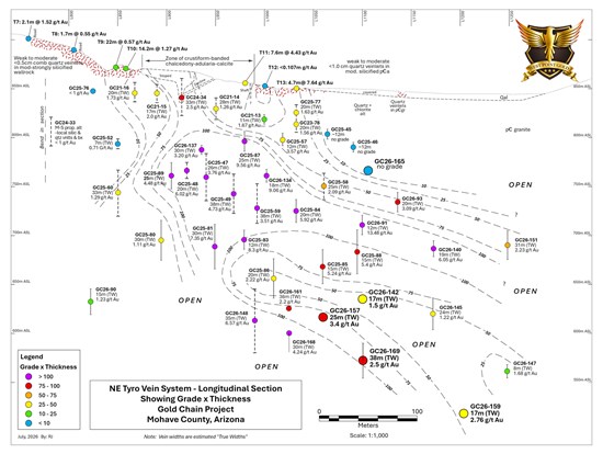
Figure 2. Longitudinal perspective of the Tyro NE zone contoured GT (g/t Au X estimated true thickness) highlighting the results from Holes GC26-142, GC26-157, GC26-159, GC26-165 and GC26-169.
To view an enhanced version of this graphic, please visit:
https://images.newsfilecorp.com/files/5717/305058_3a615bcd2477d9f7_004full.jpg
Line 1050 (GC26-157)
Section L1050 (Figure 3) reveals that the NE Tyro vein system is not exposed at the surface and is considered to be 'blind'. Holes GC25-045 and GC25-046 confirmed this and identified vein-related alteration but without quartz vein and associated gold values. The exposure of the gold zone at the surface a short distance to the southwest (L1025) suggests a northeast-trending plunge at about 30 degrees. This point (Top of the Vein Model) is shown in Figure 3.
Drill sections to the southwest, where gold mineralization is documented in surface exposures, i.e. Lines 875 to 1025, reveal robust gold deposition up to 300m vertically (down-dip) that remains open to depth. Sections to the northeast of Line 1050 show the top of the 'gold zone', which begins below the surface; this zone of gold deposition continues deeper as exploration proceeds to the northeast.
Hole GC26-157 intersected 32.0m at 3.4 g/t Au from 253 to 285m and contained 9.1m at 7.85 g/t Au, including a thick zone of vein and hydrothermal breccia (>50% vein). The elevation of this intercept is about 620m ASL and about 175m below the 'top' of the vein system and 230m below surface (Figure 3).
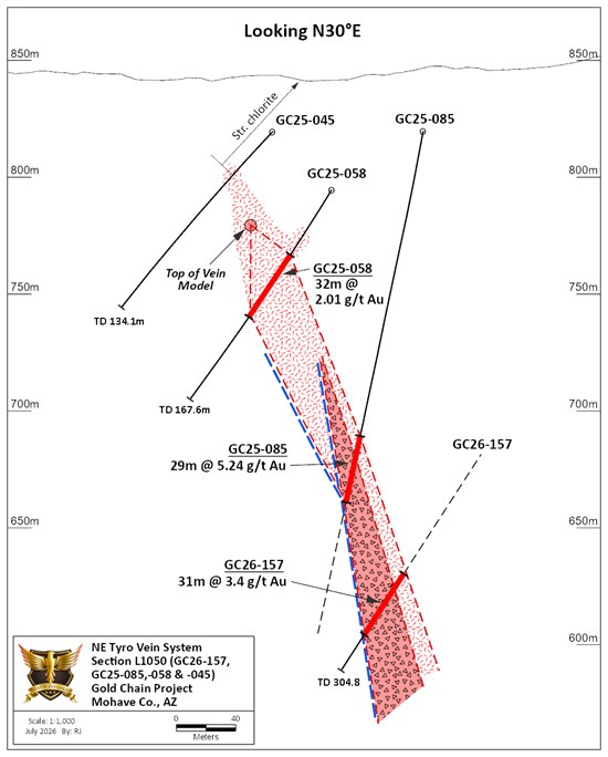
Figure 3. Geologic section drawn along Line 1050 showing vein and spatial relation between GC26-157 and GC25-058 and GC25-085.
To view an enhanced version of this graphic, please visit:
https://images.newsfilecorp.com/files/5717/305058_3a615bcd2477d9f7_005full.jpg
Line 1100 (GC26-142, GC26-165 and GC26-169)
Section L1100, shown in Figure 4, contains Holes GC26-165, GC26-142 and GC26-169. These holes were designed to test the vein zone both above and below Holes GC25-088 and GC26-091, where drilling revealed 44.2m at 5.46 g/t Au and 21.3m at 13.48 g/t Au, respectively. Hole GC26-142 crossed the vein system about 40m below Hole GC25-088 and intersected 23.6m at 1.51 g/t Au. The upper hole, GC26-165 (core), drilled to identify the upper limit of the vein system, identified several metres of quartz veinlets and local breccia with anomalous, low-level gold values. Alteration of the Precambrian granite across this zone consisted of moderate to strong illite-pyrite alteration replacing chlorite in the propylitic selvage. This hole, shown in Figure 4, better defines the upper limit of gold mineralization.
Hole GC26-169 crossed the vein system about 60m below Hole GC26-142 and encountered 51.9m at 2.5 g/t Au from 275.8 to 327.7m; this envelope contained 21.4m at 4.72 g/t Au in mostly quartz 'stockwork and breccia'. Relative to Hole GC26-142 (Figure 4), the mineralized package appears to be widening at depth and remains open below the 550m ASL elevation or about 150m below the upper extent of the vein package and about 300m below surface.
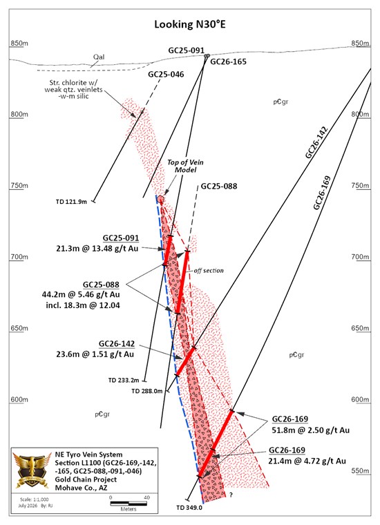
Figure 4. Geologic section drawn along Line 1100 showing vein and spatial relation between GC26-142, GC26-165 and GC26-169 and GC25-088 and GC25-091.
To view an enhanced version of this graphic, please visit:
https://images.newsfilecorp.com/files/5717/305058_3a615bcd2477d9f7_006full.jpg
Line 1200 (GC26-159)
Hole GC26-159 was designed to test the down-dip extension of gold mineralization intersected in Holes GC26-140, GC26-145, GC26-147 and GC26-151 (see press release here). Section L1200 (Figure 5) reveals an interpretation showing the top of the vein model at an elevation of about 725m ASL, about 125m below surface, which is consistent with sections to the southwest (Figures 3 and 4). The uppermost hole on this section, GC26-140, intersected 18.3m at 6.05 g/t Au (TW = 15m) while GC26-145, about 60m down-dip, cut 28.9m at 1.22 g/t Au (TW ~ 16m). Hole GC26-159, about 100m deeper, traversed 36.6m (TW ~ 17m) at 2.79 g/t Au, containing 9.14m at 6.46 g/t Au. The vein here appears to be steeper than observed in sections to the southwest. This intercept is about 150m below the top of the vein envelope and well above vein depths observed to the south; the vein system remains open.
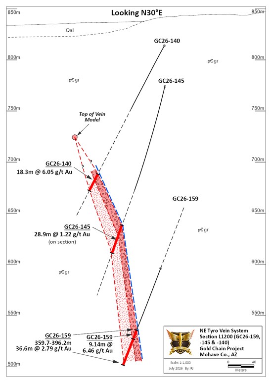
Figure 5. Geologic section drawn along Line 1200 showing vein and spatial relation between GC26-159 and GC26-147 and GC26-151.
To view an enhanced version of this graphic, please visit:
https://images.newsfilecorp.com/files/5717/305058_3a615bcd2477d9f7_007full.jpg
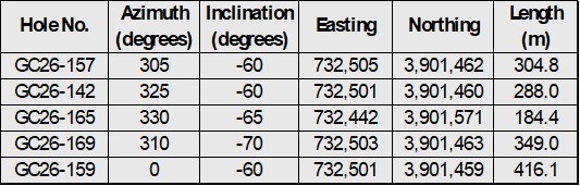
Table 2: Drill hole locations and descriptions
To view an enhanced version of this graphic, please visit:
https://images.newsfilecorp.com/files/5717/305058_3a615bcd2477d9f7_008full.jpg
Qualified Person
Robert Johansing, M.Sc. Econ. Geol., P. Geo., the Company's Vice President, Exploration, is a qualified person ("QP") as defined by NI 43-101 and has reviewed and approved the technical content of this press release. Mr. Johansing has also been responsible for overseeing all phases of the drilling program, including logging, cutting, labelling, bagging and transport from the project to American Assay Laboratories (AAL) of Sparks, Nevada. Reverse Circulation (RC) drill holes have a diameter of about 10cm (~4"), and samples have an approximate weight of 5 to 10kg. Core size is HQ (2.5"/63.5mm) and is logged, photographed and cut at the Company's Bullhead City sampling facility, including the insertion of blanks and standards. All samples are packaged for shipment at the facility and trucked to AAL in Reno. Samples were then dried, crushed and split, and pulp samples were prepared for analysis. Gold was determined by fire assay with an ICP finish, and over-limit samples were determined by fire assay and gravimetric finish. Silver plus 15 other elements were determined by Aqua Regia ICP-AES (IM-2A16), and over-limit samples were determined by fire assay and gravimetric finish. Both certified standards and blanks were inserted on site along with duplicates, standards and blanks inserted by American Assay. The results summarized above have been carefully reviewed with reference to the QA/QC results. Standard sample chain of custody procedures were employed during drilling and sampling campaigns until delivery to the analytical facility.
About West Point Gold Corp.
West Point Gold is an exploration and development company focused on unlocking value across four strategically located projects along the prolific Walker Lane Trend in Nevada and Arizona, USA, providing shareholders with exposure to multiple discovery opportunities across one of North America's most productive gold regions. The Company's near-term priority is advancing its flagship Gold Chain Project in Arizona.
Stay Connected with Us:
LinkedIn: linkedin.com/company/west-point-gold
X (Twitter): @westpointgoldUS
Facebook: facebook.com/Westpointgold/
Website: westpointgold.com/
FORWARD-LOOKING STATEMENTS:
Certain statements contained in this press release constitute forward-looking information. These statements relate to future events or future performance. Forward-looking statements include estimates and statements that describe the Company's plans, objectives or goals, including words to the effect that the Company or management expects a stated condition or result to occur. The use of any of the words "could", "intend", "expect", "believe", "will", "projected", "estimated" and similar expressions and statements relating to matters that are not historical facts are intended to identify forward-looking information and are based on the Company's current belief or assumptions as to the outcome and timing of such future events including, among others, assumptions about future prices of gold, silver, and other metal prices, currency exchange rates and interest rates, timing of the Company's maiden resource estimate, favourable operating conditions, political stability, obtaining government approvals and financing on time, obtaining renewals for existing licenses and permits and obtaining required licenses and permits, labour stability, stability in market conditions, availability of equipment, availability of drill rigs, and anticipated costs and expenditures. In particular, this press release contains forward-looking statements concerning the timing of a maiden resource estimate and the belief that Tyro NE will be open to depth following that estimate. The Company cautions that all forward-looking statements are inherently uncertain, and that actual performance may be affected by a number of material factors, many of which are beyond the Company's control. Such factors include, among other things: risks and uncertainties relating to West Point Gold's ability to complete any payments or expenditures required under the Company's various option agreements for its projects; and other risks and uncertainties relating to the actual results of current exploration activities, the uncertainties related to resources estimates; the uncertainty of estimates and projections in relation to production, costs and expenses; risks relating to grade and continuity of mineral deposits; the uncertainties involved in interpreting drill results and other exploration data; the potential for delays in exploration or development activities; uncertainty related to the geology, grade and continuity of mineral deposits; the possibility that future exploration, development or mining results may vary from those expected; statements about expected results of operations, royalties, cash flows, financial position may not be consistent with the Company's expectations due to accidents, equipment breakdowns, title and permitting matters, labour disputes or other unanticipated difficulties with or interruptions in operations, fluctuating metal prices, unanticipated costs and expenses, uncertainties relating to the availability and costs of financing needed in the future and regulatory restrictions, including environmental regulatory restrictions. The possibility that future exploration, development or mining results will not be consistent with adjacent properties and the Company's expectations; operational risks and hazards inherent with the business of mining (including environmental accidents and hazards, industrial accidents, equipment breakdown, unusual or unexpected geological or structural formations, cave-ins, flooding and severe weather); metal price fluctuations; environmental and regulatory requirements; availability of permits, failure to convert estimated mineral resources to reserves; the inability to complete a feasibility study which recommends a production decision; the preliminary nature of metallurgical test results; fluctuating gold prices; possibility of equipment breakdowns and delays, exploration cost overruns, availability of capital and financing, general economic, political risks, market or business conditions, regulatory changes, timeliness of government or regulatory approvals and other risks involved in the mineral exploration and development industry, and those risks set out in the filings on SEDAR+ made by the Company with securities regulators. Although the Company believes that the assumptions and factors used in preparing the forward-looking information in this corporate press release are reasonable, undue reliance should not be placed on such information, which only applies as of the date of this news release, and no assurance can be given that such events will occur in the disclosed time frames or at all. The Company expressly disclaims any intention or obligation to update or revise any forward-looking statements whether as a result of new information, future events or otherwise, other than as required by applicable securities legislation.
Neither the TSX Venture Exchange nor its Regulation Services Provider (as that term is defined in the policies of the TSX Venture Exchange) accepts responsibility for the adequacy or accuracy of this release.

To view the source version of this press release, please visit https://www.newsfilecorp.com/release/305058

© 2026 Canjex Publishing Ltd. All rights reserved.