Vancouver, British Columbia--(Newsfile Corp. - May 27, 2026) - Walker River Resources Corp. (TSXV: WRR) ("Walker" or the "Company") is pleased to announce the completion of the first geophysical survey at the Lapon Gold Project, located within Nevada's Prolific Walker Lane Gold trend, 60 km SE of Yerington, NV.
Highlights:
Property-wide airborne magnetic and radiometric survey completed to support structural interpretation and hydrothermal alteration targeting.
Several magnetic low and K/U - K/Th radiometric anomalies spatially correlate with known gold mineralization and drill intercepts, suggesting a potentially larger mineralized hydrothermal system than previously recognized.
RTP magnetic maps and 3D magnetic susceptibility inversion modeling defines an interpreted magnetite-destructive hydrothermal alteration zone, traceable in the inversion model to >900 m depth.
Geophysical signatures associated with the deposit area highlight additional exploration potential north and south of the Central Zone and Hotspot areas.
The survey, which covered the entirety of the Lapon Gold Project, was completed by Precision GeoSurveys Inc. and consisted of approximately 496 line-kilometres of airborne magnetic and radiometric surveying, including 3D unconstrained magnetic susceptibility inversion modeling.
Survey equipment included an Airbus AS350 helicopter equipped with a Scintrex CS-3 cesium vapor airborne magnetometer and a Medusa gamma spectrometry system. Survey lines were flown at 100-metre spacings with an average terrain clearance of approximately 30 metres above ground level. Selected infill areas at Lapon Canyon and Pikes Peak were surveyed at 50-metre line spacings to provide enhanced data resolution.
Initial interpretation of the geophysical dataset identified several magnetic and radiometric anomalies spatially associated with known gold mineralization and positive drill results. At Lapon, intrusion-hosted gold mineralization appears closely associated with localized magnetic low features identified within the 3D magnetic susceptibility inversion model.
The magnetic and radiometric survey results have enhanced the Company's understanding of the structural and alteration framework controlling gold mineralization at the Lapon Gold Project. Magnetic susceptibility inversion modeling has defined a coherent northeast-southwest trending magnetic low spatially coincident with drilling-defined mineralization. The magnetic low remains open both at depth and along strike, suggesting the hydrothermal alteration system associated with mineralization may extend beyond the limits of current drilling. The interpreted mineralized corridor is bounded by magnetic high features that may represent lithologic or structural controls influencing hydrothermal fluid flow and gold deposition.
Results from the geophysical survey will also be utilized to identify and prioritize potential deeper-seated intrusive bodies, including monzonitic and porphyritic intrusive phases, as well as associated gold-bearing feeder structures identified during the 2025 drill campaign. The dataset will additionally support geological mapping, structural interpretation, and future drill targeting across the Project.
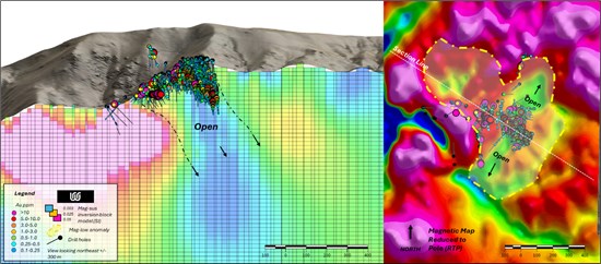
Figure 1. (Left) Magnetic susceptibility 3D inversion block model with drill traces and downhole assays. (Right) Plan view RTP magnetic map of the Lapon Canyon property with drill traces and downhole assays.
To view an enhanced version of this graphic, please visit:
https://images.newsfilecorp.com/files/5054/298921_d959f3d2b4197830_002full.jpg
Radiometric interpretation identified coincident potassium-to-uranium ("K/U") and potassium-to-thorium ("K/Th") ratio highs spatially associated with known gold mineralization, a magnetic low anomaly, and a prominent northeast-southwest regional lineament. The mineralized zone occurs within a potassium-enriched domain along a sharp radiometric boundary interpreted to represent a major structural and/or lithological corridor that focused hydrothermal fluid flow and gold deposition. Elevated potassium relative to uranium and thorium is consistent with hydrothermal alteration and provides independent support for the interpreted mineralized system at Lapon. The strong correlation between radiometric anomalies, magnetics, and drilling-defined mineralization demonstrates the survey's effectiveness in defining controls on gold mineralization and prioritizing additional drill targets along strike and at depth.
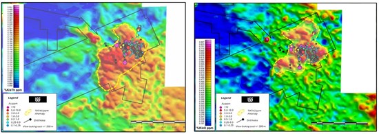
Figure 2. Plan view sections of the Lapon Canyon property showing %K/eU ppm and %K/eTh radiometric response with drill traces and downhole assays.
To view an enhanced version of this graphic, please visit:
https://images.newsfilecorp.com/files/5054/298921_figure2.jpg
Historically, gold mineralization at Lapon was interpreted to be largely confined to a broad, shallow, iron oxide-altered horizon. However, the 2025 drill programs identified intrusion-related gold mineralization associated with monzonitic intrusive rocks, significantly expanding the Project's exploration potential by opening previously unrecognized deeper-seated rock units capable of hosting additional mineralization. The identification of monzonite-hosted gold mineralization suggests the possible presence of a larger intrusive-related mineralizing system, a deposit style commonly associated with significant gold mineralization in Nevada. Elevated copper values observed in multi-element geochemical analyses further support this interpretation. The results may also reflect structurally controlled feeder zones, including higher-grade intervals intersected in drill hole LC-25-170.
Drilling completed in 2025 at the Hotspot zone significantly extended gold mineralization to the south and east. Drilling at Lapon Canyon is conducted systematically from strategically positioned drill pads typically spaced 30 to 60 metres apart, with each pad designed to accommodate multiple drill holes oriented in varying azimuths. Historical and recent drilling indicate that the gold system is predominantly sub-horizontal to moderately south-dipping in geometry, with evidence of steeper dipping, higher-grade shoots developed within the broader mineralized envelope. Recent drilling also successfully identified intrusion-hosted gold mineralization, a style not previously recognized at Lapon. The 2025 drill programs were designed to support both resource definition and exploration objectives, including infill drilling within the Hotspot deposit and testing for extensions along strike and downdip.
Michel David, Walker River's President & CEO states: "The results from the first ever geophysical survey at Lapon is very exciting. The discovery of geophysical anomalies coincident with positive drill results within dioritic and monzonitic units significantly increases the gold mineralization potential at the Project, opening up new areas for the exploration and potential discovery of intrusive hosted and iron oxide-based gold mineralization."
On-going work at Lapon Canyon consists of data compilation, interpretation and resource modelling. The 2026 drill program, beginning in early June, will focus on in-fill and exploration drilling to define the potential sources of the feeder zones and emplacement of discrete deeper seated intrusive bodies.
Results from previous and the 2025 drill programs, including the subsequent data compilation will be the basis for the completion of an initial NI 43-101 compliant mineral resource on the Project which is expected to be completed in 2026. In addition, work will continue at Lapon Canyon to identify future drill targets in the deeper-seated intrusive bodies.
The scientific and technical information contained in this news release has been reviewed, verified and approved by Dave Nuttall P.Geo, President of Geo Exploration, who is an independent Qualified Person as defined under NI 43-101 Standards of Disclosure for Mineral Projects.
About the Lapon Gold Project
The Lapon Gold Project consists of 147 unpatented mining claims totaling approximately 2,940 acres, located in the Wassuk Range within Nevada's Walker Lane structural corridor, a regionally significant northwest-trending deformation zone that hosts numerous gold and precious metal deposits. The Project comprises the Lapon Canyon claim block, the Pikes Peak claims located approximately 4 kilometres to the north, and the Rattlesnake and Range Front claims located approximately 3 kilometres to the west and at approximately 600 metres lower elevation relative to current drilling at Lapon Canyon. The Lapon Canyon portion of the Project, consisting of 96 claims, is subject to a US$5 million exploration stream earn-in agreement with Nevada Canyon Gold Corp., as announced on February 3, 2025. The Rattlesnake, Range Front, and Pikes Peak claim groups cover approximately 8 kilometres of prospective range-front structural trends interpreted to represent extensions of the mineralized system identified at Lapon Canyon and define several additional exploration targets. The Rattlesnake and Pikes Peak areas host historical workings, including adits, shafts, and underground development, as well as road access throughout portions of the claim blocks. Limited modern exploration has been conducted on these claim groups prior to Walker River's acquisition.
Neither the TSX Venture Exchange nor its Regulation Service Provider (as that term is defined in the policies of the TSX Venture Exchange) accepts responsibility for the adequacy or accuracy of this release.
Cautionary Statements Regarding Forward-Looking Information
This news release contains certain "forward-looking information" and "forward-looking statements" (collectively "forward-looking statements") within the meaning of applicable securities legislation. All statements, other than statements of historical fact, included herein, are forward-looking statements. Forward-looking statements are frequently, but not always, identified by words such as "expects", "anticipates", "believes", "intends", "estimates", "potential", "possible", and similar expressions, or statements that events, conditions, or results "will", "may", "could", or "should" occur or be achieved There can be no assurance that such statements will prove to be accurate and actual results and future events could differ materially from those anticipated in such statements. Forward-looking statements reflect the beliefs, opinions and projections on the date the statements are made and are based upon a number of assumptions and estimates that, while considered reasonable by the Company, are inherently subject to significant business, economic, competitive, political, social and regulatory uncertainties and contingencies. Many factors, both known and unknown, could cause actual results, performance or achievements to be materially different from the results, performance or achievements that are or may be expressed or implied by such forward-looking statements and the parties have made assumptions and estimates based on or related to many of these factors. Such factors include, without limitation, the ability to complete proposed exploration work, the results of exploration, continued availability of capital, and changes in general economic, market and business conditions. Readers should not place undue reliance on the forward-looking statements and information contained in this news release concerning these items. The Company does not assume any obligation to update the forward-looking statements of beliefs, opinions, projections, or other factors, should they change, except as required by applicable securities laws.

To view the source version of this press release, please visit https://www.newsfilecorp.com/release/298921

© 2026 Canjex Publishing Ltd. All rights reserved.