VANCOUVER, BC / ACCESS Newswire / October 29, 2026 / Core Silver Corp. ("Core Silver" or the "Company") (CSE:CC)(FRA:8ZR)(OTCQB:CCOOF) is pleased to provide an update on drill holes TL-26-010 to 015 of the phase one (1) drilling program (the "Program") at the Company's Touleary Project (the "Project"), located in Yukon, Canada. Mineralization has been intersected over a strike-length of 410 metres at the Discovery Zone. These holes, along with the four (4) previously reported holes, represent 2,436.3 metres of a planned minimum 3,000 metres of diamond drilling for 2026.
"We have intersected our broadest mineralized interval to date at the Touleary Discovery Zone," said Nick Rodway, CEO of Core Silver Corp. "We are seeing multiple new exciting mineralization assemblages and textures that are very encouraging given the early stage of the project. Hole 11 has intersected broad and very visually impressive VMS style massive sulphide mineralization along with multiple other holes indicating that this system has continuity and can be tracked. We are eagerly awaiting laboratory results to assess the grades of the observed mineralization. In the meantime, we look forward to exhibiting our drill core at the 2026 Yukon Geoscience Forum on November 18th and 19th in Whitehorse, Yukon."
Highlights
- Hole TL-26-011 intersected 21.5 metres of sulphide mineralization from 175 to 196.5 metres downhole, including an 11.5 metre interval containing massive sulphides with visible chalcopyrite and sphalerite ± covellite, bornite, and tetrahedrite from 175 to 186.5 metres downhole* (Figure 1).
- Discovery Zone mineralization is now traced over 410 metres of strike, with copper-bearing sulphides intersected in multiple drill holes.
- Multiple mineralized intervals in Hole TL-26-012: three separate intersections measuring 4.25 metres, 4.25 metres and 5.0 metres, with visible copper-bearing sulphides (Figures 2 & 3). Hole TL-26-014 (Figures 4 & 5) also intersected semi-massive copper-bearing sulphides and native copper in quartz veining*.
- Drill holes TL-26-010, TL-26-013, and TL-26-015 also intersected intervals with varying amounts of banded to disseminated pyrite ± chalcopyrite. These intersections continue to provide evidence for a larger footprint of VMS mineralization*.
- Significant room for further discovery: the approximately 3.5-kilometre interpreted geophysical trend hosting the Discovery Zone remains largely untested, with additional undrilled targets planned for testing (Figure 7).
- More Holes to come and all assays pending for 2026. Laboratory results will determine copper, zinc, gold, and silver grades.
*Mineral descriptions are based on visual observations and require laboratory confirmation. Visual observations do not establish metal grades or economic significance. Reported intervals are drill-core lengths; true widths have not been determined.
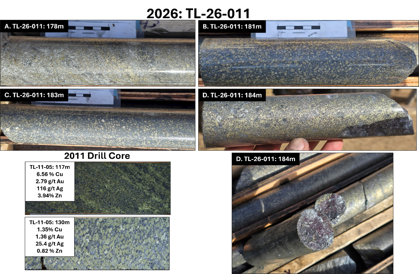
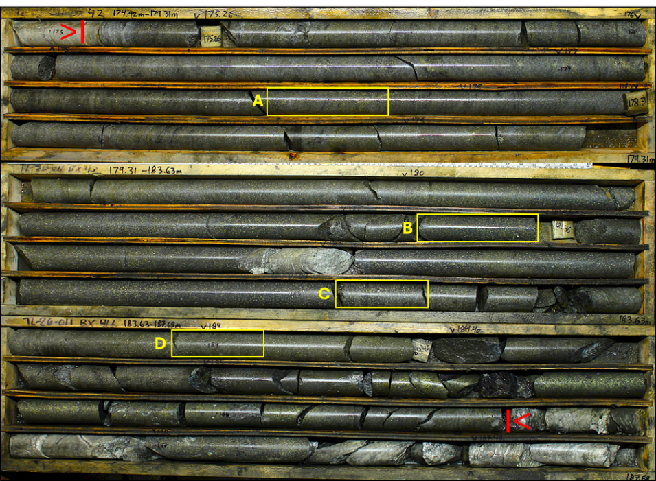
Figure 1: Drill core intersected in hole TL-26-011 with texturally similar intersects from the initial 2011 drilling at the Discovery Zone. Red arrows on core box photo indicate the mineralized zone from 175 - 186.5m (11.5m) with corresponding enlarged core photos (A - D); A. Massive sulphide zone displaying patchy sericite alteration with fine-medium grained pyrite + chalcopyrite showing preferential alignment along foliation (178m); B & C. Medium-coarse grained pyrite + chalcopyrite + sphalerite ± covellite ± bornite ± tetrahedrite in a sulphide matrix (181m / 183m); D. Massive sulphide consisting of chalcopyrite + pyrite + sphalerite ± covellite ± bornite ± tetrahedrite in a sulphide matrix (184m).
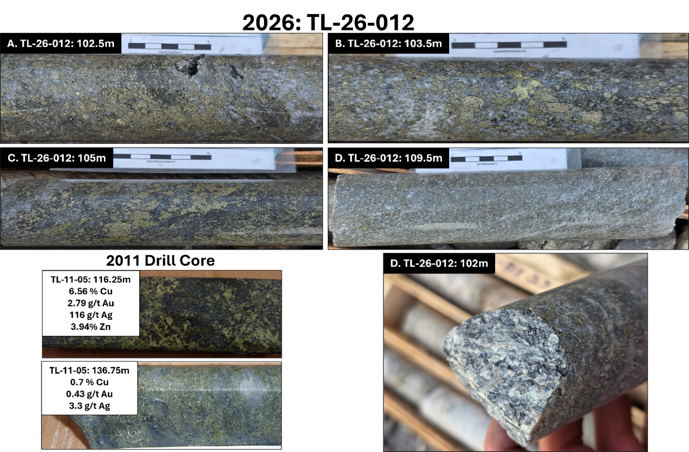
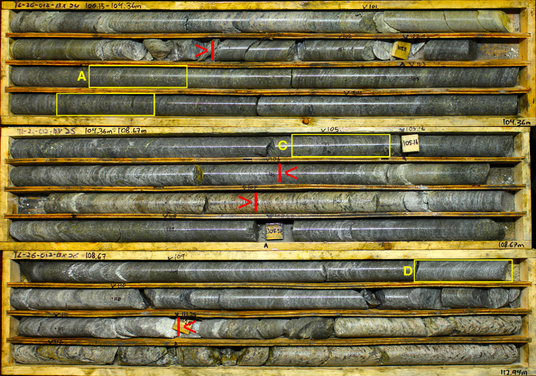
Figure 2: Drill core intersected in hole TL-26-012 with texturally similar intersects from the initial 2011 drilling at the Discovery Zone. The core box photo shows the mineralized zones (red arrows) from 101.75 - 106m (4.25m) and 107 - 111.25m (4.25m) with corresponding enlarged core photos (A - D); A to C. Mineralized zone with disseminated, blebby, and semi-massive pyrite + chalcopyrite ± sphalerite ± covellite ± bornite ± tetrahedrite (102.5m / 103.5m / 105m); D. Sericite schist with semi-massive and disseminated foliation parallel pyrite + chalcopyrite + sphalerite (109.5m).
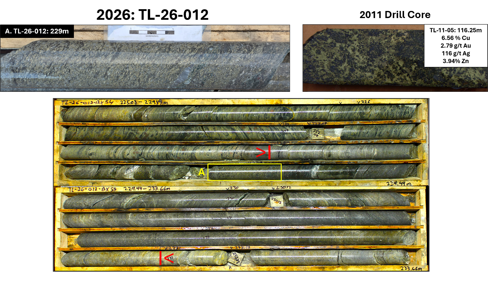
Figure 3: Drill core intersected in hole TL-26-012 with texturally similar intersects from the initial 2011 drilling at the Discovery Zone. The core box photo shows the mineralized zone (red arrows) from 228 - 233m (5m) with corresponding enlarged core photo; A. Sericite schist with semi-massive and disseminated foliation parallel pyrite + chalcopyrite + sphalerite (229m).
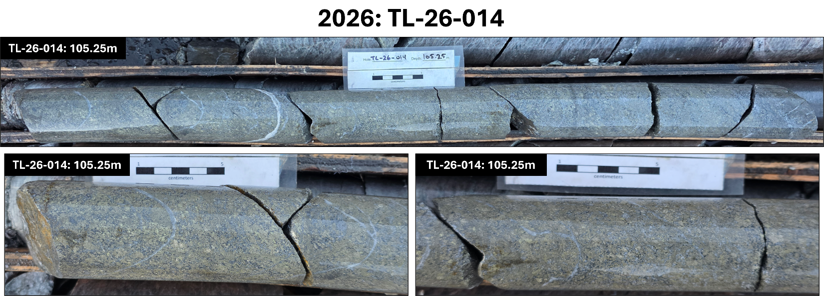
Figure 4: Drill core intersected in hole TL-26-014; Mineralization intersected at 105.25m is characterized by sericite alteration with abundant semi-massive chalcopyrite + pyrite.

Figure 5: Drill core intersected in TL-26-014. Sericite schist with dendritic native copper observed in quartz veining (136.5m); Fine grained disseminated pyrite + chalcopyrite transitioning to more massive pyrite + chalcopyrite (219m).
PHASE 1 DRILLING & PLANS
The 2026 drilling program has been primarily focused at the "Discovery Zone" (Target - 1) (Figures 6 to 8) which was identified from work completed from 2009 to 2011 by Arcus including soil sampling, airborne geophysics, trenching, and diamond drilling.
The 2011 diamond drilling returned significant assay results (taken from W.A. Wengzynowski - 2025) including:
- TL-11-005
- 2.25m @ 7.18% Cu, 3.55g/t Au, 4.30% Zn, 116g/t Ag (115.62 - 117.87m)
- 14.15m @ 1.45% Cu, 0.73g/t Au, 0.28% Zn, 16.5g/t Ag (124.5 - 138.65m)
- TL-11-002
- 3.17m @ 2.38% Cu, 2.01g/t Au, 1.38% Zn, 32.9g/t Ag (124 - 127.17m)
- TL-11-001
- 6.09m @ 1.37% Cu, 0.80g/t Au, 0.41% Zn, 14.5g/t Ag (85.61 - 91.7m)
- TL-11-003
- 0.59m @ 1.42% Cu, 1.15g/t Au, 2.81% Zn, 36.4g/t Ag (64.21 - 64.80m)
- 0.61m @ 4.01 % Cu, 2.18g/t Au, 0.93% Zn, 73.9g/t Ag (90.36 - 90.97m)
Multiple drill holes from the 2026 Phase One (1) drill program have intersected pyrite + chalcopyrite ± sphalerite ± covellite ± bornite ± tetrahedrite over various intercepts including:
- TL-26-007 from 165 - 166.5m (1.5m) and 178.5 - 180.5m (2m) downhole
- TL-26-008 from 208.5 - 215.5m (7m) downhole
- TL-26-011 from 175 - 186.5m (11.5m) downhole, part of a broader 21.5m intercept of sulphide mineralization intersected from 175 - 196.5m downhole
- TL-26-012 from 101.75 - 106m (4.25m), 107 - 111.25m (4.25m), and 228 - 233m (5m) downhole
- TL-26-014 from 105.25 - 106.25m (1m) with additional mineralized zones intersected at 136.5m and 219m
Mineralization has been observed as fine to medium grained blebby and foliation-parallel disseminated semi-massive to massive sulphides including pyrite + chalcopyrite ± sphalerite ± covellite ± bornite ± tetrahedrite.
Additionally, mineralization appears to be primarily spatially associated with sericite alteration and lesser silicification, often with barite, that has been observed both flanking and within mineralized intercepts.
Drill hole TL-26-010 intersected fine to medium grained pyrite within both mafic schist and gneiss units around 36.5m and 162.5m respectively.
Drill hole TL-26-011 intersected a significant mineralized zone from 175 - 196.5m (21.5m) including 11.5m ,from 175 - 186.5m, of massive sulphide mineralization displaying patchy sericite alteration with fine-medium grained pyrite + chalcopyrite showing preferential alignment along foliation (177m / 178m); Medium-coarse grained pyrite + chalcopyrite + sphalerite ± covellite ± bornite ± tetrahedrite in a matrix composed of fine-med grained sulphides (181m / 183m); Semi-massive to massive chalcopyrite + pyrite + sphalerite ± covellite ± bornite ± tetrahedrite in a sulphide matrix (184m). Additional sericite schist units containing pyrite were intersected from 81 - 83m; Sericite schist with semi-massive to disseminated pyrite and lesser chalcopyrite + sphalerite ± tetrahedrite ± covellite ± bornite from 85.25 - 90.15m; Sericite schist with abundant bands of layered pyrite and minor chalcopyrite + sphalerite ± tetrahedrite ± covellite ± bornite from 103.25 - 109.25m; Sericite schist with fine horizons of disseminated pyrite + chalcopyrite from 111.25 - 120.75m; Garnet schist displaying patchy silica alteration with fine-medium grained pyrite noted along foliation and locally massive clots composed of sphalerite and chalcopyrite observed at 174m; Mineralized zone with semi-massive to blebby pyrite + chalcopyrite + sphalerite from 189 - 193m.
Drill hole TL-26-012 intersected significant mineralization from 101.75 - 106m (4.25m) consisting of disseminated, blebby, and semi-massive pyrite + chalcopyrite ± sphalerite ± covellite ± bornite ± tetrahedrite; Mineralization consisting of patchy fine-medium grained pyrite ± chalcopyrite observed along foliation locally from 107 - 111.25m (4.25m); Mineralization within a unit of sericite schist with semi-massive and disseminated foliation parallel pyrite + chalcopyrite + sphalerite from 228 - 233m (5m). Additional mineralized sections include a mafic schist from 0 - 19m displaying sericite + silica alteration with fine grained pyrite noted along foliation at 16m; Sericite schist with patchy fine-medium grained pyrite ± chalcopyrite observed along foliation and locally semi-massive from 113.5 - 132.75m; Sericite schist with patchy fine grained disseminated pyrite observed locally along foliation from 149.5 - 169.5m; Gneiss with blebby pyrite ± chalcopyrite observed locally at 237m; Mafic gneiss with blebby pyrite ± chalcopyrite observed locally at 328m.
Drill hole TL-26-013 intersected a mineralized zone with section of semi-massive pyrite ± chalcopyrite, generally parallel to foliation, from 83 - 84.25m; Mafic schist with abundant pyrite and chalcopyrite at 87m; Sericite schist with abundant pyrite and fine-grained chalcopyrite from 94 - 101m; Sericite schist with fine-medium grained pyrite ± chalcopyrite noted along foliation at 103m.
Drill hole TL-26-014 intersected significant mineralization from 105.25 - 106.25m (1m) consisting of abundant semi-massive chalcopyrite + pyrite; Sericite schist with dendritic native copper observed in quartz veining at 136.5m (Figure 5); Fine grained disseminated pyrite + chalcopyrite transitioning to more massive pyrite + chalcopyrite at 219m (Figure 5). Additional mineralization included a sericite schist zone from 209 - 212.5m containing disseminated and foliation parallel pyrite + chalcopyrite.
Drill hole TL-26-015 intersected sericite schist units from 50.3 - 81.75m and 87 - 113m with patchy sections of fine-grained pyrite noted along foliation.
The correlation between the mineralization and alteration zones intersected in the 2011 and 2026 drilling is beginning to show the potential of a significant polymetallic system at the Touleary property.
Drill collar data for holes TL-26-006 through 015 can be seen in Table 1 below; Current release drill holes highlighted in yellow (Datum is NAD83 - Zone 7N):
2026 Drill Collars - Touleary Project |
Hole_ID | Length (m) | East | North | Elevation | Azimuth | Dip | Comments |
TL-26-006 | 300.2 | 594353 | 6987653 | 1242 | 360 | -50 | Assay Pending |
TL-26-007 | 191.4 | 594314 | 6987669 | 1246 | 360 | -50 | Assay Pending |
TL-26-008 | 257.6 | 594314 | 6987669 | 1246 | 360 | -65 | Assay Pending |
TL-26-009 | 213.4 | 594390 | 6987737 | 1246 | 360 | -50 | Assay Pending |
TL-26-010 | 249.9 | 594390 | 6987737 | 1246 | 0 | -65 | Assay Pending |
TL-26-011 | 251.5 | 594278 | 6987636 | 1235 | 0 | -50 | Assay Pending |
TL-26-012 | 342.9 | 594278 | 6987636 | 1235 | 0 | -65 | Assay Pending |
TL-26-013 | 199.6 | 594316 | 6987719 | 1242 | 310 | -50 | Assay Pending |
TL-26-014 | 254.5 | 594238 | 6987600 | 1221 | 0 | -50 | Assay Pending |
TL-26-015 | 175.3 | 593853 | 6987383 | 1167 | 0 | -50 | Assay Pending |
The total interpreted strike-length of the Discovery Zone geophysical signature is approximately 3.5 kilometres with only 335 metres having been tested by limited historic drilling.
Additional target areas that have been planned for testing in 2026 include:
Target - 4 was identified by a three (3) kilometre linear geophysical signature with correlating anomalous copper and zinc soil samples. No recent follow-up or historic drilling in this area.
Target - 5 was identified by a 1.2-kilometre linear geophysical signature with correlating anomalous copper and zinc soil samples. No recent follow-up or historic drilling in this area.
Target - 8 was identified by an underlying interpreted vent-complex (mapped) with multiple clusters of coincident anomalous copper, gold, silver, and zinc soil and hand-pit samples. No recent follow-up or historic drilling in this area.
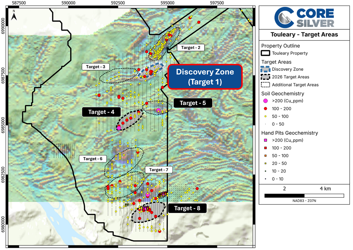
Figure 6: 2026 proposed exploration areas; Soil samples (Cu ppm) shown as circles; Background is airborne geophysics (First Vertical Derivative).
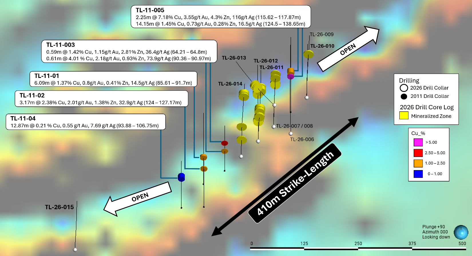
Figure 7: Plan view of the mineralized zones intersected in the 2026 Phase One drill program at the Touleary Project; Background is airborne geophysics (First Vertical Derivative). Assays pending for drill holes TL-26-006 through 015.
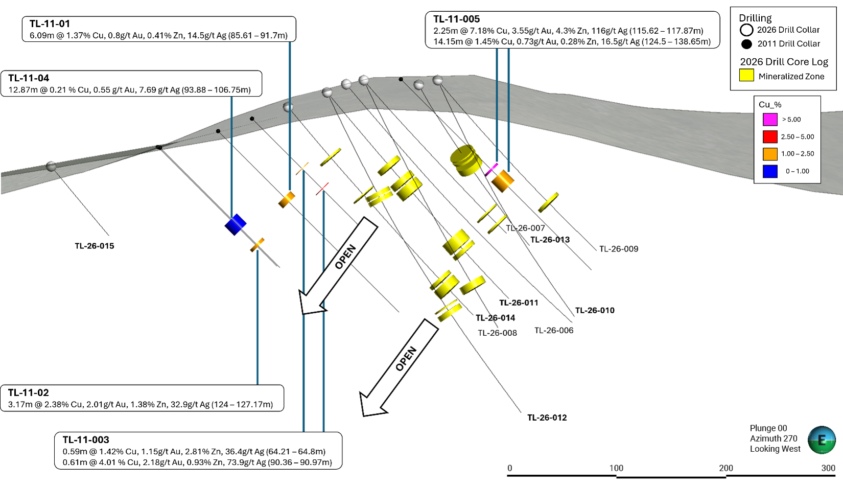
Figure 8: Section view (looking west) of the mineralized zones intersected in the 2026 Phase One drill program at the Touleary Project. Assays pending for drill holes TL-26-006 through 015.
DEPOSIT TYPE
Volcanogenic massive sulphide (VMS) deposits have also been referred to as volcanic-associated, volcanic-hosted, and volcano-sedimentary-hosted massive sulphide deposits. They typically occur as lenses of polymetallic massive sulphide that form at or near the seafloor in submarine extensional volcanic environments. VMS deposits are grouped according to base metal content, gold content and host-rock lithology. Base metal classification is most commonly used with specific deposit types divided into Cu, Cu-Zn, Zn-Cu and Zn-Pb-Cu groups according to their contained ratios of these three metals. Semi-precious and precious metal content (Ag and Au) can contribute significantly to the economics of VMS deposits. The model illustrated below (Figure 9) schematically shows a generic seafloor vertical feeder and mound-style system before and after deformation displaying the potential geometry of the Touleary system.
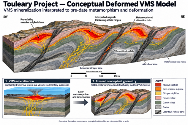
Figure 9: Schematic interpretation of a Deformed VMS System hosted in metamorphic rocks (Rodway - 2026).
The closest analogy and examples of these systems located in the Finlayson District are ~450 km southeast along the displaced Tintina Fault Zone in southeastern Yukon. Restoration of the Finlayson District to its original position places it adjacent to the Touleary area.
TOULEARY PROJECT & VMS POTENTIAL
The Touleary Project (the "Touleary") is a new volcanogenic massive sulphide ("VMS") discovery located within a well-known copper-endowed district in the Yukon Territory. The Touleary Project has the potential to emerge as a significant new VMS system within one of Canada's most prospective but underexplored mineral belts (Figure 10).
The Touleary represents a compelling exploration asset due to its combination of favorable geology, district-scale alteration, drill-proven metal endowment and strategic location within an emerging infrastructure corridor. VMS deposits are globally important sources of copper, zinc, silver and gold and are highly sought after due to their potential for high grades, clustered deposits and scalable district development opportunities.
In 2011, a total of 935.90 m of diamond drilling was completed in five holes at the Touleary Project. The drill program was primarily designed to test down-dip continuity of a mineralized interval exposed in a 2010 excavator trench, which graded 0.82 g/t gold and 14.30 g/t silver over 34 m. The mineralized exposure coincided with a linear magnetic low identified by the helicopter-borne magnetic survey. The holes intercepted elevated copper, zinc, lead, silver and gold bearing VMS style mineralization over a 300 by 100 metre area within a much larger 1,200-metre-long geophysical and geochemical anomaly, suggesting substantial room for expansion and additional discovery.
The Touleary Project benefits from several key characteristics commonly associated with major VMS systems, including:
- A large prospective land package within a well-established copper-rich geological belt with the potential for multiple types of mineralized systems.
- Strong exploration upside in an area that has seen limited modern systematic exploration.
- Exposure to both base and precious metals, providing leverage to multiple long-term commodity demand themes.
- Proximity to improving regional infrastructure, including the proposed Northern Access Route.
The proposed Northern Access Route and related infrastructure initiatives are viewed by management as potentially transformational for the broader region. Improved access into the Yukon's White Gold District could materially reduce exploration and development costs, improve logistics, lengthen operating seasons and unlock access to vast areas of highly prospective ground across the Tintina Belt that historically remained difficult and expensive to explore.
The Northern Access Route in the Yukon refers to a planned multi-million-dollar resource and development route designed to connect Dawson City with major mining developments in the west-central region, particularly the Coffee Mine. The road will traverse and service the heart of the prolific White Gold District. It is designed to service major proposed mining operations, including the Coffee Mine and the Casino Mine, while improving exploration access for junior mining companies. Development of the route requires ongoing government-to-government collaboration and agreements with local First Nations to ensure local socioeconomic benefits.
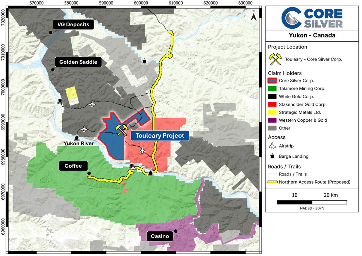
Figure 10: Touleary Project location and infrastructure; NOTE: The Northern Access Route is still under construction.
REFERENCES
Ryan, J.J. and Gordey, S.P., 2002 Geology, Southern Stewart River area, Yukon Territory (Parts of 115J14, 115O2,3,4,5,6,7); Geological Survey of Canada, Open File 4338, scale 1:100,000.
Bennett, V., 2012 Touleary Project, Dawson Range Mineral Belt, Yukon, Canada - SEM Study. Report prepared for Arcus Development Group Inc.
Leitch, C., 2011 Petrographic report on ten samples from the Touleary project, Yukon. Report prepared for Arcus Development Group Inc. by Vancouver Petrographics Ltd.
Smith, H, 2009 Assessment Report describing geochemical sampling and prospecting at the Touleary Property, western Yukon. Report prepared by Archer, Cathro & Associates (1981) Limited.
Hannington, M.D., Galley, A.G., Herzig, P.M., and Petersen, S. 1998 Comparison of the TAG mound and stockwork complex with Cyprus-type massive sulphide deposits, in Proceedings of the Ocean Drilling Program, Scientific Results Volume 158: p. 389-415.
Galley, A.G., Hannington, M.D., and Jonasson, I.R., 2007 Volcanogenic massive sulphide deposits, in Goodfellow, W.D., ed., Mineral Deposits of Canada: A Synthesis of Major Deposit-Types, District Metallogeny, the Evolution of Geological Provinces, and Exploration Methods: Geological Association of Canada, Mineral Deposits Division, Special Publication No. 5, p. 141-161
Franklin, J.M., and Hannington, M.D., 2002 Volcanogenic massive sulfides through time: Geological Society of America, 2002 Annual Meeting, Abstracts with Programs, v. 34, p. 283.
Singer, D.A., 1995 World-class base and precious metal deposits - a quantitative analysis: Economic Geology, v. 90, p. 88-104.
W.A. Wengzynowski (B.A.Sc., P. Eng), November 3rd, 2025, Technical Report Describing Geology, Mineralization, Geochemistry, Geophysics, Trenching and Diamond Drilling at the Touleary Property - prepared for Arcus Development Group Inc.
DRILL CORE SAMPLING & QA/QC
Following geological and geotechnical data collection, sample intervals were generally laid out on a two-meter basis with interval lengths adjusted to match changes in lithology, alteration, and mineralization. In areas of mineralization, sampling lengths were reduced to one-meter samples or shorter (but not less than 30 cm in length), depending on the distribution, style and tenor of mineralization. Sample tags were placed at the end of each sample interval, and cutting lines were created to ensure consistent cutting and bagging of drill core.
Analytical work is to be completed by ALS Canada Ltd. (ISO/IEC 17025‑accredited), with sample delivery in Whitehorse, Yukon; sample preparation in either Whitehorse, Yukon or Langley, British Columbia; and geochemical analysis in North Vancouver, British Columbia.
Rigorous procedures are in place regarding sample collection and data entry. Certified assay standards, coarse reject duplicates, field duplicates and blanks are routinely inserted into the sample stream to ensure integrity of the assay process. All reported results will have passed QA/QC screening by ALS and The Company.
Drill core is sampled using a diamond core saw, with the top half of each interval sent to the lab for analysis and the bottom half retained by the company. Half-core samples are fine-crushed to better than 70% and a 250 g split is pulverized to better than 85% passing 75 microns. Gold is determined for core samples using a 30 g charge by fire assay followed by an Atomic Emission Spectrometry finish (Au-ICP21). The fine fraction is analyzed for 48 elements using a four-acid digestion followed by inductively coupled plasma (ICP) combined with mass spectroscopy (MS) and atomic emission spectroscopy (AES) finish (ME-MS61).
NATIONAL INSTRUMENT 43-101 DISCLOSURE
Nicholas Rodway, P.Geo, (Licence No. 46541) (Permit to Practice No. 1000359) is President, CEO and Director of Core Silver, and a qualified person as defined by National Instrument 43-101- Standards of Disclosure for Mineral Projects. Mr. Rodway has supervised the preparation, verified and approved the technical content in this release on behalf of Core. Verification included reviewing historical assessment reports and laboratory certificates and a detailed review of 2026 drill logs, core pictures, and QA/QC protocols. No limitations were noted during the verification process.
ABOUT CORE SILVER CORP.
Core Silver Corp. is a Canadian mineral exploration company focused on the discovery and advancement of high-potential precious and base metal projects in Canada. The Company's Touleary Project is located approximately 115 kilometres south of Dawson City, Yukon. Touleary hosts a drill-confirmed, polymetallic volcanogenic massive sulphide (VMS) system containing copper, gold, zinc, and silver mineralization. Historical drilling at the Discovery Zone has identified significant mineralization, including 2.25 metres grading 7.18% copper, 3.55 g/t gold, 4.30% zinc, and 116 g/t silver. With only 335 metres of the approximately 3.5-kilometre interpreted geophysical trend having been tested by historical drilling, the Company believes Touleary offers substantial exploration potential. Multiple additional targets remain untested across the property, highlighting the potential for further discoveries within this prospective VMS district.
In addition, Core Silver holds 100% ownership of the Blue Property, comprising approximately 114,074 hectares (1,140 km²) in the Atlin Mining District of northwestern British Columbia. The Blue Property hosts multiple mineralized systems, including the Silver Lime and Laverdiere projects, which are prospective for high-grade silver, copper, gold, and associated base metals. The Company continues to advance its exploration strategy across both properties, targeting new discoveries and the expansion of known mineralized systems.
On Behalf of the Board of Directors
CORE SILVER CORP.
"Nicholas Rodway"
President & CEO
Tel: 604.681.1568
Neither the Canadian Securities Exchange nor its Regulation Services Provider (as that term is defined in the policies of the CSE) accepts responsibility for the adequacy or accuracy of this release.
FORWARD LOOKING STATEMENTS
This news release contains forward-looking statements. All statements, other than statements of historical fact that address activities, events, or developments that the Company believes, expects or anticipates will or may occur in the future, are forward-looking statements. The forward-looking statements reflect management's current expectations based on information currently available and are subject to a number of risks and uncertainties that may cause outcomes to differ materially from those discussed in the forward-looking statements. Forward-looking statements in this release include the anticipated assay results in respect of the drill holes, statements regarding the target areas for additional drilling and statements regarding the planned Northern Access Route. Although the Company believes that the assumptions inherent in the forward-looking statements are reasonable, forward-looking statements are not guarantees of future performance and, accordingly, undue reliance should not be put on such statements due to their inherent uncertainty. Important factors that could cause actual results to differ materially from the Company's expectations include that the assay results do not establish the presence of copper, zinc, gold and silver in the sampled intervals, and that the Company may not undertake or complete the planned drilling program as planned or at all. The Company expressly disclaims any intention or obligation to update or revise any forward-looking statements whether as a result of new information, future events or otherwise, except as required by applicable law.
SOURCE: Core Silver Corp.
View the original press release on ACCESS Newswire

© 2026 Canjex Publishing Ltd. All rights reserved.